


Introduction
The volcanic Javaketi Range (Lesser Caucasus, Georgia) has recently aroused the interest of both geologists and archaeologists on account of its rich environmental and geological history, the prehistoric exploitation of its raw materials and the discovery of archaeological sites ranging from the Palaeolithic to the Historical Ages (Gogadze Reference Gogadze1980; Kikodze Reference Kikodze1983). In 2012 and 2014, two systematic surveys were conducted on Mount Chikiani (Koyundağ) with the aim of defining the areas from which obsidian was obtained during different prehistoric periods, and to characterise its sources (Biagi & Gratuze Reference Biagi and Gratuze2016). A longer season of archaeological prospection was carried out in 2016. Among the many important finds was the discovery of a large number of obsidian mining pits along the northern and north-eastern lower slopes of the volcano (Figure 1), as well as several obsidian workshops. During the 2016 season, research focused on the 2417m-high trachyrhyolitic dome—a source of high-quality obsidian—emerging from the plain around 300m north-east of Lake Paravani.

Figure 1. Mount Chikiani: distribution map of the different groups of obsidian mining pits A–G (black dots) and workshops (red dots) discovered in July 2016, and location of Mount Biketi obsidian spots (R. Nisbet)
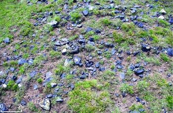
Figure 2. Mount Chikiani: central area of an obsidian workshop along the eastern upper slope of the mountain labelled CK16-20 at 2289m (41°28’ 42.2” N—43°52’ 55.1” E) (P. Biagi).
The Middle–Late Pliocene volcano, composed of trachyrhyolites, obsidians and perlites (Nasedkin et al. Reference Nasedkin, Sergeev, Alibegashvili and Rixiladze1983) is characterised by acidic lava flows whose age is still debated (Lebedev et al. Reference Lebedev, Bubnov, Dudauri and Vashakidze2008; Le Bourdonnec et al. Reference Le Bourdonnec, Nomade, Poupeau, Guillou, Tushabramishvili, Moncel, Pleurdeau, Agapishvili, Voinchet, Mgeladze and Lordkipanidze2012; Nomade et al. Reference Nomade, Scao, Guillou, Messager, Mgeladze, Voinchet, Renne, Courtin-Nomade, Bardintzeff, Ferring and Lordkipanidze2016; Lebedev & Vashakidze in press), although it seems to be no older than 2.8 Ma and not more recent than 2.4 Ma. The quality of the obsidian is excellent—homogeneous with no inclusions—and it occurs in a variety of colours.
Evidence from Ortvale Klde in north-western Georgia suggests that Chikiani obsidian was occasionally used from the end of the Middle Palaeolithic (Le Bourdonnec et al. Reference Le Bourdonnec, Nomade, Poupeau, Guillou, Tushabramishvili, Moncel, Pleurdeau, Agapishvili, Voinchet, Mgeladze and Lordkipanidze2012), but it was used much more extensively during the Early Neolithic to the Iron Age, as documented by finds from dozens of sites lying between the Black Sea and the Caspian Sea (Alikemek-tepesi in eastern Trans-Caucasia; Badalyan et al. Reference Badalyan, Chataigner, Kohl and Sagona2004).
At Chikiani today, obsidian is easy to access. The only obstacle to its exploitation is the thick snow cover that lasts more than six months of the year. At present, the area is treeless mountain steppe, but pollen analysis of sediments from Lake Paravani (Messager et al. Reference Messager, Belmecheri, Von Grafenstein, Nomade, Ollivier, Voinchet, Puaud, Courtin-Nomade, Guillou, Mgeladze, Dumoulin, Mazuy and Lordkipanidze2013) and from a Bronze Age kurgan to the west of the lake (Kvavadze & Kakhiani Reference Kvavadze and Kakhiani2010) show that the region was forested until at least 2000 BP. Access to Chikiani obsidian, however, is also possible through the Chrami River. Tributaries flowing down the slopes of the massif transport pieces of obsidian into the river and down to its lower course where sites of the Neolithic Shulaveri-Shomutepe culture, dated to the sixth millennium cal BC, are located (Badalyan et al. Reference Badalyan, Chataigner, Kohl and Sagona2004). Characterisation of the obsidian samples collected in 2012 and 2014, mainly along the eastern flanks of the mountain (see Biagi & Gratuze Reference Biagi and Gratuze2016: fig. 6), identified three different compositional groups, showing that various flows were exploited during prehistory, even though the manner and period of their exploitation are still to be defined.
The 2016 survey
During July 2016, the area around Chikiani was surveyed, mapping all visible archaeological features and collecting obsidian samples. The principal results are the identification and mapping of:
-
a) Seven previously unknown workshops, mostly along the northern and north-eastern slopes of the dome (Figure 1). They consist of obsidian scatters including sub-conical blade cores, flakes, blades, a few retouched tools and debitage (Figure 2).
-
b) A new area rich in obsidian artefacts, mainly unretouched flakes along the lower slope of Mount Biketi (Biket), 3km north of Mount Chikiani.
-
c) More than 100 kurgans of different size and shape, some of which are made exclusively of obsidian blocks (Figure 3), and several monumental stone alignments, one of which is more than 100m long.
-
d) Around 240 shallow pits, mostly 2–5m in diameter, on the northern and north-eastern sides of Mount Chikiani. These are interpreted as evidence of prehistoric mining. To date, eight clusters of pits (A–H in Figure 1) have been located, lying between 2160m and 2293m. Under good light conditions, they are clearly visible from a distance, running down the slopes (Figure 4 bottom). The pits are round or oval in shape (Figure 4 top), surrounded by low banks of excavated debris, frequently containing knapped obsidian flakes, sometimes tools and sub-conical cores. Obsidian samples from 18 of these features have been analysed at CNRS, IRAMAT laboratory of Orléans University, France.
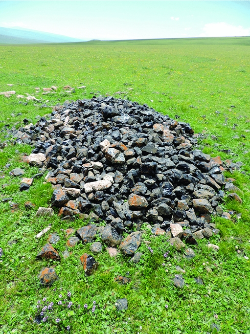
Figure 3. Mount Chikiani: kurgan made of obsidian blocks (P. Biagi).

Figure 4. Mount Chikiani: obsidian mining area G (bottom) and obsidian extraction pits mapped within mining area F (top) (P. Biagi).
Discussion
The size, shape and distribution of the mining pits suggests that preliminary testing and knapping of the obsidian blocks was undertaken at or very close to the extraction pits. The characteristics of the obsidian cores and tools (long, sub-conical cores with prepared platforms and indirect percussion blade detachments (Figure 5), plus a few flat-retouched instruments) recovered around these features appear to relate to different periods of the Kura-Araxes Culture of the Chalcolithic and the Bronze Ages (e.g. Kushnareva Reference Kushnareva1997; Palumbi & Chataigner Reference Palumbi and Chataigner2014). In contrast, ‘workshops’ are found at some distance from the extraction pits. Analysis is still ongoing, but the artefacts from these sites, including blades with parallel sides obtained by pressure technique, would suggest a Neolithic date for at least some of these features.
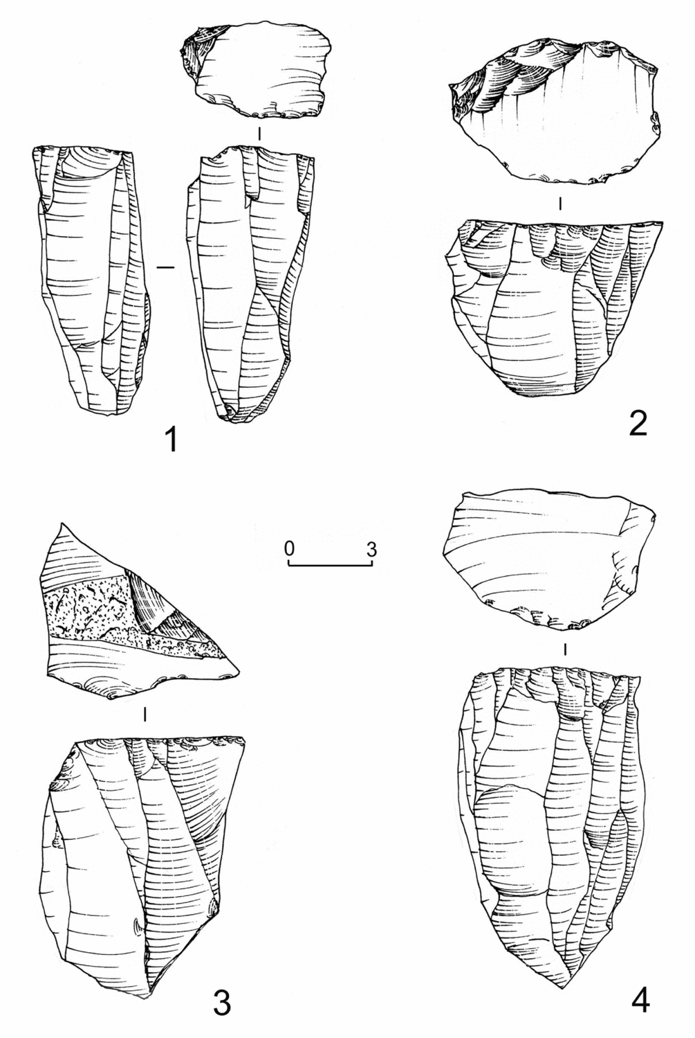
Figure 5. Mount Chikiani: obsidian blade cores from the mining-pits CKMD-7 (no. 1), CKMG-1 (nos 2 and 4) and workshop CK16-22 (no. 3) (P. Biagi and E. Starnini).
The discoveries at Chikiani shed new light not only on regional obsidian circulation, but also on the organisation of the acquisition and processing of raw materials, as already discussed for other regions of the Near and Middle East (Gopher & Barkai Reference Gopher and Barkai2014). Furthermore, it contributes to the study of the complexity of the Chalcolithic and Bronze Age societies of the Caucasus and neighbouring regions—this is the first evidence for obsidian mining fields recorded in this area—and emphasises the continued importance of knappable materials during the Metal Ages. This fact had been remarked upon in other regions of Eurasia (e.g. Delage Reference Delage2003, Reference Delage2007; Allard et al. Reference Allard, Bostyn, Giligny and Lech2008; Bostyn & Giligny Reference Bostyn and Giligny2014). In particular, studies of the Bronze Age Indus Valley civilisation (Biagi & Starnini Reference Biagi, Starnini, Kostov, Gaydarska and Gurova2008; Starnini & Biagi Reference Starnini and Biagi2011) have paid strong attention to the fundamental importance of knappable materials, and to the effort, organisation, labour and techniques involved in their procurement, manufacture, distribution and trade.
The characterisation of the specimens collected during the 2012 and 2014 surveys shows some compositional differences from the artefacts attributed to Mount Chikiani. Figure 6 indicates chemical compositions intermediate to groups defined by the geological samples previously collected. The new results obtained from the 2016 samples are in better agreement with the compositions of the artefacts. This demonstrates the importance of this newly surveyed area for obsidian supply during the Chalcolithic and Bronze Ages, and most probably for part of the Neolithic period too.
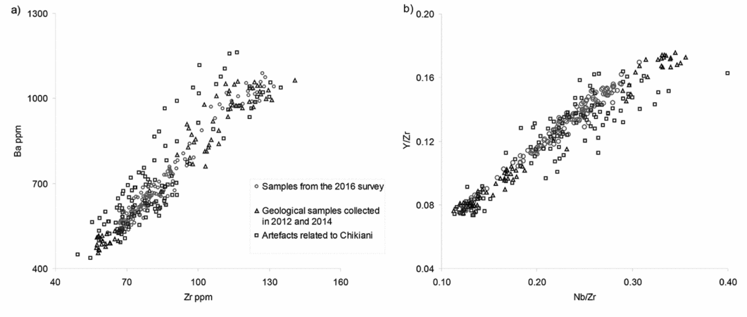
Figure 6. Mount Chikiani: binary diagram of the Zr-Ba contents (a) and of the Y/Zr-Nb/Zr ratios (b) of the 2016 geological corpus compared to our previous values (2012–2014 surveys) and those of the archaeological artefacts (B. Gratuze).
During the last two years, many perlite quarries have been opened on the slopes of the volcano. Regrettably, these have already damaged the heritage of Mount Chikiani—a unique archaeological landscape that so far finds no parallel elsewhere in the Caucasus.
Acknowledgements
Thanks to V. Licheli (I. Javakhishvili Tbilisi State University, Georgia) for his assistance and support for the 2012 and 2014 surveys. The 2016 fieldwork was made possible thanks to the financial support of Ca’ Foscari University of Venice Archaeological Research Funds, and EURAL Gnutti (Rovato, Brescia, I). We are also grateful to the I. Javakhishvili Tbilisi State University students who took part in the 2014 and 2016 surveys. Thanks are further due to V.A. Lebedev (IGEM, Russian Academy of Sciences, Moscow, Russian Federation) for his critical reading of the original text and information on the geological structure of Mount Chikiani.


