


Introduction
Recent years have seen lively discussions of the earliest centuries of the Neolithic period in Britain. The movement of new populations into these islands from the end of the fifth millennium BC onwards has been discussed either in terms of sweeping migrations (Brace et al. Reference Brace2019) or, alternatively, more protracted, intricate and incremental processes that may have involved the fusion of peoples from diverse backgrounds (Cummings et al. Reference Cummings, Hofmann, Bjørnevad-Ahlqvist and Iversen2022; Thomas Reference Thomas2022). The construction of timber halls may have had an instrumental role in the formation of new social groups, while the subsequent introduction of mortuary monuments may be linked to emerging concerns with descent and lineage (Barclay & Harris Reference Barclay, Harris, Bickle, Cummings, Hofmann and Pollard2017; Ray & Thomas Reference Ray and Thomas2018: 105–7). Overlapping with these developments was the creation of the first ditched enclosures in southern Britain, which embodied new emphases on gathering, sociability, exchange, display and competition (Whittle et al. Reference Whittle, Bayliss, Healy and Last2022). In this contribution, we present the results of the excavation of, and a chronological model for, a newly investigated site that provides insights into all these critical and interrelated processes.
Dorstone Hill, a triangular flat-topped promontory that extends southwards from an upland watershed between the valleys of the rivers Wye and Dore in south-west Herefordshire, is the setting for a remarkable complex of Early Neolithic structures (Figure 1). The hilltop is formed of Devonian sandstone and interbedded mudstones and siltstones, and its summit commands extensive views toward the Black Mountains of Wales (with its group of Neolithic long cairns) to the south-west and the Shropshire Hills to the north-east. Since 2011, prehistoric activity in this area has been investigated by the ‘Beneath Hay Bluff Project’, a joint initiative by the University of Manchester and Herefordshire Council. One of the principal objectives of the project was the search for a Neolithic causewayed enclosure to complement Hill Croft Field, Bodenham, at the time the only known example in Herefordshire (Dorling Reference Dorling2007; Whittle et al. Reference Whittle, Healy and Bayliss2011: 521–4). While there are numbers of enclosures in the Gloucestershire Cotswolds and south Wales, Herefordshire has until recently represented something of a gap in the distribution (Davis & Sharples Reference Davis and Sharples2017). At Dorstone Hill, trial excavations by Roger Pye and Christopher Houlder in the 1960s identified subsoil features and traces of stone walling, while field survey by English Heritage in the 1990s drew attention to a low bank that crossed the narrow neck connecting the hilltop to the escarpment (Pye Reference Pye1967; Oswald et al. Reference Oswald, Barber and Dyer2001: 152). Ostensibly, this latter feature could have represented the rampart of a Neolithic ‘promontory enclosure’ comparable with Crickley Hill, Gloucestershire (Dixon Reference Dixon, Burgess, Topping, Mordant and Madison1988); both LiDAR and local testimony, however, indicated that it was composed of three separate features arranged end-to-end and which, before bulldozing in the 1940s, had stood to a greater height. Our recent fieldwork now demonstrates these mounds to be three Early Neolithic long barrows, which seal the remains of even earlier structures; in addition, we located a causewayed enclosure at the southern extremity of the hill (Figure 2). This article outlines the findings of investigations conducted between 2011 and 2019, and discusses them in the context of Bayesian modelling of the available radiocarbon dates; details of the modelling can be found in the online supplementary material (OSM).

Figure 1. The location of Dorstone Hill, Herefordshire (figure by Nick Overton).

Figure 2. The location of the trenches excavated on Dorstone Hill (figure by Nick Overton).
The pre-mound buildings and mortuary structure
Initial trenches across the apparent ‘bank’ crossing the neck of land between the hilltop and the escarpment found no evidence for any associated ditch, and revealed that each of the three mounds was composed of a core of orange burnt clayey material, sealed beneath a layer of turf and a loose cairn of stones (Figure 3). The ‘burnt clay’ was a heterogeneous mixture composed of various materials: burnt soil/subsoil, cob or daub containing animal dung or hair as a binding agent, as well as charcoal smudges and fragments of charred wood (including worked structural timbers). Along the axis of each mound, this material overlay a charcoal-rich horizon, which again included charred structural timbers and stakes. In some areas the burnt deposit seems not to have been in situ, and instead had been piled up, and cut to a face against which turf was stacked in the process of constructing the mounds. This indicates that the long barrows must have been built very soon after the destruction of what proved to be a series of timber buildings (see below).

Figure 3. Plan of the three long mounds on Dorstone Hill (figure by Nick Overton).
Survey of magnetic intensity by TigerGeo revealed strong magnetic anomalies associated with these mounds. Spot-sampled magnetic susceptibility measurements yielded values in excess of 100 × 10-5 SI units, well within the range for soils exposed to strong heating and subsequent cooling. Total magnetic intensity anomalies were uniformly high within the footprint of each mound, exceeding 50nT positive amplitude against a natural background that varied less than 0.5nT across 10m. In contrast, likely non-heated soils accumulated within the ditch segments of the causewayed enclosure contributed no more than 3nT to the ambient field. The difference in amplitude between these anomalies and those from the mounds is again consistent with the strong heating of soils. The accumulation of heated clay within a rectangular area distinct to each mound may be indicative of daub walls, the wooden structure of which provided the necessary reducing environment, as well as heat, for the conversion of natural soil iron compounds into more magnetic forms (the ‘Le Borgne effect’: Tite & Linington Reference Tite and Linington1975).
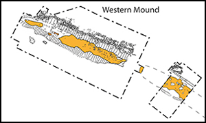
At each of the three mounds, postholes or other structural features forming substantial pre-mound structures were sealed beneath the in situ burning horizon; based on date and configuration, these structures are best understood as ‘halls’ of primary Neolithic date (Barclay & Harris Reference Barclay, Harris, Bickle, Cummings, Hofmann and Pollard2017). The start of Neolithic activity at Dorstone occurred in 3910–3760 cal BC (95% probability; start Dorstone sensitivity 2; Figure 4), according to the preferred Bayesian model (see OSM). As with some other similar buildings in Britain and Ireland, these structures had been deliberately destroyed by fire. The structure beneath the western mound retained the most architectural detail (Figure 5). It was trapezoidal in plan, approximately 20 × 14m in extent. Sizeable sockets for load-bearing posts were present on the building's northern side, with the outer walls represented by smaller postholes. On the axis of the structure, a shallow depression potentially worn by footfall on an earthen floor appeared to mark a passage of movement from a putative entrance in the eastern wall. The southern side of the building had been destroyed by the later robbing of the stone wall of the succeeding long mound. Overall, the western building is strikingly similar in plan, size and orientation to the Early Neolithic hall at Yarnton in Oxfordshire, which is slightly earlier in date (Hey et al. Reference Hey, Bell, Dennis and Robinson2016: 51). The first activity beneath the western mound occurred in 3850–3710 cal BC (95% probability; first Western premound; Figure 4).

Figure 4. Bayesian radiocarbon chronological model for Dorstone Hill, Model 2 (figure by Seren Griffiths and Nick Overton).

Figure 5. Plan of the western building (figure by Julian Thomas).
The full plan of the central building was only partially recovered, but consisted of an aisled structure approximately 6m wide, with internal structural posts and partitions, in the form of lines of carbonised stakes, and post-in-slot outer walls. Carbonised timbers identified within the burnt debris of the building included one block with a mortice hole, and a possible tenon on the end of one of several L-shaped members. Based on a single radiocarbon measurement, activity can be dated to the thirty-ninth or thirty-eighth centuries cal BC, in 3870–3760 cal BC (95% probability; SUERC-62311; Figure 4).
In the eastern mound, a very distinct rectangular deposit of burnt building debris, measuring 9 × 3m in extent, contained a number of charred structural timbers, including eight oak ‘planks’, running parallel to each other, interspersed with a series of in situ carbonised oak sapwood posts. It is likely that these represent the traces of a suspended wooden floor. Activity beneath the eastern mound began in 3805–3730 cal BC (95% probability; first Eastern premound; Figure 4).
The pre-mound activity beneath the central mound (SUERC-62311) could be slightly earlier than that beneath the western and eastern mounds. The single radiocarbon measurement available, however, cannot provide a definitive estimate for the chronology of this part of the complex. It is most probable (68% probability) that the pre-mound activity beneath the western mound (first Western pre-mound) occurred before the first activity beneath the eastern mound (first Eastern pre-mound).
While the remains of these three buildings were fragmentary, certain constructional details indicate that each was morphologically distinctive and potentially drew on contrasting architectural traditions: the trapezoidal form, earthen floor and massive structural posts of the western building; the aisled, post-in-slot structure, stake partitions and smaller size of the central building; and the suspended floor of the eastern building.
One further structure was sealed beneath the eastern mound, but not covered by the burnt daub deposit. Placed between the eastern and central timber structures, and overlapping with neither, was a 6m-long and 15cm-deep steep-sided trough cut into the natural geology, with portions of stone ‘paving’ in the base (Figure 6). This was flanked at each end by 0.5m-deep ‘D’ sectioned postholes, which presumably held large split posts, and surrounded by a horseshoe-shaped ditch. This feature is best understood as a timber mortuary structure, comparable with those documented at Fussell's Lodge, Wayland's Smithy and Haddenham, which date to the thirty-eighth to the thirty-sixth centuries BC (Whittle et al. Reference Whittle2007: 127). A discrete body of charcoal and cremated bone in the southern side of the ditch, deposited immediately before the chamber was decommissioned (see below), had been generated in multiple events in the thirty-eighth and thirty-seventh centuries cal BC, the last of these occurring in 3770–3675 cal BC (95% probability; last mortuary structure ditch; Figure 4). This estimate provides a terminus post quem for the decommissioning of the linear mortuary structure, whilst the estimates associated with the eastern timber building and the mortuary structure could be contemporaneous. In other words, a distinctive mortuary facility may have stood alongside at least one of the wooden halls, constituting a very unusual architectural complex.

Figure 6. The linear mortuary structure beneath the eastern mound (figure by Nick Overton).
The long barrows
The remains of the timber buildings, and of the mortuary structure, were sealed beneath three long mounds. The residues of the burnt structures were gathered and shaped, before being surrounded and capped with a deposit of stacked turf and earth. Echoing the contrasting forms of the pre-mound structures, the three long mounds were each architecturally distinct. In the central mound, the earthen deposits were revetted by a palisade of upright posts set in a continuous slot, comparable with that at Fussell's Lodge (Wysocki et al. Reference Wysocki, Bayliss and Whittle2007: 66). When this palisade rotted, the mound had apparently collapsed outward, spreading over a larger area and effectively merging with the eastern mound. Only at this point was a loose cairn of stones laid over the splayed mound. This extended to the north and south of the barrow core, but had been scraped away from the centre by modern bulldozing.
In the western mound, the primary daub and turf layers were contained on the northern side of the barrow by a continuous dry-stone wall, which turned abruptly at the western end to enclose the tail of the mound. This walling was much more structured than the loose cairn material on the other mounds. The underlying subsoil surface had been cut to form a platform to receive the wall, truncating some of the postholes of the building beneath. A corresponding wall had presumably existed on the southern side of the barrow, presumably removed by a massive robber trench of much later date. Toward the eastern end of the north wall, a series of loops of masonry formed four cellular ‘buttresses’. Assuming that similar arrangements had existed on the southern side, the effect of these structures would have been to enhance the trapezoidal plan of the mound, echoing the wedge-shaped building that it had replaced. The cellular character of these elements resembles the internal architecture of the long cairns of the Cotswold-Severn tradition (Darvill Reference Darvill2004: 86), but the deployment of drystone cells around a core of daub and turf is otherwise unprecedented. Toward the western end of the mound a small chamber had been set into the wall. It was defined by a series of orthostats, the upper part of one being truncated by a bulldozer in the twentieth century. No further chamber structure existed on the axis of the mound, so that the burnt building debris had not been disturbed by any construction subsequent to its deposition.
In the linear chamber beneath the eastern mound, the lack of post-pipes in the large postholes, the homogeneous fill of postholes and chamber, and the disturbance of the stone paving indicate that the posts were withdrawn, and the structure was intentionally backfilled and decommissioned. The discrete charcoal and cremated bone deposit in the southern portion of the ditch was capped by a layer of rough stone entirely filling the ditch (Figure 6). The backfilled chamber and ditch were then sealed by a small earthen mound; the extensive presence of charcoal and burnt daub fragments within the mound suggest that this occurred after the eastern timber building was burnt down. Directly to the east of the mortuary structure, the burnt remains of the eastern building had been heaped up to form the core of the eventual mound. The northern and southern edges of this core (burned) material had been deliberately cut back to form well-defined sharp vertical sides to this deposit (Figure 7).

Figure 7. Sections through the eastern mound (figure by Nick Overton).
As with the western and central mounds, this burned material was then covered by earth or turf. At the western end, this material overlay the smaller mound sealing the linear chamber, indicating that the eastern portion of the barrow was a later addition. Furthermore, if the charcoal and daub in the material forming the small mound over the mortuary structure were derived from the eastern structure, it would suggest the mortuary structure was decommissioned and mounded between the burning and later mounding of the eastern structure/mound. After the two mounds were joined, a terrace was cut along their north and south sides and an extensive loose stone cairn was thrown up, which we assume to have covered the entire mound (Figure 8).

Figure 8. Aerial view of the eastern mound under excavation, 2016 (photograph by Adam Stanford).
We estimate that the central mound was constructed in 3825–3650 cal BC (95% probability; construct Central Mound; Figure 4; or in 3805–3715 cal BC; 68% probability). The eastern mound was then constructed in 3765–3660 cal BC (95% probability; construct Eastern Mound; Figure 4, or in 3755–3715 cal BC; 40% probability or 3695–3665 cal BC; 28% probability). The western mound was constructed in 3785–3670 cal BC (95% probability; construct Western Mound; Figure S3), most probably in the last three-quarters of the thirty-eighth century cal BC, in 3775–3710 cal BC (68% probability).
These mound construction events occurred over 1–130 years (95% probability) or 5–75 years (68% probability; duration construction). It is possible that the central mound was constructed first; but as noted above, the chronology of the central mound is under-represented. With the better-dated eastern and western mounds, it is more probable (78% probability) that the western mound was constructed before the eastern mound. If we were to consider the mounds as a single unitary construction, we estimate that the complex was most probably created in the thirty-eighth century cal BC, in 3770–3705 cal BC (90% probability).
The final phase of prehistoric activity in the eastern mound was represented by four large pits, each up to 2m in diameter, that had been dug, shaft-like, through the stone and turf layers of the mound, and down to the burnt building deposit that would have been highly conspicuous to the Neolithic excavators. The bases of these pits were lined with massive slabs of stone and used as significant loci of deposition. One contained cremated human remains and another the cremated remains of animals (including cattle), suggesting an enduring and perhaps reverential relationship with these monuments. These later features date to 3760–3650 cal BC (95% probability). Further to the west, almost immediately above the south-western terminal of the horseshoe-shaped ditch and the western end of the linear chamber, we located another quite different invasive feature: a small, flat-based circular pit, approximately 0.5m in diameter. While only the base of this feature survived, it contained a fine polished flint axe and a bifacially worked flint knife. A polished stone axe recovered from a modern drainage channel immediately beside the pit probably came from the same feature. Remarkably, a series of flint flakes found in the pit appear to be debitage from the manufacture of the bifacial knife, indicating that it had not been in circulation for any period, and had arguably been made specifically for immediate and significant deposition. If this is the case, it is probable that this assemblage of stone tools was buried as an act of veneration, celebrating the dead who had been interred in the chamber.
Stratigraphically equivalent to the intrusive pits in the eastern mound is a series of stone cists or chambers inserted into the northern side of the central long barrow, following its collapse, settling and capping with a stone cairn. One of these cists contained a leaf-shaped arrowhead made from a flake from a polished flint axe, displaying a clear impact fracture. It is conceivable that this object entered the cist within a human body or body part, long lost to the acidic soil. Several deposits of cremated bone were also introduced into the eastern end of the central mound at this point. All of these secondary features are either funerary or memorial in character. Two further pits, containing cremated bone, ceramics, flint implements and hundreds of flakes of worked rock crystal were located immediately to the south of the western and central mounds, and can be considered as being similarly commemorative in character.
The causewayed enclosure
Although the ‘bank’ that was initially identified as the perimeter of a Neolithic enclosure transpired to be something quite different, a magnetometer survey of the entire hilltop revealed the presence of a causewayed enclosure on the south-east extremity of the hill, overlooking the Golden Valley. The enclosure is elliptical in plan, and approximately 150 × 120m in extent, with a single circuit of interrupted ditch segments (Figure 9). On the north-east side, the ditch circuit is flattened in plan, running parallel to the line of the three mounds to the north. On the steeper southern and eastern sides of the hill, the enclosure has been severely disturbed by later quarrying, but the northern perimeter facing across the undulating surface of the hilltop is intact. Three large portions of the ditch were investigated between 2017 and 2019. In places the ditch was masked by colluvium, or had been affected by gleying (soil formation under anaerobic conditions caused by waterlogging), but we were still able to identify a complex sequence of digging, backfilling and recutting.

Figure 9. Aerial view of the Dorstone Hill causewayed enclosure, 2017 (photograph by Adam Stanford).
The initial form of the enclosure comprised a series of small, oval ditch segments, but many of these had been sliced through subsequently by linear, slot-like recuts, leaving entrance causeways only to the north-east and north-west. There were also bowl-shaped recuts of various sizes, some of which had been lined with stone, thus evoking the intrusive features in the eastern long mound, which appear to have been contemporary with the digging of the enclosure ditches. Some of the recuts had simply been backfilled, but others contained placed deposits of various kinds. In a ditch terminal flanking the north-west entrance one recut contained a concentration of animal bone, together with a large fragment of a carinated bowl. Another major recut, which had removed the causeway between two ditch segments, had been filled with a mass of large angular sandstone fragments. Substantial sandstone boulders had also been toppled into the ditch on either side of the north-east entrance. Elsewhere, accumulations of smaller stones had apparently rolled into the ditch from the inner side of the enclosure, perhaps having been used to revet an unstable bank.
The causewayed enclosure could be slightly earlier in date than other examples in south Wales and the Marches. The evidence available for the Dorstone enclosure places the earliest activity here in the very late thirty-eighth or the thirty-seventh centuries cal BC (3770–3640 cal BC; 95% probability; or 3710–3645 cal BC; 68% probability; first_Dorstone_enclosure; Figure 10). Given this estimate, Dorstone certainly pre-dates the causewayed enclosures at Lower Luggy near Welshpool, Womaston in the Walton Basin, and Caerau near Cardiff. It is also 74% probable that the first activity associated with the Dorstone enclosure pre-dates the first activity associated with the Banc Du enclosure in Pembrokeshire (start_Banc_Du; Figure 10). Recent reappraisal of the radiocarbon data of the Hill Croft enclosure (Griffiths et al. 2022) indicates an alternative chronology to the interpretation given in Whittle et al. (2011: 523). This reappraisal suggests the Hill Croft enclosure may have been built in 3975–3650 cal BC (95% probability; or 3760–3675 cal BC; 68% probability; revised_build_Hill_Croft; Figure 10), perhaps a little earlier than the Dorstone example.

Figure 10. Comparisons of the date estimates for the Dorstone causewayed enclosure and other enclosures from southern Britain (figure by Seren Griffiths and Nick Overton).
Artefacts and other finds
We recovered 1328 items of worked flint from the mounds and enclosure, 604 of these from primary contexts. Little difference can be discerned between the assemblages from these different contexts. Flint seems to have been brought to the site in a semi-prepared form as there is little evidence for primary reduction amongst the debitage (<9 per cent); the closest potential sources for the flint are approximately 20km away (Elliot Reference Elliot2019). The assemblage is dominated by flakes (77 per cent). Cores are rare, but the presence of core preparation and maintenance pieces indicates production on-site or nearby. Diagnostic lithic artefacts include 14 pressure-flaked leaf-shaped arrowheads, a bifacial knife and 18 complete or fragmentary polished axes of flint or stone, including specimens probably from North Wales and Cumbria (Overton et al. Reference Overton2022a: 8).
Other material recovered from the mounds and enclosure includes an assemblage of 337 pieces of knapped rock crystal, a non-local water-clear quartz which forms six-sided hyaline crystals, with the closest sources in North Wales. The assemblage includes flakes and blades up to 35mm in length, two cores, a whole crystal, and smaller debitage, indicative of on-site working of this material, although no formal tools were recovered. This lack of tools, and the focus of deposition in mortuary contexts including the linear chamber ditch, suggests the practice of working this material may have been tied into local traditions, knowledge and identity (Overton et al. Reference Overton2022a: 6). The skilful working of rock crystal persisted throughout the history of the site.
We recovered fragments of cremated bone from the mounds and later pits; a single cattle radius and human skull fragment (both cremated) were recovered from a stone-lined pit cut into the eastern mound. A total of 82 animal bone specimens were recovered from the enclosure, almost entirely from a single ditch terminal, owing to favourable localised hydrogeological preservation conditions. Zooarchaeological analysis indicates differences between the exploitation of species. The representation of all skeletal elements of sheep/goats points to the presence of whole animals; for cattle, a dominance of limb bones, and an absence of teeth, suggests that the meaty portions of these animals were preferentially brought to the site (Overton et al. Reference Overton, Ray, Thomas and Last2022b: 54).
The various components of the Dorstone Hill complex have provided an assemblage of more than 500 sherds of prehistoric pottery, primarily belonging to the Carinated Bowl and developed Carinated Bowl tradition of the earliest Neolithic. This tradition consists of relatively well-made thin-walled bowls with simple rims and a high proportion of carinations, mostly black smoothed and/or burnished surfaces, and with inclusions of white quartz and/or (leached) shell and other organic matter represented by voids. The nearest comparative assemblage to that from Dorstone Hill is perhaps the pre-cairn pottery from Gwernvale, located 25 km to the south-west (Britnell & Whittle Reference Britnell and Whittle2022), although the heavy rimmed hemispherical bowls found at the latter are notably absent at the Dorstone Hill causewayed enclosure. The pottery associated with the causewayed enclosure is not significantly different in form and fabric from that found in association with the long mounds and the buildings beneath them, although bag-shaped vessels were added to the enclosure assemblage. This is consistent with a chronology running from the thirty-ninth to the early thirty-seventh centuries BC (Barclay in Britnell & Whittle Reference Britnell and Whittle2022). The relatively high numbers of probable carinated forms certainly contrasts to the later enclosure at Caerau, Cardiff (Deacon in Davis & Sharples Reference Davis and Sharples2017). Ten sherds from Dorstone Hill have yielded well-preserved lipid residues in high concentrations. Those from the western mound and the causewayed enclosure alike produced dairy lipids, and two examples from the enclosure also contained ruminant adipose fat, corroborating the impression that meat had been consumed there in some quantity (based on unpublished work done by Isabel Wiltshire, one of the authors).
Conclusion
The fieldwork at Dorstone Hill demonstrates the value of extended investigation outside of the ‘core’ areas of Neolithic archaeology, such as Wessex and Orkney (Barclay Reference Barclay, Brophy and Barclay2009: 2). In these less-studied areas, we may encounter unfamiliar types of monuments or combinations of structures that at first appear surprising. The Bayesian modelling of the chronology of Neolithic activity at Dorstone, presented here for the first time, draws attention to the precocious character of many of the distinctive events that took place at the site (Figure 9). The earliest activity, distinguished by the construction, use and apparently deliberate destruction of the three timber buildings, appears to have begun in the second half of the thirty-ninth or very early thirty-eighth centuries cal BC. These structures were probably not domestic dwellings, but rather communal endeavours whose creation and use marked the formation of new social groups and new ways of life (Bradley Reference Bradley2021: 116). Their date is rather early for this part of western Britain (Whittle et al. Reference Whittle, Healy and Bayliss2011: 549), and suggests that the building of this group of structures in a conspicuous location was implicated in the regional inception of Neolithic practices. While it has been established through aDNA analysis that significant numbers of people migrated to Britain from continental Europe during the early centuries of the Neolithic (Brace et al. Reference Brace2019), it may be that this process did not involve the translocation of entire communities, as a coherent ‘wave of advance’ spreading across the country. Instead, the period may have witnessed a more haphazard and cross-cutting series of movements, with individuals and small groups originating from different places coalescing to form new social entities, anticipating a more extensive proliferation of Neolithic activity. At least in the first decades of the Neolithic, these movements may have included indigenous hunter-gatherers (Thomas Reference Thomas2022). In this process, material things may not have passively reflected pre-existing identities, but rather were active in the formation of new communities. The construction of timber halls, in particular, may have played a dynamic role in ‘building’ groups who understood themselves to be kin, potentially under the leadership of charismatic household heads. The deliberate and conspicuous destruction of these buildings drew attention to their status as ‘origin places’, indelibly connected with the collective histories and identities of these groups. That Dorstone was already a rather special place at this point is suggested by the probability that a monumental timber mortuary structure, receiving the bodies of the dead, had stood amongst the group of buildings. The replacement of halls by tombs at Dorstone was likely to have provided a means of commemorating the founding generations and their iconic buildings, but it also potentially signalled a process of consolidation, and a shift toward a community that was more exclusively defined and focused on shared descent.
The construction of these three long mounds during the course of the thirty-eighth century BC, each on the footprint of one of the timber buildings, was also a notably early series of occurrences. Penywyrlod, on the western side of the Black Mountains, may have been built fractionally earlier than the Dorstone mounds (Britnell & Whittle Reference Britnell and Whittle2022), but many of the other long cairns in Wales and the Cotswolds probably fit into a horizon between the end of the thirty-eighth and the thirty-sixth century BC (Bayliss et al. Reference Bayliss2020: 1070). The Dorstone mounds may therefore be amongst the earliest funerary monuments in west-central Britain. This chimes with recent work at the nearby site of Arthur's Stone, whose megalithic passage and chamber have generally been identified as part of the Cotswold-Severn tradition (Corcoran Reference Corcoran and Powell1969: 66); the first phase of that monument, however, may have taken the form of a low earthen mound revetted by a palisade, similar to the central mound at Dorstone (Thomas & Ray Reference Thomas and Ray2022). Equally important is the diversity of the architecture of the Dorstone long mounds. While the linear chamber of the eastern mound and the timber palisade of the central one have affinities amongst the earthen long barrows of eastern Britain, the cellular stone construction of the western mound evokes the chambered long cairns of the west. This convergence of different traditions at Dorstone Hill hints at its enduring importance as a place of meeting for disparate social groups, grounded in its reputation as a place of beginnings.
The construction of the causewayed enclosure, apparently in the thirty-eighth/thirty-seventh century BC, identifies it as one of the earlier such monuments in Britain (Whittle et al. Reference Whittle, Bayliss, Healy and Last2022: 209), particularly in the West Midlands or Wales (Figure 10). In this respect, its landlocked location contrasts markedly with other early sites predominantly found in coastal southern England. The anomalous occurrence of the enclosure at Dorstone (and perhaps that at Hill Croft Farm) might hint at an accelerated development of Neolithic activity in the Severn/Wye catchment, perhaps fuelled by the growing importance of connections with western France from the thirty-ninth/thirty-eighth centuries onwards (Jackson & Ray Reference Jackson, Ray, Anderson-Wymark and Thomas2012; Thomas Reference Thomas2022: 519). But it may also be attributable to the status of the Dorstone monument as the continuation and culmination of an intensive sequence of Neolithic activity in its immediate area: halls, followed by long mounds, followed by enclosure. All of this serves to underline the importance of Dorstone Hill as a location where regional social identities were made and remade throughout the earlier fourth millennium BC.
Acknowledgements
First and foremost, we thank the Hughes family, owners of the Dorstone Hill site, for granting permission for the conduct of the excavations and for their good-humoured patience with the ensuing annual disruption. The work of a legion of professional archaeologists, students and volunteers (including local participants) is acknowledged with thanks. We were fortunate to benefit also for practical counsel from staff of Herefordshire Council and Historic England. This article has benefitted from comments and queries from several academic and professional colleagues, chief among them Tim Darvill and Alasdair Whittle, as well as the perceptive and helpful contributions of two anonymous reviewers. Our title is an intentional homage to the late Roger Mercer.
Funding statement
The Beneath Hay Bluff project has been supported by the Universities of Manchester and Cardiff, Herefordshire Council, and the Institute for Field Research.
Supplementary material
To view supplementary material for this article, please visit https://doi.org/10.15184/aqy.2023.93.


 Open access