


Introduction
The Tarim Basin in the southern part of the Xinjiang Uygur Autonomous Region of north-western China is an important location in Eurasian prehistory. The Basin served as both a refugium for genetically isolated populations and as a crossroads for the sharing and adapting of technologies across long distances, making this region crucial to understanding human dispersal and transregional economic and cultural exchanges in ancient eastern Eurasia (Chen & Hiebert Reference Chen and Hiebert1995; Mallory & Mair Reference Mallory and Mair2000; Høisæter Reference Høisæter2017; Zhang et al. Reference Zhang2021). Of particular significance are the remnants of fortified sites scattered in and around the Tarim Basin. Previous research has interpreted many of these sites as local city-state polities that were recorded in Chinese historical texts, or as fortifications set up by the Han governments (c. 202 BC–AD 220). Such research highlights the sites’ significance in understanding early urbanism, the political milieu south of the Tianshan Mountains and the emergence of Silk Road trading (Di Cosmo Reference Di Cosmo and Hansen2000; Debaine-Francfort et al. Reference Debaine-francfort, Debaine, Idriss, Schneier-Madane and Courel2010; Høisæter Reference Høisæter2017). International collaborative fieldwork in the Keriya Valley of the southern Tarim Basin during the 1990s suggested that Yuansha (Djoumbulak Koum)—radiocarbon-dated to as early as c. 400 BC using charcoal—was the earliest fortified urban site in the region (Idriss et al. Reference Idriss, Debaine-Francfort, Liu and Zhang1998; Debaine-Francfort et al. Reference Debaine-francfort, Debaine, Idriss, Schneier-Madane and Courel2010).
Since 2018, the Xinjiang Institute of Cultural Relics and Archaeology has conducted surveys and excavations at Kuiyukexiehai'er (Koyuk Shahri) in the northern Tarim Basin. Preliminary results, including AMS radiocarbon dates, provide the earliest evidence to date for urban occupation in the Basin—and even in Xinjiang as a whole—pre-dating previous evidence from Yuansha by several centuries.
The site of Kuiyukexiehai'er (Koyuk Shahri)
Kuiyukexiehai'er (41°36′22.6″ north, 84°20′48.4″ east) is located approximately 45km north of the Tarim River in the southern Xinjiang Uygur Autonomous Region (Figure 1). The modern landscape surrounding the site is characterised by saline-alkali land scattered with drought-resistant plants. First documented by field investigations in Xinjiang during the early twentieth century (e.g. Stein Reference Stein1921; Huang Reference Huang1958), Kuiyukexiehai'er was previously regarded as a Han-period city site (Huang Reference Huang1958; Zhang & Tian Reference Zhang and Tian2015).
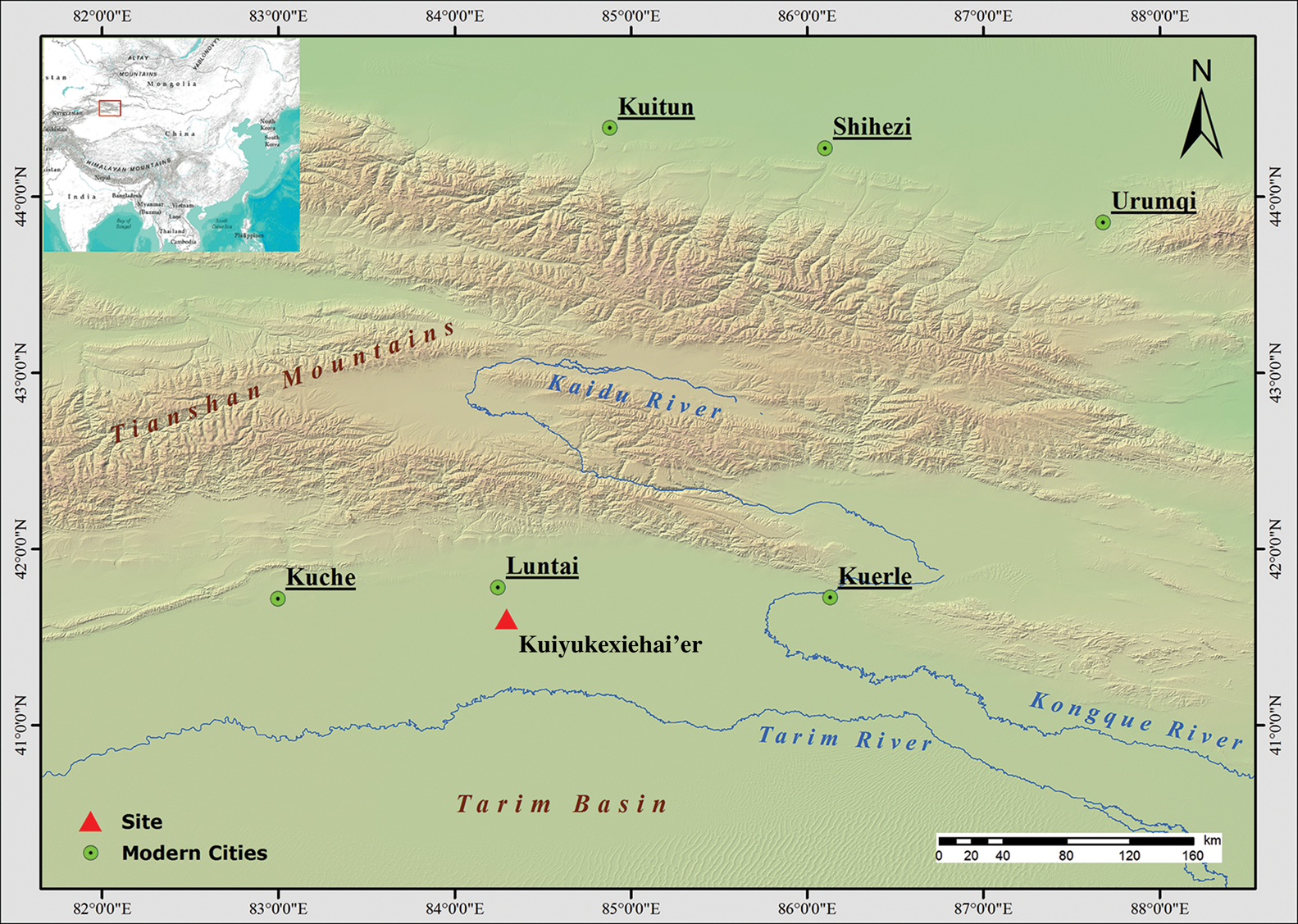
Figure 1. Map showing the location of Kuiyukexiehai'er in the northern Tarim Basin (figure by C. Zhang).
Covering an area of approximately 6ha, Kuiyukexiehai'er is characterised by a large mound platform enclosed by a rounded-rectangular earthen wall (Figure 2). The perimeter of the wall measures approximately 900m. Sitting at the centre of the fortification, the mound platform has a perimeter of 340m and survives to a height of 6.5m. Excavations between 2018 and 2020 were primarily conducted on the mound platform, the north-eastern section of the wall, and around the opening on the southern wall. The work revealed a range of contexts, including wall foundations, pits, ditches, hearths, roads and postholes (Figure 3).
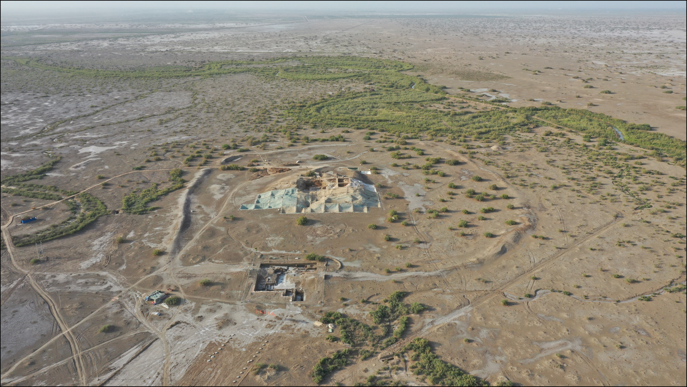
Figure 2. Aerial photo of Kuiyukexiehai'er and its environs (view from south to north) (photograph by Z. Dang).
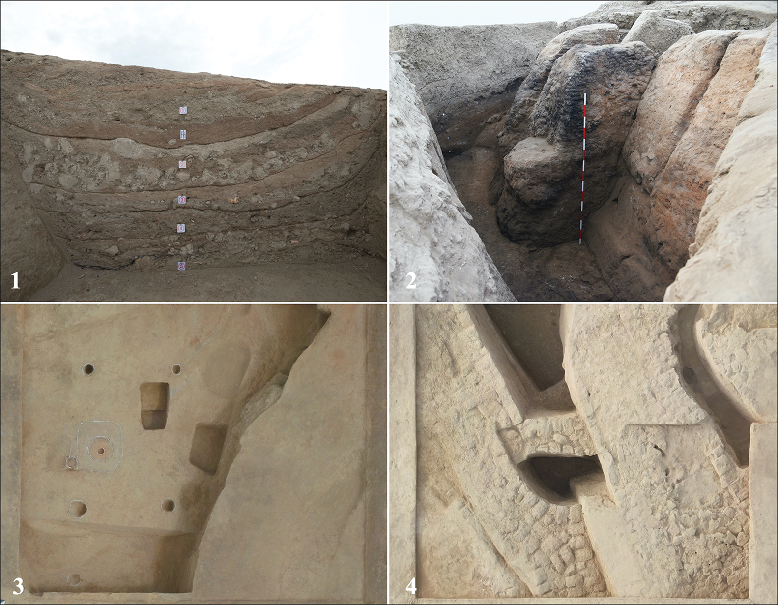
Figure 3. The excavation of Kuiyukexiehai'er: 1) the profile of residential feature F6; 2) traces of burning; 3) residential feature with postholes; 4) mudbrick remains (photographs by Z. Dang and Y. Xu).
Results show that the construction of the wall involved three stages. The innermost, earliest portion of the wall, with a height of around 1m, was built using sandy materials and silt. The main body of the wall, which survives to a height of approximately 5m, was constructed by piling up silt taken from the moat dug outside the wall. The façade of the wall was later refurbished and maintained. Cultural deposits from within the walled enclosure comprise nine layers (counting from the top), of which the fifth and sixth layers were contemporaneous with the occupation of Kuiyukexiehai'er. The bottom two layers were earlier than the main body of the wall (the seventh layer). Mudbricks of varying sizes were used to construct architectural structures on and around the mound platform. The bottom edges of the platform were covered by tamarisk branches and earth to form sloping ramparts.
AMS radiocarbon dating of animal, plant and charcoal remains suggest that Kuiyukexiehai'er was occupied between the eighth century BC and the first century AD (Figure 4). Alongside the style of artefacts, the occupation sequence can be roughly divided into four phases. The earliest human activities occurred c. 770–550 BC (Phase I), during which the innermost portion of the wall was built. The main body of the wall, the moat, and early residential structures on the mound platform were formed in Phase II (c. 550–400 BC). Phase III (c. 400–150 BC) saw the elevation and refurbishment of the wall, widening of the moat and extension of the mound platform. Kuiyukexiehai'er declined in Phase IV (c. 150 BC–AD 80) and was eventually abandoned. Future dating and radiocarbon modelling, however, may improve the precision of this chronology.
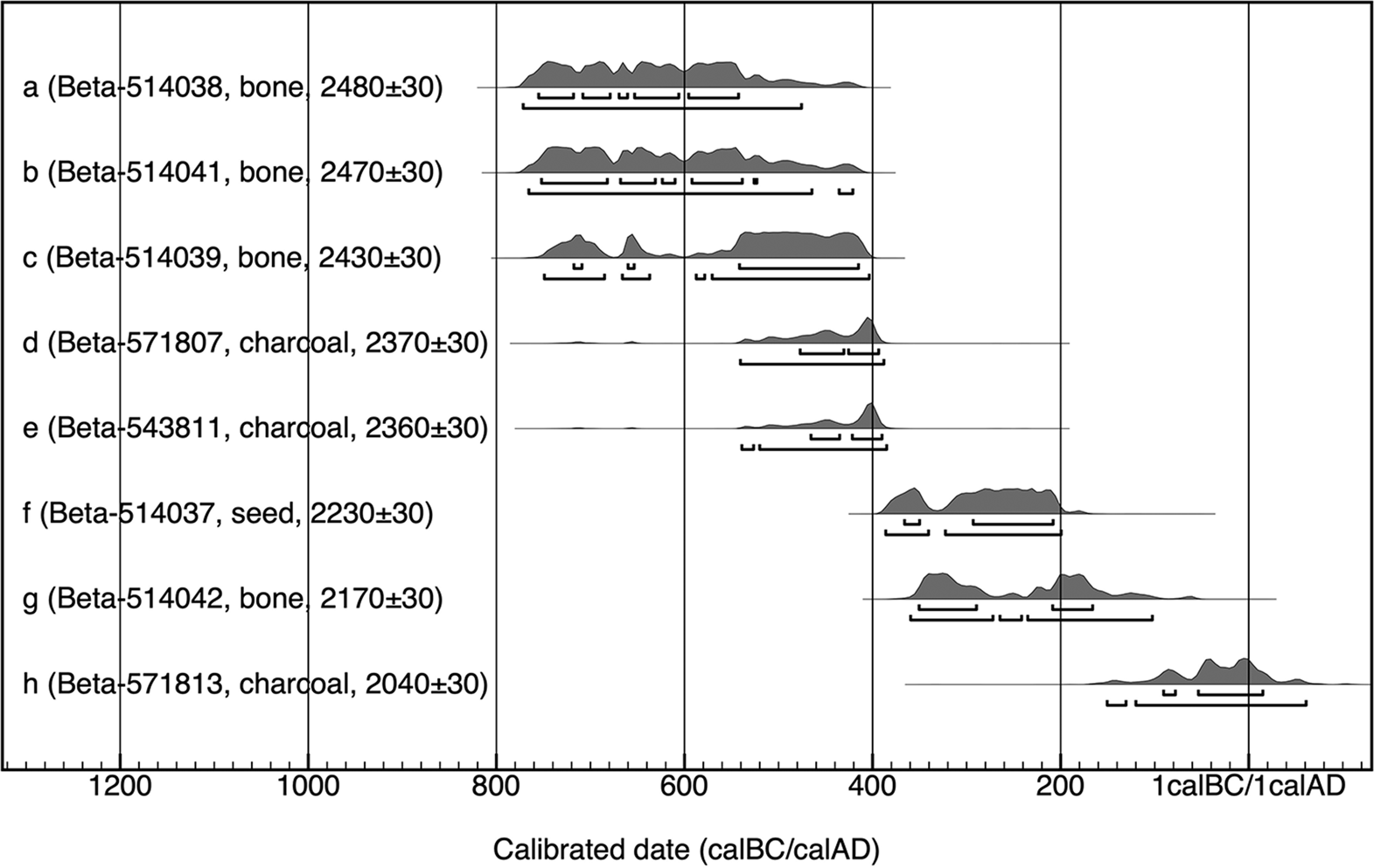
Figure 4. Direct radiocarbon dates for Kuiyukexiehai'er. Conventional radiocarbon ages were generated by Beta Analytic and calibrated in OxCal v4.4 (Bronk Ramsey Reference Bronk Ramsey2009) using the IntCal20 calibration curve (Reimer et al. Reference Reimer2020). Samples a–c and e–g were from the wall; samples d and h were from the mound platform (figure by C. Zhang).
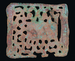
A large quantity of ceramic, metal, lithic, bone and wooden artefacts, exhibiting diverse cultural elements, were recovered from the mound platform and the southern wall (Figure 5). The oracle bone fashioned from caprine scapula, for example, is of a type commonly used for divination in Bronze Age societies in the Yellow River Valley (Flad Reference Flad2008). The spouted jars resemble those associated with the Chawuhu Culture (c. 1000–400 BC), located in almost the same region (Chen & Hiebert Reference Chen and Hiebert1995). The buckles and moulds with animal motifs also exhibit steppe-tradition styles.
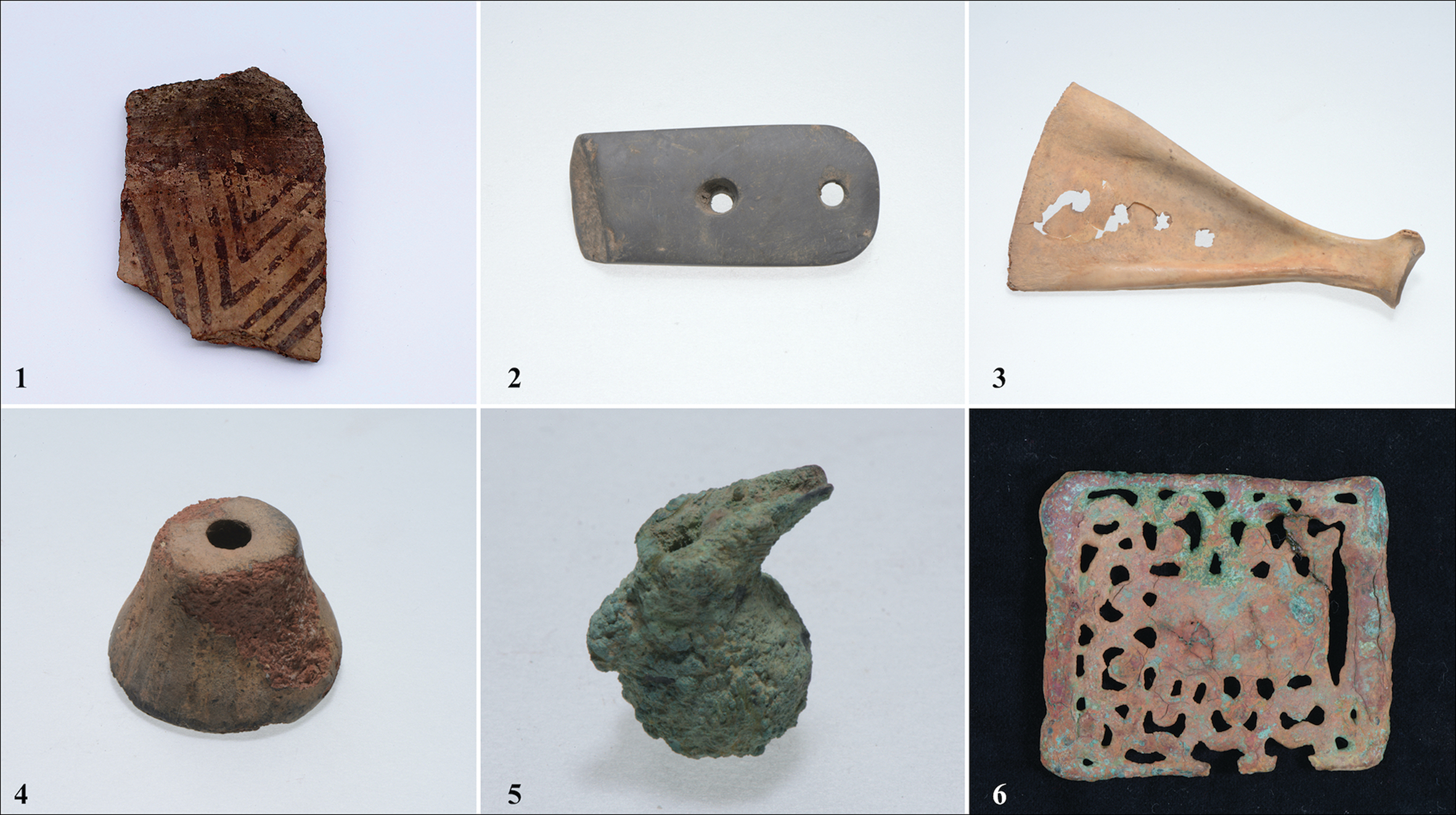
Figure 5. Examples of artefacts from Kuiyukexiehai'er: 1) painted ceramic sherd; 2) whetstone; 3) oracle bone; 4) ceramic spindle whorl; 5. bronze jar; 6. bronze plate (photographs by Z. Dang and Y. Xu).
Preliminary analysis of animal and plant remains shows that domestic animals (e.g. caprines, cattle and horses) and crops, such as naked barley (Hordeum vulgare var. coeleste), foxtail millet (Setaria italica), broomcorn millet (Panicum miliaceum) and wheat (Triticum aestivum), played dominant roles in local subsistence, suggesting that the residents at Kuiyukexiehai'er may have employed an agro-pastoral economy (Figure 6).
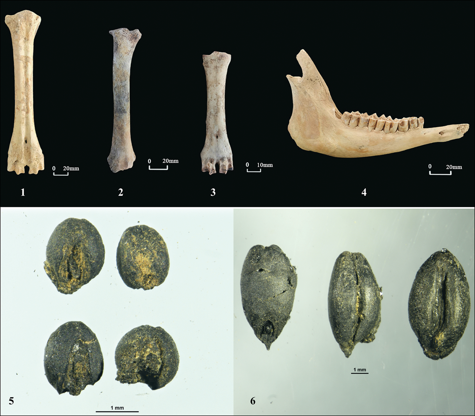
Figure 6. Examples of animal and plant remains from Kuiyukexiehai'er: 1) cattle; 2–4) caprines; 5) foxtail millet (Setaria italica); 6) naked barley (Hordeum vulgare var. coeleste) (photographs by Y. Li and D. Tian).
Significance and future works
Excavations in the Tarim Basin over the past decades—particularly around the northern edge of the region—have focused predominantly on cemeteries (Chen & Hiebert Reference Chen and Hiebert1995). This approach prevents a more holistic understanding of the evolution of civilisations in the Basin prior to the westward expansion of the Han Dynasty in the first century BC and the formalisation of exchange along the Silk Road. Fieldwork results from Kuiyukexiehai'er not only demonstrate the potential connection of its residents with the Chawuhu Culture, but also attest to early urbanism and the practice of agro-pastoral subsistence economy in the northern Tarim Basin in the mid-first millennium BC. The project contributes to ongoing discussions on ancient economic, cultural and social developments south of the Tianshan Mountains.
In the coming years, the project will focus on understanding functional divisions of the walled enclosure, the relationships between the site and neighbouring settlements and cemeteries, and the agency behind the various developments that led to early urbanisation in the Tarim Basin. Multidisciplinary research will also continue to reveal insights into human exploitation of natural resources, craft production, social organisation and environmental conditions during the occupation of Kuiyukexiehai'er.
Funding statement
This research forms part of the Archaeology of China project, which is supported by the National Cultural Heritage Administration of China.


