


Introduction
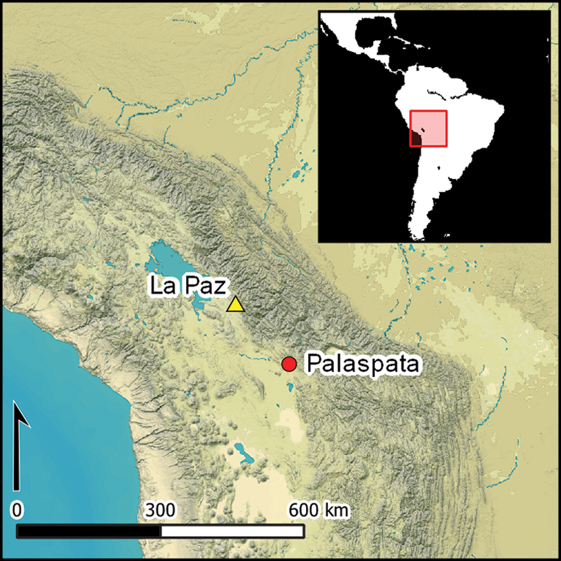
Originating near the south-eastern shore of Lake Titicaca in the Bolivian Andes of South America, Tiwanaku is a pre-Inka Andean civilisation that has fascinated scholars for generations (e.g. Kolata & Ponce Sanginés Reference Kolata, Ponce Sanginés. and Kolata2003). The Tiwanaku state developed from a sedentary agricultural village into a large city with supraregional political organisation during the second half of the first millennium AD (Albarracin-Jordan Reference Albarracin-Jordan and Kolata2003; Janusek Reference Janusek2008). Its ceremonial core comprised a series of monumental, terraced temples constructed with large carved stones (Stanish Reference Stanish2003; Vranich Reference Vranich2020). Greatly affected by looting during colonial times, early scholars positioned Tiwanaku as a ceremonial centre of congregation and religious proselytization (Bennett Reference Bennett1936; Mason Reference Mason1957). Subsequent interpretations, based on research in its hinterland, emphasise how agropastoral intensification organised by political hierarchy and vertical bureaucracy sustained this emerging state (Ponce Sanginés Reference Ponce Sanginés1972; Kolata Reference Kolata1993), while counter-narratives stress the decentralised and autonomous nature of Lake Titicaca’s agropastoral systems as well as the loose integration of households and settlements in the core and periphery (Erickson Reference Erickson and Lentz2000; Janusek Reference Janusek2004). Alternative propositions, based on ethnographic analogies, advocate for the strategic role that Tiwanaku had in managing emergent commerce and inter-regional interaction (Núñez & Dillehay Reference Núñez and Dillehay.1995; Browman Reference Browman and Manzanilla1997), as well as the segmentary and multiethnic nature of this complex Andean political organisation (Albarracin-Jordan Reference Albarracin-Jordan and Kolata2003; Goldstein Reference Goldstein2015). As many of these perspectives contrast strongly with each other, understanding of Tiwanaku has arguably become mired in interpretative fluidity (Vranich Reference Vranich and Young-Sańchez2009).
Despite differing opinions about the nature of Tiwanaku’s political organisation, its size, layout, complexity and labour investment strongly imply that it constituted a state-level sociopolitical system (Stanish Reference Stanish2003). Tiwanaku stone sculptures and polychrome ceramics bear a distinctive iconographic style indicative of religious, economic and political influence (Bennett Reference Bennett1936; Villanueva Criales Reference Villanueva Criales2024). Beyond the nuclear site, the Tiwanaku style is widely distributed over much of the south-central Andes (Berenguer Reference Berenguer2000; Isbell et al. Reference Isbell, Uribe, Tiballi and Zegarra.2018). While state control around Lake Titicaca was evident, the nature of its influence beyond is variable (Higueras Reference Higueras2001; Stanish et al. Reference Stanish, de la Vega, Moseley, Williams, Chávez J., Vining and LaFavre.2010; Albarracin-Jordan et al. Reference Albarracin-Jordan, Capriles and Miller.2014; Delaere et al. Reference Delaere, Capriles and Stanish.2019) (Figure 1). For instance, the intentional establishment of western highland Tiwanaku colonies in the Moquegua Valley of southern Peru is verified by clear stylistic discontinuities from previous local settlement patterns, residential construction and pottery manufacture as well as by the identification of highland migrants in burials through isotopic and non-metric analyses (Knudson et al. Reference Knudson, Price, Buikstra and Blom2004; Owen Reference Owen2005; Goldstein Reference Goldstein2006). Additionally, a large, terraced multiplatform temple emulating those at Tiwanaku has been documented at the site of Omo M10 in Moquegua (Goldstein Reference Goldstein1993; Goldstein & Sitek Reference Goldstein and Sitek.2018).

Figure 1. Study area showing the location of Tiwanaku, Omo-Moquegua and Palaspata in relation to the distribution of Tiwanaku-related sites including those with diagnostic artefacts based on multiple sources (figure by authors).
While Tiwanaku sites in the Moquegua Valley seem to have focused on agricultural production and the provisioning of maize, in other regions such as the Azapa Valley, the Tiwanaku presence is assumed to be indirect and possibly mediated by local elites (Korpisaari et al. Reference Korpisaari, Oinonen and Chacama.2014; Muñoz Ovalle Reference MuÑoz Ovalle2019). Similarly, in San Pedro de Atacama, in northern Chile, the influence of Tiwanaku largely manifests in the form of imported prestige goods and ritual paraphernalia (Uribe et al. Reference Uribe, Santana-Sagredo, Maturana, Flores and Agüero.2016; Horta et al. Reference Horta, Paulinyi, Santander and Echeverría.2020). Much less is known about how Tiwanaku expanded towards the southern highlands and eastern valleys (Chávez Quispe & Alconini Reference Chávez Quispe, Alconini. and Alconini2016; Llanque & Llanque Reference Llanque and Llanque.2024). While some scholars have argued that Tiwanaku’s influence in Cochabamba and other eastern inter-Andean valleys was mostly indirect and mediated by local societies, there is also evidence—including the development of a derivative style and the enlargement of various mound sites—suggesting direct integration (Byrne Caballero Reference Byrne Caballero1984; Sánchez Canedo Reference Sánchez Canedo2008; Anderson Reference Anderson, Vranich and Stanish2013; Döllerer Reference Döllerer2013).
Evidently, the political strategies engaged by Tiwanaku during its expansion beyond Lake Titicaca varied across regions and over time depending on various factors and contingencies (Stanish et al. Reference Stanish, de la Vega, Moseley, Williams, Chávez J., Vining and LaFavre.2010; Smith & Janusek Reference Smith and Janusek.2014; Goldstein Reference Goldstein2015; Williams et al. Reference Williams, Sharratt, Banikazemi, Roddick, Koons, Gabler and Vance.2023). Ranging from imperialist expansion to indirect political influence, a focus on the materialisation of institutional change could aid in reconstructing past sociopolitical dynamics (Tantaleán Reference Tantaleán2020). This article seeks to improve our understanding of Tiwanaku’s expansion strategies into the southern highlands and eastern valleys by reporting recent archaeological research conducted at the site of Palaspata in the Bolivian highlands.
Road networks to the east
The main colonial and republican roads in the Bolivian highlands largely overlap with the Qhapacñan or Inka road system (Hyslop Reference Hyslop1984; Pärssinen et al. Reference Pärssinen, Kesseli and Faldín.2010). Connecting the cities of La Paz, Oruro and Cochabamba since at least the late 1600s, the modern highway was formalised during the second half of the twentieth century AD. The roads connecting these three towns intersect near the modern communities of Cayhuasi and Ocotavi, which are separated by the Cayhuasi River that eventually drains into the Oronco plain to the north of the city of Oruro. Cayhuasi and a major gas pipeline are located north of the river while Ocotavi and the modern road follow the southern or left bank of the river. Despite its status as one of the major roads in the Bolivian highway system, the road remained a single carriageway until the last decade. As part of the planned expansion into a double-lane highway, a socioenvironmental impact assessment prompted a thorough inventory of archaeological sites in the immediate vicinity (Geo Delta Reference Geo Delta2014). During this assessment, Cayhuasi was associated with a perimeter that extends across both sides of the river comprising approximately 194ha (Geo Delta Reference Geo Delta2014). Likewise, the construction of vehicle weighbridges at different points along the renovated highway involved the identification and prevention of impacts to this cultural heritage (Calla Maldonado Reference Calla Maldonado2021).
Previously, the only archaeological investigation at Cayhuasi was carried out by the Swedish archaeologist Stig Rydén in 1952 (Rydén Reference Rydén1959). Rydén explored the area east of Cayhuasi (Figure 2), reporting a large scatter of Tiwanaku ceramics between two clusters of burial towers (chullpa). Three pits were excavated, at roughly 100m intervals, to determine the depth and extent of occupation as well as any association with the burial towers. Pit 1, situated near the middle of the site, provided 2m of stratigraphy dominated by Tiwanaku-style pottery sherds and camelid bones but lacking any features apart from a poorly preserved infant burial. Pit 2 also largely comprised Tiwanaku ceramics and camelid remains, while pit 3 contained the remains of at least 14 complete ceramic jars capped by black-on-orange decorated bowls and was interpreted as a libation area associated with the eastern cluster of burial towers. Stratigraphy in this sector was shallower and largely verified that the burial towers were associated with an occupation that postdated Tiwanaku. Rydén (Reference Rydén1959) sketched the surface distribution of Tiwanaku ceramics in two areas separated by a small ravine (Figure 2). The resulting surface covered approximately 1.25ha, but part of the site seems to have been eroded by the river. While Rydén did cross the river to take a photograph of the burial towers, he did not notice that the site extended beyond the shore towards the south and therefore underestimated its size and complexity.
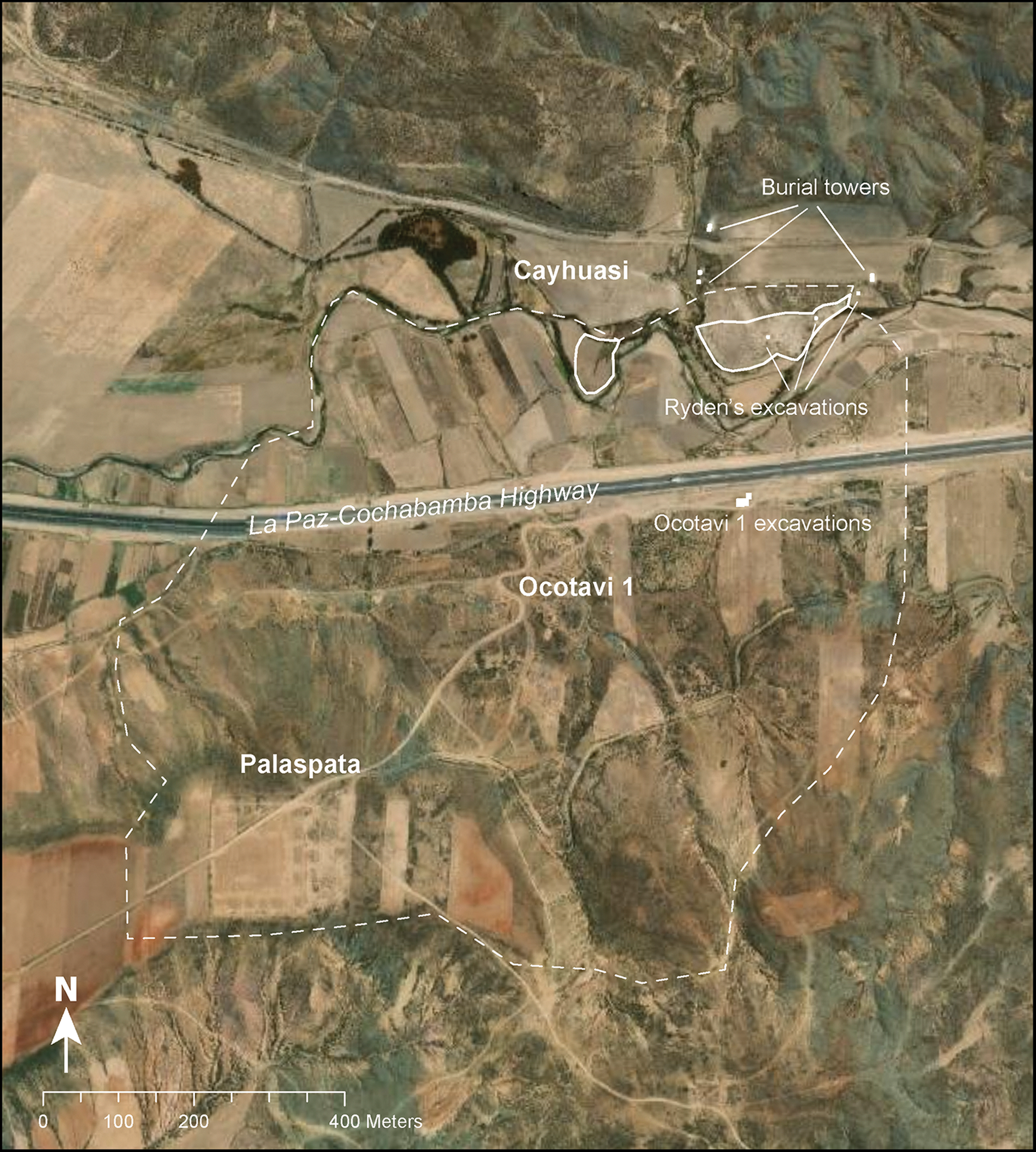
Figure 2. Detailed view of the study site including the approximate location of Ryden’s 1952 excavations and projected boundaries of the Cayhuasi site (solid white line), the 2021 Ocotavi 1 excavation area, the Palaspata temple and the revised extent of the Tiwanaku occupation of the settlement (dashed white line) (figure by authors).
Recent research in Ocotavi 1
Ocotavi 1 is located approximately 170m south of the Cayhuasi River and Rydén’s (Reference Rydén1959) research area. During the archaeological impact assessment, systematic collections and excavations were conducted over 92.2m2 with a major focus on 70 1m2 units within a 10 × 70m grid in the centre of a flat platform (Calla Maldonado Reference Calla Maldonado2021). Stratified deposits including residential middens, use surfaces and burials were documented. While most strata were associated with a Tiwanaku-period occupation, both underlaying and overlying deposits were also noted, suggesting a prolonged settlement chronology.
A group of buried cists delimited by large circles of cobbles placed near their top contained three seated and flexed individuals. Two adults, one male and one female, were aged between 30 and 35 years, the third individual was slightly younger at 20–25 years but biological sex could not be determined. Two of these individuals had elongated cranial modification. The youngest individual was buried in the foetal position and the matrix around them contained strands of an organic fabric and small particles of copper decomposed by humidity. They were also accompanied by a complete Tiwanaku-style bowl decorated with a black-on-orange wavy line design, characteristic of ceramics associated with the Classic Tiwanaku style, but also present in Tiwanaku ceramics from the Cochabamba valleys.
Tiwanaku-style polychrome ceramics including fragments of keru cups, flared bowls and carinated basins were ubiquitous in excavated deposits (Figure 3). Sherds from utilitarian wares such as cooking pots and storage jars were also abundant. Less common ceramics include styles from the eastern inter-Andean valleys such as Tricolor Cochapampa, Sauces and Tupuraya (Döllerer & Sanzetenea Rocha Reference Döllerer and Sanzetenea Rocha2011). Lithic materials were abundant, consisting mainly of projectile points, a variety of scrapers and retouched flakes—some of which correspond to tool manufacture debris—and large lithic hoes, mostly manufactured in black basalt and grey quartzite. At least one blue sodalite bead was recovered as well as some obsidian flakes.
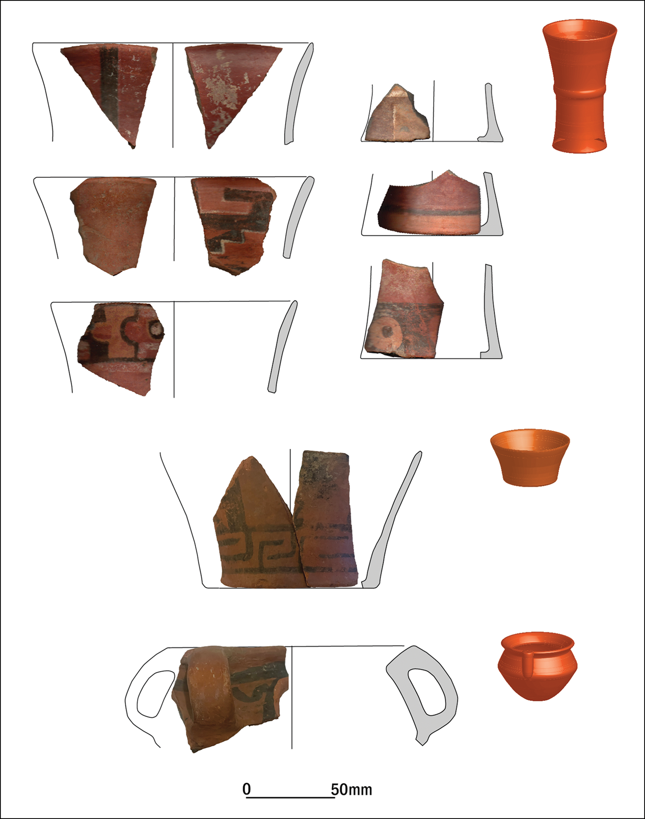
Figure 3. Examples of Tiwanaku-style ceramic sherds recovered from the surface and excavations in Ocotavi 1 (figure by authors).
Zooarchaeological analysis of 2092 bone specimens revealed an unsurprising dominance of camelid bones but also some additional taxa including small and middle-sized rodents. Single specimens of killifish, toad, coot and deer suggest potential exploitation of wild resources from aquatic environments. A few bone tools were also retrieved, including a scraper made from a camelid mandible and awls made from long bone shafts comparable to bone industries from other highland sites including Chiripa, Tiwanaku and Iroco (Moore Reference Moore, Choyke and O’Connor2013; Capriles Reference Capriles2014).
To refine the chronology of the site, charcoal samples collected in situ were selected for radiocarbon dating (Table 1). The resulting 14 dates were calibrated and organised in a sequence using OxCal 4.4 (Bronk Ramsey Reference Bronk Ramsey2021) and the SHCal20 southern hemisphere calibration curve (Hogg et al. Reference Hogg2020) (Figure 4). The earliest sample of the sequence dates to cal AD 480 (421–539 at 95.4% probability), for the Formative occupation of the settlement. The most intensive occupation of the site including the Tiwanaku component began c. cal AD 630 (566–668, at 95.4% probability) and ended approximately 320 years later around cal AD 950 (891–1027, at 95.4% probability). A post-Tiwanaku occupation was also reported and dated to c. cal AD 1240 (1221–1268, at 95.4% probability).
Table 1. Radiocarbon dates from Ocotavi 1, organised and analysed in a Bayesian sequence that incorporates stratigraphic information in OxCal 4.4 (Bronk Ramsey Reference Bronk Ramsey2021) using the SHCal20 Southern Hemisphere calibration curve (Hogg et al. Reference Hogg2020).
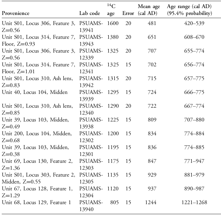
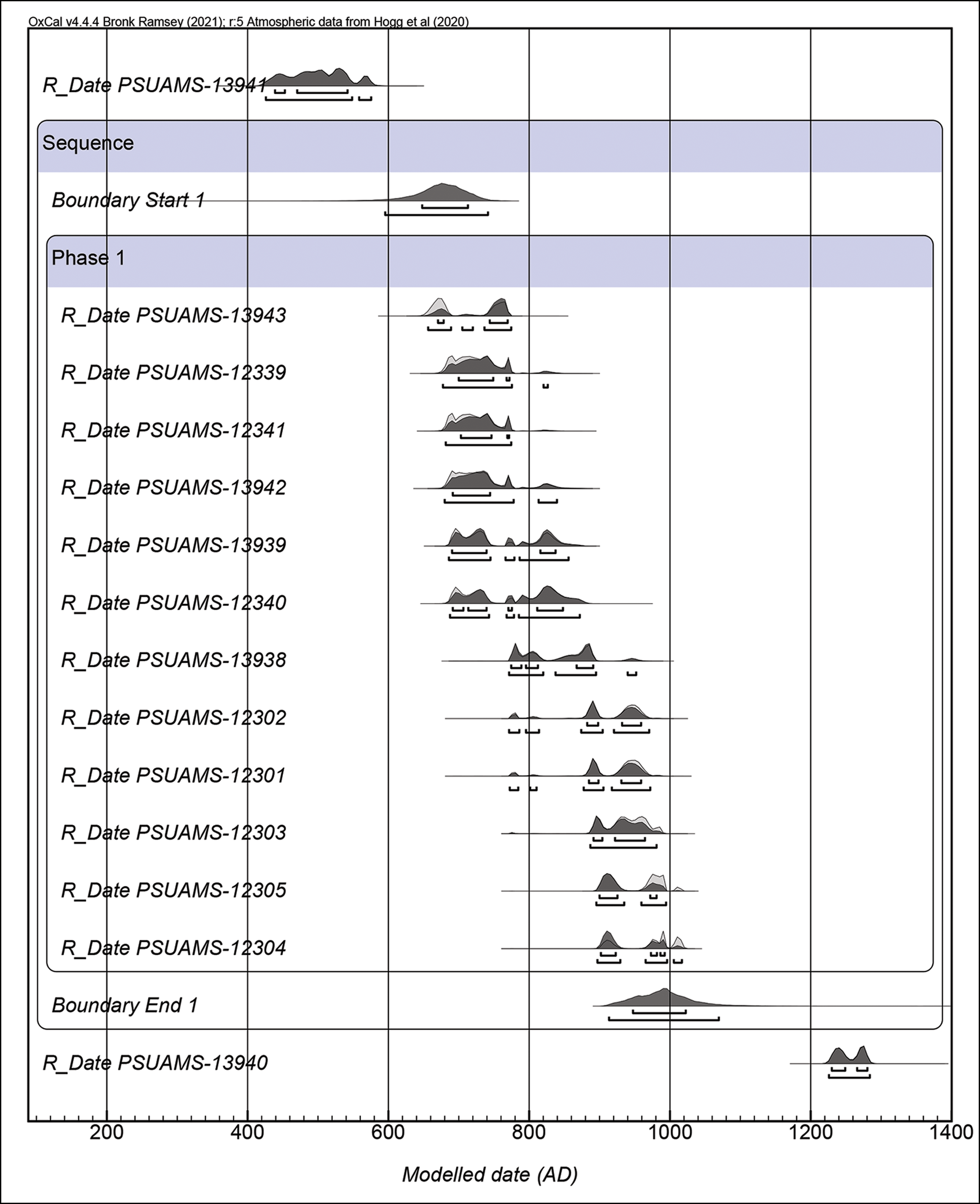
Figure 4. Calibrated radiocarbon dates from Ocotavi 1 organised chronologically, including a single occupation phase corresponding to the Tiwanaku expansion (figure by authors).
To further improve the delimitation of the site and identify a suitable location for a weighbridge, an assessment of the surrounding area was carried out. The site clearly expands through the alluvial plain towards the north at least up to the edge of the current course of the Cayhuasi River. In the foothills and ridge towards the south of the intervening area, scatters of ceramics verify that the site expands uphill. Approximately 50m above the alluvial foothills and on top of the southern ridge plateau, we discovered the remains of a substantial temple complex. Although locally known as Palaspata, this rectangular complex had not been previously recognised archaeologically because it is not observable from the road and the area is sparsely populated.
Palaspata
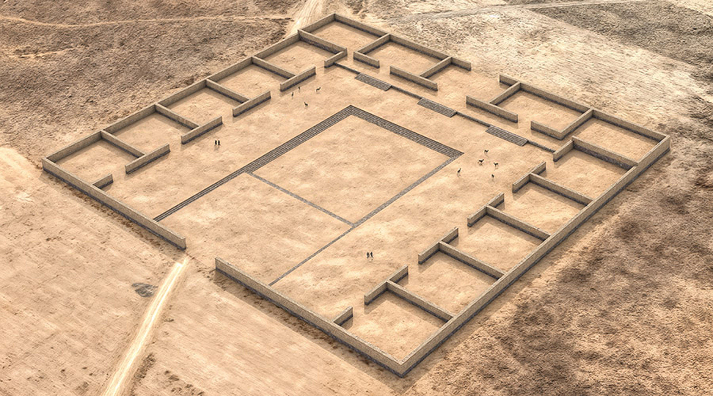
The Palaspata temple complex consists of a semi-quadrangular building orthogonally oriented in relation to the cardinal axis and measuring approximately 125m from east to west and 145m from north to south (Figure 5A). It is composed of 15 modular enclosures arranged around a rectangular courtyard, plaza or kancha, which may have contained a quadrangular sunken court (Figure 5B). The modules range in size between 358 and 595m2 and could have contained additional rooms and divisions. The main entrance of the temple faces west in alignment with the solar equinox. Currently, a local trail crosses the building, intersecting its western and northern walls. The site and its surroundings have also been affected by use of the land for agriculture and grazing.
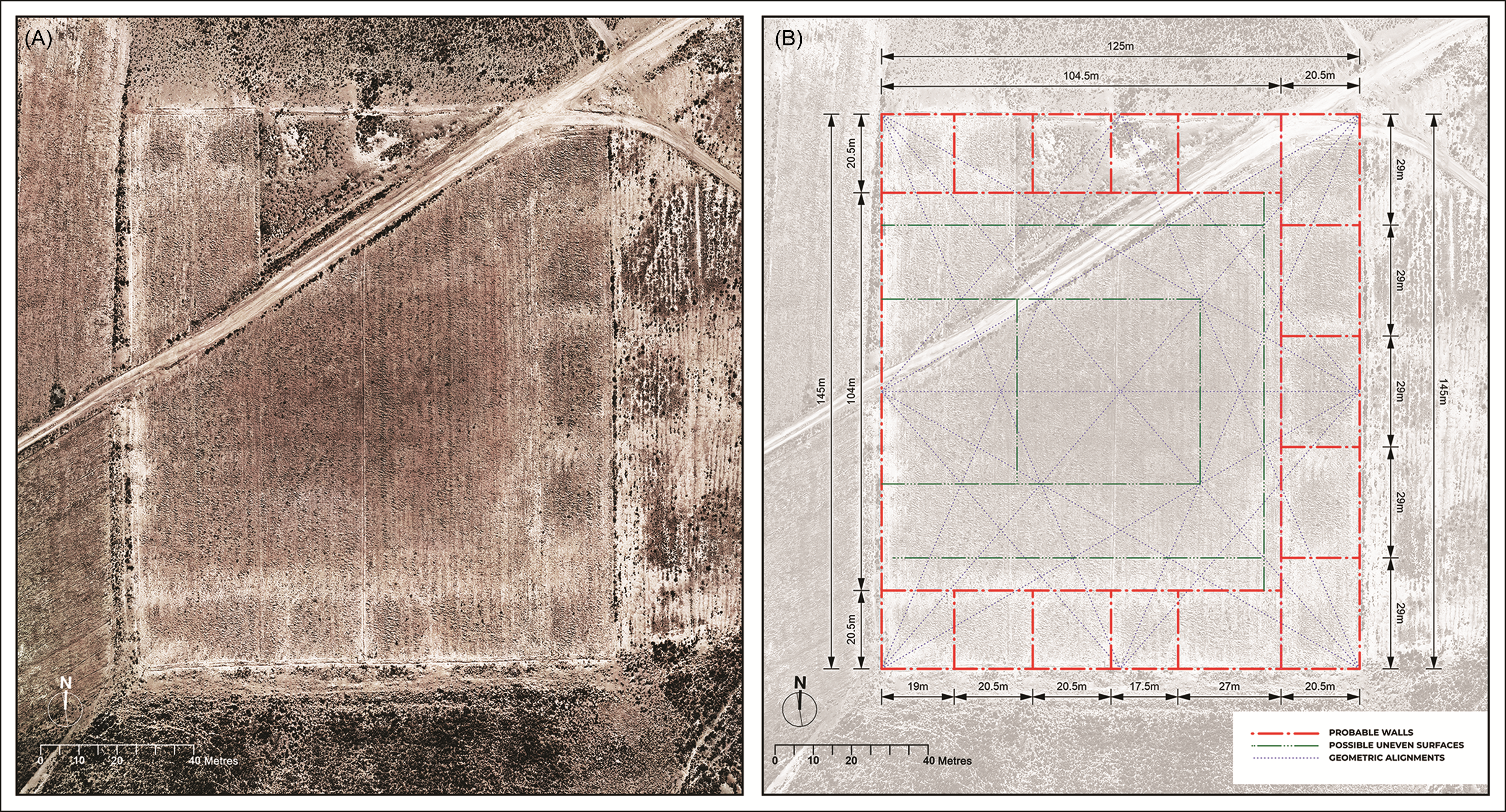
Figure 5. The Palaspata temple including A) ortho-mosaic of recent aerial images, and B) a composite filtered image highlighting chromatic anomalies and superimposed by grid and auxiliary lines to segment its geometry (figure by authors).
The north and south boundaries of the structure are constrained by the extent of the ridge, which immediately drops down in both directions. Slight changes in elevation and vegetation from the otherwise flat terrain make the structure distinguishable in the field. Outlines of the walls are visible as subtle topographic changes in rock density and soil compaction. The perimeter wall is probably the most evident feature as it is outlined by red sandstone slabs and white quartzite boulders, measuring on average 0.65 × 0.25m. It is uncertain where these slabs came from, but many seem carved and polished. Unfortunately, countless stones have been removed to facilitate agricultural ploughing and are reused in nearby buildings, a practice also observed at other archaeological sites in the region (Pärssinen et al. Reference Pärssinen, Kesseli and Faldín.2010). Two large accumulations of these stones, measuring approximately 4m in diameter, are observed near the north-west and south-east corners of the temple (Figure 6). The walls, all of which have collapsed, presumably combined stone masonry with earthen partitions of adobe or tapia. The walls of the interior rooms are less apparent, but a few alignments of rocks are visible. Given their size, it is unlikely that the enclosures were roofed. The massive scale of the building is apparent in a hypothetical reconstruction rendered with 3m-tall walls (Figure 7).
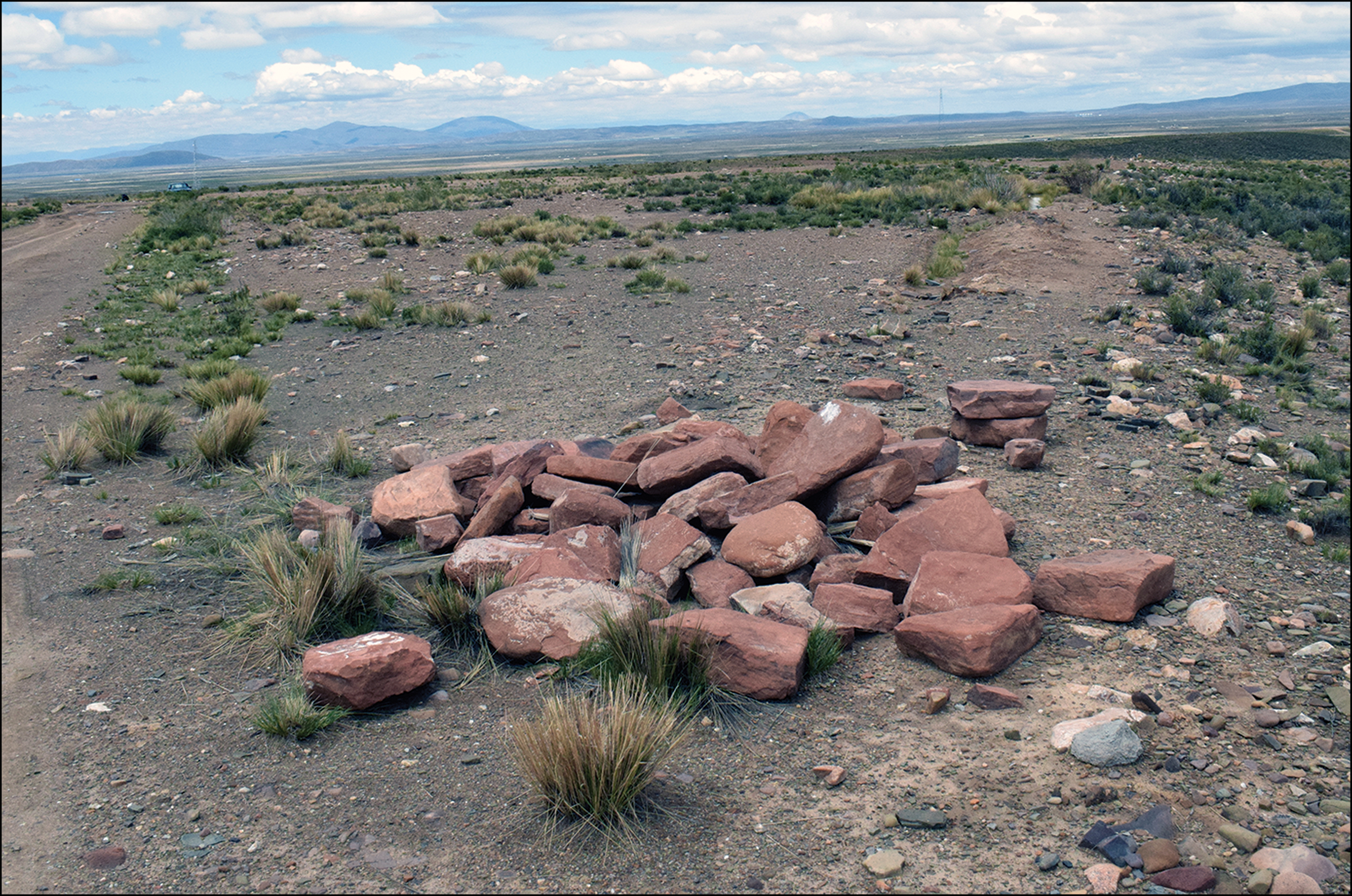
Figure 6. Accumulation of carved red sandstone near the north-western corner of Palaspata. Also notice the modern pathway to the left and the alignment corresponding to the northern perimeter wall to the right (figure by authors).

Figure 7. Isometric reconstruction of the Palaspata temple rendered with 3m-tall walls (figure by authors).
We observed moderate densities of artefacts in the interior of the building with the largest concentrations inside the modular enclosures. Ceramic fragments of keru cups, flared bowls, jars and incense burners made with high-quality pastes and decorated with Tiwanaku iconography are common, but some sherds of Yampara, Tupuraya, Mojocoya and other decorative styles are also present and suggest interaction with the inter-Andean valleys. A few fragments of black-on-red Carangas pottery were also observed, particularly near a possible collapsed post-Tiwanaku funerary tower near the southern edge of the ridge. Lithic and bone fragments were exposed on the surface of the site including large fragments of camelid ribs, pelvis and long bones. Fragments of turquoise stone and at least one Oliva peruviana marine shell were also observed, suggesting connections with the Atacama Desert and the Pacific Ocean. The presence of these exposed materials confirms that the site is actively undergoing erosion.
The ceremonial complex was terraced and levelled but the building is slightly sloped from the west to the east. Except for two roughly rectangular concentrations of artefacts, the plateau continues largely absent of additional cultural features towards the west. In contrast, at least three additional terraces with dense concentrations of artefacts and features are found towards the east, including a few eroding slab tombs. Ritual and domestic activities occurred across the eastern terraces and slopes towards the north. The ceramic material across these areas is consistent with that distributed in the alluvial plain and mostly corresponds to high-quality Tiwanaku-style decorated wares. In our estimation, Cayhuasi, Ocotavi 1 and Palaspata likely encompass a single multifunctional settlement that extended for at least 75ha.
Discussion: gateway to the east
In the Andes, the construction of monumental temples, open plazas and large reticular complexes was an effective means for expanding societies to institutionalise their control over surrounding populations and territories (Jennings & Craig Reference Jennings and Craig.2001; Smith Reference Smith2016; Jennings & Swenson Reference Jennings and Swenson.2018). For instance, D-shaped temples were a distinctive institution created by the Wari empire potentially for the performance of public rituals with the goal of reproducing state authority (Reid Reference Reid2023). Similarly, the contemporaneous Tiwanaku state built rectangular, terraced platform temples to expand its hegemony, and various examples are found on the shores of Lake Titicaca such as at Lukurmata, Chucuperka and Chucaripupata (Bennett Reference Bennett1936; Ponce Sanginés Reference Ponce Sanginés1972; Seddon Reference Seddon, Stanish, Cohen and Aldenderfer2005). The Omo M10 temple in the distant Moquegua Valley also demonstrates how this building type was an effective, if not necessary, instrument of conquest and expansion (Goldstein & Sitek Reference Goldstein and Sitek.2018). Built infrastructure not only served concrete economic, political and social roles, but by means of astronomical and geographic alignments, ultimately helped to dominate the sacred landscape (Saintenoy et al. Reference Saintenoy, González-García and Fernandez.2019; Cruz et al. Reference Cruz, Joffre and Vacher.2023).
Tiwanaku was not only a powerful religious centre, but also a centripetal axis for supraregional commerce and interaction (Núñez & Dillehay Reference Núñez and Dillehay.1995; Browman Reference Browman and Manzanilla1997). Towards the southern highlands, key Tiwanaku sites such Khonkho Wankane (Smith Reference Smith2016), Iruhito (Smith & Janusek Reference Smith and Janusek.2014), Cerro Chijcha (Smith et al. Reference Smith, Pérez Arias, Pérez Arias and Flores Pérez.2014), Pajcha Pata (Pärssinen Reference Pärssinen2001), Jirappi Alto (Salame Reference Salame2019), Huancarani 2 (Ponce Sanginés Reference Ponce Sanginés1972), Jachakala (Bermann & Estévez Castillo Reference Bermann and Estévez Castillo1993), Iroco KCH22 (Capriles Reference Capriles2014) and Condor Chinoca (Gyarmati & Condarco Castellón Reference Gyarmati and Condarco CastellÓn2014), not only facilitated local hegemony, but were part of a broader network of economic, political and religious interconnectivity enabled by the use of llama caravans. Located at key intersections for the transport and movement of people and goods, the distribution of these sites follows the Desaguadero River drainage as well as the western face of the eastern Cordillera of the Andes, facilitating access to specific resources and inter-regional trade. Nevertheless, terraced platform temples outside the Lake Titicaca basin are scarce, which limits our understanding of Tiwanaku’s areas of influence and connection on an inter-regional scale. One notable exception is Conchamarka near Yaco, where an architectural complex containing carved stone blocks was built on top of a rocky outcrop (Chávez Quispe Reference Chávez Quispe, Portugal Loayza and Chávez Quispe2018).
Towards the eastern valleys of Cochabamba, Tiwanaku’s presence has been mostly documented in habitational mounds and cemeteries (Byrne Caballero Reference Byrne Caballero1984). Although many of these sites have been destroyed or severely damaged by urban and agricultural development, a few excavated sites such as Tupuraya (Rydén Reference Rydén1959), Piñami (Céspedes Paz Reference Céspedes Paz2000; Anderson Reference Anderson2019), Arani (Bennett Reference Bennett1936) and Pirque Alto (McAndrews Reference McAndrews2009) signal a strong Tiwanaku influence. Moreover, the ceramic style reported from these sites is often described as a locally manufactured derivation of Tiwanaku characterised by a few decorative variants and distinct shape preferences (Bennett Reference Bennett1936; Anderson Reference Anderson, Vranich and Stanish2013). While some scholars have suggested indirect influence of Tiwanaku in the region based on settlement patterns (Higueras Reference Higueras2001; Sánchez Canedo Reference Sánchez Canedo2008), excavations in residential sites such Sierra Mokho reveal that during the period of Tiwanaku influence many sites were substantially expanded into sizeable mounds commanding extensive agricultural landscapes (Döllerer Reference Döllerer2013). Indeed, palaeoethnobotanical evidence verifies that maize from Cochabamba was imported to Tiwanaku and used in ceremonies and feasts (Hastorf et al. Reference Hastorf, Whitehead, Bruno, Wright., Staller, Tykot and Benz2006). Various other prestigious goods such as polychrome vessels, sodalite and possibly hallucinogenic plants travelled to Tiwanaku from the eastern Andes, propelled by llama caravans (Janusek Reference Janusek2008).
The archaeological research from Ocotavi 1 and Palaspata reported here demonstrates the existence of a substantial and complex population centre located in one of the main connecting points between Tiwanaku, the Central Altiplano and the inter-Andean valleys of Cochabamba (Figure 8). The stratigraphy and chronology of Ocotavi 1 verifies a main phase of occupation between cal AD 630 and 950, which largely corresponds to the period associated with the Tiwanaku expansion (Marsh et al. Reference Marsh2023). The Palaspata monumental complex seems to derive from the long tradition of temple construction observed in Lake Titicaca featuring sunken courts enclosed by rectangular rooms and stone-lined terraced platforms such as the Kalasasaya in Tiwanaku and the Omo M10 temple in Moquegua (Vranich Reference Vranich and Young-Sańchez2009; Goldstein & Sitek Reference Goldstein and Sitek.2018; Levine & Stanish Reference Levine, Stanish. and Eeckhout2020). This large, symmetric, modular construction also recalls sites such as Pikillacta, Azangaro and other contemporaneous Wari administrative outposts (McEwan Reference McEwan2009; Tantaleán Reference Tantaleán2020). Given that Palaspata likely functioned as a ritual gateway between two major contrasting ecological and productive regions, the ceremonies it held might have involved sacralising the western-highland to eastern-lowland flows of people and goods while its peripheral enclosures functioned for storing, tallying and ultimately managing these flows. In this regard, Palaspata was relationally comparable with Paria, a later major Inka administrative hub or tambo located just 17km towards the south (Hyslop Reference Hyslop1984; Pärssinen et al. Reference Pärssinen, Kesseli and Faldín.2010; Gyarmati & Condarco Castellón Reference Gyarmati and Condarco CastellÓn2014).
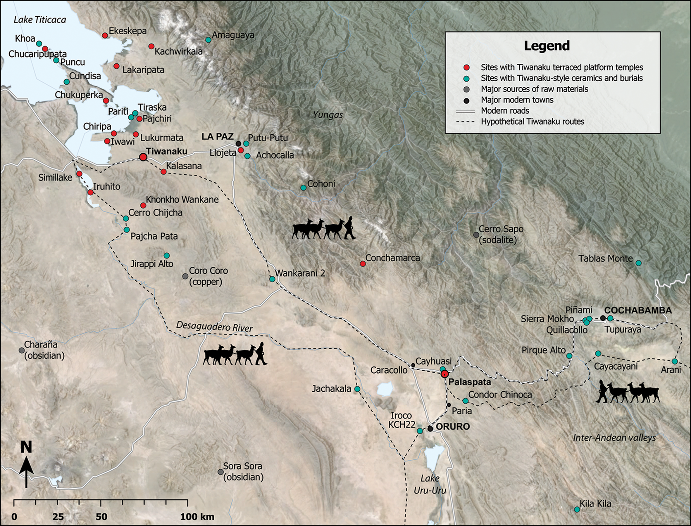
Figure 8. Map showing archaeological sites associated with Tiwanaku occupations (figure by authors).
Conclusions
The research reported here aims to advance our understanding of the specific forms that the expansion of Tiwanaku took. By the middle of the first millennium AD, the southern highlands and the Cochabamba inter-Andean valleys became strongly influenced, if not fully controlled, by the expanding Tiwanaku state. Nevertheless, until now, the physical connectivity among these regions remained unclear. The discovery of Palaspata provides a previously missing connection and nexus not only to corroborate the interconnectivity between these regions but also to realise its strength. While it is likely that local elites interested in profiting from the circulation of goods supported the construction of the site, the investment in infrastructure was also a strategically planned decision from a macroregional polity such as Tiwanaku, which ultimately required such an infrastructural investment to consolidate its geopolitical hegemony. Further fieldwork, dating and analysis of materials from the building itself will help to determine more precisely when the ceremonial complex was built, how it compares to other terraced platform temples in the region and, ultimately, how it was used. Additional research at the site will also help to resolve questions about alternative models of Tiwanaku political strategy. In tandem, more extensive documentation of other settlements in the highlands and eastern valleys should provide a better understanding of the sociopolitical dynamics in the region and how these changed through time.
Acknowledgements
We thank the Bolivian Ministerio de Culturas, Descolonización y Despatriarcalización (particularly Julio Condori Amaru, Carla Flores and Victor Plaza Martínez); the Administradora Boliviana de Carreteras (principally Ludwing Cayo and Juan Ticona); the Bolivian branch of the Sociedad Iberica de Construcciones Eléctricas S.A. (especially Paola Rodas Arano and Jorge Sarmiento Segura); the Gobierno Autónomo Municipal de Caracollo (particularly Dr Justo Ventura Guarayo, Dr José Miguel Condori, Grover Salamanca) and the communities of Ocotavi and Chiarake; as well as María Fernanda Salame, Carla Rodas, Mery Vilelo, Daniela Velazco Arzabe and Claudia Rivera Casanovas from Universidad Mayor de San Andrés, and Brendan Culleton, Alejandra Domic, Sarah Ivory and Laurie Eccles from Pennsylvania State University for their assistance during this investigation. Fieldwork in Ocotavi is reported in Calla Maldonado (Reference Calla Maldonado2025) and additional data are available from the authors upon request.
Funding statement
This research was supported by National Science Foundation awards BCS-2015924 and DEB-2208411.


 Open access