


Introduction
Islands constitute a microcosm for studying the development of human communities in physically isolated but intensely connected environments (Boomert & Bright Reference Boomert and Bright2007; Dawson Reference Dawson2019).
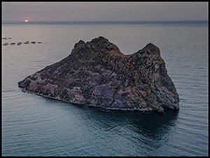
Isla del Fraile is a 6.2ha islet (Figure 1) located off the coast of present-day Águilas, Spain, a town founded after the Roman conquest of the area and strongly transformed in the Augustan period (between c. 45 BC and AD 14). The island was inhabited for many millennia: in Antiquity, it was a centre for the production of salted fish and its last inhabitant was Hugh Pakenham Borthwick, an English spy, in the early twentieth century. Since 2020, an archaeological research project has been studying its terrestrial and underwater heritage. The objectives are to:
• analyse the long-term biographical evolution of the island and to determine settlement patterns on islets during Antiquity;
• study its maritime cultural landscape, evaluating the underwater archaeological contexts associated with the site and to characterise the maritime dynamics that surround it; and
• ascertain the role it played in Late Roman western Mediterranean trading networks.
The Isla del Fraile Project aims to explore maritime connectivity by studying the occupation of small islands in a territory (the Iberian Peninsula) and over time (Late Antiquity)—both aspects are under-represented in previous archaeological research.

Figure 1. Isla del Fraile archaeological site (photograph by J. Rodríguez Pandozi).
Methodological approach
The first step for the analysis of Isla del Fraile and its hinterland was a terrestrial and underwater survey. The main aim of this interconnected approach was to establish whether there was a natural extension of the site in the marine environment (Figure 2). The site is being examined through multidisciplinary methods to provide a context-specific, high-resolution stratigraphic narrative of human occupation in the island. Stratigraphy is analysed both macroscopically, through open-area excavations and architectural analysis of the archaeological structures, and microscopically by means of high-resolution microstratigraphy combining micromorphology, physical-chemical analyses and geochemistry. The material culture is studied in its context, combining a typo-chronological approach with archaeometric methods involving petrographic and residue analysis.

Figure 2. 1) Results of the terrestrial archaeological survey, 2020; 2) Defining marine morphology around Isla del Fraile; 3) Circular underwater survey with divers (non-intrusive methodology) and some finds: Roman bronze jug and African Red Slip ware plate (figure by authors).
Results: characterising the islet's archaeology
The field survey documented the long-term occupation of the area. Material remains extend from the second century BC to the early twentieth century, with a medieval Islamic phase dating from the Almohad Empire in the twelfth and thirteenth centuries AD. The underwater survey complemented the archaeological sequence of the islet, as evidenced by the discovery of prestigious material such as a bronze jug from the Late Republican/Early Imperial period. The fifth century AD is the period of splendour at the site (Figure 3), as shown by the presence of impressive archaeological assemblages and prestigious materials, such as dome mosaics and window crystal sheets (lapis specularis). More than 30 per cent of the products consumed at this time were imported from Africa proconsularis (present-day Tunisia), especially amphorae and fine tableware such as African Red Slip ware. The survey also recorded pools used to produce salted fish, together with net weights and bronze hooks. Residual ceramics of the sixth century AD suggest a possible frequentation in Byzantine times after the conquest of the area by Emperor Justinian.

Figure 3. 1–9) African imports from the fifth century AD; 10 & 11) Construction materials; 12–14) Bronze hook, glass and coticula (figure by A. Quevedo).
During the excavation, six sectors were studied in the northern part of the island, delimited by architectural remains (Figure 4). One of the most complex and data-rich spaces is the room defined in Sector 2. Under its foundations, an abandonment layer is the oldest phase identified in the island dated to the second and first centuries BC.

Figure 4. Excavation in the north sector of the islet (figure by J. Rodríguez Pandozi & A. Quevedo).
Inside the room, built after the third century AD, a thick destruction layer made up of at least eight complete amphorae was found (Figure 4). Its discovery, together with the ceramic plugs and remains of the original contents, allow us to interpret this space as a warehouse in the second half of the fifth century AD. Typological and petrographic analysis shows that most of the amphorae come from various sites in present-day Tunisia (Capelli & Bonifay Reference Capelli, Bonifay, Ferrandes and Pardini2016) together with one of local production (Figure 5). Two of those identified are from the northern region (Keay 27 and 40), three from the workshops of the city of Nabeul (Keay 57) and another three from the Tunisian Sahel (Keay 8B and undetermined, possibly from the workshops of Leptiminus and Moknine). The study of the palaeocontents, still in progress, has revealed that at least the Keay 57 type contained fish sauces. The importation of salted fish to an island site that also produced these goods could indicate that the Isla del Fraile was used as a redistribution centre.

Figure 5. Archaeometric characterisation of the amphorae. 1) Nabeul and other undetermined regions of North Africa (2–4), Crossed polars (1.3 × 1mm) (figure by C. Capelli).
The excavation has made it possible to define the nature and composition of the constructions. The main architectural element of the island is a pair of continuous retaining walls, each 2.37m wide, made with large masonry and abundant lime mortar that adapts to the contours of the lower part of the island. Other constructions, perpendicular to the main retaining wall, define rooms. In the excavated area, the stratigraphic sequence shows that, once the perimeter walls of the room were completed, a large basin covered with opus signinum was placed behind it. The techniques and materials used for its construction suggest the participation of workshops specialising in hydraulic architecture.
Sector 2's complex stratigraphy is a result of a diachronic human occupation and episodes of abandonment of the architectural space. The sequence starts with a clast-supported deposit where Roman Republican artefacts were recovered. Subsequently, combustion structures and occupation debris are stratigraphically associated with the construction and use of the excavated rooms after the first century BC. The site was then abandoned for a relatively long period in which clayey sedimentary crusts formed in a water-saturated environment during intense rainfall periods. Over this, there is a thick layer of dumped calcareous construction materials (mostly fragments of opus signinum pavements). Again, silt and clayey laminae are found on which purplish clay-beaten floors, interspersed with occupation deposits, correspond to the last occupations of the rooms. The last of these floors is the location of the above-mentioned destruction layer with the complete amphorae (Figure 6).

Figure 6. Stratigraphic section of Sector 2 (figure by M. Gutiérrez-Rodríguez).
Conclusion
Terrestrial and underwater archaeological research shows that Isla del Fraile has been a site of human occupation linked to the exploitation of sea resources for more than 2000 years, dating back to at least the first century BC. During the fourth and fifth centuries AD, an impressive urban complex was created on the island resulting in a commercial centre with strong connections to North Africa. The deliberate occupation of an islet off the coast, together with the richness of the archaeological materials, allow us to hypothesise that it was an urban-like settlement with a Christian community, without ruling out an insular monastery (Riera Reference Riera2017: 69–70). The expansion of these types of Late Antique centres is still unknown in the western end of the Mediterranean. A violent destruction at the end of the fifth century AD changed the nature of the site. After a probable sixth-century AD Byzantine frequentation, the island was occupied by an Islamic community in the twelfth and thirteenth centuries AD. Isla del Fraile is a unique ‘laboratory’ for studying a complex historical phenomenon—the occupation of small islets. Our project is revealing a new perspective on how these sites, contrary to previous assumptions, seem to have played a significant role in the configuration and evolution of trading networks throughout the Roman period.
Acknowledgements
Ayuntamiento de Águilas, Ricardo Muñoz Yesares (Museo Arqueológico de Águilas) and Casa de Velázquez (CERAFRICS Project).
Funding statement
TRAPHIC. Territory, Architecture and Pottery Production: exploring relationships between Hispania and Mauretania Caesariensis (PID2022-141425NA-I00), Project funded by the Ministry of Science and Innovation of the Government of Spain.


 Open access