


Introduction
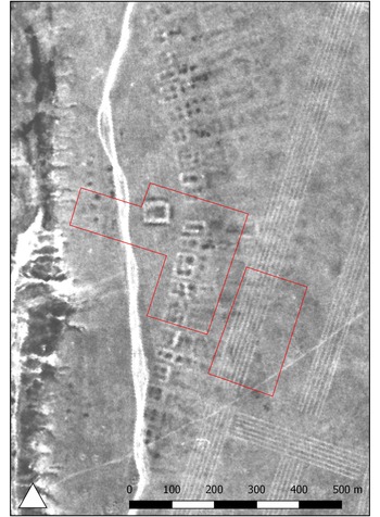
The site of Semiyarka is situated on a promontory overlooking the Irtysh River in the Beskaragay district of Abai Oblast, Kazakhstan, 180km south-east of the city of Pavlodar. Identified in the early 2000s, preliminary investigations (Mertz Reference Mertz and Grushin2006, Reference Mertz2017) suggested the site covered 40ha, with rectilinear earthworks that stretch for over 1km clearly visible in satellite imagery (Figure 1) and confirmed through on-site surveys (Figure 2). Surface finds from these surveys include pottery from Late Bronze Age cultures, specifically Cherkaskul (1600–1250 BC) and Alekseevka-Sargary (1500–1100 BC), and evidence of metallurgical activity: ores, slag, crucibles and finished metal artefacts.

Figure 1. Corona spy photograph of Semiyarka (KH4B Mission 1116, April 1972). Red boxes indicategeophysical prospection areas shown in Figure 4 (figure by authors).

Figure 2. Drone photograph of the archaeological site of Semiyarka, looking from the south-east to the north-west, taken in July 2018 (photograph by Peter J. Brown).
Emerging first in western Siberia, the Andronoid Cherkaskul culture represented a fusion of Andronovo and local traditions, with communities engaged in agropastoralism, hunting, gathering, and fishing (Korochkova Reference Korochkova2010). Alongside it, the Alekseevka-Sargary material culture spread across the eastern Eurasian Steppe, marking the development of more permanent dwellings and settlements up to 30ha (Agapov et al. Reference Agapov, Degtyareva, Kuzminykh, Stöllner and Samašev2013; Varfolomeev et al. Reference Varfolomeev, Loman and Evdokimov2017).
Material from Semiyarka predominantly relates to the Alekseevka–Sargary culture, with finds also attributable to the Cherkaskul culture. The site’s size, together with the presence of rectilinear earthworks and metallurgical evidence, highlight its potential importance for advancing our understanding of regional settlement patterns, social organisation and technology.
In 2018, a UK–Kazakh team initiated geophysical investigations at Semiyarka. Surface collection recovered abundant Late Bronze Age ceramics alongside metallurgical debris, including substantial evidence for tin-bronze production. These finds suggest that Semiyarka was likely a highly organised metallurgical centre capable of controlled production, challenging assumptions about the absence of structured metal economies among semi-nomadic steppe communities. Geophysical survey also revealed architectural traces within the earthworks, indicating a structured layout. These results underpin ongoing excavation and absolute dating, now integrated into the European Research Council/UK Research and Innovation-funded DREAM project at University College London.
Topography and results of geophysical prospection
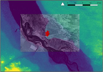
Located where the Irtysh Valley narrows, Semiyarka may have had control over movement along the river and the valley bottom (Figure 3). Several sites of similar date have been surveyed within the region, including two burial mounds to the north of the site and several small, ephemeral occupations along the river (e.g. Semiyarka 4–5, Altybai, Lesnoe, Nurbai, Chemaar). At Semiyarka, earthworks are clearly visible; rising approximately 1m above the ground surface, they consist of two rows of structures with internal divisions, suggesting a degree of architectural planning (Figures 1 & 2). A central structure, oriented almost exactly east–west, is set just behind the meeting point of the two rows of earthworks. The orientation and larger size suggest this structure may have held a ritual or communal function (Mertz Reference Mertz2017).

Figure 3. Digital Elevation Model (NASA Shuttle Radar Topography Mission) for the area around Semiyarka with overlaid Corona spy photograph showing the landscape in the early 1970s (KH4B Mission 1116, April 1972). Red dots indicate collection units in Figure 5 (figure by authors).
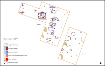
Geophysical surveys focused on the earthworks and an area associated with metallurgical activities (Figures 4 & 5). The results show that substantial walls, likely of mudbrick, were built along the inside edges of the earthworks, with internal divisions also visible. Given their scale and ubiquity, these were likely domestic structures. The central structure was approximately double the size of these units and may have had a central chamber or courtyard; possibly representing a centralised institution or a richer household. The scale of the earthworks is unusual, with their size and arrangement deviating from more conventional settlement patterns observed in the region.

Figure 4. Map of features identified through geophysical prospection by Archaeological Services, Durham University (figure by authors).

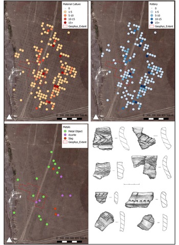
Figure 5. Material-culture distributions at Semiyarka. Top left: distribution of all material culture; top right: distribution of ceramics; bottom left: distribution of metals. Drawings show pottery from the Alekseevka-Sargary (upper four sherds) and Cherkaskul (lower four sherds) cultures. The boundaries of the site can be identified by the absence of material culture from multiple rows of collection units at the edges of the map images (figure by authors).
The second area was targeted by the geophysical survey due to surface evidence of metallurgical activities, including slags, crucibles and ores. However, this area revealed few features, suggesting that metallurgical production may have been dispersed or occurred in less architecturally formalised spaces.
Material culture distribution
Surface collection used 10m2 units spaced 50m apart. Finds were sparse due to compacted soils and often associated with modern disturbances from roadworks, water management and tree planting. The low-density surface scatter extends further east than the earthworks, suggesting more ephemeral, perhaps seasonal, occupation. Finished metal artefacts were primarily located in the western half of the site, while a concentration of metallurgical remains was identified to the south-east, suggesting a distinct production zone (Figure 5).
Metallurgy
The survey yielded metallurgical samples, including ores, crucibles, slags, production debris and finished artefacts, with 35 selected for analysis (Amirova Reference Amirova2019). Ores were mainly copper carbonates (malachite and azurite), with evidence for both copper and tin-bronze production (co-smelting and cementation, up to 12wt% tin). No evidence of arsenic, leaded or antimonial bronzes have been found. Technological analysis suggests the copper and tin ores likely originated from local deposits, probably the Altai Mountains in East Kazakhstan (cf. Chernikov Reference Chernikov1960).
Ceramics
Ceramic fragments representing at least 114 vessels were documented. Alekseevka-Sargary types make up 85 per cent of the assemblage, suggesting this was the primary cultural affiliation. The lesser presence of Andronoid pottery from the Cherkaskul culture (Figure 5, bottom right) evidences interactions with groups from western Siberia. The absence of Begazy-Dandybaev ceramics suggests that the settlement was established before this distinct tradition, likely during the sixteenth century BC.
Outlook
Based on a settlement size of 40ha and the presence of earthworks, Mertz (Reference Mertz2017) proposed Semiyarka as the largest ‘proto-city’ in the northern Kazakh steppes. Our work shows that the site was even larger, perhaps 140ha, and was likely a significant centre of metallurgical production. Few production centres have been identified in this region, almost exclusively in upland areas close to mines (Stöllner et al. Reference Stöllner and Yalçın2011). Semiyarka is the first large steppe centre with on-site tin-bronze production.
The site has few comparanda. Sites up to 30ha with substantial earthworks and domestic architecture are known, such as Čiča (Schneeweiss Reference Schneeweiss2007). The artefact scatter at Semiyarka is much larger than these, although the absence of identifiable structures in the results of geophysical prospection conducted away from the earthworks might suggest that artefact density does not directly correspond to built-up areas. The earthworks at Semiyarka are also unique in surrounding individual structures rather than the entire settlement. Excavations are needed to assess the architectural layout, provide further evidence for metallurgical processes and help contextualise Semiyarka’s role within regional networks.
Funding statement
This research was supported by the British Academy (Grant No. SG170607), the Ministry of Science and Higher Education of the Republic of Kazakhstan (Grant No. IRN AR26199457), and the European Research Council (ERC) under the UK Research and Innovation (UKRI) guarantee for the project Discovering the (R)Evolution of EurAsian Metallurgy: Social and Environmental Impact of the Bronze Age Steppes Metal-Driven Economy (DREAM) (Grant No. EP/Z00022X/1).
Author contribution: CRediT Taxonomy
Miljana Radivojevic: Conceptualization-Equal, Investigation-Equal, Methodology-Equal, Resources-Equal, Supervision-Equal, Visualization-Supporting, Data curation-Equal, Writing-Equal. Dan Lawrence: Conceptualization-Equal, Investigation-Equal, Methodology-Equal, Resources-Equal, Supervision-Equal, Visualization-Supporting, Data curation-Equal, Writing-Equal. Victor Merz: Conceptualization-Equal, Investigation-Supporting, Methodology-Equal, Resources-Equal, Supervision-Equal. Ilya Merz: Data curation-Equal, Formal analysis-Supporting, Investigation-Equal, Methodology-Supporting, Resources-Supporting, Supervision-Supporting, Writing - review & editing-Supporting. Elena Demidkova: Formal analysis-Supporting, Investigation-Supporting. Mark Woolston-Houshold: Investigation-Supporting, Methodology-Supporting, Visualization-Supporting. Richard Villis: Investigation-Supporting, Methodology-Supporting, Visualization-Supporting. Peter Brown: Investigation-Supporting, Methodology-Supporting, Visualization-Supporting.


 Open access