


Introduction
In April 2021, 59 bronze bracelets from two hoards dating to the Atlantic Middle Bronze Age 2 (AMBA 2, 1450–1300 BC) were extracted by a detectorist at Kerouarn, Prat, in northern Brittany. The archaeological context and the bracelets were partly destroyed, but the Regional Archaeology Service of Brittany prescribed a contextualising study of these hoards to save the remaining information, coordinated by the author. After a magnetic and electromagnetic survey (B. Fores, Inrap), two excavations were carried out in 2021 (Nordez Reference Nordez2022) and 2022 (Nordez unpublished data): 67 features were recorded over an area of 1500m2 (Figure 1). Many hoards were deposited in north-western France over this period, mainly made up of palstaves and/or ornaments (Boulud-Gazo et al. Reference Boulud-Gazo, Mélin, Nordez, Lachenal, Mordant, Nicolas and Véber2017; O'Connor et al. Reference O'Connor, Roberts, Wilkin, Lachenal, Mordant, Nicolas and Véber2017).

Figure 1. Location of the site and zenithal view, with preliminary phasing of the 67 features (drone photograph by M. Vallée, CAD by M. Nordez).
Three bracelet hoards
These excavations made it possible to demonstrate that the bracelets, which were complete before the detectorist's intervention, came from two distinct hoards (Figure 2A & 2B), at least one of which had originally been placed in a ceramic vessel (Figure 2A).

Figure 2. A) & B) Pits dug by the detectorist to extract hoards 1 and 2 (photographs by M. Mélin & I. Le Mée, CAD by M. Nordez); C) Hoard 3 still in situ, perhaps in a textile container (photographs by M. Nordez).
During the excavation, a third intact hoard was discovered, made up of 30 bracelets in a vessel with a lid, both ceramic. Field observations revealed that the vessel had been inside a now-lost organic bag, which had held the bracelets against the vessel when it was deposited and tipped over. The vessel was removed as a block and excavated in the Arc'Antique laboratory in Nantes, showing that the bracelets were organised in horizontal and vertical stacks (Figure 2C). To date, the site of Kerouarn has yielded the largest number of bracelets (at least 89) and the largest mass of ornaments (15kg) of the Atlantic Middle Bronze Age.
A semi-circular monumentalised space
Magnetic surveys (Figure 3) and excavations showed that the three hoards were deposited in a 26m-wide semi-circular area delimited by two curved ditches (Figure 1). Pottery analysis and a radiocarbon date on charcoal (CIRAM-3139: 3087 ± 27 BP, 1421–1272 cal BC at 95.4%; date modelled in OxCal v.4.4.4, using IntCal20 calibration curve (Bronk Ramsey 2021; Reimer et al. 2020)) indicates that the ditches and hoards were contemporary. Ditch segment 1 lies against a (now) rather low granitic outcrop in the west, but there is no indication that this area was closed to the north. The ditch may have been extended by now-lost structures (e.g. hedge or fence line), or it may have adjoined a natural barrier (e.g. trees or now-eroded hillside).

Figure 3. Mapping of magnetic anomalies (by B. Fores, Inrap) and main ditches excavated (CAD by M. Nordez).
The two ditch segments, which are preserved to a depth of 1.5m, are associated with an embankment (Figure 4A). The ends are rounded with steep sides, and create a 5m-wide opening. This access from the south must have appeared rather imposing and several elements point to its importance: two ceramic vessels were deposited side by side at the base of ditch segment 2 (Figure 4B), and fragments of a large block of worked granite were found in the upper fill, perhaps indicating the presence of a stele beside the entrance (Figure 4C). In its final phase, ditch section 1 cut through a large hole containing burnt wood and earth. Radiocarbon dates on two charcoal samples indicate that this feature dates to the Middle Neolithic 2 (CIRAM-5186: 5207±30 BP and CIRAM-5745: 5220±30 BP, 4054-3958 cal BC, at 90.8% confidence and 4061–3961 cal BC, at 83.4% confidence; date modelled in OxCal v.4.4.4, using IntCal20 calibration curve (Bronk Ramsey 2021; Reimer et al. 2020)) (Figure 4D).

Figure 4. A) Transverse section of the ditch showing the main fill sequence (CAD by M. Nordez); B) vessels deposited at the bottom of the ditch, near the entrance (photographs by A. Maguy & M. Perrin); C) large broken granite block (possible stele fragment?) (photograph by R. Castillo Latorre); D) end of ditch 1 intersecting an older feature, containing burnt wood and sediment (post?) (photograph by G. Daniel, CAD by M. Nordez).
The ditch had been repeatedly maintained, and re-dug several times (Figure 4A), but ceramics found in the lower and upper fills are all attributed to the AMBA 2, so it was in use for no more than 150 years.
A communal space? A sacred place?
Geophysical prospections brought to light other features in the area around the hoards, but all are more recent (Figure 3). The only features attributed to the Middle Bronze Age are the two ditch segments and the three ornament hoards. There are no contemporary built structures in this 225m2 semi-circular area and this absence cannot be explained by erosion. This lack of domestic or funerary remains, in combination with the monumentality of this complex, suggests other functions. This partially enclosed (and possibly hidden) place may have been used to bring people together, possibly for ritual, religious and/or socioeconomic purposes. The hoards may either be the cause of these gatherings or a visible consequence, possibly among others that left no trace.
Three exceptional sets of bracelets
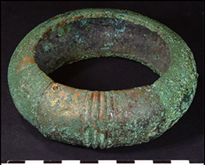
The 89 bracelets constituting the three hoards all have a massive plano-convex or concave-convex section and are decorated with a finely crafted geometric motif. The majority (81) have a closed shape with bulges hiding the ends (Figure 5A)—very rare characteristics that led us to define them as the ‘Prat’ type, although the typology of AMBA ornaments has recently been updated (Nordez Reference Nordez2019). Only one bracelet is penannular (Figure 5B). Seven others have a mortise-and-tenon locking system, sometimes hinged (Figures 5C & 6). The most complex example is particularly massive (600g, Figure 6).

Figure 5. Main types of bracelets (photographs by M. Nordez): A) Prat type, with variation in the number of terminal bulges; B) unique open bracelet from the hoards; C) cast residues trapped in the internal side of a locking system.

Figure 6. The most massive bracelet, with hinged locking system (photographs by M. Nordez; tomography by G. Bourbouze).
Technical markers (dendritic surfaces, casting flaws intersecting the decorations, repairs by secondary casting, etc.) indicate that all the bracelets were made using the lost wax casting technique, like most bracelets of this period (Nordez Reference Nordez2019: 219–22). The quantity and exceptional quality of the bracelets, the fact that they were buried in a vessel and the diverse stages of manufacture and wear (unfinished to very worn) raise the question of the function of these objects. Were they intended to be worn? Are they only ornaments or are they, rather, some form of pre-monetary currency?
Conclusion and further perspectives
Hoards are no longer considered merely in terms of the objects they comprise but must be understood with reference to their contexts—including the conditions of deposition—and analysed in relation to the site and landscape within which they were deposited. One of the primary results of the Kerouarn project is that it demonstrates the importance of geophysical studies coupled with excavations in understanding metalwork hoards in their archaeological contexts.
Several sites with multiple hoards are known in Brittany (e.g. Belle-Île-en-Mer, Saint-Igeaux, Gouesnac'h, Saint-Glen), but all date from the Late Bronze to the Early Iron Age. To date, Prat is the only AMBA site with multiple hoards in Brittany. There are cases in neighbouring regions, such as Ribécourt-Dreslincourt (Oise, France), where three hoards were each associated with a post that marked their position in the landscape (Guérin et al. Reference Guérin, Mélin and Nordez2022).
Treatment of the Kerouarn excavation data is still in progress and the results will be presented in detailed publications, which will be prepared in the coming months, concerning the archaeological context, hoarding practices, the ornaments, and the lost-wax casting technique.
Funding statement
This project was funded by the French Ministry of Culture, supported by the Regional Archaeological Service of Brittany.
Acknowledgements
The author would like to thank Muriel Mélin, Adrien Maguy and the whole excavation team for their commitment, as well as all the specialists for their contributions.


 Open access