


Introduction
Fortified sites dominate our view of the central places of power and governance in the early medieval period, particularly in northern and western Britain (Alcock Reference Alcock2003: 179; Seaman Reference Seaman, Christie and Herold2016: 37; Noble et al. Reference Noble, Gondek, Campbell, Evans, Hamilton and Taylor2019: 57). These sites can be understood within the context of a wider movement towards the (re)occupation of hilltops across much of Europe between the third/fourth and seventh centuries AD (Pavlovič & Heinrich-Tamáska Reference Pavlovič and Heinrich-Tamáska2022). Our understanding of this European ‘Late Antique hillfort phenomenon’ is constrained, however, by the limited number of large-scale excavations and a lack of reliable dating evidence. Leslie Alcock's 1953–58 excavations at Dinas Powys on the south coast of Wales, which recovered what was at the time and remains today, the largest assemblage of post-Roman (fifth to seventh century) material culture from Wales, provide an internationally important case study.
Alcock's Reference Alcock1963 publication of the excavations established Dinas Powys as a type site for post-Roman western Britain. Indeed, for 30 years until the publication of the investigations at Cadbury Congresbury hillfort (Rahtz et al. Reference Rahtz, Woodward, Burrow, Everton, Watts, Peach, Hirst, Fowler and Gardner1992), it was the only post-Roman site in Britain excavated and published to modern standards and thus defined understanding of early medieval ‘Celtic’ settlement in western Britain for a generation of students and academics. Dinas Powys provides a rare example for the emergence of post-Roman society in a lowland region of the western Roman Empire that was unaffected by ‘barbarian’ incursion in the fifth and sixth centuries AD (Wickham Reference Wickham2010). It was also one of the first hillforts to have a substantial proportion of its interior excavated, a strategy that remains rare in the investigation of such early medieval sites. Alcock's report was particularly influential due to his attempt to use Welsh and Irish legal and other texts to reconstruct the site's social and political context in the early medieval period. Dinas Powys, he argued, was ‘the court (llys) and hall (neuadd) of a chieftain’ of the emergent post-Roman kingdom of Glywysing (Alcock Reference Alcock1963: vii). Alcock's use of late medieval sources was problematic, however, and several aspects of his interpretation have been challenged (Campbell Reference Campbell1991; Seaman Reference Seaman2013).
Nevertheless, the scale of Alcock's excavations and the diversity of the finds recovered remain of international significance and Dinas Powys continues to feature prominently in historical and archaeological scholarship in and beyond Wales (e.g. Davies Reference Davies1982: 20, 23, 35; Wickham Reference Wickham2005: 815; Charles-Edwards Reference Charles-Edwards2013: 223; Carver Reference Carver2019: 189; Naismith Reference Naismith2021: 169). Our understanding of the substantial artefact assemblage has been enhanced by important re-analysis (Campbell Reference Campbell1991; Graham-Campbell Reference Graham-Campbell1991), but uncertainties persist regarding the chronology of the site. Alcock's interpretation of the results of the excavations was hindered by the complex and disturbed stratigraphy of the site, a lack of scientific dating and the excavation techniques of the time. These issues have been compounded by misreadings of Alcock's sequence and wider misconceptions about the form of early medieval fortifications (Alcock Reference Alcock1980). Significant problems with the proposed dating of Dinas Powys were highlighted as early as 1988 (Campbell in Edwards & Lane Reference Edwards and Lane1988: 59–61).
A detailed alternative phasing has been presented by Campbell (Reference Campbell1991, Reference Campbell and Pounds1993, Reference Campbell2007), subsequently supported by preliminary radiocarbon dating of material from the site archive (Seaman Reference Seaman2013: 5–6). Nevertheless, Alcock's original chronology still features in specialist and popular literature, and even in the National Monuments Record of Wales (RCAHMW 1991: 99–103; Snyder Reference Snyder1998: 190–2; Konstam Reference Konstam2008: 60; Wiles Reference Wiles2008; Carver Reference Carver2019: 189–91). The present article draws together more than 30 years of research that challenges and refines the site chronology of Dinas Powys, and integrates a series of more robust absolute dates from a new programme of radiocarbon dating presented here for the first time. We set out a new phasing for Dinas Powys, with substantial implications for the interpretation of this prominent Welsh early medieval site, and for our understanding of post-Roman western Britain and the (re)occupation of Late Antique hilltop sites more generally.
Power centres of the ‘Celtic West’
Dinas Powys (ST148723), Glamorgan, is a small inland promontory fort of approximately 0.35ha that is enclosed by four sets of banks and ditches on its southern side. It occupies the tip of a prominent whaleback ridge, the ground dropping off steeply all around. Today, the site is densely wooded, but a recent programme of terrestrial laser scanning provides a clear visualisation of the monumentality of the defences, which stand in contrast to the small area enclosed (Figures 1 & 2). Three of the four banks (1, 3 & 4) are at least 6m wide and 4m high, from bank top to ditch base, and cover an area of 0.25ha; the enclosed interior is only 0.1ha in extent. The layout of the earthworks suggests that bank 2 was constructed first, followed by banks 1 and 3, the latter succeeded by bank 4. Approximately 140m to the south lies a second set of earthworks referred to by Alcock as the ‘Southern Banks’ but officially known as the Ty'n-y-Coed earthworks. These earthworks consist of two sections of bank and ditch forming the north-west and north-east sides of a partial enclosure with dimensions of at least 60m north-east by 50m south-west.

Figure 1. Laser scan of the promontory fort earthworks at Dinas Powys (figure by Andy Seaman).

Figure 2. Dinas Powys and Ty'n-y-coed earthworks. 2011–14 trenches shaded. Adapted from RCAHMW image 118383 (© Crown copyright: RCAHMW) (figure by Andy Seaman).
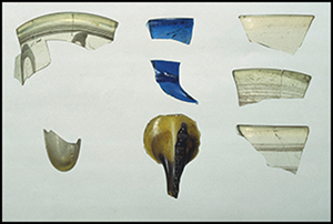
Dinas Powys was initially thought to date to the Iron Age, but Alcock's excavations quickly discovered sherds of imported post-Roman pottery that were directly comparable to those recently published from Tintagel, Cornwall (Radford Reference Radford and Harden1956). Alcock (Reference Alcock1956: 247) also recovered sherds of glass from Merovingian and Anglo-Saxon vessels. During the 1950s, post-Roman material was barely known from Wales, but the richness of the Dinas Powys assemblage indicated activity of significant social status. The exotic and high-status material included the pottery and glass, as well as a large quantity of animal bone, ferrous and non-ferrous metalwork, and evidence for the production of ornamental metalwork, including penannular brooches (Campbell Reference Campbell1991: 434–8; Figures 3 & 4). Evidence for features within the enclosure was slight, but those that were identified included several hearths, along with drainage gullies and postholes that were tentatively interpreted as evidence for two buildings (Figure 5). Approximately 30 contemporaneous hillforts and enclosed settlements are now known in Wales and south-west England (Seaman Reference Seaman, Christie and Herold2016, Reference Seaman, Pergola, Castiglia, Essa Kas Hanna and Segura2022), but Dinas Powys remains one of the most important in terms of the quality and quantity of its assemblage. In contrast to the finds at the promontory fort, the Ty'n-y-Coed earthworks produced little material, nonetheless Alcock considered the two proximate sites as at least partly connected.

Figure 3. Reconstruction of a penannular brooch, based on a fragment of a mould die found at Dinas Powys (© Amgueddfa Cymru National Museum Wales).

Figure 4. Selection of artefacts, clockwise from top right: Phocaean red slipware; fragment of lead mould die; copper-alloy mount; millefiori glass rod; crucible; Atlantic and Anglo-Saxon tradition glass (© Amgueddfa Cymru National Museum Wales) (figure by Mark Lodwick).
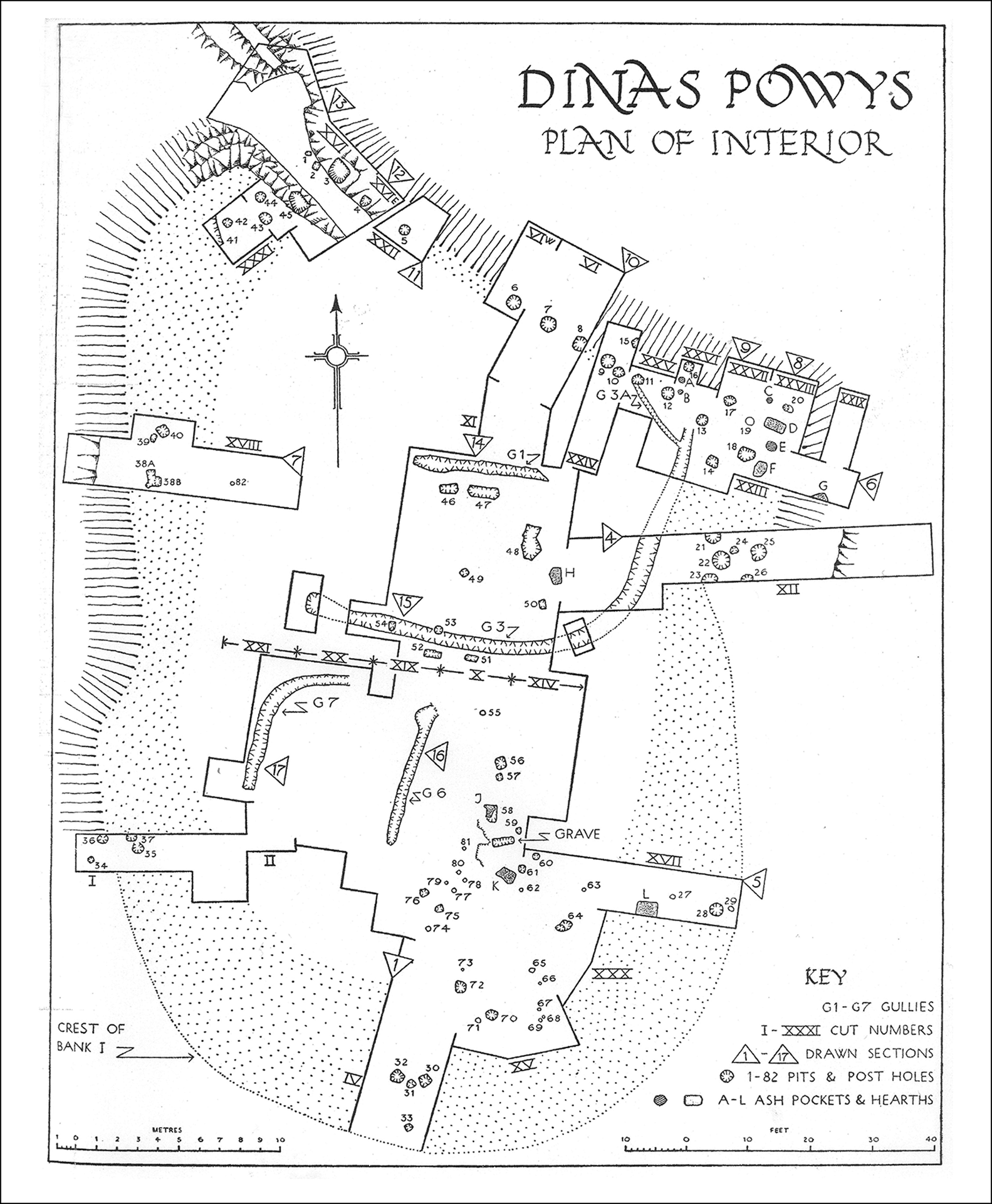
Figure 5. Plan of excavated features (reproduced with the permission of the University of Wales Press).
Dating Dinas Powys
Alcock's chronology
Alcock's chronology followed a six-phase scheme (Alcock Reference Alcock1963). Phases 1 and 2 were identified as a pre-Roman settlement, including an enclosed phase defined by Ty'n-y-Coed bank A. Phase 3 was represented by a small number of Romano-British artefacts brought to the site from other areas of occupation within the landscape. In phase 4, the early medieval occupation took shape within a single bank-and-ditch enclosure (bank 2). This was split into two sub-phases: a fifth-century occupation (phase 4a) associated with hearths, a post-built structure, a single infant burial and possibly an enclosing palisade; and, subsequently, a fifth- to seventh-century phase (phase 4b) associated with two buildings identified by drainage gullies, and the accumulation of rich midden material. Following phase 4 the site was abandoned until the late eleventh or twelfth century. The final two phases were dated to the Norman period: first, a native Welsh ringwork castle (eleventh to twelfth century) defined by bank 1 surmounted by a timber palisade (phase 5), subsequently replaced by a multivallate ringwork castle of the late eleventh to twelfth century (phase 6), built in response to the threat of Norman invasion. The later ringwork castle was defined by banks 3 and 4 and an incomplete outer bailey (bank 5); Alcock argued this was built while the site was under siege from Ty'n-y-Coed bank B, the latter interpreted as a Norman siegework.
Alcock (Reference Alcock1963: 61) interpreted phase 4 of the site as a “princely household”, importing wine and pottery from the Mediterranean and hosting craftworkers who made fine objects of bronze and gold (Alcock Reference Alcock1963). While Alcock thought this settlement was of high status, he did not consider it to be a hillfort, but rather a weakly enclosed settlement. He explored the possibility that the monumental banks 1, 3 and 4 belonged to phase 4, but ultimately ascribed them to the ringwork castle of phases 5–6 (Alcock Reference Alcock1963: 73–93). Based on this interpretation, in a short, but influential, article he used Dinas Powys to make the generalised statement that early medieval forts were less than two and a half acres (approximately 1ha) in extent and had “only puny defences” (Alcock Reference Alcock1962: 52).
Problems with Alcock's chronology
Alcock's dating of the multivallate works was based on weak evidence: he argued that five sherds from a single vessel of ‘Norman pottery’ found in the upper, and much disturbed, layers of bank 1 provided a terminus post quem for the bank's construction. His reasoning was influenced by contemporary research on siegeworks and his direct experience in the investigation of ringwork castles (Renn Reference Renn1959; King & Alcock Reference King and Alcock1969). The latter included excavations at Penmaen, where the defences and positioning in the landscape display superficial similarities to Dinas Powys (Alcock Reference Alcock1963: 74–81, Reference Alcock1966; J. Knight pers. comm.). Alcock was aware that multivallate ringworks and the form of the Ty'n-y-Coed bank B ‘siegework’ were unusual (Alcock Reference Alcock1963: 91–93) and, aware of a growing critique, he did revisit his interpretations in a later publication, but ultimately reasserted his original sequence (Alcock Reference Alcock1987: 20–66, 83–96). The Royal Commission on the Ancient and Historical Monuments of Wales (RCAHMW) also persisted in following Alcock's dating of Dinas Powys to the late eleventh or twelfth century, despite noting its exceptional topographical location and form (RCAHMW 1991: 98).
In the late 1980s, a detailed critical analysis of the dating of Alcock's phases 5 and 6, noted that there were no other native Welsh defensive works in Glamorgan of the immediate pre-Norman date, and that those built after the invasion were confined to upland lordships that remained under Welsh control (Campbell Reference Campbell1991, Reference Campbell and Pounds1993, Reference Campbell2007: 97–9; Spurgeon Reference Spurgeon1991). Campbell also noted the lack of secure stratification for the pottery sherds from the upper layers of bank 1 and, moreover, that this type of pottery post-dated the Norman invasion of south Wales (Vince Reference Vince1983: 712; Papazian Reference Papazian1990: 24). Several features of the ‘ringworks’ are unusual in a Norman context, including the multiple banks and ditches, the use of stone-revetments, the presence of a palisade and the steep narrow path to the entrance. The defences were noted to be much more characteristic of the local Iron Age/early medieval tradition of hillfort construction (RCAHMW 1976). The lack of parallels for the ‘siegework’ to the south was also highlighted (e.g. Renn Reference Renn1959: fig 3), as was the paucity of Norman-period finds at Dinas Powys, in contrast to other sites dating to the initial phase of Norman colonisation of Glamorgan (e.g. Alcock Reference Alcock1966; Charlton et al. Reference Charlton, Roberts and Vale1977; Papazian Reference Papazian1990: site 29). Campbell therefore concluded that the evidence for a Norman-period phase at Dinas Powys was extremely limited. In contrast, spatial distribution analysis has shown that, in the south-east area of the fort at least, early medieval pottery and glass formed coherent groups of fragments from individual vessels, and that in relation to bank 1, the stratigraphic position of imported material corresponds with the relative dating of these imports (Campbell Reference Campbell2007: 88–99; Figure 6). These observations preclude Alcock's hypothesis that early medieval material had been ‘scraped-up’ and redeposited to form the later Norman defences.

Figure 6. Schematic section of cut XVII (south-eastern side of the fort) with individual imported vessels, showing stratigraphic differentiation between sherds of Mediterranean (later fifth to early sixth century, open circles) and Continental (later sixth to seventh century, solid circles) imports (figure by Ewan Campbell).
New dating evidence
Campbell's (Reference Campbell1991) initial critique noted that radiocarbon dating could be used to test Alcock's dating of phases 5 and 6. But, while stratified charcoal samples were identified in Alcock's archive these were, at the time, too small for dating. Subsequently, with the assistance of Amgueddfa Cymru (National Museum Wales), it has been possible to identify eight charcoal samples suitable for dating with modern AMS techniques (Table 1). These are single entity, short-life samples from securely stratified contexts. Four of these samples are from the fills of postholes associated with the ‘palisade’ that Alcock deemed to be contemporaneous with, or slightly later than, bank 1. Two samples are from the midden deposits on the back of bank 1 and of the two other samples, one comes from a posthole and the other from a metalworking deposit associated with a fragment of a lead die for a penannular brooch mould, both deposits sealed by the construction of bank 1.
Table 1. Radiocarbon dates associated with bank 1, calibrated in OxCal 4.4 using the IntCal 20 curve (Bronk Ramsey Reference Bronk Ramsey2009; Reimer et al. Reference Reimer2020).

All the new calibrated radiocarbon dates, including the six from Alcock's ‘Norman-period’ phase 5, fall in the fifth to seventh centuries AD (Table 1). There are some cases of probable residuality and intrusion: for example, material from below bank 1 returns slightly later dates than the secondary fills of the postholes that cut it, but none of the dated features indicates Norman-period activity. Indeed, Bayesian modelling suggests that the dated activity began in (cal AD 510–600; 95% probability) and did not stretch beyond the seventh century (end date cal AD 590–680; 95% probability), phasing which correlates with the artefactual evidence (Campbell Reference Campbell1991: 97). While there are only a small number of dates available thus far, the modelling also suggests a relatively short span of activity: between 0 and 145 years (95% probability; Figure 7).

Figure 7. Single-phase model for radiocarbon dates associated with bank 1. Modelled in OxCal 4.4 using the IntCal 20 curve (Bronk Ramsey Reference Bronk Ramsey2009; Reimer et al. Reference Reimer2020) (figure by Andy Seaman).
Alcock's single ‘cutting’ through the Ty'n-y-Coed earthworks produced few features and very little material culture and his dating was, by his own admission, speculative, including both a possible Iron Age phase (bank A) and a Norman-period ‘siegework’ (bank B). Excavations by Seaman and Lane in 2011–14 found no evidence for a Norman phase at the Ty'n-y-coed earthworks (Seaman & Lane Reference Seaman and Lane2019). A sherd of South West Decorated Ware pottery, however, was recovered during the 2011–14 excavation from below bank B, while investigation of the associated ditch revealed an almost complete vessel, also South West Decorated Ware, within the lower fill of the associated ditch. South West Decorated Ware circulated in south Wales between the late-second century BC and the mid-first century AD. A sherd of mid second-century Samian ware was also recovered from the upper fill of the same ditch. The ditch of bank A included charred material dating to the sixth to eighth centuries AD, broadly contemporaneous with, if slightly later than, bank 1 in the interior of Dinas Powys. No conclusive dating material from bank A was recovered, but the finds from an agricultural soil sealed by the bank included two small sherds of South West Decorated Ware. The radiocarbon dates from the ditch associated with bank A provide a strong indication that the ditch was not cut before the mid-seventh century AD (Seaman & Lane Reference Seaman and Lane2019: 130).
A new chronology
The acquisition of new radiocarbon dates means that a revised chronology can be proposed for Dinas Powys.
Phase 1 relates to Neolithic/Early Bronze Age activity, perhaps consisting of an unenclosed settlement situated both on the promontory and in the Ty'n-y-Coed earthworks area. Understanding of the nature and chronology of the prehistoric material recovered by Alcock has improved significantly since the 1950s, and re-analysis of the Dinas Powys material suggests revision of the early part of Alcock's dating scheme is needed. While the quantity of prehistoric pottery and flint finds is not large (169 pieces of flint from the 1953–58 excavation and 11 pieces from 2011–14), the character and quantity is generally consistent with some form of in situ Neolithic and Early Bronze Age settlement (Butler Reference Butler2005). The presence of primary and secondary flakes, cores and flake debitage indicate a series of individual knapping events. Although Neolithic or Early Bronze Age occupation features have not been identified, it is possible that the intensive later occupation has truncated or masked features from these earlier periods.
Phase 2 includes Middle to Late Bronze Age/Early Iron Age activity on the promontory, potentially associated with postholes identified by Alcock and possibly enclosed by bank 2. Sherds of prehistoric pottery from the promontory (see Figure 8), that Alcock assigned to his phase 1 (Iron Age A), can now be broadly assigned to the late Middle to Late Bronze Age (Jody Deacon, pers. comm.). Sherds from the make-up of banks 1 and 3, have a slightly later character, being much thinner-walled and displaying the finger-tip decoration characteristic of the Early Iron Age. Much of this material was recovered from early medieval contexts (see below), so it is difficult to determine the nature of activity. Nevertheless, a small amount of animal bone was recovered from deposits pre-dating rampart construction, and it is possible that postholes in the south-eastern part of the promontory, and below bank 3, are associated with this phase. Both Alcock (Reference Alcock1963: 27) and Campbell (Reference Campbell1991: 55; Reference Campbell2007) discussed the possibility that bank 2, which is of a very different character to banks 1, 3 and 4, was prehistoric in date, but ultimately they favoured construction in the fifth or sixth century AD. The dating evidence for bank 2 should not be overstated however, and while it is true that the distribution of prehistoric sherds extended either side of the bank, suggesting that occupation was not constrained by it, only two small sherds were recovered from beneath it. Indeed, when discussing a single sherd of early medieval imported pottery which was also found below the bank, Alcock (Reference Alcock1963: 27) noted that the area was much disturbed by animal burrows. Overall, the date of bank 2 is at present unresolved, and while Alcock argued that the focus of prehistoric settlement probably lay outside of the excavated area (Alcock Reference Alcock1963: 18–19), it remains a possibility that bank 2 was associated with occupation on the northern end of the promontory between the Middle Bronze Age and Early Iron Age.

Figure 8. Distribution of prehistoric pottery, excluding sherds from redeposited contexts (figure by Ewan Campbell).
Phase 3 consists of a Late Iron Age/early Roman settlement ‘enclosure’ (Ty'n-y-Coed bank B), which was probably associated with the formation of an agricultural soil sealed by Ty'n-y-Coed bank A. This appears to have been abandoned by the early Roman period, after which there is little evidence for activity here until the early medieval period.
Phase 4a sees intensive development from the fifth century AD onwards, beginning with high-status settlement activity on the promontory within the area enclosed by bank 2. This settlement was associated with metalworking evidence and Mediterranean imported pottery (Late Roman Amphora LR1, 2 & 4. Phocaean Red Slipware, African Red Slipware).
Phase 4b features a developed promontory fort of sixth to seventh century AD date. High-status occupation continued, but now associated with pottery (E ware, DSPA ware) and glass vessels derived from a later phase of trade focused on southern France, rather than the Mediterranean. Bank 1 was constructed and banks 3 and 4 are most likely of this phase too. Construction of Ty'n-y-Coed bank A, potentially an unfinished enclosure associated with unrealised re-occupation of the Late Iron Age bank B enclosure, may also belong to this or the following phase.
Phase 5 relates to the abandonment of the hill in the later seventh or eighth century.
Phase 6 is represented by small quantities of late- and post-medieval pottery, most likely derived from casual visits to the site and agricultural activity.
Discussion
Our proposed chronology for Dinas Powys departs significantly from the chronology put forward by Alcock and traditionally favoured in the literature published since. With regard to the early evidence, we suggest that the prehistoric activity was more persistent and prolonged than has been hitherto appreciated. Phase 1 activity is comparable with other hilltop flint scatters in the region, which appear to relate to temporary occupations exploiting areas of high ground (Locock Reference Locock2003). Post-Roman activity on the promontory may not have commenced until c. AD 500, with the major part of Alcock's proposed Norman-period ringwork castle, bank 1, now confirmed to be of early medieval date, as Campbell suspected, and most likely constructed in the late sixth or seventh century AD. Moreover, the early medieval midden deposits identified on the back of bank 1 can be confirmed as in situ material (see Campbell Reference Campbell2007: 88–99, fig. 69 for detailed spatial distributions of artefacts and reconstruction of activity areas). The new evidence strongly suggests that the defences of the early medieval fort were far from ‘puny’ and were greatly out of proportion to the area enclosed—an example of conspicuous display as well as heightened defence? (Seaman Reference Seaman2013: 10–11). The monumentality of the redated defences now better aligns with the richness and exceptional character of the early medieval artefact assemblage.
A possible socio-political context for this fortified power centre comes from the identification of charter evidence for a small, short-lived kingdom in the Cardiff area in the seventh or eighth centuries (Davies Reference Davies1978, 94; Reference Davies1982, fig. 38; Campbell Reference Campbell1991: 225). An important early ecclesiastical centre at Llandough lies approximately 2km to the east of Dinas Powys and the two sites may have formed part of a polyfocal central zone for the territory (Seaman Reference Seaman2013: 12–15). Alcock argued for a relationship between the apparently small size of forts such as Dinas Powys and the nature of warfare and social structure in post-Roman western Britain (Alcock Reference Alcock1971: 347). These ideas have been influential (e.g. Wickham Reference Wickham2005: 326–30), but must now be re-evaluated. Dinas Powys may be exceptional, but its wealth and monumentality contrast with interpretations of society in post-Roman western Britain as small-scale and economically under-developed.
Forts with close similarities to Dinas Powys in south Wales include Llanvithyn (ST054718), Parkmill (SS548892) and North Hill Tor (SS453938). The RCAHMW has dated North Hill Tor to the Norman period based on its similarities with Dinas Powys, and while it was noted that Llanvithyn and Parkmill are comparable to Dinas Powys in terms of size and morphology, their similarity was dismissed on the basis of Alcock's phasing of Dinas Powys (RCAHMW 1976: 14, 46, 117–19). The three forts are located close to significant evidence for early medieval activity, including early church foundations and cemeteries, and new dating evidence for Dinas Powys, presented here, indicates that further investigation of these three forts could substantially advance our understanding of early medieval south Wales (Campbell Reference Campbell1991: 228; Seaman & Sucharyna Thomas Reference Seaman and Thomas2020: 13–14).
The radiocarbon dates from Dinas Powys also suggest that early medieval activity was short-lived, as the promontory fort appears to have been abandoned by the later seventh century. Analysis of dates from all broadly comparable sites in Wales and south-west England indicates that there was a widespread move away from hillforts in the late-sixth/early-seventh century, pointing to a period of significant socio-political and economic change (Comeau et al. Reference Comeau, Seaman and Bloxam2023: 9–10). Consolidation of political units, the growth of the Christian Church and the effects of the Justinianic Plague may have had a significant impact on the decline of hillforts at this time (Campbell Reference Campbell2007: 132; Comeau et al. Reference Comeau, Seaman and Bloxam2023). The archaeological evidence from southern Britain contrasts with that from the north, where later first-millennium AD use of defended sites is increasingly attested (Noble Reference Noble, Christie and Herold2016: 30–1). Nevertheless, recent dating on sites in Scotland has shown that certain sites, similar to Dinas Powys, were also of relatively short duration, constructed and destroyed within a few generations at most (Noble et al. Reference Noble, Evans, Goldberg and Hamilton2022). The use of fortified sites and their abandonment appears to have been deeply implicated in the rise (and fall) of individual elite lineages in the early medieval north and west of Britain.
While the new dating from Dinas Powys is important, there is much yet to learn about this and other early medieval power centres in western Britain. Aspects of our re-interpretation of Dinas Powys remain tentative and new programmes of fieldwork and dating would greatly benefit our knowledge of such a key site. Further dating evidence for all the ramparts, along with reassessment of the existing material assemblages, which were only partially published by Alcock (see Campbell Reference Campbell1991: app 8), would be welcome. For example, although the Dinas Powys animal bone assemblage is the largest from western Britain, biases introduced through Alcock's sampling strategy and misunderstandings of the stratigraphy have inhibited re-analysis. The full research potential of Dinas Powys should be seen in the light of recent research-driven excavations of elite sites in other parts of Britain and Ireland, which have brought about step changes in knowledge and understanding (e.g. Noble et al. Reference Noble, Gondek, Campbell, Evans, Hamilton and Taylor2019; Scull & Thomas Reference Scull and Thomas2020; O'Brien & Hogan Reference O'Brien and Hogan2021). Comparable projects have not been undertaken in Wales and the hilltop location of elite sites of this period means that few are likely to be encountered through development-led investigations. Given its known research potential and the problems outlined above, a pressing case can be made for further excavation and further analysis of the archive material at Dinas Powys. For now, however, the reassessment presented here provides the best understood and dated sequence for any early medieval fort in Wales.
Overall, this article has highlighted how a single pioneering excavation can influence archaeological thinking for generations, and how difficult it can be to shift established narratives even in the face of new evidence. The short-lived burst of activity at hillforts during the fifth to seventh centuries AD was a Europe-wide phenomenon, extending to northern Britain and Ireland—areas which, unlike Dinas Powys, lay outside the former Roman Empire. The revised dating for Dinas Powys presented here provides the basis for a new narrative of the evolution of post-Roman society in western Britain and helps to tie it into similar developments attested elsewhere in western Europe.
Acknowledgements
The laser scan of Dinas Powys was undertaken by Cotswold Archaeology. We would also like to thank Jeremy Knight, Anna Bloxam, Mark Lodwick and Amgueddfa Cymru National Museum Wales.
Funding statement
Dates for bank 1 were partly funded by the Leverhulme Trust Comparative Kingship project (RL-2016-069).


 Open access