


Introduction
The site of Pire Mazar Balandar (or PMB001) is located near the village of Balandar in the Khorasan region of north-eastern Iran (33°09′37.64′′N, 59°29′52′′E; Figure 1). It consists of an outcrop of volcanic rock on a mountain peak (1532m asl) on the north-eastern side of the Binaloud range, above the city of Mashhad (Figure 2).

Figure 1. Map of Iran showing the location of Mashhad, Balandar and other rock art and archaeological sites (base map: Google Earth; edited by D. Sigari and M. Toghrae).
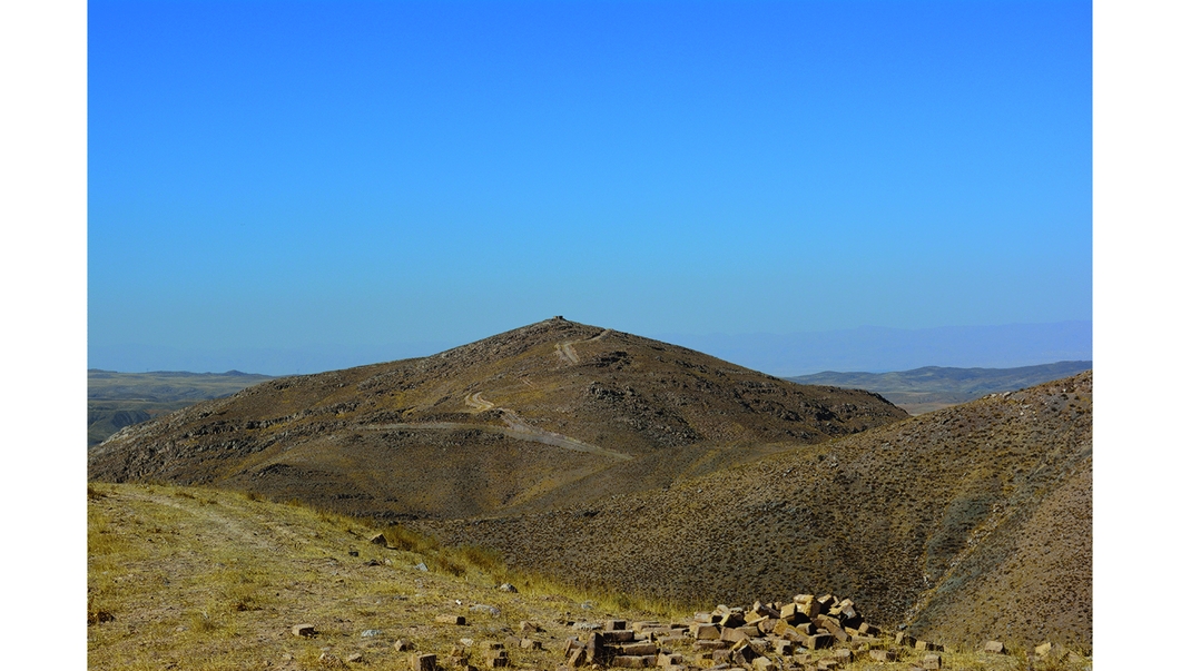
Figure 2. Panoramic view of the mountainous location of PMB001 (photograph: D. Sigari).
The outcrop at PMB001 is 1.2m wide and 0.75m long, and faces south-east. It is decorated with 16 simple symbols positioned with almost no superimposition: three axes, a spiral, a double circle, two pairs of parallel U-shaped lines, a single U-shaped line, a group of curved lines and a line shaped like a question mark (Figure 3).
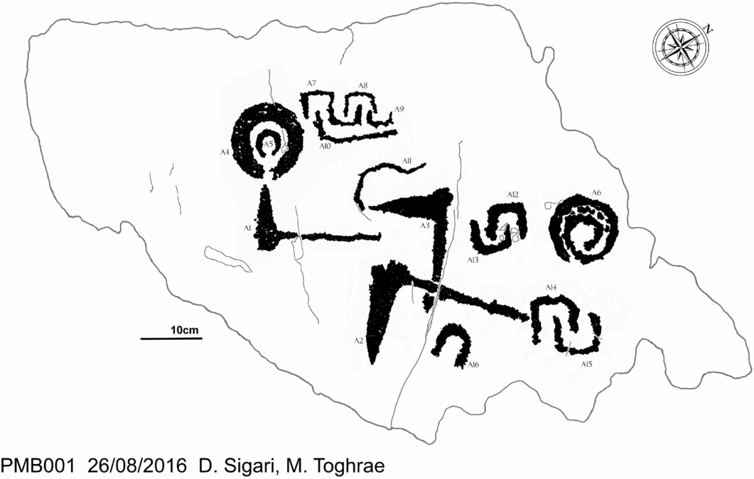
Figure 3. Tracing of PMB001 (tracing: D. Sigari and M. Toghrae).
The site was well known to local inhabitants, but was only documented archaeologically following its discovery in 2015 by Mahmoud Toghrae. PMB001 is considered a sacred stone by local worshippers, who believe that the U-shaped engravings are hoof prints of the horse of the prophet Imam Reza, who is buried in the Mashhad shrine. Pilgrims, who leave votive offerings such as miniature objects, or candles whose melted wax covers part of the rock surface, had begun building a small temple until stopped by the archaeologists’ intervention (Figure 4).

Figure 4. Photograph of PMB001. On its top are candles, stones and prayer beads offered by the worshippers to the prophet Imam Reza (photograph: D. Sigari).
Fieldwork undertaken in August 2016 aimed to document and record the rock art at PMB001 through a contact tracing, adopting a procedure developed by the Coop. Arch. ‘Le Orme dell'Uomo’ (Arcà et al. Reference Arcà, Casini, De Marinis and Fossati2008). A brief survey undertaken in the area around Balandar village, after the documentation of PMB001, led to the discovery of another rock art group, labelled BRA (Balandar rock art), located in a small creek, close to the road to Deh Gehibi. Here, petroglyphs are engraved on vertical schist panels, randomly distributed along the northern bank of a small seasonal creek. The subjects represented are zoomorphs and anthropomorphs, similar to those found all over the Iranian plateau (Naserifard Reference Naserifard2007; Sigari Reference Sigari2016). Patination suggests that they may be of some antiquity. Work to catalogue these petroglyphs is ongoing and the results will be discussed in greater detail in a further publication. In the absence of any other archaeological evidence from the vicinity of PMB001 and BRA, the dating of the petroglyphs must rely on comparisons with the wider context of the Khorasan region and its archaeological landscape.
The location of PMB001 permits sweeping views across the Mashhad Plain, including Tappeh Nadery (Habibi et al. Reference Habibi, Baikloo Islam and Eshqi2011), which is visible at a distance of 11km. This site is an artificial hill (Figure 5) preserving a long-term archaeological sequence, from the Chalcolithic to the Parthian period, testifying to continuous occupation of the region (Habibi et al. Reference Habibi, Baikloo Islam and Eshqi2011). If subsequent dating of the axes represented at PMB001 (Figure 6) points to the Bronze Age, as with those recently published by Begemann et al. (Reference Begemann, Haerinck, Overlaet, Schmitt-Strecker and Tallon2008: 62–63), this may indicate some type of link between the two sites and wider use of the landscape. The circular symbols, A4 and A5, are comparable to those found at Jorbat, which have been attributed to the Bronze Age or later (Vahdati Reference Vahdati2012). Without any chronologically diagnostic symbols or any superimposition, however, the dating of the rock art currently remains unknown.
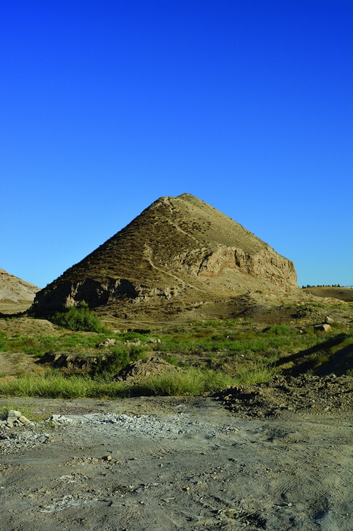
Figure 5. Photograph of the site of Tappeh Nadery (photograph: D. Sigari).
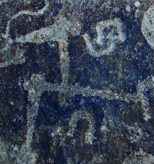
Figure 6. Axe figure A2 overlapping A4. It is the only superimposition of symbols on PMB001 (photograph: D. Sigari).
Both PMB001 and BRA present new questions in relation to the wider catalogue of rock art from the Khorasan region where other prehistoric rock art sites are known, including Shotor Sang, Kalateh Abdol, Bishiklik and the Toos Plain (Vahdati Reference Vahdati2012; Saffaran & Mozhdekanloo Reference Saffaran and Mozhdekanloo2014; Rezaei et al. Reference Rezaei, Soleymani and Ahmadi2016; Sigari Reference Sigari2016). These sites demonstrate how the recurrence of some motifs indicates the long-term use of the same subjects and symbols, making it difficult to advance any chronological framework (Vahdati Reference Vahdati2012). The case of PMB001, however, is a reminder that, regardless of the date at which they were first created, such sites can be used and adapted in later periods, and right through to the present.
Our research is ongoing. The next steps of the investigation will focus on the evidence for the location of rock art in different parts of the Mashhad landscape. At Balandar, for example, rock art has been found at the top of a mountain and along the course of a river, suggesting the possibility that distinct locations may correspond to different meanings. One of these, PMB001, perhaps with perceived greater sacred value, was later adapted in the light of new beliefs. Such repurposing of rock art for new beliefs and rituals will form another part of our ongoing research.
Acknowledgements
The authors would like to thank Mahmoud and Ali Sigari who helped to translate the Italian and English into Farsi.


