


Introduction
Surveys of archaeological sites conducted in the Nuussuaq region of north-west Greenland during the Vaigat Iceberg-Microbial Oil Degradation and Archaeological Heritage Investigation (VIMOA) research cruise documented five sites affected by exceptional and on-going deterioration of Arctic coastal archaeology. This process is exacerbated by detrimental weather conditions and temperature increases resulting from climate change. In addition to the five sites surveyed, the region hosts numerous other important archaeological sites, including the type-site for the Saqqaq cultural complex, the oldest documented human occupation in west Greenland dating to c. 4450–2850 cal BP.
The VIMOA project exemplifies the ways in which archaeologists and natural scientists can work together in a truly multidisciplinary fashion to achieve individual and common goals through holistic research strategies and shared resources. The project had three foci: to investigate microbial degradation of hydrocarbons in Greenlandic coastal seawater; to study the effects of icebergs on the distributions of hydrocarbons, nutrients, microbes and phytoplankton; and to assess the current state of archaeological sites in the Nuussuaq area. The archaeological aspect of the expedition contributes to the regional archaeological record by surveying five coastal sites to document their state of preservation.
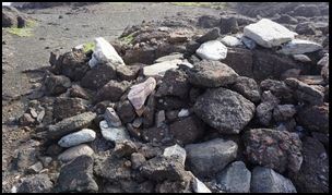
The archaeological survey focused primarily on the north-west of the Nuussuaq peninsula, covering the area surrounding the Kuugsuaq River delta and extending around 50km to the north-westernmost tip of the peninsula and the location of ‘The Bear Trap’ site (Figure 1). Site degradation over a 20-year period was documented by comparing photographs taken during survey in 2000 (Jensen Reference Jensen2001) with photographs taken during the 2019 survey from the same datum and direction (Figure 2). These clearly show the cumulative effects of 20 years of coastal erosion on the site, and its impact on the integrity of Arctic coastal archaeology in general.

Figure 1. Location map showing the Nuussuaq Peninsula and Qeqertarsuaq Island, West Greenland. Survey areas mentioned in the text are marked out as hashed polygons; the blue circle marks the location of the town of Ilulissat (figure by D.F. Carlson).

Figure 2. Comparison of the preservation of semi-subterranean peat houses on the terrace at Nussaq: left) photograph taken in 2000 (photograph by J.F. Jensen); right the same shoreline in 2019 (photograph by M.J. Walsh).
Methodology
Extensive aerial (drone) mapping and drone- and ground-based photography of the archaeological sites and features was undertaken during the survey. Agisoft Photoscan Professional version 1.4.5 ‘structure from motion’ photogrammetry software was used to process images acquired by a DJI Phantom 3 Standard quadcopter drone, fitted with a 12 megapixel digital camera. This was augmented by high-resolution ground-level photography using: a 50.6 megapixel Canon 5DSR Mk 3 full-frame DSLR fitted with a 24mm lens; a Sony a6000 APS-C mirrorless camera fitted with a 17mm lens; and a 24.3 megapixel SONY α5100 APS-C mirrorless camera fitted with a 24mm lens. The images were processed in Photoscan to produce high-resolution 3D point clouds, digital elevation models and orthomosaics that were geo-rectified using ground control points surveyed using real-time kinematic GPS (Figure 3).

Figure 3. Panoramic and aerial view of the Atanikerluk site (panoramic photograph by M.J. Walsh, aerial photograph by D.F. Carlson).
These digital products provide quantitative representations of overall site characteristics, as well as individual features such as peat houses, caches, cairns and graves. Three-dimensional models preserve these remote and rapidly deteriorating cultural heritage sites in a digital format, facilitating virtual exploration in the future. The imagery is used for documenting the current state of the archaeological sites in the survey areas, but will also be valuable for investigating terrestrial floral ecology and the abundance, and distribution, of nearshore macroalgae, further contributing to a holistic understanding of the ecology of these sites, and the region more generally.
Sites
During the Thule and early historic periods (c. AD 1300–1800), the sites of Nussaq, Atanikerluk and Niaqornaq were all moderately sized settlements, by regional standards. Each site has remnants of semi-subterranean houses built from peat and stone, and boasts numerous stone meat stores, several tent-rings and both prehistoric and historic graves (Figure 4). Nussaq is also the site of a large Christian cemetery. The sites all have extensive coastal middens; these are actively being lost to coastal erosion. Structures on each site are also imminently threatened by erosion. The integrity of the graves is being compromised at all of the sites, and all are in various states of deterioration, some with human remains completely exposed.

Figure 4. Saqqaq features at the Niaqornaarsuk site, with a Palaeo-Eskimo tent-ring in the foreground: left) photographed in 2000 (photograph by J.F. Jensen); right photographed during the 2019 VIMOA project survey (photograph by M.J. Walsh).
Niaqornaarsuk is located on a long headland connected to the mainland north of the Kuussuaq River delta by a tombolo forming broad sandy bays to the north and south. Jensen (Reference Jensen2009: 191) observed that the rocky formation on which this Saqqaq site is located might have been cut off from the mainland during prehistory. Earlier appraisals of the site identified a Palaeo-Eskimo presence—probably Saqqaq—and circular tent-rings and artefacts at both ends of the promontory suggest subsequent occupations (e.g. Jensen Reference Jensen2001). Photographs taken during Jen Fog Jensen's (Reference Jensen2001) survey were successfully replicated for comparison (Figure 5).

Figure 5. Top) view of Niaqornaq from the north-east; bottom left) northern cove at Niaqornaq showing a large peat house and midden directly on the shoreline erosion scar; bottom right) detail of well-sealed cairn grave with characteristic white stone capstones in place (photographs by M.J. Walsh).
‘The Bear Trap’ (Bjørnefælden in Danish), also known as ‘The Great Trap’ (Putdlagssuaq in Kalaallisut), is a unique structure in north-west Greenland (Figure 6). The building is a square, dry-stone built structure with a narrow entrance and an interior space of just 1.15 by 2.28m. It survives to a height of approximately 1.40m, but its original height and roof morphology remain conjectural. All four walls are over 1m wide. First documented in 1736 (Meldegaard Reference Meldegaard1995: 214), it was later recorded by Steenstrup (Reference Steenstrup1893), who described the structure and recorded its dimensions. Besides its eponymous purpose, The Bear Trap has been hypothesised as having been constructed as a storehouse by the Greenland Norse to store valuable commodities such as polar bear hides and narwhal and walrus tusks (Meldegaard Reference Meldegaard1995), particularly during large-scale hunting forays into the region (McGovern Reference McGovern, Green and Perlman1985). While the structure's original purpose is likely to elude positive identification, during our 2019 survey it was observed that The Bear Trap is located at the westernmost periphery of an early cemetery, probably associated with a settlement nearby to the south. Thus, we support the hypothesis proposed by Rosenkrantz (Reference Rosenkrantz1967), that the structure may actually have been a burial chamber, perhaps for a high-status Norse individual. Whatever the nature of the structure, it is a valuable part of the archaeological heritage of Greenland. A major contribution of the VIMOA project is the creation of a digital record to preserve the data of sites such as these. In this case, a detailed 3D model of The Bear Trap and its surroundings was created from the recorded data (Figure 6).

Figure 6. Left) view of ‘The Bear Trap’ from the south (photograph by M.J. Walsh); right) oblique view of a geo-rectified dense point cloud image of ‘The Bear Trap’ and immediate surrounding area looking north (image created by D.F. Carlson using drone imagery processed in Agisoft Photoscan).
Future directions
It has been well established that current environmental conditions, driven by climate change, are critically endangering archaeological heritage across the Arctic (Blankholm Reference Blankholm2009). One outcome of the VIMOA project has been to provide a digital platform for the preservation of data that will be both technically and analytically valuable to archaeologists, but also accessible and of interest to the wider public. We hope that the modelling aspect of the project will help to generate interest in the preservation of archaeological heritage in Greenland, and throughout the Arctic, while also raising awareness of the pressing need to preserve that archaeological heritage before it is lost.
Acknowledgements
The VIMOA project was funded by the Danish Centre for Marine Research (project number 2019-04), supported by the Arctic Research Centre at Aarhus University and it contributes to the Arctic Science Partnership. We thank the captain and crew of the M.S. Tulu, Egon Randa Frandsen at ARC, Jens Fog Jensen, Martin Appelt and Bjarne Grønnow at The National Museum of Denmark, and The Greenland National Museum and Archives.


