


The design methods used for churches constructed during the Early Byzantine period (between the 4th c. and the first half of the 7th c. CE) are well researched. They involved using sets of proportions based on descriptive architecture and accompanied by drawn plans and field sketches.Footnote 1 Much less is known about the methods used to design secular buildings. Excavations and surveys at Philoxenite (modern Ḥawwārīya, near Alexandria, Egypt) help expand our knowledge in this area. Research at the site has indicated that replicated plans were used on a mass scale in buildings erected no earlier than the mid-6th c. CE.Footnote 2 Discussion of their function has been limited so far and has not taken into account written sources. The findings will here be presented in detail and analyzed for the first time in the context of the building traditions of the Roman and Early Byzantine periods. Both analogies from cities and rarer examples from Christian pilgrimage sites will be taken into account. This will make it possible to determine the degree of uniqueness of the Philoxenite architecture and the influence of the pilgrimage movement on the development of architecture in towns of the Early Byzantine period.
Philoxenite was the largest settlement catering to the needs of pilgrims heading to the shrine of Saint Menas in Abū Mīnā. The large-scale use of modular design at the site aided in urban planning, and today it helps us determine the way the entire district was constructed in order to serve the needs of pilgrims. Philoxenite thus yields new insight into the influence of Christianity on Late Antique urban planning and the way that new cities were formed.Footnote 3 This paper describes the method used to design the structures in this location and places it in the wider context of ancient traditions. Shops, warehouses, and cisterns from Roman and Early Byzantine cities are used as comparative material. Contrasting the structures at Philoxenite with findings from other Christian pilgrimage sites helps reveal its unique nature.
Early Byzantine Philoxenite was an entirely new Christian settlement on the southern shores of Lake Mareotis.Footnote 4 The settlement provided accommodation to pilgrims heading from Alexandria, located 21 km away, to the great shrine of St. Menas, 17 km to the south (Fig. 1). Thanks to the Encomium of Saint Menas, it is known that construction at the site began during the reign of Emperor Justinian.Footnote 5 This is confirmed by the discovery of imported fine ware pottery in the foundation layers, placing the site's golden age at no earlier than the mid-6th c. CE.Footnote 6
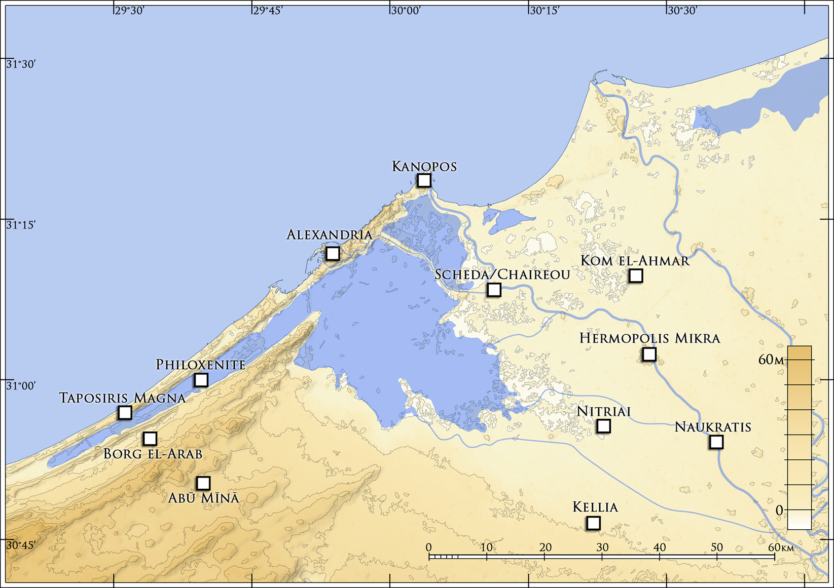
Fig. 1. Map of the environs of Alexandria showing the position of Philoxenite. (Courtesy of the Polish Center of Mediterranean Archaeology; drawing by J. Kaniszewski.)
The construction project covered an area of approximately 11 ha and involved the erection of churches, a monumental street (ST2) with adjoining buildings, and waterfronts with boardwalks and piers. This set of structures was complemented by several public latrines, a mill, and two bath complexes.Footnote 7 The buildings in this town were not built on an orthogonal plan; the streets run in straight lines and their arrangement is directly linked to the layout of monumental buildings (Fig. 2). Traces of extensive farmlands with an irrigation system were also identified on the outskirts of the town.Footnote 8 This agricultural base is a testament to the settlement's partial economic independence from the pilgrimage traffic. This independence is also confirmed by Philoxenite's continuous occupation in the second half of the 7th and the first half of the 8th c. CE.Footnote 9 During that period, the Abū Mīnā shrine had lost its importance as a pilgrimage center when compared to the Early Byzantine period.Footnote 10
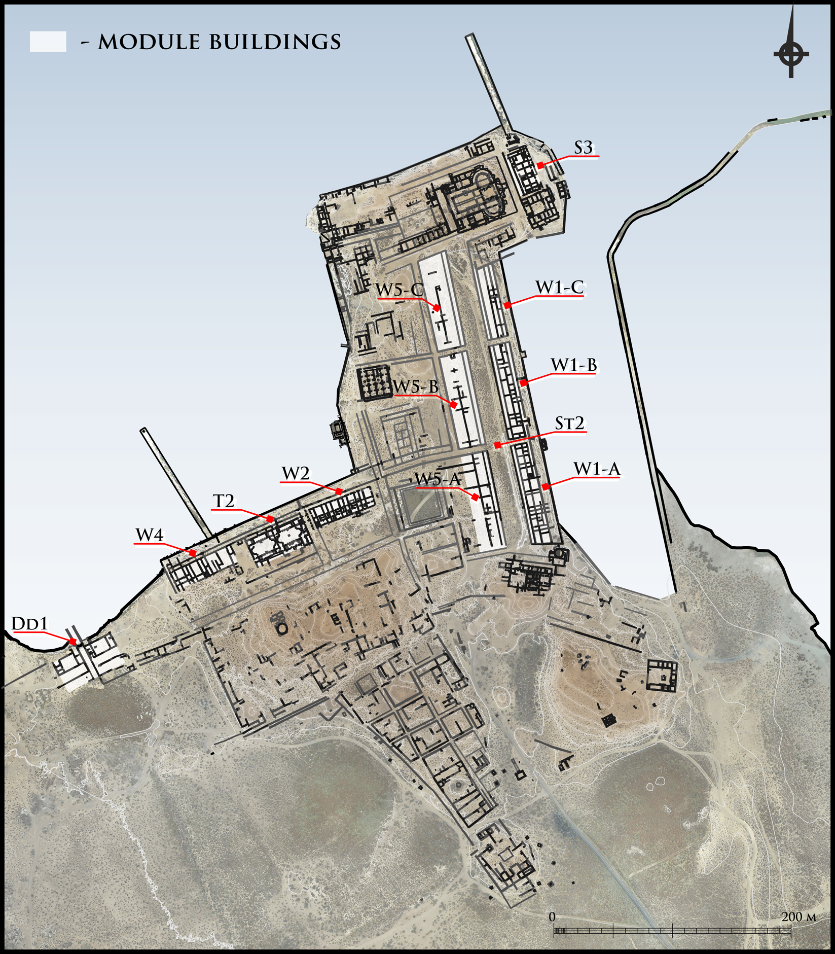
Fig. 2. Plan of Philoxenite with locations of the buildings mentioned in the text. (Courtesy of the Polish Center of Mediterranean Archaeology; drawing by A. B. Kutiak and M. Gwiazda.)
Although excavations on the site first began in the late 1970s, our understanding of the form and principles behind local urban development is still limited.Footnote 11 A new chapter in research was opened between 2018 and 2021 by archaeologists from the University of Warsaw, when the previous practice of uncovering entire buildings was abandoned in favor of extensive surveys with test pits.Footnote 12 The range of methods used during fieldwork was also expanded. These included non-invasive magnetic surveys combined with the creation of digital surface models using RTK (Real-Time Kinematic).Footnote 13 Such methods were able to capture the extent of the dense development of the town, and numerous previously unknown buildings were located. The work was also accompanied by an architectural survey, which involved sketching the wall tops visible on the surface of excavations using total stations. An orthophoto plan of the entire site was created using a UAV (Unmanned Aerial Vehicle), allowing all visible structures to be mapped, including those excavated by other archaeological teams. Orthophotos taken with a camera suspended from a 5-m aerial photography pole were used to document the buildings and their separate parts in more detail. In individual cases, building plans created using this varied documentation were verified and refined through small-scale archaeological test trenches. These excavations made it possible not only to verify the positions of the walls, but also to determine the dates of their foundations and alterations. Thanks to this approach, several buildings based on repetitive modules could be identified and analyzed.
Modular buildings in Philoxenite
All the modular buildings in Philoxenite are located in the northern part of the site, near the shore of the lake. They cover an area of nearly 5 ha, constituting almost half of the urban area (Fig. 2). The southwestern part of the town was designed differently. An orthogonal arrangement of rectangular and trapezoidal insulae was found at the southern end of the settlement. Buildings constructed on varying plans were identified in each insula. The same was true of other buildings located between the insula quarter and bath complex T2. This is where the most naturally elevated terrain in the site area is located and where walls were discovered that do not form an ordered urban grid – in contrast to neighboring parts of the town. At first glance, this apparently chaotic arrangement of buildings results from the diverse terrain in this part of the site. No modular buildings were found in this area.
Based on these observations, one may conclude that at least three approaches to urban planning were used in Philoxenite. Modular buildings were constructed only in the northern part of the town. The modular design enabled the creation of a diverse range of building plans, which were then replicated when erecting large-scale architectural projects. The term “modular buildings” refers to the method by which they were designed rather than their function, which in most cases is ambiguous and will be discussed later in the article.
Building S3
Building S3 was located in the northeastern part of the site, behind the apse of the Great Basilica.Footnote 14 Its overall ground plan measures 40.6 by 22.3 m (Fig. 3). The walls of this structure, as well as other structures described below, were erected using limestone pseudo-ashlars, laid in an opus isodomum course and bonded with a large amount of mortar.Footnote 15 The floors identified in these buildings were of two types: plaster and limestone slabs. Building S3 is rectangular and had a portico on the north side leading to an independent wing (Fig. 2). The central and southern sections contained four additional independent units, each with its own staircase leading to the second floor (Fig. 4A). The two units on the west side are a mirror image of those on the east side. Each of these four sections is divided into two rows of rooms. The rooms at the front are smaller (depth c. 2.9 m) than the rooms located further (depth c. 5.8 m) inside the building. Notably, the modules located in the central and southern parts have the same shape, though in different proportions. Differences between the western and eastern façades were also identified. On the western side, the building appears to have been fronted by a portico, the stylobate of which was located in one of the test trenches.Footnote 16 No trace of a similar structure was found on the eastern side, which leads us to believe that entrances to the building from that side were directly adjacent to the street. All of the above-described parts of building S3 were erected as part of a single project, although some of the walls are tied to later modifications.


Fig. 4. A) Surface remains of the southern part of building S3. View from western side; B) Trench W1-5 with remains of Building W1-B. View from western side; C) Building W2. View from eastern side; D) Western part of double bath complex T2. View from northeast. (Courtesy of the Polish Center of Mediterranean Archaeology; photos by M. Gwiazda.)
Buildings in area W1
On the eastern side of the site, a waterfront wall with a length of at least 230 m was discovered, with four additional urban development components identified on its western side: 1. a corniche; 2. three modular buildings (W1-A, B, and C) – each 16.6 m wide; 3. a monumental street (ST2); and 4. another three modular buildings (W5-A, B and C) – each approximately 18.2 m wide. The individual modular buildings in area W1 were separated from each other by narrow streets running along the east–west axis, and their outlines took the form of elongated rectangles. The exception is W1-A, with an oblique southern end. This shape was due to the fact that the structure had to be adapted to the SQ1 saqiya (water wheel) located on that side.Footnote 17 Buildings W1-A, B, and C consisted of four elements (Fig. 5). Porticoes with pillars, identified on the surface of the site at regular intervals, were found on the eastern façades of the buildings. Behind them were rows of rectangular rooms reminiscent of typical Roman and Early Byzantine shops. Units comprising a larger and a smaller room, terminating in another portico that formed part of the monumental street (ST2), were located at the backs of these “shops.” One of the test trenches uncovered a part of this portico with a limestone socle resting on a stylobate (Fig. 4B).
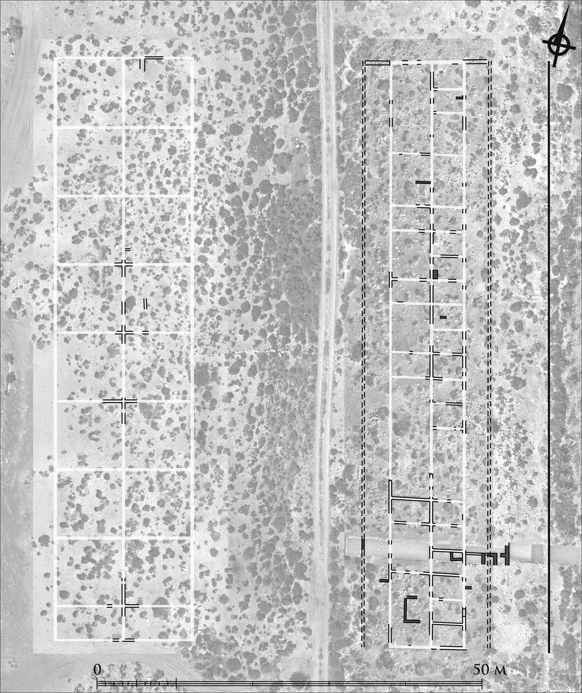
Fig. 5. Orthophoto map of buildings in area W5 (left) and W1 (right). For legend, see Fig. 3. (Courtesy of the Polish Center of Mediterranean Archaeology; orthophoto and drawing by M. Gwiazda and M. Łuba.)
No installations or artefact assemblages were discovered during excavations in the area of buildings W1-A and W1-B that could be used to identify their original functions. This is due both to the fact that people have long settled in this area and to the structural modifications that took place during the Early Islamic period (the second half of the 7th c. and the first half of the 8th c. CE).Footnote 18 In this later phase, these buildings were adapted to the needs of later generations of residents. This included raising floor levels, adding smaller units to the buildings, closing up the porticoes and adding rooms on the east side. A different type of building material, crushed limestone, was used in these alterations, which makes it easier to distinguish between the Early Byzantine and Early Islamic phases.Footnote 19
The analysis of orthophoto plans of buildings W1-A, B and C – verified by the test trenches – identified recurring modules inside the structures. Each module consisted of three cellular rooms on the east side and two on the west side (Fig. 5). Each had a square layout, with sides 10.2 m long. Eight such layouts were found to have been replicated inside building W1-B and at least eight within W1-A. Due to the fact that a large part of building W1-C was covered by the earth excavated during our work, only two modules could be identified.
Buildings in area W5
No excavations were carried out in the complex comprising buildings W5-A, B and C, located on the west side of the monumental street (ST2). Nevertheless, based on orthophotos of the surface, it was possible to deduce that the buildings were designed using a method similar to that described above (Fig. 5). Base squares with dimensions of 9.1 m were used in the design of these structures. The modular units were found on both the western and the eastern sides of each of the three buildings identified here. The presence of columnar porticoes on the north–south axis has not been confirmed in this case. However, it seems likely that they were there, particularly on the side facing the town's main street (ST2). Porticoes on both sides of this thoroughfare would have formed a columnar street, which was one of the more characteristic elements of eastern Mediterranean urban planning.Footnote 20
Buildings in areas W2 and W4
Another two complexes of modular buildings (W2 and W4) were located immediately adjacent to the western waterfront and flanked the double bath complex T2 to the west and east. Much of building W2 was excavated in the 1970s by an Egyptian team led by F. El-Fakharany.Footnote 21 They created a first, idealized plan of one of these buildings that suggested that it was laid out on a rectangular plan. Orthophotos taken at the site helped verify this hypothesis and showed that building W2 was in fact built on a plan that resembled a trapezoid (53.2 by 16.6 m, excluding porticoes) (Figs. 6 and 4B). This was due to the builders’ intention to adapt the eastern part of this building to the different urban grid on the eastern side (Fig. 2).
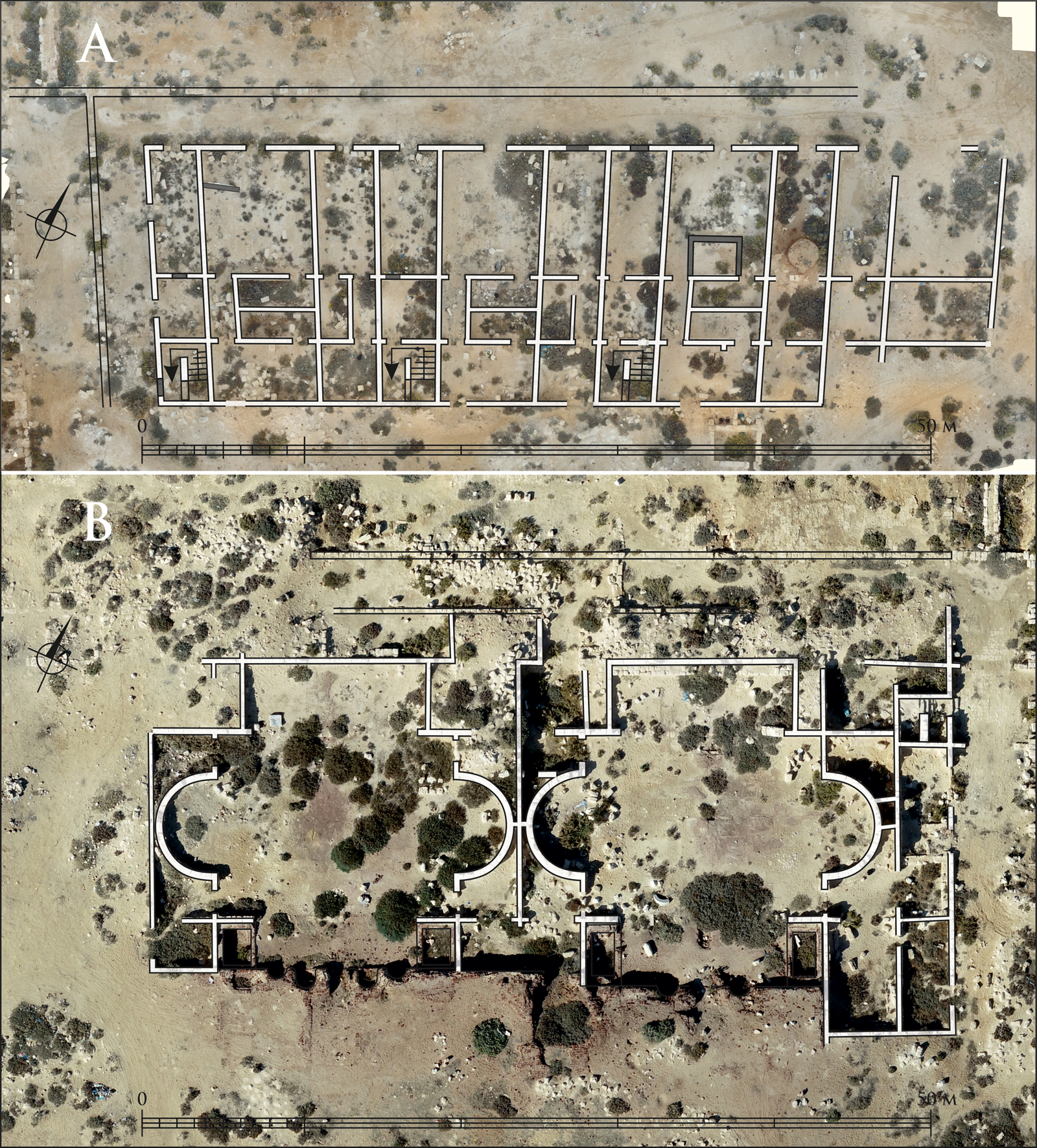
Fig. 6. A) Orthophoto map of building W2; B) Orthophoto map of bath complex T2. For legend, see Fig. 3. (Courtesy of the Polish Center of Mediterranean Archaeology; orthophotos and drawings by M. Gwiazda.)
The Egyptian team believed that the building was used for shops/workshops.Footnote 22 This suggestion was most likely based on the discovery of a kiln made of bricks in one of the rooms on the east side. However, it cannot be ruled out that this installation was a later addition as part of modification works similar to those identified in building W1-B. Reports from the excavations do not describe any other objects discovered in building W2 that could assist in determining its original function.
On the side of the lake and to the west, building W2 was delineated by a corniche and an adjoining street that ran perpendicular to it. Running parallel to these was a stylobate with pillars that marked the course of two porticoes (north and west). An architectural module that was replicated four times within the structure could be seen among the rooms located behind the stylobate. On the north side of the building was a large space (depth 8.1 m) flanked by two elongated rooms. A similar layout was also used in the south wing (depth 8.1 m), only mirrored. Several additional partition walls were erected there, creating smaller rooms and staircases.
Building W4, located on the west side of bath complex T2, has never been excavated. However, based on the layout of walls visible on the surface of the site, it was observed that this structure had a layout similar to that of W2. One difference was that it was rectangular in shape, due to the orthogonal layout of neighboring buildings and streets.
Bath complex T2
A double thermal bath complex was located between buildings W2 and W4. The northern part, which featured frigidaria (Figs. 6 and 4D), had previously been excavated by an Egyptian team.Footnote 23 This part of the bath complex was built from limestone pseudo-ashlar masonry, while the unexcavated caldaria located on the south side were mostly constructed from baked bricks.Footnote 24 The layout of the frigidaria in bath complex T2 is identical to that of the Great Bath at Abū Mīnā, built during the reign of Justinian.Footnote 25 The complex at Philoxenite differs from the original in that it featured two frigidaria (each 23.8 by 19.6 m) that were exact copies of each other. The existence of dual facilities most likely stems from the practice of separating men and women in public buildings, which become stricter in Late Antiquity. The same has also been found in other bath complexes in the Mareotis region.Footnote 26
Area DD1
The use of mirrored plans was also identified to the west of the dense urban area. A building referred to by various researchers as a dry dock can be found here.Footnote 27 This interpretation is questionable and could not be confirmed from the verification works done in this area. It was, however, possible to identify in this location two walls that continued into the water of the lake; the southern extension of these walls forms a channel that separates two identical wings of a building (each approximately 33.6 by 31.2 m) (Fig. 7). Each building consisted of four rows of rooms, where the remains of limestone slab floors were discovered. The identified remnants of walls were erected with limestone pseudo-ashlar masonry in courses of equal height (opus isodomum).
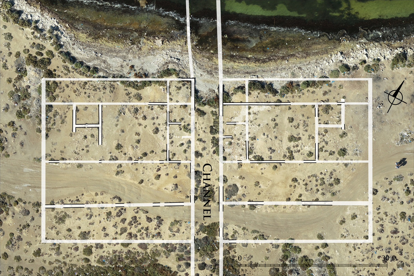
Fig. 7. Orthophoto map of building DD1. For legend, see Fig. 3. (Courtesy of the Polish Center of Mediterranean Archaeology; orthophotos and drawings by M. Gwiazda.)
Modular design in Roman and Early Byzantine cities
Cellular shops, which became widespread in the Mediterranean region from the 2nd c. BCE onward, are an excellent example of modular design.Footnote 28 They were usually constructed along streets in combination with columnar porticoes, or on public squares and in macella (Fig. 8A and 8B).Footnote 29 They may have consisted of a single room with an entrance on the street, although there were often additional compartments in the back. They were erected in clusters of several to a dozen or so units, with the rooms at the front of the building usually of identical size. Buildings of this type were erected exclusively in urban settlements until the Early Islamic period. This type of cellular room can be found in the eastern parts of buildings W1-A, B, and C in Philoxenite. However, identifying them as shops beyond all doubt would be unjustified, as there is no information available regarding their original furnishings.Footnote 30
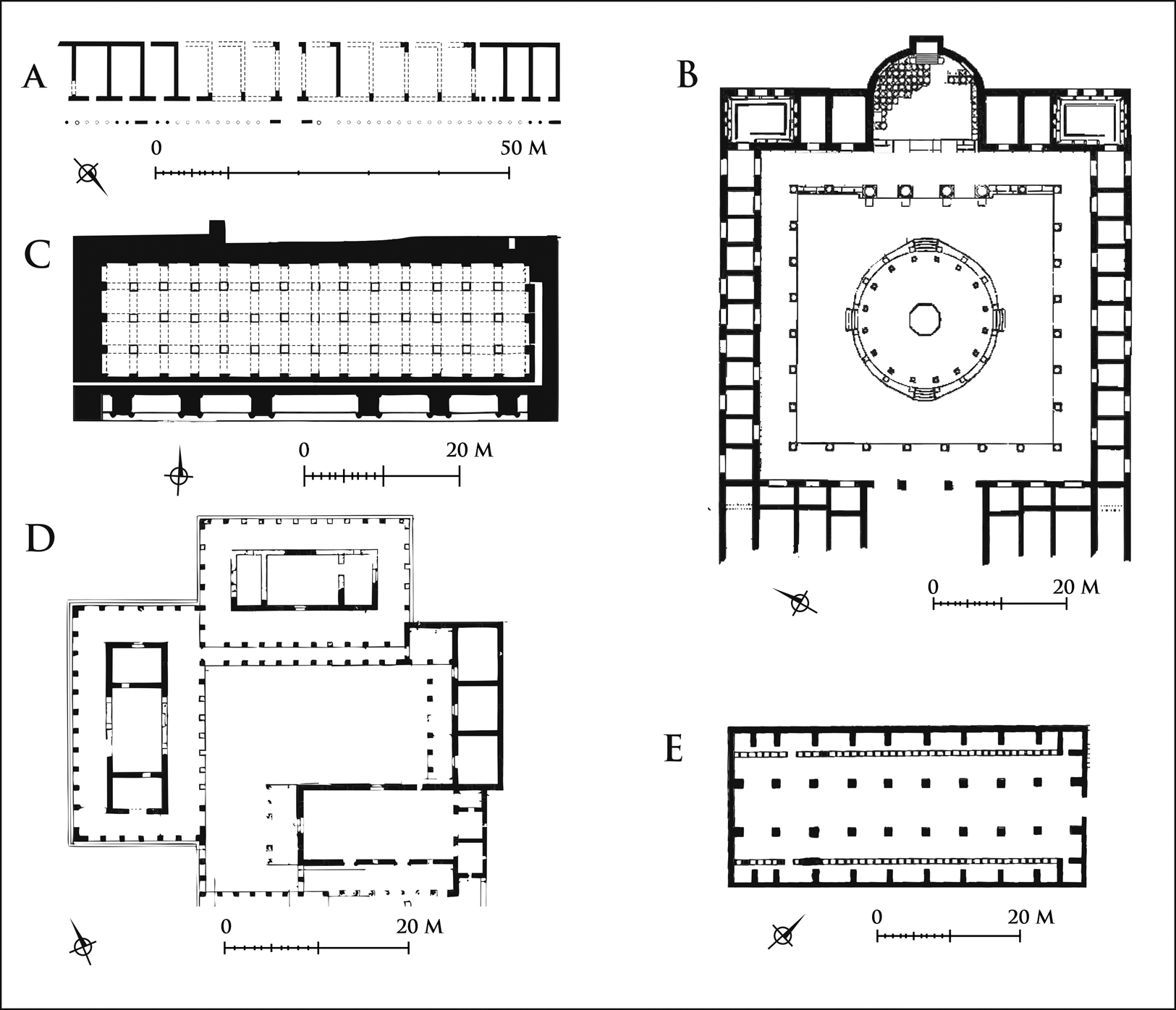
Fig. 8. Examples of Roman and Early Byzantine modular buildings from different parts of the Mediterranean. A. Cellular shops at Abū Mīnā (after Grossmann Reference Grossmann2004, fig. 1, with modifications by M. Gwiazda); B. macellum at Puteoli (after Maiuri Reference Maiuri1934, 29, fig. 13, with modifications by M. Gwiazda); C. modular cistern at Loutron, Salamis (Constantia) (after Stewart 2015, fig. 4.c, with modifications by M. Gwiazda); D. inns at Deir Seman (after Butler Reference Butler1920, fig. 284, with modifications by M. Gwiazda); E. pilgrims’ hostel at Tebessa (after Christern Reference Christern1976, fig. 21, with modifications by M. Gwiazda.)
The concept of a replicated module was also used in the design of military barracks, storerooms, and water cisterns.Footnote 31 Granaries were often created by combining several large rectangular rooms with independent entrances.Footnote 32 In Classe, the port of Ravenna, at least 18 unconnected warehouses with identical layouts were erected in the early 5th c. CE. They were arranged in an orderly fashion along canals and the street, which indicates that their construction was part of a wider project.Footnote 33 Some of these buildings consisted of a warehouse space proper, built on a square plan and flanked by porticoes on two sides, like structures found in area W1 in Philoxenite. The function of the structures in Classe was identified based on the huge number of amphorae imported from other regions of the Mediterranean that were found there.
In the Monastery of Abba Nefer in Manqabad (Middle Egypt), dating to the 5th–6th c. CE, a set of rooms stretching over 230 m was recently discovered. The building was divided into 46 units of 20 by 5 m. They had similar layouts and were identified as monks’ cells.Footnote 34 This example might provide yet another point of reference for the Philoxenite architecture. However, the complex has not been published in its entirety, and the excavators who discovered it noted themselves the presence of at least four cell variants within that building. Therefore, for now, caution should be exercised in referring to structures from the Manqabad monastery as examples of modular design.
Monumental cisterns, which combined multiple square or rectangular modules separated by pillars or columns (Fig. 8C), constitute the final parallel between Philoxenite and other Roman and Early Byzantine settlements. They can be found in various locations including Early Byzantine Alexandria, near Philoxenite.Footnote 35 As noted by C. A. Stewart, the use of modular design in the construction of cisterns and granaries enabled architects to visualize and estimate the capacity of such structures at a theoretical level and adapt it to suit peoples’ needs.Footnote 36
This review indicates that the modular building technique was primarily used in structures associated with trade and storage. It is poorly attested in the case of private residential complexes. Moreover, modular design seems to have been used in larger public and sometimes military construction projects.
Early Byzantine pilgrimage infrastructure in the Mediterranean
In the context of the specific function of Philoxenite, the secular buildings associated with Christian pilgrimage sites should also be examined. Understandably, archaeological research in such locations has often focused on uncovering churches. The Isaurian shrine of St. Thekla in Meriamlik, enlarged in the 5th c. CE by Emperor Zeno, is a good example of such a site. The structures identified in this area are primarily several churches, with a bath complex and a large number of cisterns.Footnote 37 However, it is unknown what was located in the spaces between these structures.
We have slightly more extensive knowledge of the sanctuary of St. Simeon Stylites the Elder in northern Syria, which underwent development after Simeon's death in the second half of the 5th c. CE. Some 30 rectangular buildings were identified on both sides of the processional road leading to the sanctuary, each of which was identical in form, according to D. Pieri. However, excavations have taken place in only two of these buildings, which is insufficient to confirm whether these structures were, in fact, uniformly designed. This archaeological work has nevertheless helped establish that two of these buildings were used as shops in the 6th and early 7th c. CE.Footnote 38
Thanks to an inscription in Greek, two inns (pandocheia) for pilgrims were identified in the village of Deir Sem'an (Telanissos), located at the foot of the mountain where St. Simeon was venerated. Both were erected in 479 CE, and they were identical in form. The inns were two-story buildings built on an elongated rectangular plan, surrounded by porticoes (Fig. 8D). The interiors of the buildings were divided into three rooms, with some of the space being used as stables. These buildings were adjacent to a monastery with a chapel.Footnote 39 The fact the structures were erected in the same year, had the same shape, and had porticoes that were partially interconnected suggests that they were built as part of a single project, based on a duplicated design.
A building which J. Christern believes served as a hostel for pilgrims was located in the sanctuary of St. Crispin's in Tebessa, Algeria. The hostel had an elongated rectangular shape, and its interior was divided into three parts (Fig. 8E). The central part contained a spacious room with pillars, flanked by two rows of cellular rooms with mangers. The rooms for the pilgrims themselves were located upstairs.Footnote 40
Similar modular structures can be found among the uncovered remains of the Abū Mīnā sanctuary. Numerous cellular rooms were identified by Grossmann along the monumental street leading up to the tomb of St. Menas (Fig. 8A). Each room had the same dimensions and was fronted by a portico.Footnote 41 Taken together, they formed a straight section of a larger building that was certainly erected as part of a single construction project. These rooms were identified as shops, based on their form, although there is no archaeological evidence to support this assumption. There were certainly many more similar units along the monumental street in the sanctuary, but a large portion of the site has not been fully uncovered.
Cellular rooms have also been discovered in a semi-circular building located on the south side of the Basilica with St. Menas's grave. The building also featured latrines, a portico, and stairways leading upstairs.Footnote 42 Although the layout of this structure does not incorporate identical modules, a mirrored set of several rooms is evident in its southeastern part. It is believed that the building was certainly erected for the use of pilgrims, although there is no archaeological evidence that would allow its exact function to be pinpointed.
Mirror images were also used in the design of the west wing of the Great Peristyle Building at Abū Mīnā. Its components include two peristyles separated by a corridor and two rows of rooms separating this part of the building from another peristyle on the eastern side.Footnote 43 It has been theorized that this building was used as an overnight shelter for pilgrims, but this is only speculative and based on the purpose of the site as a whole.
The uniqueness of Philoxenite
This review of modular buildings found in Mediterranean cities and secular structures found at pilgrimage sites yields two observations. First, in terms of their architectural concept, which involved replicating components to form a larger whole, the buildings discovered in the northern district of Philoxenite are part of a building tradition with strong roots in the Roman and Early Byzantine periods. Despite this replication in their design, the buildings identified in Philoxenite are original in their layout, and no exact counterparts have been found at other sites. Moreover, no other locations have been discovered where modular design was used on such a large scale, which is testament to the unique nature of Philoxenite. There can be no doubt that nearby Alexandria was home to well-trained master builders, who had the knowledge required to design and build Philoxenite in accordance with the theoretical framework of modular design. Among these experts, to give one example, was a certain Chryses, a mechanikoi who was responsible for the construction projects commissioned by Emperor Justinian.Footnote 44
The second observation is that no secular buildings with such a uniform design have been discovered at the various other sites associated with Christian pilgrimages dating to the 5th and 6th c. CE. This demonstrates that a universal architectural approach was not used in the construction of sanctuaries and the associated settlements that served them all around the Mediterranean. Moreover, the similarities in architectural plans are very limited at a regional level. The thermal bath complex at Abū Mīnā, which was copied and duplicated in Philoxenite, is an exceptional example of this phenomenon. Broadly speaking, there are no further close similarities between these two sites in terms of the design method of specific buildings, which is most likely due to the differences in how they were founded. The sanctuary of St. Menas developed between the 4th and the early 7th c. CE, as part of many separate investment projects. As a result, the architectural development of the site was far from homogeneous, explaining the irregularity of the town plan. Subsequent construction phases were more organic than coherent and organized, although there is no shortage of straight-line structures in the town.Footnote 45
Test trenches in Philoxenite indicated that the town was constructed as part of a single, centrally managed construction project. This should have resulted in greater control over the layout of the settlement, which has been confirmed by archaeological research in the area. This type of project enabled the erection of large and very regular structures that were not restricted by existing buildings and only needed to conform to the general town plan. According to the Encomium of St. Menas, the settlement was primarily created to provide accommodation to pilgrims. Pilgrim infrastructure must therefore have constituted the most distinct part of the settlement. This hagiographic text indicates that hospices, rest houses, and depositories for clothes and baggage/offerings were erected in Philoxenite during the reign of Justinian. From this information, one may assume that some of the modular buildings found at the site were used for this function. Obviously, it cannot be ruled out that individual structures served multiple purposes, for example, both as accommodation for pilgrims and as shops.
New urban settlements like Philoxenite were a rarity during the Early Byzantine period.Footnote 46 Furthermore, the site is a testament to the circumstances and nature of the community that founded it, rooted in the growing importance of pilgrim traffic on the way between Alexandria and the sanctuary of St. Menas. Philoxenite's designers were able to satisfy the demand for services generated by these pilgrimages by using efficient modular designs to build infrastructure that served pilgrims on an extensive scale.
Acknowledgements
This paper was made possible thanks to Lanckoroński Foundation fellowship. The archaeological works were financed by the National Science Centre, Poland [Grant number 2017/25/B/H3/01841].


 Open access