


Despite the long occupation of the cities of North Africa at least until the 7th c. CE, and the notable conservation of their ancient remains, research has mainly focused on the cities of the 4th c. CE, their reconfiguration in the Vandal period (5th c. CE), and the ChristianizationFootnote 1 and militarizationFootnote 2 of urban centers in the Byzantine period (6th–7th c. CE). The topic of urban hydraulics in particular has seen little systematic work in the region. Water is an essential resource for permanent settlement and a concern for survival during sieges. However, its availability varies according to geographical and climatic conditions, as well as the technical and financial resources invested in its distribution. Studying water access as a crucial component of urban transformations provides a different perspective on Late Antique African cities.
Water use in Roman cities has been the subject of many studies, especially concerning the Imperial period.Footnote 3 However, diachronic perspectives have been neglected and studies on water in the Late Antique world have only recently expanded their focusFootnote 4 beyond RomeFootnote 5 and Constantinople.Footnote 6 Some major questions remain to be answered regarding North African cities.Footnote 7 Were aqueducts still functioning in this period? How were fountains and baths maintained? How were urban settlement and water supply reorganized? To what extent were elements of hydraulic infrastructure intentionally integrated within city walls? The management of such infrastructure is also a concern: how were constructions and restorations carried out, and by whom? How did ancient societies adapt to changes over time and the hazards of climate, from both a local and a Mediterranean perspective? Furthermore, our interpretation of the availability of water resources must be shaped by the lived experience of past societies. How were waterworks perceived in Late Antiquity?
When water in the Late Antique period is studied, hydraulic infrastructure is generally treated in the same way as any other monument: the main focus is on the state of preservation, the use of spolia, the decoration, the inscriptions, or – in the case of bath complexes – the transformations of rooms.Footnote 8 Even if the idea of how water was used in monuments is mentioned, it is rarely related to larger water networks. Yet baths, fountains, and houses were part of a wider system, and even cisterns were dependent on a water supply, whether from rainfall or aqueducts.
This paper assesses the extent to which Late Antique societies managed the water supply of cities by maintaining or transforming preexisting hydraulic networks. It adopts topographical, technical, economic, and cultural perspectives while considering selected case studies of cities with different topographies and occupation phases at least until the end of antiquity. The approach employed here is to establish the “hydraulic topography” of citiesFootnote 9 by analyzing the chronological and spatial distribution of the hydraulic infrastructure throughout its phases of operation and abandonment. Using archaeology or epigraphy, this method allows one to identify the latest evidence for the functioning of the water monuments and, when possible, their date of abandonment. This approach makes it possible to determine which urban areas still had a water supply and whether water was provided by an aqueduct or by the collection of water via wells or cisterns. These elements must be considered in relation to the topography of the cities: if data relating to the elevation of the structures is not systematically recorded, the hypsometry of the sites confirms the possibility of gravity flow and the supply to the various locations studied. Moreover, it is worth putting the archaeological data into conversation with the testimonies of literary and legal sources that are much richer for the Eastern Mediterranean but that – with the usual precautions – deserve to be compared with the situation of western cities. The economic and administrative conditions in the provinces and cities changed throughout Late Antiquity, altering the context of urban infrastructure management as well as technical and construction capacities. The sources referring to Justinian's politics of construction and restoration, especially in the reconquered cities, mention hydraulic structures. Their message is significantly different from that still read in the inscriptions up to the 4th c. CE and testifies to a new conception of urban hydraulics.
In this study, I will draw on recent work carried out on Late Antique cities in North AfricaFootnote 10 and on the published evidence available for hydraulic infrastructure, supplemented by field observations from Sbeitla, in order to develop a hydraulic topography. My focus is the Byzantine period in North Africa from the early 6th to the late 7th c. CE. For the majority of North Africa, the mid-6th c. corresponds to the Byzantine reconquest by Justinian and is regarded as the beginning of a new political period with a more complex security context; cities were considerably transformed in this period and deserve individual, in-depth study.Footnote 11 For the beginning of Late Antiquity, which corresponds to the 4th and the early 5th c., the context of water has been well studied in North Africa. BathsFootnote 12 and fountainsFootnote 13 are known to have been restored or newly built, based on both archaeological and epigraphic evidence. However, from the 5th c. onward, inscriptions are very scarce. Most of the inscriptions known after that date are either funerary (Christian) inscriptions or dedications of city walls.Footnote 14 Regarding water, there is no epigraphic data from the 5th c. onward.Footnote 15
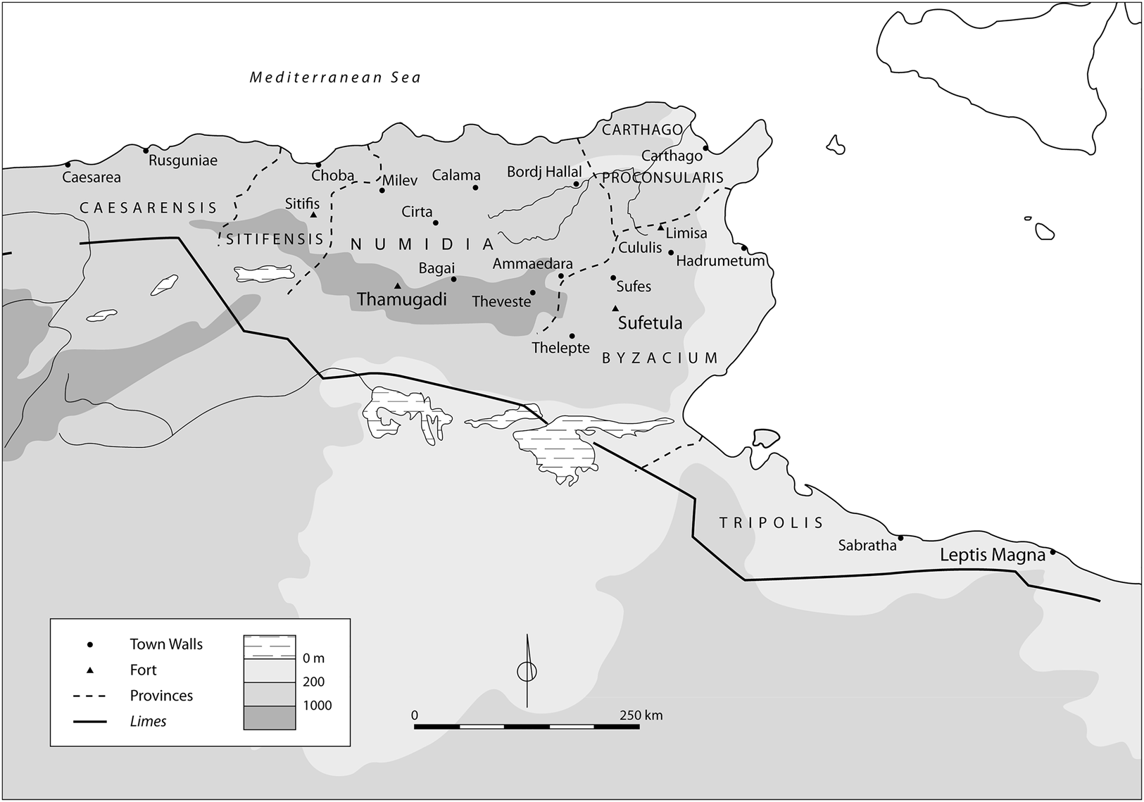
This paper is based on three case studies (Fig. 1): Leptis Magna, a fortified harbor city in Tripolitania; Sbeitla (anc. Sufetula), an inland city of Byzacena with several fortified locations; and Timgad (anc. Thamugadi), a city in Numidia at the foot of the Aures Mountains, which included a fortress at its edge. Each of these cities has a different topography, but all are known to have been occupied at least until the end of antiquity (6th–7th c. CE). All three cities were equipped with an aqueduct in the 2nd c., and several of their water monuments are dated to Late Antiquity. Only by taking a long-term perspective is it possible to understand changes and developments in water management, as well as the resilience capacity of societies.Footnote 16 The data, however, are scarce and should be used with caution because of the age of the excavations and a lack of earlier interest in the Late Antique structures. The transformations of baths and fountains are poorly documented, as are those of aqueducts. The objective here is to gather the available data on the Byzantine period and to stimulate reflection on the water supply in Late Antiquity.
Map of Byzantine North Africa showing major sites, including those studied in this paper. (After Pringle Reference Pringle1981, map 3.)
Based on these case studies, this paper will address several aspects of water management. First, although Carthage has been investigated,Footnote 17 the maintenance of aqueducts and other hydraulic monuments into Late Antiquity needs to be evaluated in other North African cities. Here, we need to think specifically about the elaboration of new strategies and the adaptation of hydraulic infrastructure at the end of antiquity. More broadly, questions concerning the relationship between urban settlement and access to water need to be considered, particularly in the context of fortifications. Second, this relationship is also associated with the continuity of city administration and management, the economic capacity of communities, and the technical knowledge and availability of skilled workers – all of which need to be assessed. Third, few questions have been raised concerning the perception of water-related monuments during this period. Although the representation of the city is a quite well-studied topic,Footnote 18 in Late Antique texts and inscriptions, mentions of the restoration of infrastructure and the construction of fortifications could be both rhetorical formulas and reflections of ancient realities, as the archaeological remains demonstrate. This paper argues that the hydraulic networks inherited from the Early Roman period were in some cases preserved while at the same time greatly modified or adapted to new uses and new security, technical, and environmental constraints, thereby illustrating the resilience of Late Antique societies.
Leptis Magna: flooding, an enclosing wall, and the reorganization of water access
The Wadi Lebda, which flows through Leptis Magna, is dry for part of the year and there is no spring near the town. Until the 2nd c. CE, the inhabitants used only private wells and cisterns, as well as a group of reservoirs near the wadi.
In 119–20 CE, the euergetes Q. Servilius Candidus provided the city with water by way of an aqueduct built at his own expense.Footnote 19 The spring of this aqueduct has been identified at the Wadi Caàm, 19 km away, and two pipes leading to Zliten have been identified on the western bank of the river.Footnote 20 The aqueduct's channel ended in the northern cistern alongside the Wadi Lebda (Fig. 2).Footnote 21 A second cistern was located 150 m further south.Footnote 22 Originally independent, these two cisterns were later connected by an aqueduct that then crossed the river on a bridge and ran along the left bank. The construction of Candidus' aqueduct was made possible by the erection of a dam across the Wadi Lebda, which directed the water toward the Wadi Rsaf to the northwest. The city end of the aqueduct route is not known, but it probably reached the cisterns located near the Baths of Hadrian (Fig. 3). Another stretch of aqueduct was located farther north on the right bank of the Lebda: it could correspond to a diversion of the aqueduct from the northern cistern to supply the city's eastern districts. Perhaps it should be identified together with a potential cistern, a quadrangle with dimensions similar to those of the two cisterns near the wadi farther to the south, visible on the right bank on the topographical surveys of the beginning of the 20th c. at the level of the Baths of Hadrian on the left bank.Footnote 23
Plan of Leptis Magna and its surroundings in Late Antiquity. (After Mattingly Reference Mattingly1995, fig. 6.1.)

From these cisterns, I would suggest that two supply branches supplied the city center (Fig. 3). One headed toward the theater and supplied the palaestra of the Baths of Hadrian, the West Nymphaeum of the Chalcidicum (7), and the Lacus of the theater (2). The other passed through the latrina, which was later transformed into the Nymphaeum of Hercules (3), supplied the Augustan market, and ended its journey in the baths that preceded the “unfinished baths” near the coastline.Footnote 24 Some other fountains are known and could date from the same time as the building of the aqueduct.Footnote 25
Plan of Leptis Magna in the Byzantine period. Fountain numbers refer to Tomasello Reference Tomasello2005. (After Di Vita et al. Reference Di Vita, Di Vita-Évrard, Bacchielli and Polidori1998, 51, and Mattingly Reference Mattingly1995, fig. 6.1.)
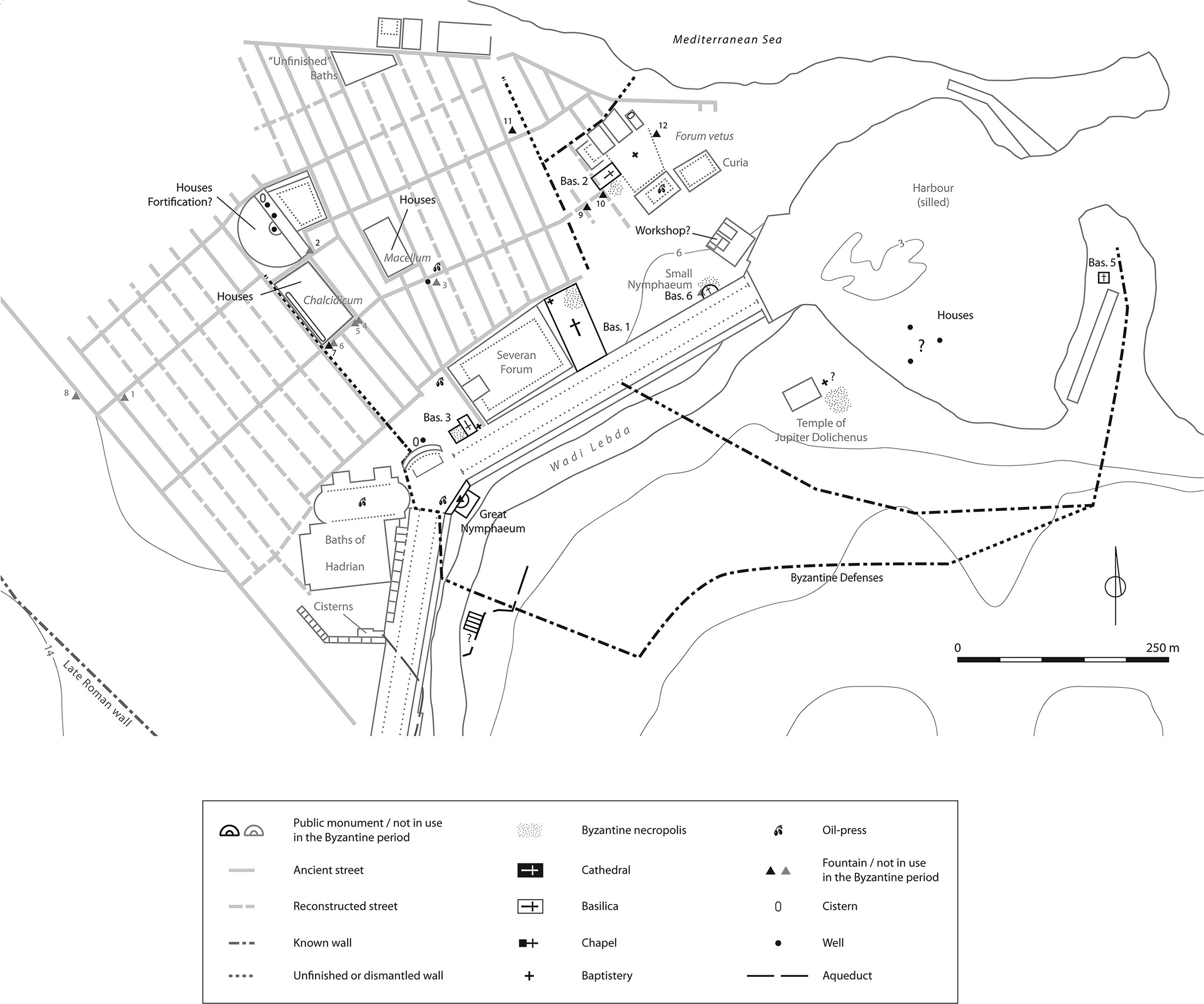
The Severan period was characterized by a large-scale, planned construction project initiated by Septimius Severus, a native of the city. In addition to the Great Nymphaeum and the Small Nymphaeum, built along the Via Colonnata (Fig. 3), additional fountains were built or restored in the 3rd c. though others ceased to function. The network that had been set up in the previous century was therefore still intended to ensure the supply of water to most of the city. The construction of the cistern in the Chalcidicum portico (Fig. 4), dated to the 3rd c. CE, presumably benefited from the aqueduct that passed through this area; the cistern would have played the role of a castellum for the district.Footnote 26 The Great Nymphaeum could have been fed via two large cisterns added at that time to the series located near the Baths of Hadrian.Footnote 27 The channel of the aqueduct identified on the right bank could have fed a Severan construction identified with the baths located behind the temple of Jupiter Dolichenus, baths which may later have been restored by Justinian.Footnote 28
Leptis Magna, the cistern of the Chalcidicum, looking north. (Courtesy Jorge Tutor.)

The city was long considered to have been affected by earthquakes during the course of the 4th c. CE but recent research has shown that the earthquake of 365, in particular, did not impact the city.Footnote 29 In fact, the interruption of the aqueduct, for a long time attributed to these events, occurred a bit later. It must be ascribed to a break in the dike that enabled the Wadi Lebda to resume its course: this damaged the aqueduct and alluvium invaded part of the Via Colonnata and the Baths of Hadrian; the harbor and the nearby Eastern Baths; the theater and its porticus; the Serapeum (Figs. 3 and 11), and the Forum Vetus.Footnote 30 The oldest flood deposit has been radiocarbon dated to 320–440 ce,Footnote 31 but the chronological span can be reduced to the years 355–440 because the Baths of Hadrian were still functioning from ca. 355–61, when they were restored.Footnote 32 After the pipeline was broken by the flow of the wadi, the cisterns of the Baths of Hadrian stopped receiving water, interrupting the supply to the rest of the city. An important modification of the Great Nymphaeum was the transformation of the trapezoidal platform into a basin (Fig. 5). This layout could date to the 4th–5th c., when the water supply stopped, but it is also not impossible to attribute it to the Byzantine period.Footnote 33
Leptis Magna: plan of the Great Nymphaeum. The semicircular basin and the platform turned into a basin are highlighted. (After Ward-Perkins 1993, fig. 40, and Pucci et al. Reference Pucci, Pantosti, De Martini, Smedile, Munzi, Cirelli, Pentiricci and Musso2011, fig. 2.)

The situation changed considerably during the Byzantine period, in terms of both urban occupation and water supply (Fig. 3). The alluvial deposits carried by the Wadi Lebda flooded many streets and squares, as can be seen from the Byzantine-era structures built on these levels.Footnote 34 Procopius attests to the silting up of the city by the time Justinian's troops arrived and also alludes to the city's desertion by its inhabitants following a first invasion by the Lawatan Berber tribe between 527 and 533 CE.Footnote 35 This raises the question of whether the street network was preserved. Although no longer used to the same degree as during the Imperial period, its grid pattern might still have been visible.Footnote 36 A wall was built during the reign of Justinian that reduced the city to a small area near the shore from the old eastern mole to the Severan basilica and up to the temples of the Forum Vetus. A wall enclosing a larger area remained unfinished, leading from the mole toward the Great Nymphaeum and the Chalcidicum.Footnote 37 Near the Christian basilicas, several of which dated back to the 6th c., oil presses were installed in urban space and tombs are attested within the walls, mainly near places of worship.Footnote 38 Settlement did not stop, given that dwellings also developed around the craft and religious facilities, creating apparent clusters of activity both inside and outside the city walls.Footnote 39 Tripolitania, though, seems to have experienced a major change in living standards earlier than other parts of North Africa.Footnote 40
Wells and cisterns are documented within these settlement areas, and these provided for the water needs of the population. Several wells have been identified in the harbor area of Leptis Magna close to the eastern mole – filled with ceramics dated from the late 5th CE to the third quarter of the 7th c. CEFootnote 41 – and in the theater.Footnote 42 Whereas one well was located behind the great Severan exedra, which was possibly settled in Late Antiquity,Footnote 43 another was dug at the corner of the streets facing the Nymphaeum of Hercules (Fig. 3.3), probably after its abandonment.Footnote 44 In addition, three cisterns are recorded: one in the theater, which may have housed not only inhabitants but also soldiers,Footnote 45 one behind the great exedra,Footnote 46 and one in the podium of the Temple of Hercules-Melqart on the Forum Vetus.Footnote 47
Two fountains in the Forum Vetus may also date to Late Antiquity or even to the Byzantine period (Fig. 3). One (10) is located along the street near the Basilica (2) and is thought to be a Byzantine construction based on the use of murex in its mortar.Footnote 48 The fountain would have been fed by a distribution system in use during the Justinianic period, which was not necessarily the same system as that of the Early Roman period.Footnote 49 Another fountain near the eastern portico (12), placed directly on the pavement and including many spolia, is thought to have been built in a rather late period.Footnote 50
These fountains, built or restored in the Byzantine period, raise the question of a continuous water supply.Footnote 51 The restorations of the West Nymphaeum of the Chalcidicum (7) have also been dated to the Byzantine period because of the use of murex. This nymphaeum was fed from the rear reservoir via the Chalcidicum cistern.Footnote 52 Francesco Tomasello has suggested that the pipe supplying this area of the city was still working and was protected by the southern Byzantine wall that would have followed the street linking the plaza of the Great Nymphaeum to the theater.Footnote 53 However, at least on the left bank of the wadi, it is difficult to reconstruct a supply from the aqueduct considered to have been destroyed by the floods. In this case, the nymphaeum of the Chalcidicum no longer operated as a fountain pouring out a continuous stream of water, but, fed by a rainwater collection cistern, it had to either let water run from an overflow or deliver it through a tap. In any case, dating structures to the Byzantine period by the use of crushed murex is not reliable: the technique, long identified in the fortifications,Footnote 54 has also been identified in the latrines located behind the Baths of Hadrian, dated to the 2nd–3rd c. CE.Footnote 55 Archaeological observations seem insufficient and only archaeometric analyses will provide answers to this question.
The state of preservation of the Great Nymphaeum in the Byzantine period is poorly understood. The monument was included in the initial planning of the Byzantine wall, no doubt because it could have played the role of a tower. The destruction of half the structure, however, could be attributed to the flooding of the wadi in the 6th c. CE,Footnote 56 or earlier. If the nymphaeum was no longer supplied by the aqueduct via the Baths of Hadrian's cisterns, then its two basins played the role of rainwater storage – a kind of improvised cistern.Footnote 57
However, an aqueduct may have supplied water until a later period in time. In the 1950s, excavations of the southern Byzantine wall on the right bank of Wadi Lebda uncovered the conduit of an aqueduct at the bottom of tower B.8, which ran through an arch in the wall (Fig. 6).Footnote 58 This feature presupposes that the aqueduct was working and was still delivering water when the wall was built, or at least that it had been restored shortly after the Byzantine reconquest.Footnote 59 The origin of this aqueduct, however, raises several questions. This branch could be identified with the one that ran along the right bank of the wadi. Either it was associated with the two large cisterns that received water from the Wadi Caàm ‒ although these were largely silted up at the beginning of the 6th c. ‒ or it was connected to the third possible cistern on the right bank, still functional and fed by the same aqueduct of the Wadi Caàm. The destination of this branch is not known. It could have served the eastern districts of the city, and although it has not been excavated, it was possibly built as early as the Antonine period, when the Wadi Lebda was channeled. It could have supplied a Severan bath rebuilt by Justinian, as mentioned before.
Leptis Magna: passage of an aqueduct under the Byzantine walls next to tower B.8. (After Goodchild and Ward-Perkins Reference Goodchild and Ward-Perkins1953, 63.)

Sbeitla: scattered fortifications, a pipe network, and the remodeled distribution of the water supply
Sbeitla is known for its Late Antique phases as a result of the important studies on the Christian basilicas.Footnote 60 An aqueduct is identified coming from the north of the city, probably supplied by the spring of the Wadi Sbeitla (Fig. 7). An inscription reused in the aqueduct-bridge provides a terminus post quem for its construction in the mid-2nd c. CE.Footnote 61 A few branches of water pipes, attributable to the period of the aqueduct's construction, have been identified in the central part of the city.Footnote 62 A large part of the hydraulic network may have been modified in the course of the 4th c., at a time when the city was evolving.Footnote 63 The latest epigraphic information about water monuments concerns the construction of at least oneFootnote 64 and possibly three – monumental fountains,Footnote 65 and the restoration of the Great Baths in the late 4th c.Footnote 66
Plan of Sbeitla in the Byzantine period. (After Duval Reference Duval1982, fig. 10, and Lamare Reference Lamare2017, fig. 16.)

Around the 5th c. CE,Footnote 67 the so-called Édifice des Saisons – a rich house where a mosaic is dated to the early 5th c. – was decorated with two nymphaea. Concerning the bath complexes,Footnote 68 the baths (10) attached to the Basilica (2) are thought to have been built in the early 5th c.,Footnote 69 and the small baths (26), which were probably private, present a mosaic dated to the 5th–6th c.Footnote 70 The baths (10) had a cistern, the dimensions of which, however, make it unlikely that it could have been supplied solely by rainwater collection.Footnote 71 In contrast, neither the small baths (26) nor the Édifice des Saisons had a storage device. In all three cases, it is therefore necessary to assume an external supply of running water.Footnote 72
Among the water monuments of Late Antiquity, the northern fountain, the construction of which is supposed to have taken place in the middle of the 4th c. CE (as is the case with two other, rather similar, fountains in the city), deserves special mention. Its original design may have included a second basin, which has now disappeared. The existence of the second basin is suggested from the model of the other fountains on the site and on the basis of a study of the preserved basin and the reworking of the pavement of the courtyard.Footnote 73 In a later phase, which could have been as early as the 5th c., this second basin may have been torn out, and the remaining basin transformed into a distribution basin. The holes drilled into one of its balusters could have accommodated pipes that redistributed the water to different sectors of the city (Fig. 8).Footnote 74
Sbeitla: holes in the balustrade of the northern fountain. (Lamare Reference Lamare2017, fig. 15.)

The urban situation seems quite stable until the Byzantine conquest, but important changes occurred in the late 6th c. CE (Fig. 7).Footnote 75 Noël Duval has suggested that streets were filled, blocking the Early Roman grid at least around the domus ecclesiae (Basilicas 1 and 2) and the southeast district, where oil presses were located. Although changes of level are attested in some places and could be related to the filling of streets (Fig. 9), research on this subject will have to be further pursued in the preserved areas given that most of the streets were completely cleared at the beginning of the 20th c. without any concern for stratigraphy. Another major modification is the construction of fortifications that are, unfortunately, undated but are heterogeneous in their building techniques: the amphitheater, the northern temple, and the forum were fortified, and “fortified houses” were built.Footnote 76 The city was still inhabited. Duval assumes there were clusters of settled activity around fortifications or fortlets and churches, sometimes associated with oil presses. However, this image of the city is very incomplete and only reflects the excavated areas.Footnote 77
Sbeitla: raising of the threshold testifying to the elevation of the street level. The upper parts of the wall are restored. (N. Lamare, 2019.)

In the two southeastern fortified houses, wells that enabled the occupants to be relatively self-sufficient are attested. The northernmost fortified house also had at least one cistern, whereas two adjacent rooms coated with tile mortar could have been used for water storage.Footnote 78 The baths (26) may still have been in use. In the domus ecclesiae, works are attested until the 7th c. CE,Footnote 79 which raises the question of the functioning of the baths. To the northwest, the Édifice des Saisons and the adjacent house may still have been in use as part of a cluster built near the fortifications of the amphitheater and the old temple. However, the fountain to the southwest of the forum may possibly have been converted into a dwelling during this period.Footnote 80
The inventory of these hydraulic structures implies the presence of water but due to the lack of excavations we cannot assess the extent to which a large-scale distribution network might have supplied the different areas of the settlement. Was the aqueduct still in use? There are no archaeological or epigraphic data to answer this question. However, these water monuments would not have been able to operate without a perennial water supply in the city.Footnote 81 It should be noted that our lack of knowledge about the housing situation throughout the history of the city makes it impossible to identify any wells or cisterns that might have complemented or even replaced a water supply system. To the northeast of the forum, the discovery of a modest basin that cannot be dated and, above all, of a box with three openings that housed lead pipesFootnote 82 – the bottom of which is composed of a reused Byzantine epitaphFootnote 83 – indicates that a system of water distribution under pressure continued at the end of the Byzantine period and even into the beginning of the Arab-Muslim period.Footnote 84 As for the urban context, although our knowledge is limited, we can see that the mastery of hydraulic techniques was also pursued during a later time period. It is therefore possible to consider the continuity of water distribution, but through networks different from those of the Early Roman Empire.
Timgad: a water spring, a garrison, and the local security issue
At Timgad, numerous wells were dug as soon as the colony was established at the end of the 1st c. CE, which would have provided most of the water needs of private houses. The wealthiest households were provided with wells wherever the water table was present. The first supply works were carried out in 146.Footnote 85 At this time, the Ain Morri spring was tapped and transported to the city by a south‒north pipeline, a work that was completed in 174.Footnote 86 The Ain Morri spring was supplemented by drainage water from the Aqua Paludensis ca. 183–85.Footnote 87 In the 2nd c., a spring sanctuary was built to the south of the city (Fig. 10). Numerous alterations were carried out during the Severan period.Footnote 88 A large basin whose water supply was provided by a brick canal on the south wall was located in the center of the spring sanctuary. Pipes coming from the southeast and the southwest have been identified around the sanctuary. Water then passed from the basin through a viridarium and continued further north.Footnote 89
Plan of Timgad in the Byzantine period. (After Courtois Reference Courtois1951, inset pl.)

No specific information is available on the city's water supply in the 4th c. CE. The latest evidence concerns the baths, which were particularly numerous in the Roman period in this small city.Footnote 90 The baths (5) of the Donatist Cathedral were part of an ensemble dating back to the late 4th–early 5th c., with possible modifications during the Byzantine period.Footnote 91 In the North Small Baths (1)Footnote 92 and the South Great Baths (3),Footnote 93 mosaics were restored from around the 5th to 6th c. according to stylistic evidence. The encroachment of the North-East Small Baths (2) on the street indicates a relatively late dating and implies the disuse of the city wall that cannot be earlier than the Severan period. The Byzantine style of several capitals would also indicate a late date, or at least a long period of use.Footnote 94 Despite the lack of data, mosaic restorations with terracotta similar to the pilae tiles of the hypocaust stacks could indicate a rather late use of the South Small Baths (4), which are also very close to the Byzantine fortress.Footnote 95 The water supply for these baths is not known, but no cistern has been identified in the studies that have been completed thus far. The supply would have remained very dependent on the highly developed water supply network in the city of the Early Roman period,Footnote 96 and it must be assumed that it still functioned, at least partially, until quite a late date.
Construction or restoration activities can therefore be identified up to the 5th c. CE, and sometimes, up to the 6th c. (Fig. 10). The Christian buildings confirm the continuity of the city's life in the Byzantine period. These include the chapel of the Byzantine fortress (9) with its basin,Footnote 97 the Donatist cathedral (7) with its fountain supplied by a pipe coming from the southern part of the courtyard,Footnote 98 possibly the Catholic cathedral (2),Footnote 99 the two chapels (5–6) near the Capitol,Footnote 100 and the Basilica (3) of Januarius in the city center.Footnote 101 The chapel (10) of Gregory the Patrician, built by John of Tigisi between 641 and 647, is the latest construction attested in the city.Footnote 102 There is no evidence that Timgad, in contrast to what Procopius indicates, was “emptied of its population by the Moors and razed to the ground”Footnote 103 in 484. The inscription mentioning the reconstruction of the town referred primarily to the fortress.Footnote 104
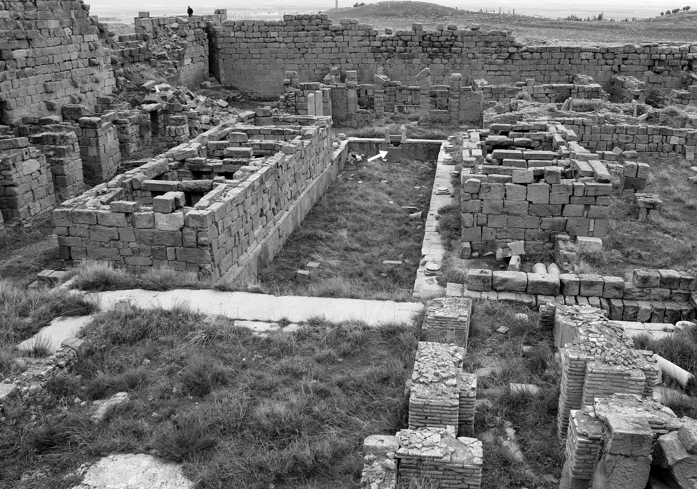
In fact, an interesting and important feature of the hydraulic infrastructure of the Byzantine period is the reuse of the Aqua Septimiana pool to the south of the city (Fig. 10). The period between 214 CE and the inauguration of the fortress in 539–40 CEFootnote 105 is not really known. But at that time, the sanctuary was destroyed, and the basin was enclosed in the new Byzantine fortress. The choice of the site was certainly influenced by the presence of water. Jean Lassus indicates that walls built on the sides of the original basin were intended to increase the storage capacity of this tank. He observes, however, that the well-preserved overflow on the north face, which still fed structures outside the fortress, appears to contradict his interpretation (Fig. 11).Footnote 106 In any case, it must be noted that the remodeling carried out on the basin and the hydraulic installations that benefited from its supply attest to the availability of water and therefore to the functioning of the supply from the spring catchment.
Timgad, basin of the Byzantine fortress viewed toward the north. Note the overflow indicated by an arrow. (Xiaotong Gao, 2015, CC BY-SA 3.0.)
Among the other water structures of the fortress (Fig. 12), a basin was situated next to the north gate, which was approximately 4 m deep and kept partly above ground and partly below. No supply or discharge openings have been identified on this basin. Rainwater could have been collected from the roofs, or water might have flowed from the nearby baths, because pipes have been identified in the street in between.Footnote 107 The fortress, in fact, included small baths (6)Footnote 108 consisting of eight rooms and five fairly small basins. The water supply for these baths has not been identified, although the idea of a supply from the nearby spring basin is briefly mentioned by Lassus.Footnote 109 No other possibility for the filling of the baths can be suggested: no cistern is identified in these baths, except for the aforementioned reservoir located near the gate of the fortress, which would have benefited from the water supply of the spring via the baths. Despite the small volume of the basins, manual filling seems to be excluded, especially given that access to the baths was from the east, opposite the spring basin.
Plan of the Byzantine fortress of Timgad. Hydraulic structures are highlighted. (Lassus Reference Lassus1981, inset pl.)

North of the fortress, at the location of the former sanctuary, lead pipes fed two reused sarcophagi from the spring basin.Footnote 110 The sarcophagi served as fountain basins. The fountains may have been built before the 6th c. CE and were only refurbished in the time of Justinian.Footnote 111 The restoration of the fountains in Byzantine times fits well with that of the basin at the same period.
What role did the sanctuary pool play in supplying the city? The pipes seem to continue northward toward the southern baths, but data are scarce. However, it should be remembered that Roman baths were discovered under the viridarium of the Severan sanctuary.Footnote 112 It is likely that the spring water was collected and used at that time in this area. Perhaps it was also used to supply the southern part of the city, whereas the Ain Morri supplied the theater area and the northeastern quarters.
The fortress, probably settled in the first place because of the perennial spring and the basin, may also have attracted urban occupation during the Byzantine period. In fact, most of the churches attested in this period are located southwest of the original city and even south of the fortress, as are three of the baths (3, 4, 6) active in the Byzantine period (Fig. 10). The area between the city and the fortress has not been excavated, but it seems clear that it was occupied. Furthermore, the structures to the north of the fortress, which must be attributed to the Byzantine period, indicate that the population sought the protection of the fortress when it was still occupied by a garrison or when it became a protective environment for a village.Footnote 113
Of course, the evidence for churches and fortifications, largely overexploited in the study of Byzantine urban topography, cannot be used to conclude that the urban center had been moved. Although the housing is not well known in its latest phases, two baths may still have been active in the early town center, and the numerous wells could have provided access to the water necessary for domestic use. In the city center,Footnote 114 the presence of stables, some of which may be dated to the Byzantine period, is another testimony to the continuity of settlement in this area. However, the mention of the destruction of the town in 484 CE, even if exaggerated, hints at the possible abandonment of part of the primitive urban center. This is suggested by the reuse of the forum pavementFootnote 115 and by a privileged settlement in the south around the fortress and its spring that provided protection and subsistence.
Where was the water? Continuity and reorganization of hydraulic networks
In the cases studied here, the archaeological data alone allow us to identify several scenarios for hydraulic networks in the Byzantine period by identifying which monuments considered to be heavy water consumers were still in use at that time.Footnote 116 The absence of cisterns in baths implies an external supply, via an urban supply network, as in the case of several baths in Timgad. In any case, when a small cistern existed – for example, in the baths of the Basilica (2) in Sbeitla – the collection of rainwater was certainly not sufficient, and this cistern was only an intermediary with an external supply. It should be remembered, however, that the amount of water used in the baths could have been quite limited, but this is generally difficult to assess.Footnote 117
A more obvious indication would be the presence of fountains, which are designed to deliver a continuous stream of water that presupposes an uninterrupted supply upstream. However, there are differences in the sites studied. At Timgad, the fountains located outside the fortress, dating to the Byzantine period, consisted simply of reused sarcophagi with orifices, indicating the presence of a functional water supply. At Leptis Magna, the open-air basin of the Great Nymphaeum could have been used to collect rainwater like a cistern or to store water supplied, perhaps irregularly, by a pipe. In comparison, the nymphaeum (7) located at the end of the Chalcidicum cistern is not an obvious testimony to the functioning of a perennial water supply.
The hydraulic network must be evaluated as a whole, including the situation of springs and aqueducts. In Timgad, the spring that rose up near the south of the city was still able to supply the basin from which its water was collected; that basin was restored during the Byzantine period. It is not known, however, whether the Ain Morri spring and the conduit that led its output to the city were still in use. In Sbeitla, the continued existence of the spring until the present day suggests that it has never dried up. However, we must be wary of simplistic conclusions because we still know little about the climatic changes in the southern Mediterranean in antiquity.Footnote 118 At Leptis Magna, the analyses conducted on the alluvium carried by the Wadi Lebda have made it possible to revise the dating of the destruction of the aqueduct,Footnote 119 long attributed to the earthquake of 365 CE. This represents another type of natural event for which knowledge must be deepened for ancient North Africa. In Carthage, for instance, Arab sources indicate that the aqueduct was in use until its destruction at the end of the 7th c., which was confirmed by the ceramic deposits in the Cisterns of La Malga.Footnote 120 It had been restored under the Severan dynasty, then probably during the Byzantine period, before being renovated under the Hafsids, as evidenced by the different construction techniques and confirmed by archaeometric analyses.Footnote 121 The discovery at Leptiminus of a coin of Constans II in the mortar ‒ dated to 643–47 and used to block the main conduit of the eastern aqueduct in order to divert the flow toward the branch feeding the cisterns near the Eastern Baths ‒ indicates that the water supply through this conduit was still functional at least in the middle of the 7th c.Footnote 122 However, these modifications point out that the water supply was no longer directed toward the center of the ancient city but instead toward this eastern area, around the baths, which were no longer in operation as such.Footnote 123
Studies in Asia Minor have shown that the water supply in Late Antiquity seemed more targeted, whereas central distribution points, represented by Archaic to Hellenistic fountain-houses, had lost their importance. In several cases, the public function of fountains was even annihilated by pipes that redistributed water directly to consumers, houses, or shops.Footnote 124 In spite of the absence of precise data on the aqueduct, in Sbeitla, there are several indications that water was still flowing through the town: on the one hand, through the existence of a pressurized network and, on the other hand, due to the fountain in the northwest, which attests to a redistribution of water through pipe connections on the balustrade of its basin. In Timgad, either two different systems supplied the city and the fortress, or the city had a limited and irregular supply from the aqueduct, which ensured the supply of the small baths and prompted the installation of the fortress near the spring for strategic reasons, leading to the development of a settlement in the surrounding area. In the case of Leptis Magna, the supply of the Chalcidicum cistern by an aqueduct remains unclear. In any case, no pipe has been identified that indicates that it served as a redistribution node for the surrounding areas. Most dwellings met their water needs from wells and cisterns.Footnote 125 It appears, however, that the area of the Forum Vetus, encircled by a Byzantine wall, may have held several fountains that did not exist during the Imperial period and the supply of which had to be ensured by a reorganization of water distribution. No wells have been identified in this area so far. In another context in the Western Mediterranean, the same phenomenon of reorganization of urban settlement based on the availability of water has been highlighted in Visigothic Spain.Footnote 126
The redistribution of water to preferential areas of activity within a city raises a question about the nature of the archaeological documentation at our disposal. The identifications of “clusters of activity” in SbeitlaFootnote 127 and of a “leopard spot” settlement pattern in Leptis MagnaFootnote 128 are based on the very partial results of excavations. However, Byzantine occupation is identified in most of the excavated areas, most often corresponding to the public monuments of the Early Roman Empire that attracted early archaeological attention. Even though there is no doubt that the rest of these cities were occupied during the Imperial period – an idea supported by the presence of an extensive network of roads – the hypothesis of Byzantine occupation over this entire area has rarely been formulated.Footnote 129 The topographical representations of Byzantine settlements are therefore misleading, and the problem of street obliteration only makes them more complex – i.e., are the alluvial deposits that covered part of the streets of Leptis MagnaFootnote 130 and the heightening of the streets of SbeitlaFootnote 131 indications of the disappearance of the street network? This line of questioning has encouraged reconstructions of scattered zones of activity, not connected by a street system,Footnote 132 even though these elevations, from 50 cm to 1 m (Fig. 9), did not systematically make the maze of roads invisible.
The accessibility of water must also be considered in relation to the security conditions of cities and their fortifications. To do this, it is necessary to distinguish between types of fortifications and the water needs related to them. The fortifications commonly called fortlets were mainly intended to accommodate small mobile garrisons.Footnote 133 The supply of drinking water for men and horses was ensured by the presence of cisterns identified in most of the forts in the High Steppes region.Footnote 134 In Sbeitla, the fortified houses to the south of the town were equipped with wells or cisterns. The other fortifications could benefit from the water supplied by the aqueduct.Footnote 135
The fortresses of larger dimension accommodated stationary garrisons whose strength could vary. In the case of Timgad, the number of men in the garrison was estimated at between 250 and 300.Footnote 136 Citadels or walls surrounding towns were intended to protect the population in the event of a siege. The situation was no longer just military but civilian, no longer mobile but stationary.Footnote 137 In the latter two cases, a large quantity of water had to be easily and continuously accessible to withstand long sieges. The poliorcetic literature of the Byzantine period refers to these needs.Footnote 138 In the case of Timgad, the basin that gathered water from a nearby spring and whose presence must have dictated the installation of the fortress has already been mentioned. The presence of dwellings installed around this fortification, the population of which could have benefited from protection in the event of an attack, cannot be excluded.
At Leptis Magna, however, the aqueduct that supplied the town on the left bank of the wadi had not been working since the years 355–440 CE. The wells and cisterns were certainly already developed at the time of the construction of Justinian's wall. Because the cistern of the Chalcidicum was still functional, supplied either by rainwater collection or via a pipe, the initial project of the wall had to include it to facilitate the supply inside the enclosure. The reduced wall – the one that was actually completed – would have entailed the development of wells and cisterns in the area of the Forum Vetus while preserving a functional conduit on the right bank. However, the chronology of the development of the fortifications and water resources is uncertain: the Byzantine wall built around the harbor could be justified by the existence of a settlement that was clustered near its water supply by wells and that was engaged in various craft activities during the last century of Byzantine presence.Footnote 139 The question of the anteriority of the fortification or of the water supply cannot clearly be evaluated in the absence of precise dating elements, but the two phenomena are surely interdependent.
The importance of easy access to water is confirmed by the springs, cisterns, wells, or aqueducts reported near many fortifications.Footnote 140 In the case of Haidra, in addition to the cisterns long identified below the citadel, a perennial spring at the edge of the wadi immediately outside the fortification probably played a role in the choice of its location.Footnote 141
Water under control? Hydraulic management and technology
The numerous transformations of hydraulic infrastructure, sometimes on a large scale when aqueduct channels or large public cisterns were involved, presuppose the existence of an authority capable of supervising such projects at least at a local level. As mentioned above, there are hardly any inscriptions in Africa beyond the beginning of the 5th c. CE that provide information on the financing and the officials involved in the management of hydraulic infrastructure. From this date onward, it is mainly legal sources that provide information on the management of water and monuments.
A series of imperial rescripts from the 5th c. CE sheds light on the situation of the city of Constantine during the Vandal era. We learn that a delegation of inhabitants of Numidia and Mauretania Sitifensis went to the emperor with several petitions, including one dealing with illegal water intakes from the aqueduct.Footnote 142 This claim indicates that the aqueduct was still functioning, given that water intakes were made there, meaning that its maintenance was assured. The rescript of 445 CE also shows that the aggrieved inhabitants probably sought to remedy the lack of local public authority due to the insufficient number of curiales in the cities after the departure of many prominent citizens from the province of Numidia in the wake of the Vandal conquest.Footnote 143
The paucity of information provided by the Digest about water management outside Rome and Constantinople indicates that city administrations played a leading role in this issue. Consequently, one must consider the persistence of local water magistrates and, probably, regional or even local regulations as during Early Roman times.Footnote 144 The argument supports a continuity in the administrative activities of the cities, which assumed responsibility for water management. In Ostrogothic Italy, many aqueducts and baths were repaired, but the nature and source of the funds to pay for these operations are not known. Although Theodoric himself financed some restorations, routine maintenance was the responsibility of the local authorities. The technical and administrative means were therefore the same as those used in previous centuries.Footnote 145 The part taken by the Church in the management and financing of water infrastructure, as in the rest of city maintenance, is attested in some casesFootnote 146 but remains much debated,Footnote 147 so examples from the Eastern Mediterranean can be extrapolated neither to the West nor to Africa.Footnote 148
Economic considerations must be taken into account, even if we are very poorly informed about the funding sources for major buildings, such as churches and luxurious private baths, of the Byzantine period in contrast to the sources available for the Near East at the same time.Footnote 149 When restorations were limited – such as in the case of Timgad, where the water supply was still provided by the spring and only the basin needed to be repaired – the human and financial resources were sufficient (even more so here because the army was involved). In Sbeitla, the prosperity of the city is attested by the numerous constructions of Christian cult buildings and, on the administrative and political level, it has been suggested that the city became the residence of the dux of Byzacena.Footnote 150 Assuming that the aqueduct was still functioning, perhaps thanks to minor repairs over time, the transformation of fountains and the installation of additional pipes in the city did not raise any financial difficulties. These proactive measures taken to manage the water supply and its eventual scarcity can be understood as a sign of urban vitality rather than the parallel process of an irretrievable decline.Footnote 151 However, it seems that when the damage was too severe, for example following violent events, the economic capacities were no longer sufficient to restore the entire system. This was probably the case at Leptis Magna,Footnote 152 which could not cope with the silting up that began ca. 355–440 CE after the breaking of the dam of the wadi. Whereas the dynamism of Vandal–Byzantine urbanism was sufficient to transform and remodel parts of the cities, it was unable to handle the entirety of the formerly occupied areas.Footnote 153 Hydraulic infrastructure certainly suffered from this maintenance problem.
One might consider the loss of technical knowledge or specialized manpower to be factors influencing water management. However, some texts testify to a very real know-how and interest in the field of irrigation. Procopius evokes the mastery of hydraulic installations in a passage that refers to Solomon's campaigns in 539–40 CE.Footnote 154 The notarial deeds that are recorded in the Albertini tablets, dating to the Vandal period, also evoke the control and management of water for crops. Archaeology has, moreover, highlighted the development of hydraulic techniques linked to the exploitation of the landscape up to the Byzantine period and, precisely in the region of the Tunisian High Steppes, the importance of Late Antique dams has recently been highlighted – for example, at Kasserine and Sbeitla.Footnote 155 In an urban context, it has been shown that the decline in the number of engineers and their disappearance in the Western Mediterranean was visible in the constructions of the 6th–7th c. CE. However, in the Eastern Mediterranean and in the western territories reconquered by Justinian, there is some evidence in favor of the presence of state-protected engineers. These engineers were associated with major projects, such as those of Theodoric in Italy or the construction of a new aqueduct at Reccopolis by Leovigild in the 5th c. The latter, however, is one among very few other examples from that time.Footnote 156 The continued functioning of aqueducts depended on the interest of the elites in this type of restoration and on continuous maintenance, but it could not be ensured by major reconstructions or restorations.Footnote 157 Four of the aqueducts in Rome, for example, were kept in use until the end of the Middle Ages. The aqueducts were used to supply mainly episcopal complexes and water mills in addition to the baths of churches or charitable institutions, and perhaps even the Baths of Caracalla. The repairs, implemented by the Byzantine administration and then, from the end of the 8th c., by the papacy, copied the techniques of the Roman period.Footnote 158
Security or scarcity? Perception of water resources
Restorations or new installations for hydraulic supply testify to a willingness (and a need) to make the access to water possible in cities, whether fortified or not, close to places of activity. This reorganization of hydraulic networks reveals either a poor adaptation to a decaying urban hydraulic system or a great capacity of communities to adapt and react flexibly with regard to urban facilities.
Up until the 4th c. CE, numerous African inscriptions mention the restoration of monuments, particularly those with a hydraulic purpose. Insistence on the lack of maintenance and the restored functioning of such monuments, mentions of the incuria of previous generations, and transformations carried out for the well-being of the people are elements of a rhetorical stance that was, nevertheless, most probably based on material realities.Footnote 159 In the 6th c., in contrast, the inscriptions do not evoke this type of restoration but instead focus almost exclusively on the construction of fortifications.Footnote 160
Literary sources, mainly concerned with the Eastern Mediterranean, provide essential information on the strategies implemented and on the perception of urban water transformations. Procopius's De Aedificiis is a major source. The references relating to hydraulic engineeringFootnote 161 emphasize the economic advantages of water resources, making cisterns and reservoirs a positive tool through which emperors could create abundance out of scarcity. Similarly, in many 5th–6th c. CE chronicles of Constantinople, the pattern of open pools and cisterns becomes recurrent. The proliferation of these structures within walls indicates a need for security.Footnote 162
Despite a few references by Procopius to Africa, Evagrius Scholasticus provides a more important testimony for this discussion: in this region, Justinian restored many cities and adorned them with various public buildings and walls, as well as with “water-conduits both for essential need and beauty.”Footnote 163 These monuments were built from scratch when the cities did not have them, or they were repaired “and brought back again to their ancient order.”Footnote 164 The rhetoric analyzed by Yves Modéran consists of a return to the “classical city” ‒ a city that the learned pictured very clearly, particularly due to their classicizing culture.Footnote 165 Two inscriptions recently found in Algeria – the oldest known to date before the Byzantine reconquest – confirm that the municipal ideal was still vivid until the mid-5th c. CE.Footnote 166
Yet, archaeological sources show us that the hydraulic system, in particular, was never restored to its Early Imperial condition. In fact, the elites restored an “idea of the city” from the Classical period, based on bookish knowledge, while adding new characteristic elements – particularly walls, which became an essential component of the urban ideal in the Byzantine period.Footnote 167 For the people, who did not have access to this knowledge of the past, there was no personal memory that could go beyond two or three generations. The contemporary state of the city and its waterworks was a fact, and only inscriptions – if they existed – or imperial or local political discourse provided certain images of the past. Evoking the idea of decline or simply transformation only makes sense when long-term knowledge is possible. The testimony of Cassiodorus shows that in 6th c. CE Italy, the ideal of the classical city was still strong and the pleasures of bathing were an integral part of urban life.Footnote 168
Authorities still used water as an essential symbol of their power but, as opposed to the images of profusion and the “eternity of water”Footnote 169 associated with other water monuments during the Early Roman Empire, cisterns became structures worthy of praise in Procopius's text,Footnote 170 which testifies to an important change in the perception of water resources and their management. In these examples from the Eastern Mediterranean, that power insisted on the storage of water and its guaranteed availability. Despite a decline in the implementation and maintenance of hydraulic infrastructure, people perceived their city as safe and their governing elites as protective. North Africa certainly experienced this paradigm shift as well.
Conclusion
The late use of aqueducts can be traced by identifying the operation of hydraulic monuments up to a late date. This approach only provides a terminus ad quem that must be clarified where possible by stratigraphic excavations to identify the phases of abandonment, and by archaeometric analyses of carbonate deposits found on the aqueducts and other potential hydraulic buildings.Footnote 171
An aqueduct conduit needed to be in a certain condition for the water to flow properly, including both an unbroken path and a sufficiently well-maintained internal conduit.Footnote 172 Even if such networks were still functional, their condition was not the same as that of the original networks: the distribution of water was different within the urban space, depending on the supply branches that were still in use. The state of preservation or restoration of the pipes may have conditioned the development of housing or fortifications in certain areas of a city. Craftsmen and inhabitants were also able to manage their water needs by means of wells or cisterns and, in some cases, transformed the network to supply workshops and houses by taking water from cisterns or old fountains transformed into redistribution basins. The topography of Byzantine African cities must, however, be reevaluated so that researchers are not misled by plans representing the results of partial excavations. The correlation between urban settlement and water availability should then be emphasized.
The situation of each city was unique, depending on its importance, its administrative and economic context, and the natural events it experienced. The presence of a Byzantine garrison in Timgad facilitated the works that were carried out by the army, whereas the prosperity of Sbeitla, visible in the construction of Christian basilicas, indicates that the repairs probably did not pose a financial problem, although the origin of the funds – possibly the Church – is not known. The more difficult circumstances in Leptis Magna, as in the province of Tripolitania in general, which faced numerous attacks from tribes from the hinterland and the progressive silting up of the city and the port, were such that complex and costly repairs had to be limited in this city, which had been partially abandoned before the arrival of the Byzantine troops. Even if manpower and technical knowledge had not been lost, the cities themselves or their elites had to ensure the financing of the hydraulic infrastructure and their economic and administrative situation did not necessarily allow them to attend to the most important works.
Notions of decline and continuity may be nuanced and analyzed from individual, subjective perspectives. Even if one cannot determine the former point of view – given that the sources, which are already few in number, reflect the mentality of the learned elite – it must be borne in mind that the image that the inhabitants themselves had of their city could not have been built on a very old referent. The identification of hydraulic systems, even limited ones, in working order, shows the adaptability of the populations facing unexpected events, which must be further analyzed.Footnote 173
The study of water requires a broader perspective than that of anthropogenic data alone. The construction of complementary branches of many ancient aqueducts has generally been interpreted either as an additional need for water, as a response to a decrease in flow, or as a drying up of the spring originally tapped to supply a city (for example, in Timgad). Archaeometric studies must come into play to improve our knowledge of natural data, including the analysis of the carbonate deposits found in the conduits. Study of the superimposition of the limestone layers deposited by the water flow and the analysis of the stable isotopes of these concretions will make it possible to enhance chronological precision regarding the duration of use. It will complement the information relating to the origin and flow rate of the water used in one or more aqueducts and allow reconstruction of the evolution of water resources and climatic conditions,Footnote 174 particularly at the end of antiquity,Footnote 175 which differed across the empireFootnote 176 and within the Maghreb.Footnote 177 Comparisons of the transformations highlighted by archaeology and natural data will enable an evaluation of the resilience of past societies in the face of slow climatic change as well as more violent events and will provide a new perspective on the urban world between Antiquity and the Middle Ages.
Acknowledgments
First versions of this work were prepared as part of a DAAD postdoctoral research grant at the Freie Universität Berlin and were presented in Berlin, Tübingen, and Paris. This article was written at Kiel University with funding of the Deutsche Forschungsgemeinschaft (DFG, German Research Foundation) under Germany's Excellence Strategy – EXC 2150 ROOTS – 390870439. I would like to thank François Baratte, Cristina Murer, and Roberta Ferritto, who reviewed the first drafts of this study; the anonymous reviewers of the JRA for their comments; and Eileen Küçükkaraca for revising the English text. All views and errors remain my own.


 Open access

