


Introduction
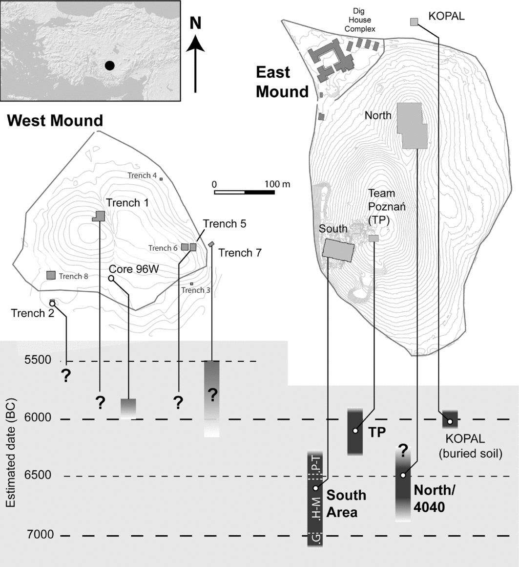
The Anatolian Neolithic tell (or Turkish höyük) settlement of Çatalhöyük was investigated by James Mellaart from 1961–1965, and by Ian Hodder and others from 1993–2017. Located on the Konya Plain, in central Turkey, Çatalhöyük is famed for densely packed houses, underfloor burials and a rich symbolic tradition observed over much of the approximately 1200-year sequence of the intensively studied East Mound. Less well known is Çatalhöyük's West Mound, which was the subject of smaller-scale excavations by Mellaart, and more recently (1998–2013) by various other teams. Situated approximately 200m from the East Mound (Figure 1) across a former course of the Çarşamba River, Çatalhöyük West has traditionally been viewed as a separate Early Chalcolithic occupation, commencing in the early sixth millennium BC, after the abandonment of the East Mound. Until now, it has been unclear whether there was an intervening hiatus between the occupations of the two mounds.
Çatalhöyük East and West, showing approximate previous dating estimates and uncertainty in the relationship between the mounds. Question marks without grey bars indicate estimates made in the absence of radiocarbon dates. (Plan courtesy of Çatalhöyük Research Project.)
Thirty-three newly obtained AMS dates presented here conclusively demonstrate overlap in occupation of the two mounds. Based on these, Çatalhöyük East and West should be seen as a single settlement whose focus of occupation shifted gradually, probably over one or two centuries, around the turn of the seventh to sixth millennia BC. The implications of this extend beyond Çatalhöyük, informing supra-regional models that link late seventh-millennium settlement disruption to rapid climate change, and challenging the conventional notion of prehistoric tell settlements as discrete, bounded entities.
Cultural change at Çatalhöyük
The Çatalhöyük sequence offers the impression of a continuous, large-scale Neolithic occupation, showing relative cultural and economic stability through the seventh millennium BC, until a rupture marked by disaggregation (e.g. Baird Reference Baird and Hodder2005: 69–74) and cessation of occupation on the East Mound—followed by apparently smaller-scale reoccupation on the West Mound during the Early Chalcolithic. Under this model, the absence on the West Mound of many ‘classic’ Çatalhöyük features—such as underfloor burials, wall paintings and bucrania (cattle skull installations)—along with the proliferation of painted pottery and the appearance of new architectural forms, could be taken as evidence of a major cultural break, perhaps caused by the ‘8200 cal BP rapid climate change event’ (see below). The narrative of seventh-millennium stability at Çatalhöyük, however, is called into question by recent research on the East Mound, which has produced evidence for substantial changes after c. 6500 BC (Hodder Reference Hodder2014). Meanwhile, excavations on the West Mound (Gibson & Last Reference Gibson and Last2003; Biehl et al. Reference Biehl, Franz, Orton, Ostaptchouck, Rogasch, Rosenstock, Hofmann, Moetz and Müller2012) and uppermost East Mound (Marciniak & Czerniak Reference Marciniak and Czerniak2007) have emphasised elements of continuity as well as change.
The East Mound: from continuity to change
Research at Çatalhöyük East has highlighted compelling evidence for a major shift in social organisation at c. 6500 BC (Hodder Reference Hodder2014), with a decrease in overall population and a shift from an agglomerated settlement structure to a looser arrangement with large gaps between house clusters. Houses became fewer in number but larger in size and of a more complex structure. Households started to manage resources with greater independence, coinciding with the abandonment of house-related practices that are argued to have promoted social cohesion between households (Düring & Marciniak Reference Düring and Marciniak2005; Hodder Reference Hodder and Hodder2013). From this, Hodder (Reference Hodder2014: 11) has concluded that social organisation was characterised by egalitarianism throughout the sequence, but that social differentiation, competition and economic specialisation became more pronounced after 6500 BC. This heralded a period of ongoing social change, with further significant developments—including the disappearance of underfloor burials—after c. 6300 BC (Marciniak et al. Reference Marciniak, Barański, Bayliss, Czerniak, Goslar, Southon and Taylor2015). The East Mound's population continued to decline, with its north eminence probably abandoned by c. 6300 BC; by 6000 BC, the only known buildings left in use were at the summit of the south eminence (the ‘TP’ (Team Poznań) area).
The onset of these changes coincided with an abrupt subsistence shift, including the first appearance of hulled barley (Bogaard et al. Reference Bogaard, Filipović, Charles, Fairbairn, Green, Fuller and Stroud2017) and a sharp decline in aurochs and equid hunting, offset by the increased contribution of domestic sheep, goat and the first clearly domesticated cattle (Russell et al. Reference Russell, Twiss, Orton, Demirergi, De Cupere, Linseele and Hamilton-Dyer2013). Herd mortality profiles hint at a shift from pooled herds to household-level management, fitting the broader picture of household autonomy, while stable isotope analysis of animal bones and biomechanical analysis of human bones suggest that mobility in the landscape steadily increased (Hodder Reference Hodder2014; Larsen et al. Reference Larsen, Hillson, Boz, Pilloud, Sadvari, Agarwal, Glencross, Beauchesne, Pearson, Ruff, Garofalo, Hager, Haddow and Knüsel2015). The latter, in turn, corresponds with the appearance of smaller, possibly seasonally occupied sites on the Konya Plain, such as Pınarbaşı B (Baird et al. Reference Baird, Carruthers, Fairbairn and Pearson2011).
The West Mound: from change to continuity?
Given increasingly clear evidence for dynamism at Çatalhöyük East, could the shift to a new location simply represent one development among many in a time of changing settlement practices, rather than a radical break with the past? By the late seventh millennium BC, occupation had already contracted from both eminences of the East Mound to just the southernmost. The subsequent or concurrent expansion at a third locus a few hundred metres west, albeit across a probable river channel, need not have been a major disruption to local lifeways, especially if gradual.
Continuity between the mounds is supported by new research at Çatalhöyük West (Anvari et al. Reference Anvari, Brady, Franz, Naumov, Orton, Ostaptchouk, Stroud, Willett, Rosenstock, Biehl, Steadman and McMahon2017). Many of the changes in material culture observed at the West Mound can be argued to have roots in the cultural trajectory of the East Mound. These include large, probably two-storey, buildings that can be linked to the rapid architectural changes seen in the TP area, and to further expansion of household autonomy. The distinctive painted pottery is also anticipated in the later East Mound sequence by the presence of new shapes and occasional decorated sherds (Last Reference Last and Hodder2005; Özdöl-Kutlu et al. Reference Özdöl-Kutlu, Carter, Czerniak, Marciniak, Hodder and Marciniak2015). Meanwhile, continuity indicated by subsistence data is striking (Russell et al. Reference Russell, Twiss, Orton, Demirergi, De Cupere, Linseele and Hamilton-Dyer2013), and the appearance of additional smaller settlements on the plain after c. 6000 BC (Baird Reference Baird and Hodder2005: 71–73) indicates acceleration of the Late Neolithic trend of greater mobility and more extensive landscape use.
Wider significance
Developments at Çatalhöyük took place within a dramatically changing late seventh-millennium cultural landscape. Following the widespread uptake of farming in Western and North-western Anatolia c. 6500 BC, an increasingly diverse cultural landscape developed in Late Neolithic/Early Chalcolithic Central, Southern and Western Anatolia, with innovations such as painted pottery and new crop and animal husbandry techniques exchanged between regions (Düring Reference Düring2011: 199, Reference Düring2013). The 8200 BP climate event has been posited as a cause for various social disruptions in Anatolia and beyond, including the East–West shift at Çatalhöyük (Weninger et al. Reference Weninger, Clare, Rohling, Bar-Yosef, Böhner, Budja, Bundschuh, Feurdean, Gebel, Jöris, Linstädter, Mayewski, Mühlenbruch, Reingruber, Rollefson, Schyle, Thissen, Todorova and Zielhofer2009: 33–34; Clare & Weninger Reference Clare, Weninger, Özdoğan, Bașgelen and Kuniholm2014; Clare Reference Clare2016: 178), although its effect on Central/Western Anatolian environments and settlement processes is debated (Asouti Reference Asouti2009; Flohr et al. Reference Flohr, Fleitmann, Matthews, Matthews and Black2016; Willett et al. Reference Willett, Franz, Kabukcu, Orton, Rogasch, Stroud, Rosenstock, Biehl, Biehl and Nieuwenhuyse2016; Ayala et al. Reference Ayala, Wainwright, Walker, Hodara, Lloyd, Leng and Doherty2017).
Çatalhöyük is central to these debates, and the shift in occupation is a recurring issue: was it abrupt, gradual or was there a hiatus? As long as the date of the foundation of the West Mound relative to the abandonment of the East Mound remains obscure, there can be no clear understanding of the translocation, what it meant for the community at Çatalhöyük, nor indeed of any relationship to climatic events and wider cultural developments. By starting to establish this chronological relationship, the new dates presented here pave the way for the construction of a unified settlement history of Çatalhöyük.
Previous dating at Çatalhöyük
The East Mound
Dating has concentrated on the higher southern eminence, where a 21m sequence divided into ‘levels’, XII (earliest) to 0 (latest), by Mellaart (Reference Mellaart1964), with the later addition of four ‘pre-XII’ levels (Cessford Reference Cessford2001), probably represents almost the entire duration of occupation. Based on 26 radiocarbon dates from levels XII–II, Mellaart (Reference Mellaart1978: 13) estimated an occupation of c. 7100–6300 BC. While his start date has proved remarkably accurate (Bayliss et al. Reference Bayliss, Brock, Farid, Hodder, Southon and Taylor2015), subsequent research has pushed the undated final levels steadily towards the end of the seventh millennium: Thissen (Reference Thissen, Gérard and Thissen2002: 324) suggests 6200–6100 BC, and Cessford (Reference Cessford and Hodder2005: 77) 6200–5900 BC; the latter taking into account erosion and late dates from a buried soil horizon in the off-site KOPAL excavation area (Table S1).
Recent excavations at the summit of the south eminence (the TP area), adjacent to the sequence detailed above, have finally provided dates for Mellaart's levels I–0 (Marciniak & Czerniak Reference Marciniak and Czerniak2007; Marciniak et al. Reference Marciniak, Barański, Bayliss, Czerniak, Goslar, Southon and Taylor2015). Abandonment of the latest-known domestic building (building 33) is now securely dated to 6015–5905 BC at 95% probability, with an 83 per cent chance that interments continued in a nearby burial chamber (Sp.428) after this point, while cessation of occupation is estimated as 5975–5865 BC at 95% probability, although two later dates from an overlying midden suggest that sporadic activity continued (Marciniak et al. Reference Marciniak, Barański, Bayliss, Czerniak, Goslar, Southon and Taylor2015: 172–73). More limited dating from shallower excavations on the north eminence indicate that it was abandoned by c. 6300 BC (Hodder Reference Hodder2014: 4; see Cessford Reference Cessford and Hodder2005; Stevanović Reference Stevanović, Tringham and Stevanović2012).
The West Mound
The West Mound has been the subject of several excavations, albeit much more limited in depth and extent than those on the East Mound. Mellaart's trenches—trench 1 close to the summit, and trench 2 towards the south-western edge (Mellaart Reference Mellaart1965)—were reopened and laterally extended between 1998 and 2003, along with two very small soundings (trenches 3–4) on the eastern peripheries (Last Reference Last1998; Gibson & Last Reference Gibson and Last2003). Three further trenches were excavated between 2006 and 2013: trenches 5–6 towards the top of the mound's eastern ‘shoulder’, and trench 7 nearby on the mound's easternmost edge (Biehl et al. Reference Biehl, Franz, Orton, Ostaptchouck, Rogasch, Rosenstock, Hofmann, Moetz and Müller2012). Finally, an eighth trench (trench 8) was excavated at the south-west of the mound (Erdoğu Reference Erdoğu2012).
The chronology of the West Mound has been contested from the outset. With no radiocarbon results available until 2002, estimates were subject to both revisions in the dating of the East Mound and conflicting perceptions of cultural and pottery sequences in wider Central Anatolia. In Mellaart's view, painted pottery dated Çatalhöyük West to the Early Chalcolithic I and II, indicating that it was “occupied after the desertion of the Neolithic site, perhaps from c. 5600 BC [uncalibrated]” (Reference Mellaart1965: 135), although he also remarked that unexcavated Late Neolithic levels could exist. Following the calibration of the East Mound dates, Mellaart adjusted this to 6300 BC, retaining his (never explicitly justified) hypothesis of a seamless transition: “Around 6300 BC the site of Çatal Hüyük was moved across the river, for some reason still unknown to us, and rebuilt as Çatal Hüyük West” (1978: 23). By contrast, French (Reference French1967) placed Çatalhöyük West at c. 5650–5500 BC (after calibration), opening up a gap of 650–800 years between the mounds. This hiatus has persisted in the literature, although estimates of length vary: Thissen (Reference Thissen, Gérard and Thissen2002: 324) tentatively dates Çatalhöyük West to 6000–5600 BC, only slightly post-dating the East Mound in his model, while Schoop (Reference Schoop2005: 129–31) argues for a four- to five-century hiatus, dating the West Mound to between 5700 and 5500 BC.
The first radiocarbon dates from the West Mound calibrate to c. 6000–5800 BC (Göktürk et al. Reference Göktürk, Hillegonds, Lipschutz and Hodder2002; see Table S1). Based on unidentified charcoal, these may be older than their context due to the old wood effect. Conversely, as they were recovered from approximately 250–400mm above natural alluvium in a core taken on the southern slope of the mound, they may not represent the earliest anthropogenic deposits, especially given the evidence for substantial colluviation in trenches 3 and 4 (Last Reference Last1998). Nonetheless, based on these and the KOPAL dates, Cessford (2005: 95) argues for “only a relatively brief interval between the occupation of the two sites, or possibly no interval at all”. Cessford's view has subsequently been supported by the TP dates (see above), although Weninger et al. (Reference Weninger, Clare, Rohling, Bar-Yosef, Böhner, Budja, Bundschuh, Feurdean, Gebel, Jöris, Linstädter, Mayewski, Mühlenbruch, Reingruber, Rollefson, Schyle, Thissen, Todorova and Zielhofer2009: 34) maintain that there is a “glaring 200-year gap”. Five dates from trench 7, three of which pre-date 5750 BC at 68.2% (Biehl et al. Reference Biehl, Franz, Orton, Ostaptchouck, Rogasch, Rosenstock, Hofmann, Moetz and Müller2012; Table S1), provide further support for continuity or even overlap between the mounds, but because of stratigraphic inconsistencies, these require reassessment (see below).
In sum, three models have been suggested for the East–West Mound transition at Çatalhöyük, each with different implications for the nature of social change:
1) Mellaart's hypothesis of an abrupt but seamless transition.
2) French's hiatus.
3) An overlap, tentatively raised by Mellaart and recently revisited in response to the first radiocarbon dates from the West Mound and uppermost East Mound (Marciniak & Czerniak Reference Marciniak and Czerniak2007: 123; Düring Reference Düring2011: 133; Biehl et al. Reference Biehl, Franz, Orton, Ostaptchouck, Rogasch, Rosenstock, Hofmann, Moetz and Müller2012: 59–60).
Of these, recent evidence militates strongly against an appreciable hiatus. The East Mound occupation almost certainly lasted into the first century of the sixth millennium BC (Marciniak et al. Reference Marciniak, Barański, Bayliss, Czerniak, Goslar, Southon and Taylor2015), while four West Mound samples—some of them admittedly problematic—fall between 6100 and c. 5800 BC. The question that remains is whether it was an abrupt transition or a gradual shift in occupation over decades or centuries. With the end of the East Mound sequence definitively dated, only the dating of the West Mound requires satisfactory resolution.
Samples and results
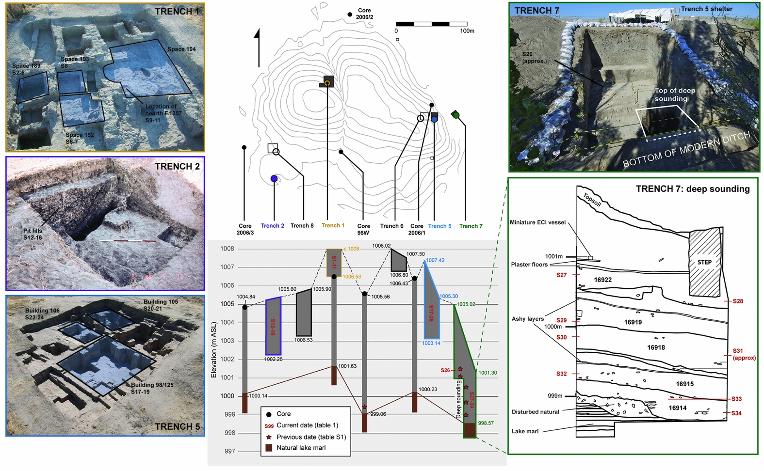
Thirty-three AMS dates on 32 short-life samples (S# from here on) from Çatalhöyük West are presented here, deriving from trenches 1, 2, 5 and 7. These relatively shallow excavations (except for trench 7), represent some of the latest occupation in their respective areas and lack the multiple building levels excavated on the East Mound (Figures 2 & 3). Of 34 samples, 32 produced successful determinations (Tables 1 & S2). Sixteen samples from trenches 1 and 2 were published by Higham et al. (Reference Higham, Bronk Ramsey, Brock, Baker and Ditchfield2007), but are discussed here in context for the first time. Calibration and modelling used OxCal 4.3 (Bronk Ramsey Reference Bronk Ramsey2009) and the IntCal13 calibration curve (Reimer et al. Reference Reimer, Bard, Bayliss, Beck, Blackwell, Bronk Ramsey, Buck, Cheng, Edwards, Friedrich, Grootes, Guilderson, Haflidason, Hajdas, Hatté, Heaton, Hoffmann, Hogg, Hughen, Kaiser, Kromer, Manning, Niu, Reimer, Richards, Scott, Southon, Staff, Turney and van der Plicht2013). Full OxCal code is provided as supplementary information.
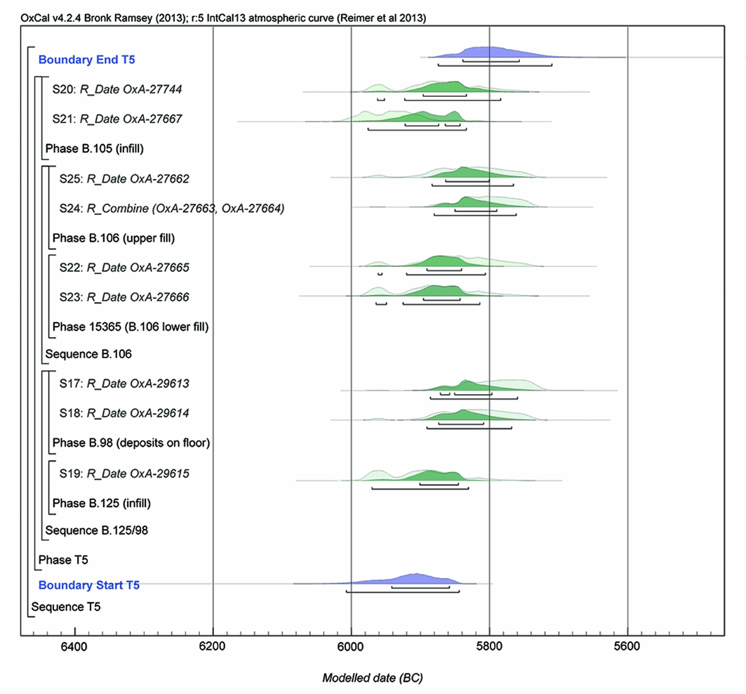
Positions and elevations of interventions at Çatalhöyük West, with details of approximate provenance for dating samples. (Photographs by Jason Quinlan and Peter Biehl. Trench 7 section drawing by Ingmar Franz.)
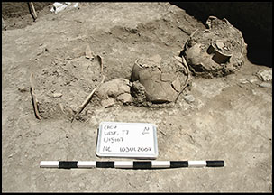
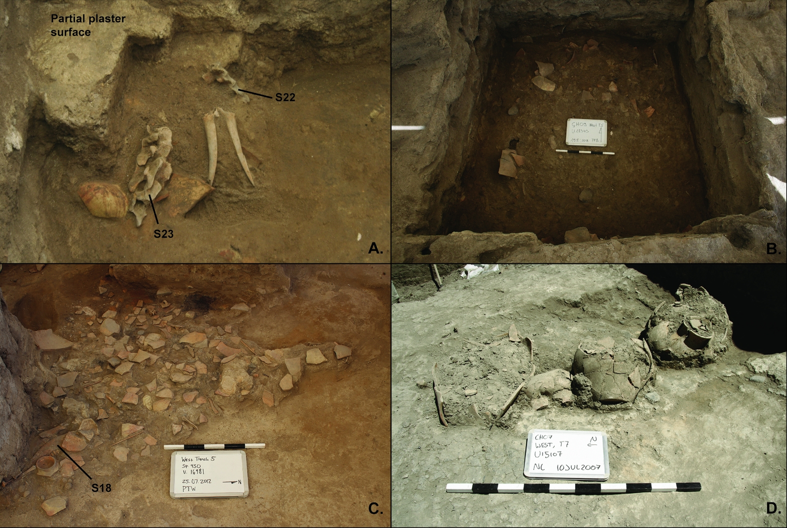
Provenance of selected samples: A) cluster 15365 in building 106 (S22–23); B) fill layer 18343 in building 106 (S24); C) fill layer 16981 on the floor of building 98 (S18); and D) surface 15107 in trench 7 (S26, Poz-24048). (Photographs by Peter Biehl and Patrick Willett.)
New radiocarbon dates from Çatalhöyük West. (See text for calibration details and Table S2 for full contextual information and supporting data.)
Trench 1
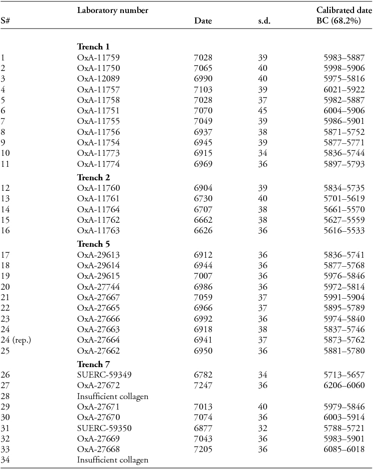
S1–11 are charred cereal grains from building 25 in trench 1, associated with Early Chalcolithic I pottery and adjacent to deposits excavated by Mellaart. A core taken beneath this building indicates a further 4.9m of anthropogenic deposits below the limit of excavation (Gibson et al. Reference Gibson, Hamilton and Last2000).
Treating these as a single phase (Figure 4) gives estimated start and end dates of 6010–5935 BC and 5865–5780 BC respectively at 68.2% (6055–5900 BC and 5890–5720 BC at 95.4%)—confirming that the West Mound was occupied during the first quarter of the seventh millennium BC, possibly as far back as 6000 BC, even before unexcavated underlying deposits are taken into account.
Radiocarbon results from trenches 1–2.
Trench 2
S12–16 are charred cereal grains from two intercutting pits in trench 2, associated with Early Chalcolithic II pottery as noted by Mellaart (Reference Mellaart1965: 136). These span a surprisingly long period (Figure 4), from 5860–5730 to 5600–5485 BC at 68.2% (6025–5665 to 5625–5320 at 95.4%). Nevertheless, through comparison with building 25, these dates can be seen to confirm Mellaart's relative chronology of Early Chalcolithic I and II.
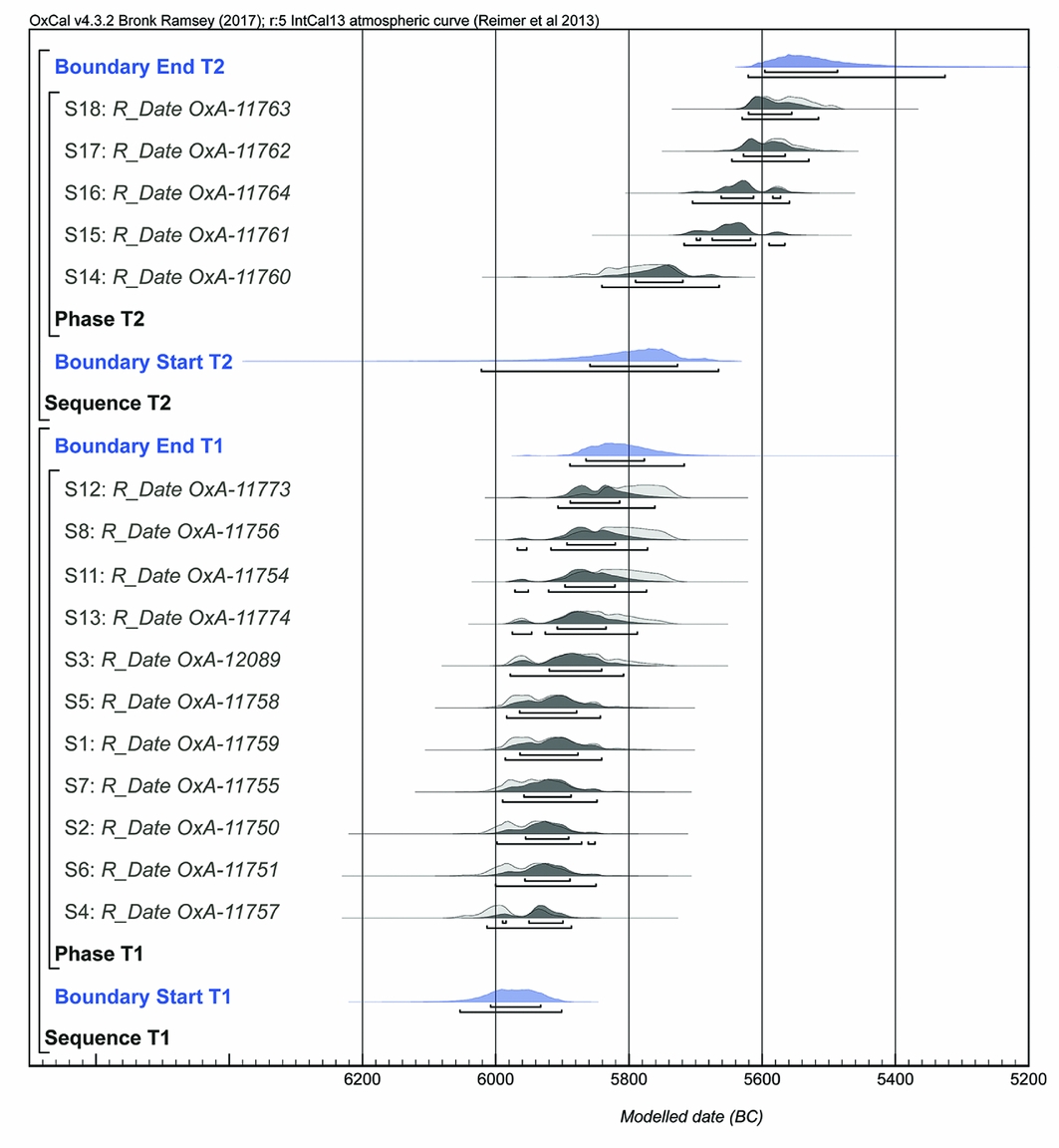
Trench 5
S17–25 derive from three Early Chalcolithic I building/infill sequences in trench 5. Being from in situ articulated bone, these dates are amenable to stratigraphic modelling, albeit limited by shallow stratigraphy and a lack of crosslinks (Figure 5). This gives a tight range with start and end boundaries of 5950–5860 BC and 5840–5760 BC respectively at 68.2% (6010–5845 and 5875–5710 at 95.4%). This suggests that occupation commenced by c. 5900 BC, again not taking into account unexcavated underlying deposits—the deepest sample dated from trench 5, S19, was taken from a level some 3m higher than the lowest anthropogenic deposits recorded in a nearby core (2006/1, see Figure 2).
Radiocarbon results from trench 5.
Trench 7
Trench 7 was cut into the side of a 3.7m-deep modern irrigation ditch at the south-east edge of the mound, with a small ‘deep sounding’ continuing through a further, approximately 2.8m of cultural deposits to natural lake marl. S26 derives from a surface associated with in situ Early Chalcolithic I pots, towards the base of the main trench, while S27–34 are spread through the deep sounding. Only two articulated bone sets were available for dating (S26 & 31), with the other dates taken from disarticulated bone.
Although trench 7 produced five previously published radiocarbon dates (Table S1; Biehl et al. Reference Biehl, Franz, Orton, Ostaptchouck, Rogasch, Rosenstock, Hofmann, Moetz and Müller2012), their chronological order does not fit the stratigraphic sequence. The interface with the natural deposits gave the latest date of 4900–4695 BC at 68.2% (Poz-24051), while the earliest date of 6058–6005 BC at 68.2% (Poz-24048) was obtained from the same surface as S26, stratigraphically above the deep sounding. Residuality alone cannot be responsible for this incongruence. If correct, Poz-24051 would make the entire trench 7 sequence post-sixth millennium BC, including several in situ floors with Early Chalcolithic pots. Contamination is more plausible: all five samples have C:N ratios outside the expected range for collagen of 2.9–3.6 (DeNiro Reference DeNiro1985), with Poz-24051 being particularly high (Figure 6). By contrast, all 16 new dates from trenches 5 and 7 fall within the expected range.
Radiocarbon ages of trench 7 dates against (A) carbon:nitrogen ratio (C:N, grey band shows expected range) and (B) elevation.
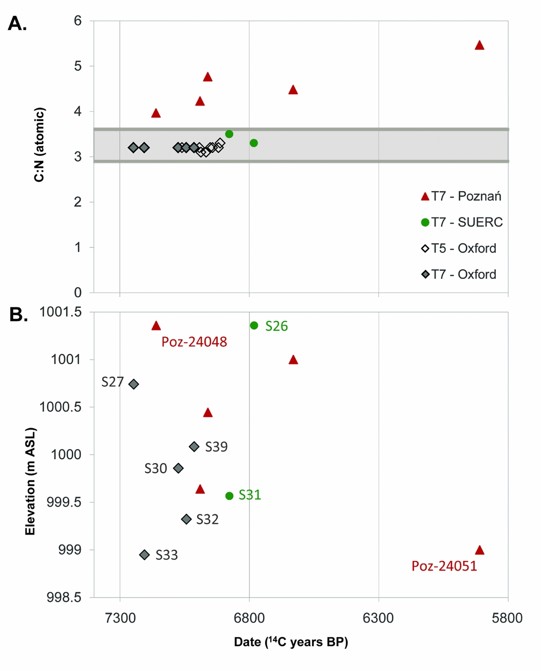
The two articulated bone samples provide reliable anchors. Sample 26 places the end point of the dated sequence at 5715–5660 BC (68.2%), while sample 31, from mid-way through the deep sounding, dates to 5790–5720 BC (Figure 7). The five disarticulated bone samples may be residual, particularly given the tell-edge stratigraphy. This is clear for S27–30, stratigraphically between S26 and 31, but significantly pre-dating both. S32–33 from below S31 may or may not be in their original context.
Radiocarbon results from trench 7.
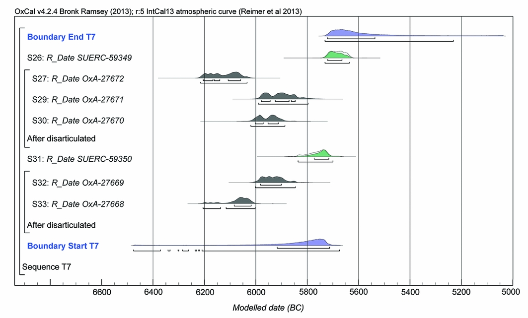
Our model for trench 7 fully includes only the two articulated samples, treating the others as termini post quos (Figure 7) to produce a very uncertain start boundary of 5920–5715 BC (68.2%). All five of the disarticulated samples pre-date 5800 BC, however, with two of five falling in the late seventh millennium BC. These probably represent activity in the broader vicinity, perhaps redeposited through downwash, although we cannot entirely exclude the East Mound as a point of origin.
Overall model
Each dated trench/core was included within an overall bounded phase representing West Mound occupation. Under this model, occupation is estimated to have lasted between 6015–5965 and 5615–5570 BC at 68.2% (6040–5935 and 5625–5530 at 95.4%).
This almost certainly underestimates significantly the antiquity of the mound, considering the metres of unexcavated deposits underlying trenches 1 and 5. Nonetheless, Figure 8 compares start boundaries for our overall West Mound model, and each trench-level model, with the estimated end dates reported for the East Mound, and more specifically for the final domestic structure (building 33) and burial chamber (Sp.248) respectively (Marciniak et al. Reference Marciniak, Barański, Bayliss, Czerniak, Goslar, Southon and Taylor2015: fig. 2).
Estimated end dates for Çatalhöyük East (Marciniak et al. Reference Marciniak, Barański, Bayliss, Czerniak, Goslar, Southon and Taylor2015), and start and end boundary dates for Çatalhöyük West, plus selected un-modelled dates.
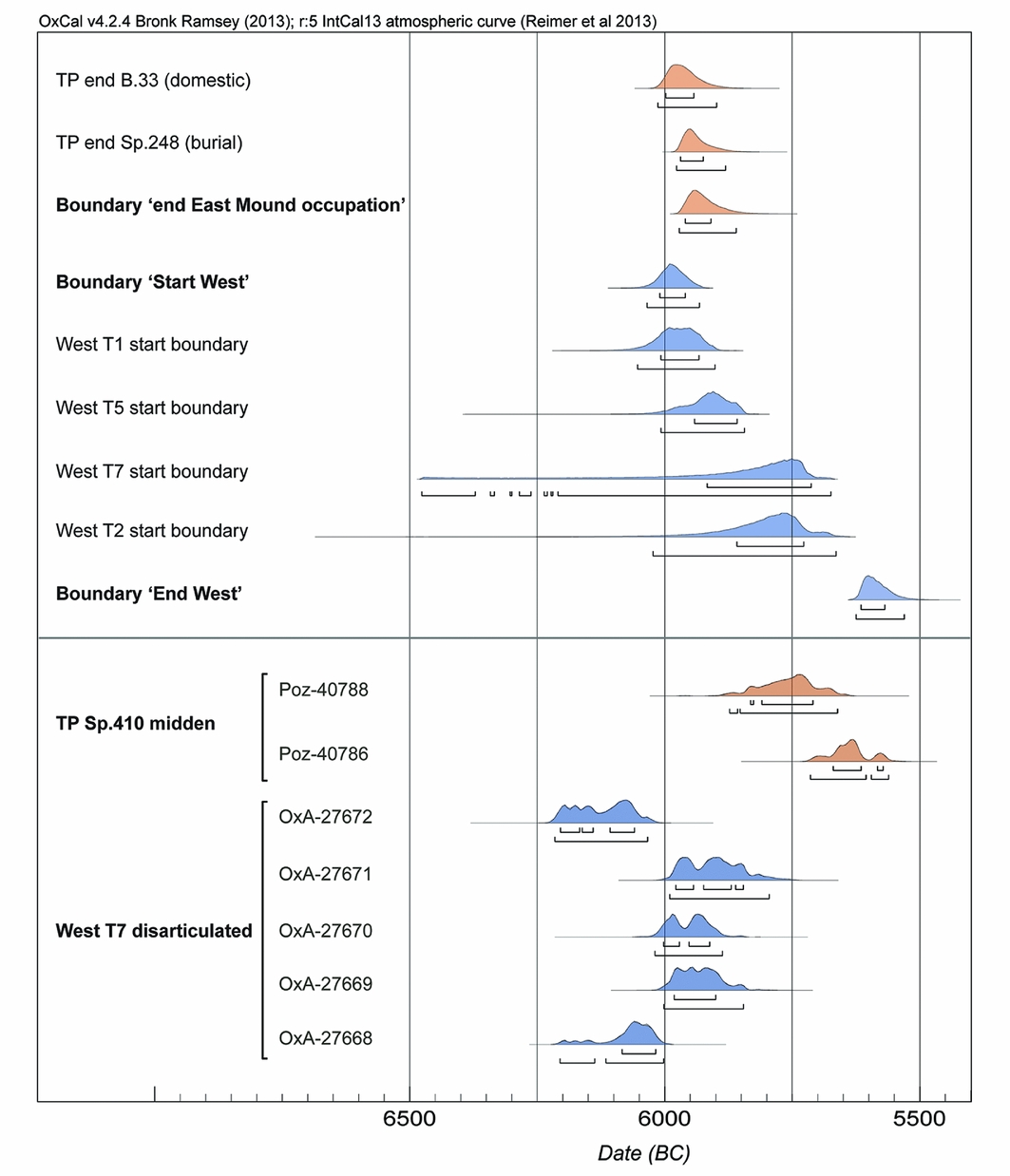
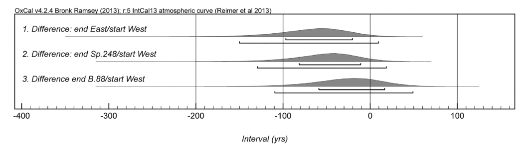
The impression given is of a clear overlap in activity and probable overlap in occupation. This is confirmed by direct comparison between the start boundary for our overall model and the end boundary for Çatalhöyük East, which, even without factoring in the potential age of the unexcavated deposits, gives an overlap in occupation of 20–100 years at 68.2% or between 150 years’ overlap and 10 years’ hiatus at 95.4% (Figure 9).
Intervals between estimated start dates for Çatalhöyük West and end dates for: 1) all East Mound occupations; 2) the last burial chamber in the TP area; and 3) the last domestic structure in the TP area. Negative numbers indicate overlap; positive numbers indicate hiatus. This model does not account for unexcavated deposits.
Discussion
Our results confirm that there was no hiatus between settlement on the two mounds. Dates from trenches 1 and, arguably, 7 demonstrate that Çatalhöyük West was occupied by the first century of the sixth millennium BC, while activity at Çatalhöyük East persisted until at least the middle of the same century (Marciniak et al. Reference Marciniak, Barański, Bayliss, Czerniak, Goslar, Southon and Taylor2015). A strong case can now be made for a significant overlap between the two tells:
1. Based on 11 AMS determinations, deposits in trench 1 associated with building 25 began at 6010–5935 BC (68.2%), matching the estimated end date for building 33, the last-known domestic structure on the East Mound. The 4.9m of anthropogenic deposits beneath building 25 must represent a significant period of prior activity. While the rate of höyük build-up at Çatalhöyük West is unknown and, as with all tells, probably complex and varied, a crude extrapolation from the overall height and duration of the East Mound would give a very rough estimate of approximately 250 years.
2. Coring near trench 5 indicates an additional, approximately 3m of anthropogenic deposits beneath the limit of excavation, again suggesting occupation commenced well before the 5950–5860 BC (68.2%) estimated here—perhaps around 160 years (calculated using the same method as above).
3. Two of the five disarticulated bone samples from trench 7 date to the late seventh millennium BC, while the remainder date to the first two centuries of the sixth millennium BC. Even if all are residual, their most plausible point of origin is from farther up the mound; it is unlikely that both early samples derived from the East Mound.
Taking these points together, we propose a significant period of co-existence between the two tells, although we cannot reliably estimate its duration without excavation down to the natural sediments in a non-peripheral area of the West Mound. A conservative estimate of c. 6100 BC for the start of occupation implies an overlap of up to two centuries.
Traditionally, the two mounds have been seen as discrete settlements with distinct communities. Viewed as a single settlement, with shifting foci of occupation, their co-existence does not require special explanation. Settlement on the East Mound had already shifted over time with the abandonment of the north eminence during the later seventh millennium BC. A gradual transition from East–West Mounds seems a priori more probable than a sudden translocation of the entire community, although it remains unclear why settlement shifted when it did. Explanations linked to changes in river course and/or water regime (Roberts & Rosen Reference Roberts and Rosen2009: 399) may still apply, with some residents moving closer to the water supply, while others chose to remain in the traditional settlement core. Alternatively, or additionally, the expansion might represent social fissioning, linked to the increased household autonomy, competition and mobility posited for the later seventh millennium.
Despite evidence for an Early Chalcolithic population dispersal on the Konya Plain (Baird Reference Baird and Hodder2005: 71), the East–West transition at Çatalhöyük need not have entailed a reduction in population. Although the West Mound's footprint is smaller than that of the East, the latter's population had already declined significantly by the later seventh millennium BC (Hodder Reference Hodder2014: 12). The extent to which this was balanced by expansion to the West Mound depends partly on the as yet unknown chronological relationship between the foundation of the West Mound and the abandonment of the north eminence of the East Mound. We cannot assume that the population of Çatalhöyük West was, at its height, smaller than that of late seventh-millennium Çatalhöyük East.
The early dating of trenches 1 and 5 indicates either that the most visible material changes between Çatalhöyük East and West were rapid, with roots in the later East Mound sequence, or that their development represented a divergence in practices. Dated deposits in trenches 1, 2 and 5 are characterised by abundant painted pottery, pushing this development back to the second, if not the first, century of the sixth millennium BC, while buttressed two-storey buildings are present in trench 5, at least, by c. 5900 BC.
That Çatalhöyük East and West were a single settlement does not preclude some degree of social differentiation between them. Decisions about relocation were probably bound up with status, identity and kinship, and there are also hints of functional differentiation. While burial played a central role in the TP area after c. 6200 BC, no prehistoric adult burials are yet known from the West Mound. Interments in burial chambers on the East Mound probably continued for “a few decades” (Marciniak et al. Reference Marciniak, Barański, Bayliss, Czerniak, Goslar, Southon and Taylor2015: 154) after the cessation of settlement activity, with the implication that those interred—and those who interred them—were residents of Çatalhöyük West. This may equally apply to some earlier burials. As the focus of occupation shifted to the West Mound, burial, and perhaps other ritual activities, may have remained tied to the traditional settlement core. On the other hand, domestic activity also persisted on the East Mound, almost until its final abandonment. Indeed, two midden dates indicate sporadic activity even after this point (Marciniak et al. Reference Marciniak, Barański, Bayliss, Czerniak, Goslar, Southon and Taylor2015: 173). The burial places of Çatalhöyük residents after c. 5900 BC remain unknown.
Despite significant, rapid change in material culture, there was no sudden disjuncture in settlement at Çatalhöyük, no radical break in the sequence and no need to invoke models entailing external disruption. Instead, reasons for the move may lie in internal processes, with roots in a mid seventh-millennium BC shift in social organisation (Hodder Reference Hodder2014). Environmental stimuli, cultural contacts and population movements might have contributed to these processes, and a gradual settlement shift starting in the late seventh millennium actually accommodates models involving the 8200 BP climate event better than would a sudden move around 6000 BC (Clare Reference Clare2016; cf. Flohr et al. Reference Flohr, Fleitmann, Matthews, Matthews and Black2016: 35). Nonetheless, suggestions that climate change caused an abrupt temporary abandonment of the settlement are no longer tenable.
Conclusions
The East and West Mounds at Çatalhöyük had an appreciable overlap in occupation around 6000 BC, although the exact duration remains undetermined. They should thus be seen as parts of a single settlement, with a gradual shift probably beginning within the latter quarter of the seventh millennium BC, and persisting until the first century of the sixth. While the reasons for this shift remain debatable, its gradual nature has two key implications for models of change at Çatalhöyük, and in Central Anatolia more widely.
First, it calls into question the idea that the total population at Çatalhöyük declined rapidly through the later seventh millennium and into the sixth, in association with settlement dispersal on the Konya Plain and beyond. While the East Mound population certainly declined after c. 6500 BC, it remains to be seen from what point, and to what extent, this was offset by settlement at Çatalhöyük West. Second, it militates strongly against arguments for a radical disruption to settlement, whether caused by climatic change or population movements. The rate of social change at Çatalhöyük, as in Anatolia more widely, was rapid in the later seventh and early sixth millennia BC, but the continuity between the two mounds suggests that this story is primarily one of fast-paced internal evolution. Ultimately, our findings present a cautionary tale regarding the assumption that prehistoric settlements are coterminous with their visible manifestations, particularly in the form of tells.
Acknowledgements
We thank the Çatalhöyük Research Project; the Ministry of Culture and Tourism of the Republic of Turkey; the University at Buffalo; Freie Universität Berlin; the Alexander von Humboldt Foundation; the University of Cambridge; the British Academy; several private donors; and numerous colleagues who have contributed to West Mound excavations. We are very grateful to Craig Cessford, who undertook the dating for trenches 1 and 2, funded by NERC. Particular thanks also go to Chris Doherty, Camilla Mazzucato and Alex Bayliss. Dates from trenches 5 and 7 were funded by the NERC Radiocarbon Facility (NF/2012/2/10; AB/DO) and the University of York. Useful comments on drafts were provided by Clive Orton, Tom Higham and Penny Bickle.
Supplementary material
To view supplementary material for this article, please visit https://doi.org/10.15184/aqy.2018.91


 Open access