




Introduction
The Second World War arguably produced more documentary evidence than any other major historical conflict (Moshenska Reference Moshenska2013), with military files, maps, films, photographs, reports and testimonies preserved in many countries and languages. Furthermore, over the past 75 years, the war has been subject to academic scrutiny, as well as the subject of diverse narratives and cultures of memory (Evans & Lunn Reference Evans and Lunn1997; Dawson et al. Reference Dawson, Roper and Ashplant2000; Jarausch & Lindenberger Reference Jarausch and Lindenberger2007). To date, the scholarly literature is dominated by approaches that rely on historiographical methods (Rass & Lohmeier Reference Rass and Lohmeier2011). Most historical narratives are often disconnected from the physical location and projected onto imagined spaces (Carman & Carman Reference Carman and Carman2006), resulting in the blurring of the spatial dimension of history and its locality. On a micro level, a full understanding of specific military events is difficult to achieve if written and documentary sources are considered in isolation from the material evidence of such battles. Indeed, most aspects of past warfare cannot be thoroughly assessed without due consideration of their archaeological and geoarchaeological traces.
State of research, aims and research questions
The detection, documentation and interpretation of sub-surface material traces of violent events must be conducted using a rigorous protocol, with established, interdisciplinary methodologies integrating archaeology, geoarchaeology, geophysics, history and cultural studies. This pushes conflict archaeology well beyond the role it is often ascribed of simply documenting the physical setting or stage for textually documented events. The challenges facing a study of conflict landscapes from the Second World War are thus twofold: firstly, what constitutes an appropriate set of methods through which to detect, document and interpret (geo)archaeological evidence of modern warfare? And secondly, how might the integrated analysis of such archaeological data with documentary sources change our perceptions of military events and the material dimension of twentieth-century battlefields?
Within the context of the Second World War, archaeology has most often been applied to high-profile battlefields (e.g. Passmore & Harrison Reference Passmore and Harrison2008; Moshenska Reference Moshenska2013; Barone & Groen Reference Barone and Groen2018). Archaeology is an important method for tracing and recovering human remains from battlefields, and has also been employed in the recovery and analysis of specific objects, such as planes, ships and logistical structures (e.g. Passmore et al. Reference Passmore, Tunwell and Harrison2013; McCartney Reference McCartney2014; McKinnon & Carrell Reference McKinnon and Carrell2015). Recently, non-invasive approaches have been deployed more extensively in relation to twentieth-century sites of violence (e.g. Björkdahl & Buckley-Zistel Reference Björkdahl and Buckley-Zistel2016; van der Schriek & Beex Reference van der Schriek and Beex2017; Stichelbaut et al. Reference Stichelbaut, Note, Bourgeois, van Meirvenne, van Eetvelde, van Den Berghe and Gheyle2018). Following the successful use of such methods at the sites of former concentration camps (Hausmair & Bollacher Reference Hausmair and Bollacher2019), and sites of mass murder from the Second World War (Sturdy Colls Reference Sturdy Colls2012), it is now time to update, systematise and adjust the methodology for documenting mid twentieth-century warfare and violence. This will allow us to gather as much data as possible from beneath the surface without the need for destructive excavation.
This article contributes to the development of this methodology, and, in doing so, advances from three principal starting points. Even with regard to recent and well-documented historical events, the use of non-invasive methods can:
1) Enable the linking of events and places on the micro level.
2) Improve our understanding of the spatial dimension of war.
3) Contribute reliable new data previously unrecorded in other documentary sources, and reveal events with only limited or no conventional documentation.
We test these three points using an innovative interdisciplinary set of methods and a specific case study of the clash between U.S. Army and Wehrmacht units on Germany's western border in late 1944—the Hürtgen Forest battlefield (Rass et al. Reference Rass, Lohmeier and Rohrkamp2009; Rass & Lohmeier Reference Rass and Lohmeier2011; Saunders Reference Saunders2011; Cowley & Stichelbaut Reference Cowley and Stichelbaut2013; Rost & Wilbers-Rost Reference Rost and Wilbers-Rost2013; Bussmann et al. Reference Bussmann, Stele, Härtling, Zielhofer and Fuchs2014; Passmore et al. Reference Passmore, Harrison and Tunwell2014; Stichelbaut & Cowley Reference Stichelbaut and Cowley2016).
In recent years, conflict archaeology and conflict-landscape studies of the twentieth century have refined our understanding of the material transformation and discursive translation (i.e. how people talk about and remember) of sites of violence (Carman & Carman Reference Carman and Carman2006), enabling the development of more thematic and methodological perspectives. Such research began with the archaeological documentation of fixed structural evidence on First World War battlefield sites (Saunders Reference Saunders2011), before moving on to semi-permanently imprinted structures of positional warfare (Fraser & Brown Reference Fraser and Brown2013) based on historical documents and maps, aerial photography and lidar mapping (Opitz & Cowley Reference Opitz and Cowley2013). These approaches have enhanced our understanding of changes in the materiality of battlefields during active combat and of post-battle processes (Rass & Lohmeier Reference Rass and Lohmeier2011; Saey et al. Reference Saey, Stichelbaut, Bourgeois, van Eetvelde and van Meirvenne2013; Stichelbaut et al. Reference Stichelbaut, Gheyle, van Eetvelde, van Meirvenne, Saey, Note, van Den Berghe and Bourgeois2017; van den Berghe et al. Reference van den Berghe, Gheyle, Note, Stichelbaut, van Meirvenne, Bourgeois and van Eetvelde2018).
The shift in research focus from the fixed positional warfare typical of the First World War to the study of the more mobile conflict of the Second World War has necessitated a corresponding methodological adjustment. In departing from a focus on structural remains such as the ‘Westwall’ (the German defensive line opposite the French Maginot Line) (Groß et al. Reference Groß, Rohde, Rolf and Wegener1997), the main challenge became the detection, documentation and interpretation of semi-permanent features sometimes faintly visible on the surface, but usually only detectable below ground (e.g. Rass & Lohmeier Reference Rass and Lohmeier2011; Passmore et al. Reference Passmore, Harrison and Tunwell2014; Capps Tunwell et al. Reference Capps Tunwell, Passmore and Harrison2016). To this end, in addition to conventional documentary sources and archaeological excavation, non-invasive methods have also been increasingly used, such as geogenic and cultural heritage (Blum Reference Blum2005; Bund/Länder-Arbeitsgemeinschaft Bodenschutz 2011). Digital geoarchaeology (Siart et al. Reference Siart, Forbriger, Bubenzer, Siart, Forbriger and Bubenzer2018a & Reference Siart, Forbriger and Bubenzerb) and innovations in near-surface geophysics (Linford et al. Reference Linford, Persico and Piro2019), for example, have opened up new perspectives. Not only do these approaches lead to a broader understanding of archaeological landscapes, but also to a new scale of exploration, prospection and GIS-driven spatial analysis of the materiality of war (Nolan Reference Nolan2013; Siart et al. Reference Siart, Forbriger, Bubenzer, Siart, Forbriger and Bubenzer2018a).
Although geoarchaeological approaches to the Second World War in Western Europe have previously been conducted (e.g. Gaffney et al. Reference Gaffney, Gater, Saunders and Adcock2004; Everett et al. Reference Everett, Pierce, Save, Warden, Dickson, Burt and Bradford2006; Ainsworth et al. Reference Ainsworth, Pringle, Doyle, Stringfellow, Roberts and Stimpson2019), they have yet to be tested on the semi-permanent battlefields from the final stages of the war. Geoarchaeology and geophysics can never be employed to confirm specific historical narratives, but it must be allowed to challenge any account based on a different category of evidence. In turn, this allows us to understand better the relationship between material and documentary evidence, and to deconstruct narrative or discursive layers and the layers of material evidence. This requires a set of methods for the systematic detection, documentation and interpretation of war-related evidence and the integrated analysis of both documentary historical evidence and material cultural processes. Such methods allow for a diachronic analysis, even on battlefields exposed to mobile warfare (Baberowski Reference Baberowski2012) and which have seen profound post-event transformations (Rass & Lohmeier Reference Rass and Lohmeier2011).
Approach
Our approach aims at a process-oriented understanding of the genesis and transformation of conflict landscapes on material and discursive levels. It therefore combines methods ranging across the humanities and the natural sciences (Figure 1; Interdisziplinäre Arbeitsgruppe Konfliktlandschaften 2019). This allows us to gather different types of data from a given battlefield in its present state, and to then proceed to clarify the various stages of its transformation, gradually moving back towards the event horizon (Rass & Lohmeier Reference Rass and Lohmeier2011).
Methodological approach of the University of Osnabrück interdisciplinary working group on conflict landscapes (figure by the authors).

We classify the battlefields into three types: type one is characterised by structural remnants, such as fortifications or bunkers; type two bears visible traces of violence or related military activities on the surface, but no permanent structures; type three shows no obvious signs of violent events on the surface. Often, these features occur in combination on larger sites, and may not appear as clearly defined as in the classification presented above. Our aim is to build simplified models of such sites based on documentary sources and geoscientific data (Interdisziplinäre Arbeitsgruppe Konfliktlandschaften 2019). These can then be used to understand better the physical locations, and also to plan targeted excavations, with a minimal destructive effect. Here, we test this proposed combination of methods using a case study to demonstrate its potential.
Research area, historical background and fieldwork
The village of Vossenack in the northern Eifel region, to the south-east of Aachen in western Germany, represents the centre of the study area. It was one of the most important sites during the battle in the Hürtgen Forest (Schlacht im Hürtgenwald), which took place between September 1944 and February 1945 (Atkinson Reference Atkinson2015). American and German military units fought an intense ground war in the north Eifel region, in the western borderlands of the German Reich. Between 2 and 8 November 1944, fighting was concentrated around Vossenack (Rush Reference Rush2001; Atkinson Reference Atkinson2015; Zimmerli Reference Zimmerli2016) when the 28th Infantry Division of the U.S. Army attacked the villages of Vossenack, Kommerscheidt and Schmidt. The primary objective was to capture the village of Schmidt to gain access to the southern part of the Rur River valley (Figure 2).
Location map of the Vossenack Ridge (raw data DLM 50 of North Rhine-Westphalia (Land NRW 2020); figure by the authors).

On the morning of 2 November 1944, three companies of the 28th Infantry Division advanced towards Vossenack, which, by that same evening, was captured and occupied. Command posts were set up in several buildings, as well as manned defensive positions—so-called ‘foxholes’—in a perimeter around the enemy-facing parts of the village. Light machine gun (LMG) positions formed part of this defensive perimeter on the village flanks, as well as on its eastern edge (also known as Vossenack Ridge). It seems thus far, in established narratives based mainly on the publication of MacDonald and Mathews (Reference Macdonald and Mathews1952) and on the stories of local people, that these unit positions were falsely located and in need of further investigation.
The battlefield around Vossenack can be classified as a composite of both types two and three conflict landscapes, in that there are surface marks of the battle in woodland and in areas of non-agricultural open ground. For the most part, however, surface traces were removed after 1945, either by ordnance clearing, land restoration, agriculture or the building of new infrastructure. The location of U.S. Army fighting positions can therefore no longer be identified by survey of open ground today. Our research team has conducted five fieldwork seasons on the battlefield since 2014: three large-scale surface prospections comprising extensive magnetic surveys and two archaeological excavations on Vossenack Ridge. We have also reviewed relevant U.S. Army files in the National Archive and Records Administration, as well as several sets of historical aerial reconnaissance photographs, most of which are available through the National Collection of Aerial Photography in Scotland (https://ncap.org.uk). All historical documentary and geoscientific data have been georeferenced in a GIS database to facilitate the interdisciplinary analysis.
Deconstructing the historical narrative
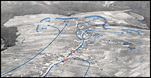
An aerial reconnaissance photograph published by American military historians Charles B. MacDonald and Sidney T. Mathews (Reference Macdonald and Mathews1952) forms the basis of a widely known narrative that places U.S. Army fighting positions on Vossenack Ridge, close to the eastern edge of the village. The annotated aerial photograph was first published in 1952 and marked with the note “All positions and movements approximate” (Figure 3; MacDonald & Mathews Reference Macdonald and Mathews1952: map VIII). Historiography of the battle still leans on MacDonald and Mathews's description, anchoring the central focus of the military action with a set of landmarks on the battlefield, such as the church of Vossenack (Landkreis Monschau 1970; Westdeutscher Rundfunk n.d). For years, the activities of groups of both looters and re-enactors have corroborated this interpretation, as all of the artefacts they have recovered have been interpreted in light of the annotated photograph. Their activities have also left physical traces, such as ‘fake’ foxholes, reconstructed field positions, destroyed earthworks and filled-in digs, which have left a new layer of material evidence in the landscape (Saunders Reference Saunders2002: 101–102; Saunders et al. Reference Saunders, Faulkner, Košir, Črešnar and Thomas2013). Upon reviewing the U.S. Army files and conducting preliminary field surveys, we aimed to challenge the established narrative and begin to understand the layered landscape of Vossenack Ridge.
Approximation of the 112th Infantry Regiment positions on the eastern edge of Vossenack (MacDonald & Mathews Reference Macdonald and Mathews1952: map VIII).

Methodological triangulation
Historical evidence
U.S. Army records from the 28th Infantry Division provide spatial information on the location of soldiers and units in map overlays, as well as through geographic coordinates recorded in reports and combat diaries. These localisations occur periodically in the documentation and can be used to construct a spatio-temporal model of army movements and positions. These records, however, lack consistency and are often unclear. Here, these historical data are considered as a single record of the events, while archaeological data gathered from the field are considered as separate but equal sources.
Our research question centres on an attempt to locate the actual U.S. Army fighting positions on Vossenack Ridge, using LMG positions as indicators for the location of the American lines between 2 and 6 November 1944. Indeed, several map overlays produced by the 112th Infantry Regiment of the 28th Infantry Division locate both the 2nd Battalion and LMG positions at different sites compared to both historiographical and local narratives (National Archive and Records Administration n.d.). The available disposition overlays (Figure 4) place a substantial question mark over central tenets of the consensus battle narrative.
Disposition overlay of the 2nd Battalion, 112th Infantry Regiment on 4 November 1944 (National Archive and Records Administration, file RG407, photograph by C. Rass).

Due to the distorted perspective of the aerial photograph cited by MacDonald and Mathews (Reference Macdonald and Mathews1952: map VIII), we georeferenced the indicated positions along with all available disposition overlays in the GIS database. Figure 5 shows the proximity of MacDonald and Mathews's annotations to the edge of the village, along with the disposition of U.S. troops according to the overlays produced by the 112th Infantry Regiment in November 1944. These georeferenced representations (in blue) indicate a larger distance between the U.S. positions and the eastern edge of the village, and show a deviation from the location given by MacDonald and Mathews, which is marked in red (Figure 5). The maximum distance is around 190m. While MacDonald and Mathews placed the U.S. Army right on the crest of the Vossenack Ridge, the disposition overlays mark American foxholes on the forward slope, facing the enemy out in the open. This leaves us with a historical narrative tied to two different sites.
Vectorised disposition overlay (in blue; compare with Figure 4) and approximations from MacDonald and Mathews (Reference Macdonald and Mathews1952) (in red; compare with Figure 3), over the georeferenced aerial photograph of 16 November 1944, over a lidar local relief model (generated and visualised in planlauf/TERRAIN (planlauf GmbH 2019) using the digital terrain model data of North Rhine-Westphalia (Land NRW 2019)) (figure by the authors).

Although MacDonald and Mathews provide no specific information on the American line, other than their position on the crest of the ridge, the disposition overlays indicate several machine gun positions, abbreviated L for light machine gun (Figure 4). These mark strategic points of the American defensive positions and serve as targets for investigation. A validation of their actual location could serve as proof that the disposition overlays provide a more precise record than the annotated photograph provided by MacDonald and Mathews (Reference Macdonald and Mathews1952: map VIII). An assumption that the disposition overlays are correct would change the relationship between the historical narrative and the actual site significantly.
Remote-sensing sources
The corpus of historical aerial reconnaissance photographs available for Vossenack between September 1944 and February 1945 provides no conclusive evidence for the American positions on Vossenack Ridge during the first week of November 1944. Despite numerous overflights—even during active fighting—there is not a single aerial photograph showing the area in question during the battle. Although an image taken on 16 November 1944 does cover the area of interest (Figure 5), traces of foxholes or LMG positions cannot be identified on the heavily shelled and partly snow-covered landscape. As a next step, we used lidar to create a digital terrain model to visualise structural surface remains, even in wooded areas. For research on open ground, as in this case, however, the digital terrain model/lidar data are of limited value, as agricultural use has erased all surface remains. Hence, in this example, lidar data are used only for the draping of georeferenced historical photographs and maps onto the digital terrain model, in order to add a third dimension to enhance interpretation (Figure 5).
Geophysical prospection
After choosing those locations—determined from the overlay to be strategic vantage points—a survey of the site was carried out, beginning with high-resolution and non-invasive fluxgate magnetometry (Bartington & Chapman Reference Bartington and Chapman2003) (Figures 5–6 & 7b). The technique is able to cover large areas quickly, detecting magnetic anomalies that predominantly correspond with anthropogenic activities (Stele et al. Reference Stele, Fassbinder, Härtling, Bussmann, Schmidt and Zielhofer2019) in the shallow sub-surface. These magnetic anomalies can be further investigated using magnetic susceptibility (Dearing et al. Reference Dearing, Dann, Hay, Lees, Loveland, Maher and O'Grady1996; Dearing Reference Dearing1999; Stele et al. Reference Stele, Fassbinder, Härtling, Bussmann, Schmidt and Zielhofer2019).
Vectorised disposition overlay (in blue; only the defensive perimeters and light machine gun positions (blue circles) of the Companies F and G are shown) over the results of magnetometry surveys, and over a lidar local relief model (generated and visualised in planlauf/TERRAIN (planlauf GmbH 2019) using the digital terrain model data of North Rhine-Westphalia (Land NRW 2019)) on Vossenack Ridge. Magnetometry was undertaken using a Bartington Grad 601dual (spatial resolution 0.50 × 0.25m, interpolated to 0.25 × 0.25m) (figure by the authors).
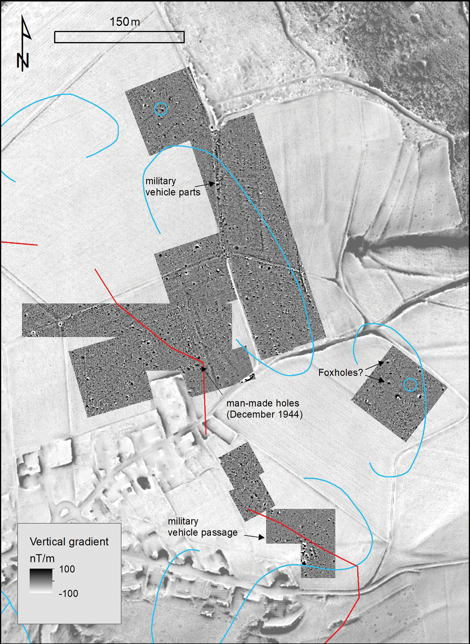
a) Vectorised disposition overlay (blue) over the georeferenced aerial photograph of 16 November 1944 (National Collection of Aerial Photography n.d) within the magnetogram grid (yellow); b) magnetogram of the area examined. Magnetometry was undertaken using a Bartington Grad 601dual (spatial resolution 0.50 × 0.25m, interpolated to 0.25 × 0.25m) (figure by the authors).

Since 2014, we have surveyed an area of approximately 7ha to the east of Vossenack using magnetic prospection, including both of the given locations of the U.S. positions. The survey has revealed numerous dipolar anomalies, indicating shrapnel, cartridges and vehicle parts, as well as linear anomalies indicating the tracks of military vehicles, and anthropogenic holes (see magnetograms with anomaly examples in Figure 6). The data reveal the spatial correlation between the LMG position of G Company and the disposition overlay. The LMG position associated with F Company on the overlay in the south-eastern part of Vossenack Ridge, however, does not correlate precisely with any anomaly (Figure 6). Divergences between the marked positions and magnetic anomalies can be traced back to inaccurate drawing on the battlefield.
Any interpretation relating to past events must consider the coexistence of material and alterations that post-date the historical event(s). It is therefore essential to verify any conclusions via ground-truthing. On Vossenack Ridge, the LMG position marked as part of the line of foxholes in the disposition overlay (Figure 4) was georeferenced and linked to historical aerial photographs, as well as to the magnetogram. The latter (shown in Figure 7b) covers an area of 80 × 80m and shows several distinct anomalies, the largest of which—in the middle of the magnetogram—shows an exact magnetic field vector alignment with the negative part in the north and intensities between 15 and 40nT. In archaeological contexts, such thermoremanent properties are attributed to highly (in situ) heated sub-surface deposits (Fassbinder Reference Fassbinder2015). Aligning the magnetogram with the georeferenced disposition overlay using GIS reveals that the thermoremanent anomaly correlates to the drawn point, indicating the LMG position (compare Figures 7a–b). To validate this correlation, ground-truthing was undertaken via a combination of metal-detector prospection and archaeological excavation.
Archaeology
Metal-detector prospection of a rectangular, 4425m2 area around the thermoremanent anomaly yielded 312 finds from the ploughed topsoil. These finds include irregularly distributed fragments of artillery and mortar shells, along with fired cartridge casings and unfired .30 calibre (7.62mm) U.S. Army cartridges and a few small pieces of infantry equipment. These results encouraged further investigation of the thermoremanent anomaly by archaeological excavation. For this purpose, the coordinates of the core area of the anomaly were measured using GIS and staked out using the Global Navigation Satellite System.
An archaeological excavation team from the Landschaftsverband Rheinland was consulted to excavate the site. Removal of the plough soil (Figure 8: layer 1) revealed the outline of a 0.70 × 1m oval feature. The depth of the feature was 0.70m below the surface, and it had two fills (Figure 8: f1 & f2). Although the features’ fills had the same grain-size composition as the surrounding natural soil, leading to the initial conclusion that the fills must be in situ geological deposits, the fills were anthropogenically mixed, heterogeneous in colour (Munsell Color 2010) and rich in humus (comparable to the topsoil). The eastern part of the feature (Figure 8: f2) was reddish-brown in colour—clearly the result of intense heat exposure (Scheffer et al. Reference Scheffer, Schachtschabel and Blume2002; Roberts Reference Roberts2015). The high magnetic susceptibility parameters of this area compared with the surrounding soil indicate that this location represents the thermoremanent anomaly in the magnetogram (Figure 8; Dearing et al. Reference Dearing, Dann, Hay, Lees, Loveland, Maher and O'Grady1996; Dearing Reference Dearing1999). Both fills of the feature were also interspersed with charred wood remains and metal parts with traces of burning. Furthermore, additional unfired projectiles and cartridge casings of .30 (7.62mm) calibre were recovered from the fills of the feature. We assume that these are the remains of a burnt ammunition box, which contained unfired projectiles and cartridges. The shallowness of the feature was probably due to repeated ploughing in the decades after the battle.
Above) photograph of the archaeological finding with the identification of the strata; below) the respective characteristic values (Munsell Color 2010) and magnetic susceptibility parameters for the identified strata (photograph by M. Schwickert, figure below by the authors).

Discussion and conclusions
The combination of methods chosen for this case study has allowed us to locate a possible U.S. Army LMG position and ammunition fire in an area of the battlefield in the Hürtgen Forest, where no traces of the events of November 1944 are visible on the surface. We used as our starting point two different sets of evidence, each of which provide different locations for U.S. positions on the Vossenack Ridge. The combination of historical aerial photographs and documents, map overlays, lidar data, magnetometry, metal-detecting and archaeological excavation—all integrated within a GIS database—has allowed us to conclude that the U.S. positions as indicated in the original map overlays, which are contradicted or ignored in current historiographical accounts, are most likely correct.
This research contributes significantly to the understanding of the events on the Vossenack Ridge. U.S. positions were not dug on the crest of the ridge, but were far down the slope, and thus exposed to the weather and to German mortar and artillery fire from the opposite side of the valley. Their large distance from the shelter provided by the village houses gave them little chance of withstanding a counterattack by German infantry on the morning of 6 November 1944. This interpretation has strong evidential support in that G Company's LMG position was identified not only in documents and the corresponding magnetogram, but also through the discovery of spent and unspent ammunition used by a U.S. Browning M1919A4 LMG. Furthermore, the archaeological evidence matches the size and shape of a possible foxhole. Remains of burnt material within the thermoremanent feature, as well as the reddish-brown staining, clearly result from intense heat exposure probably associated with an ammunition fire.
The precision with which we were able to pinpoint features with non-invasive techniques (in this case magnetometry), and to investigate them with carefully targeted excavation, has revealed unparalleled insight into the transformation of the landscape during and after the battle. These results suggest the necessity of further research in order to refine such an approach for application to other situational contexts on modern battlefields. This would maximise our knowledge of both visible and invisible traces of violence without disturbing either the soil or the archaeology. In the future, we plan to refine these non-invasive prospection techniques, and the triangulation of magnetometry with other geophysical methods, such as ground-penetrating radar and electrical resistivity.
In summary, our study at Vossenack Ridge shows that U.S. infantry units were in a completely different location than previously assumed, and in a much weaker position than they would have been at the edge of the village. Out in the open, U.S. infantrymen were exposed to more intense machine-gun, mortar and artillery fire. This evidence prompts us to reassess the course of the battle of Vossenack Ridge during early November 1944.
More generally, we suggest that modern battlefield archaeology and conflict landscape studies can benefit from a multi-perspective approach, in which the natural sciences and the humanities interact with, and test each other. Our example has shown that combining historical, geophysical, geoarchaeological and archaeological approaches has the potential to challenge established narratives. It is therefore worthwhile to use such approaches to verify well-documented events of recent and past periods.
Acknowledgements
The authors thank Petra Tutlies and the Amt für Bodendenkmalpflege im Rheinland of the Landschaftsverband Rheinland, who carried out the archaeological excavations. We have further benefitted from exchange and discussion with members of the Arbeitsgemeinschaft Luftkriegsgeschichte Rhein/Mosel, who also participated in the metal-detector prospection of the site, and from archival sources provided to us in cooperation with Ian Spurgeon of the Defense POW/MIA Accounting Agency (DPAA) in Washington, D.C. Finally, we thank the two anonymous reviewers for their very constructive reviews and valuable advice.
Funding statement
The authors wish to express their gratitude to the Konejung-Stiftung: Kultur and Achim Konejung, who generously funded our fieldwork at Vossenack through a grant and provided indispensable expertise and knowledge on the historical background.


 Open access

