


INTRODUCTION
The mode and timing of the earliest hominin dispersals in Europe have been one of the most debated topics during the last decades in paleoanthropology (for a review, see Manzi [2016]). Nonetheless, a consensus has been reached about the presence of human populations scattered in southern regions of the continent since the Early Pleistocene, including even rare occupations of more northern latitudes (Carbonell et al., Reference Carbonell, Bermúdez de Castro, Parés, Pérez-González, Cuenca-Bescós, Ollé and Mosquera2008; Arzarello et al., Reference Arzarello, Marcolini, Pavia, Pavia, Petronio, Petrucci, Rook and Sardella2009; Despriée et al., Reference Despriée, Moncel, Arzarello, Courcimault, Voinchet, Bahain and Falguères2018). It is probable that these earliest colonization stages were sporadic (e.g., Agustí et al., Reference Agustí, Blain, Cuenca-Bescós and Bailon2009), influenced by environmental and climatic conditions that were particularly important during the 1.4–0.4 Ma interval.
The time span bracketed between the late Early and the early Middle Pleistocene was characterized by a considerable change in the Earth's climate and has been defined as the Mid-Pleistocene Transition or Revolution (Maasch, Reference Maasch1988; Saltzman and Maasch, Reference Saltzman and Maasch1988; Maslin and Ridgwell, Reference Maslin, Ridgwell, Head and Gibbard2005; O'Regan et al., Reference O'Regan, Bishop, Lamb, Elton, Turner, Head and Gibbard2005), now also referred to as the Early-Middle Pleistocene Transition (EMPT; Ruddiman et al., Reference Ruddiman, Raymo and McIntyre1986; Poirier and Billups, Reference Poirier and Billups2014; Head and Gibbard, Reference Head and Gibbard2015). Particularly, a significant ecological reorganization occurred during Marine Oxygen Isotope Stage (MIS) 16, around 700 ka (e.g., Manzi et al., Reference Manzi, Magri and Palombo2011). The recurring Homo dispersals may be regarded, therefore, as a component of the faunal renewal that arose during the late Early Pleistocene and at the onset of the Middle Pleistocene, when large mammals of ultimate African and Asian origin spread in Western Europe (e.g., Moncel et al., Reference Moncel, Despriée, Voinchet, Tissoux, Moreno, Bahain, Courcimault and Falguères2013, Reference Moncel, Ashton, Lamotte, Tuffreau, Cliquet and Despriée2015; Palombo, Reference Palombo2014).
Fluctuations in global climate and the resulting ecological changes were probably one of the main constraints also for the subsequent hominin evolution in Europe, involving the relevant Paleolithic assemblages (McNabb, Reference McNabb, Head and Gibbard2005; Moncel et al., Reference Moncel, Ashton, Lamotte, Tuffreau, Cliquet and Despriée2015). Nevertheless, the exact relationship between the possible dispersal in Eurasia of hominins referred to Homo heidelbergensis (Rightmire, Reference Rightmire2008; Mounier et al., Reference Mounier, Marchal and Condemi2009, Reference Mounier, Condemi and Manzi2011; Stringer Reference Stringer2012; Manzi, Reference Manzi2016) and the onset of bifacial or “Acheulean” technology remains questioned (Moncel et al., Reference Moncel, Despriée, Voinchet, Tissoux, Moreno, Bahain, Courcimault and Falguères2013).
The transition between MIS 12 and MIS 11 (the Mid-Brunhes event, according to some authors; Masson-Delmotte et al., Reference Masson-Delmotte, Stenni, Pol, Braconnot, Cattani, Falourd and Kageyama2010; Lang and Wolff, Reference Lang and Wolff2011; McClymont et al., Reference McClymont, Sosdian, Rosell-Melé and Rosenthal2013) represented another substantial change in climate dynamics that coincided with the end of the EMPT. Starting from this period, the archaeological record shows increased occupation, new subsistence behaviours, technical innovations (i.e., core technologies and increase of light-duty tools), and regionalization, coupled with increased social interactions (Moncel et al., Reference Moncel, Ashton, Lamotte, Tuffreau, Cliquet and Despriée2015, Reference Moncel and Schreve2016; Peretto et al., Reference Peretto, Arzarello, Bahain, Boulbes, Dolo, Douville and Falguères2016).
A fossil specimen of special interest for this scenario is the human calvarium found in 1994 by one of us (I. Biddittu) in the area known as Campogrande, near the town of Ceprano, central Italy (Fig. 1). The site is close to the area of Colle Avarone, where archaeological and paleontological research started in the early 1970s, with the finding of a rich Acheulean assemblage (Biddittu, Reference Biddittu1974). From a morphological point of view (Manzi et al., Reference Manzi, Mallegni and Ascenzi2001; Mounier et al., Reference Mounier, Condemi and Manzi2011; Manzi, Reference Manzi2012, Reference Manzi2016; Di Vincenzo et al., Reference Di Vincenzo, Profico, Bernardini, Cerroni, Dreossi, Schlager and Zaio2017), the Ceprano calvarium may be considered as an archaic variant of the species Homo heidelbergensis, which evolved in both Africa and Eurasia during the Middle Pleistocene (Rightmire, Reference Rightmire1998, Reference Rightmire2008; Hublin, Reference Hublin2009; Stringer, Reference Stringer2012). It represents a reliable proxy for the original morphology of this taxon, penecontemporaneous with more derived phenotypes that were already diversifying in Africa and Eurasia.
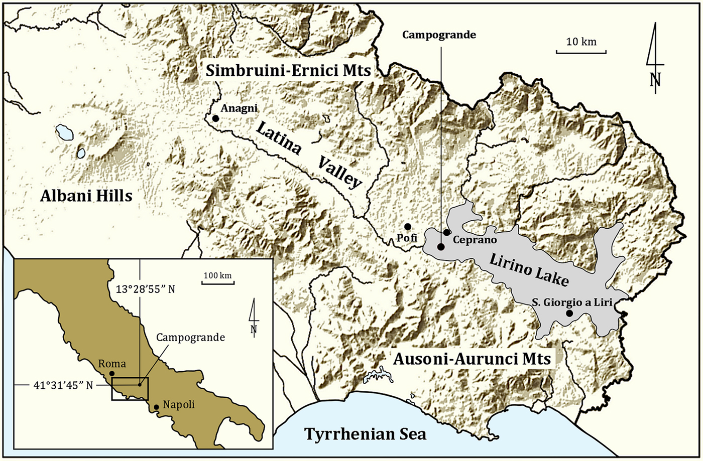
(color online) Location of the Campogrande area near Ceprano in the Italian peninsula and, particularly, in southern Latium, approximately midway between Rome and Naples, along the Latina Valley (Sacco river). The gray area corresponds to the inferred maximum extension of the Lirino Lake during the Middle Pleistocene.
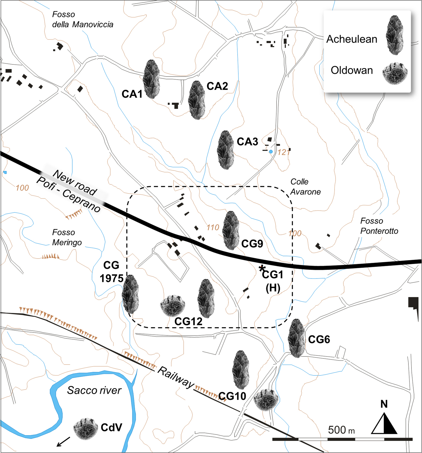
Since its discovery, surface surveys in the area led to the mapping of twelve localities with archaeological and/or paleontological assemblages (Fig. 2), named progressively from Campogrande (CG) 1 to 12, each sometimes including more than one archaeological unit, as reported in Table 1. Subsequently, fieldwork was carried out between 2001 and 2006 in the area between CG1 and CG9 where the human calvarium was unearthed, aimed at collecting sedimentological data.
(color online) Topographic map of the main archaeological localities referred to the Colle Avarone (CA), Campogrande (CG), and Castro dei Volsci (CdV) areas; the symbols referred to as “Acheulean” and “Oldowan” correspond to assemblages with or without bifaces, respectively. The discovery site of the human fossil calvarium is labelled CG1 (H). The squared dashed line corresponds to the map of Figure 3a.
GPS coordinates and elevation above sea level (m asl) of the selected localities/sites or archaeological units at Campogrande that are mentioned in the text.

In this paper, combining new data with a reappraisal of previous studies in the area (Muttoni et al., Reference Muttoni, Scardia, Kent, Swisher and Manzi2009; Manzi et al., Reference Manzi, Magri, Milli, Palombo, Margari, Celiberti and Barbieri2010; Nomade et al., Reference Nomade, Muttoni, Guillou, Robin and Scardia2011; Margari et al., Reference Margari, Roucoux, Magri, Manzi and Tzedakis2018; Pereira et al., Reference Pereira, Nomade, Moncel, Voinchet, Bahain, Biddittu and Falguères2018), we provide a comprehensive stratigraphy and sedimentology of the uppermost fluvio-palustrine deposits of Campogrande, including those where the human calvarium was discovered. In addition, we describe for the first time the archaeological lithic material found in the overlying fluvial deposits of the localities labelled CG9 and CG10, furnishing further constrains to ascribe the human presence at Campogrande to a period spanning around MIS 11.
GEOLOGICAL AND PALEOENVIRONMENTAL SETTING
The Campogrande area (Fig. 1) is about 3 km southeast of the town of Ceprano (Latium, central Italy). It is in the Latina Valley, a sector of the Apennines that constitutes a graben that was formed in the Middle-Late Pliocene. During the Early and Middle Pleistocene this graben hosted a lacustrine basin (Devoto, Reference Devoto1965; Carrara et al., Reference Carrara, Frezzotti, Giraudi and Carrara1995; Galadini and Messina, Reference Galadini and Messina2004; Centamore et al., Reference Centamore, Di Manna and Rossi2007), which extended for about 35 km in a northwest-southeast direction: the Lirino Lake. Campogrande occupies the northern sector of this basin (Fig. 1), where a primarily terrigenous sedimentation associated with volcaniclastic deposits derived from the Albani Hills volcanic complex and probably also from the Monts Ernici volcanoes (Civetta et al., Reference Civetta, Innocenti, Lirer, Manetti, Munno, Peccerillo, Poli and Serri1979, Reference Civetta, Innocenti, Manetti, Peccerillo and Poli1981) occurred. The Lirino Lake succession has been recently subdivided into two main stratigraphic units bounded by erosional surfaces: LR1 below and LR2 above (Centamore and Dramis, Reference Centamore and Dramis2010; Manzi et al., Reference Manzi, Magri, Milli, Palombo, Margari, Celiberti and Barbieri2010).
The LR1 unit has a thickness spanning between 60 and 130 m and is mainly formed by lacustrine deposits. The basal portion of this unit is constituted of a lime mud with interbedded tephra layers and occupies the depocentre of the lake. The sedimentological character of the carbonate mud indicate deposition caused by microbiological activity in a sector far from the shoreline, as indicated by a pelagic fauna that is mainly represented by cold temperature molluscs, ostracods and diatoms (Devoto, Reference Devoto1965). The middle and upper portions of LR1 are characterized by lime sands and muds with rare volcanic material, replaced towards the lake margin by silty-mud and sands, showing intercalations of thin carbonate levels formed by Chara and scanty cemented gravel lenses with discontinuous volcanic layers. The proximity of the lake margins is confirmed by the inclined depositional profile and by the occurrence of small slumps with abundant shallow water fauna, such as gastropods and ostracods (Devoto, Reference Devoto1965). The tephra layers in the basal portion of LR1 have been dated to 583–570 ± 11 ka and are related to the activity of the Roccamonfina volcano (Chiesa et al., Reference Chiesa, Floris, Gillot, Prosperi, Vezzoli and Carrara1995; Narcisi, Reference Narcisi and Carrara1995).
The LR2 unit was deposited during the maturity and the filling phase of the Lirino Lake and shows a facies variability connected to the coexistence of fluvial and lacustrine-swamp environments in which volcaniclastic layers were frequently deposited (Devoto, Reference Devoto1965; Centamore and Dramis, Reference Centamore and Dramis2010). Along the northern margin of the basin, LR2 is characterized by carbonate sand and mud with travertine deposits; on the southern margin, sands and fluvial mud with intercalations of volcaniclastic layers also occur. The malacofauna consists of several terricolous taxa living in shallow waters rich in limnetic plants, indicating a temperate climate (Devoto, Reference Devoto1965). The ostracoda assemblage is quite different from that of LR1, especially for the occurrence of crenophilous species, adapted to oligo- and mesohaline environments. This fossil assemblage indicates spring pools characterized by high concentration of Ca and Mg, as also testified by travertine intercalation in the carbonate mud that also suggest the proximity of the lake shore (Devoto, Reference Devoto1965). The tephra layers on the upper part of LR2 are most probably derived from the Roccamonfina volcano, record the final infilling of the Lirino Lake and have been dated to 359 ± 7 and 354 ± 7 ka (Narcisi, Reference Narcisi and Carrara1995).
Starting from this period, the succeeding Middle-Upper Pleistocene and Holocene deposits are represented by terraced gravels and sandy-gravel alluvial sediments, with intercalated volcanoclastic layers, often deformed and tilted by northwest-southeast- and northeast-southwest-oriented faults that were related to the Apennine postorogenetic extensional tectonics. The latter activities have produced substantial morphostructural changes in the examined area, including the tectonically tilted deposit recorded in our trench T (Fig. 3, 5), the variations in the drainage pattern, the erosion of the oldest deposits, the fragmentation of the Latin paleovalley, and the tectonic depression that hosted the Lirino Lake (Centamore and Dramis, Reference Centamore, Di Manna and Rossi2007).
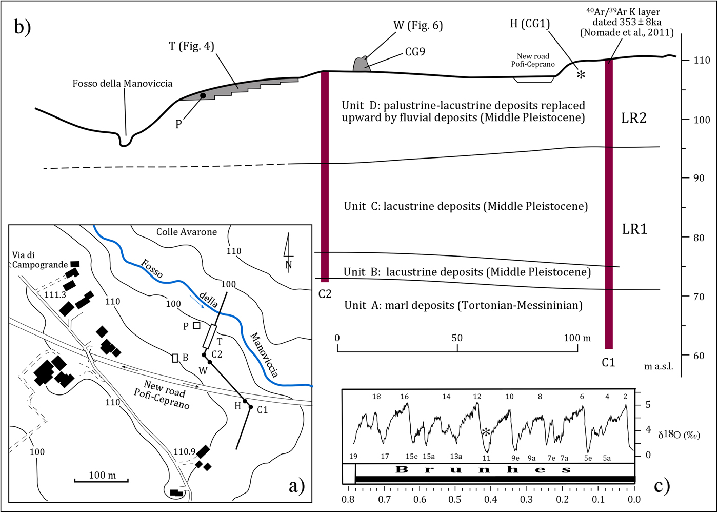
(color online) (a) Partial view of the area of Campogrande, which includes: the discovery site of the human fossil specimen and the various excavations and drillings performed in period 2001–2006. Some of them are also reported in (b) the correlation panel extending in a north-south direction and showing the stratigraphic relationships among the different units that have been recorded. The black ball in (b) indicates the projected stratigraphic position of the Palaeoloxodon antiquus (P) within the deposits of trench (T), corresponding to the clay layer in Figure 5 between units 10 and 11. (c) The marine oxygen isotope record from Lisiecki and Raymo (2005), with the inferred chronological position of the Ceprano human calvarium based on lithostratigraphical, geochemical, palynological, and geochronological data (Manzi et al., Reference Manzi, Magri, Milli, Palombo, Margari, Celiberti and Barbieri2010). B, excavation test in the locality CG9; C1/C2, Core 1 and Core 2; H, site of discovery of the human calvarium (CG1); P, excavation, site of discovery of a partial skeleton of Palaeoloxodon antiquus; T, trench along the slope towards the Fosso della Manoviccia; W, stratigraphic witness above the present ground level (extension of locality CG9).
MATERIAL AND METHODS
With the aim of refining the paleoenvironmental context of the area where the Ceprano calvarium was unearthed, the trenches and other excavations in the locality labelled CG9 (B, P, T, and W in Fig. 3a and b; see also Table 1) are described here according to classical sedimentological methods, integrated with data coming from two drilled cores (C1 and C2 in Fig. 3a and b; see also Table 1). Grain size and other textural attributes are reported, including sedimentary structure and color. Other features, such as the presence of shelly debris, clasts of clay, organic matter, wood fragments and roots, are also taken into consideration for the paleoenvironmental interpretation.
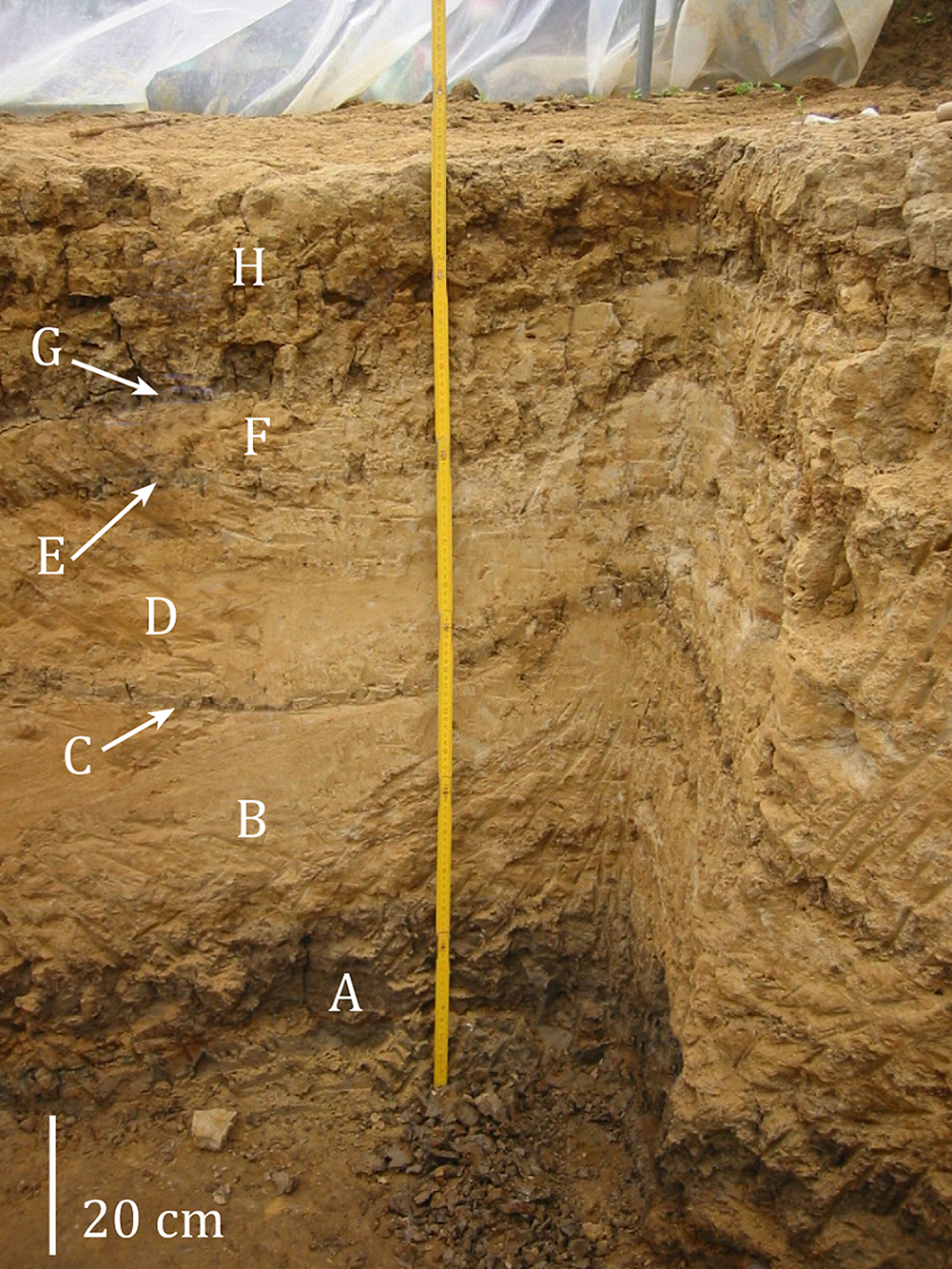
In order to understand the compositional characters of these deposits, nine samples were collected from trenches in the P and T sites for analysis of clay mineralogy (see Supplementary Material for the X-ray diffractometry diagrams of the samples). In the section P (Fig. 4), three samples of clays were taken: two (samples 1 and 2) from the clays at the bottom of the section (unit A), where the skull of Palaeoloxodon antiquus was found, while the third sample (sample 3) was taken in the clays at the top of the section (unit G). It is relevant that these last clays belong to the same stratigraphic interval where the human calvarium was discovered, as evidenced by the correlation between the C1 and C2 cores (Muttoni et al., Reference Muttoni, Scardia, Kent, Swisher and Manzi2009; Manzi et al., Reference Manzi, Magri, Milli, Palombo, Margari, Celiberti and Barbieri2010). In the trench T (Fig. 5), six samples were taken in the units 10 (samples 4 and 7), 7 (samples 12 and 13), 4 (sample 23), 3 (sample 24), and 1 (sample 26), respectively. Analyses of the clay samples were conducted using bulk X-ray diffractometry. The identification of the mineralogical phases was made by comparing the Miller indices found in the samples with those of the International Centre for Diffraction Data.
(color online) The stratigraphic sections of site P during excavation; letters only indicate the different mud and silty-sand horizons alternating along the section. The samples for clay composition derive from units A and H.
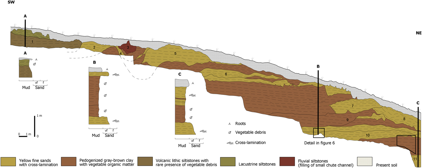
(color online) Stratigraphic section of the trench T (see Figures 3a and b). Units 3 and 4 are clay plug deposits; unit 1 is the palustrine deposits with high concentration of volcanic ash. The square at the level of section B refers to Figure 6, while the polygon on the right marks the stratigraphic horizon that corresponds to the clay deposits of site P. Samples for clay composition derive from units 1, 3, 4, 7, and 10.
For the archaeological material, our aim was to identify the reduction processes performed in each site (Geneste, Reference Geneste1991; Texier and Roche, Reference Texier, Roche, Bermúdez de Castro, Arsuaga and Carbonell1995), through the succession of gestures and technical choices for the manufacturing and the techno-economic process, in order to describe associated cognitive skills. Cores allowed the identification of knapping methods by the observation of the hierarchy of flaking surfaces and the analysis of removal sequences (Despriée et al., Reference Despriée, Moncel, Arzarello, Courcimault, Voinchet, Bahain and Falguères2018). For the heavy-duty component, we identified the volumetric processes, sizes and morphological results (Goren-Inbar and Sharon, Reference Goren-Inbar and Sharon2006; Key et al., Reference Key, Proffitt, Stefani and Lycett2016; Herzlinger et al., Reference Herzlinger, Wynn and Goren-Inbar2017).
RESULTS
Drilled cores C1 and C2
The two cores that were drilled in 2005 are 48 m (C1) and 36 m (C2) long (Fig. 3), respectively. C1 was a few meters from locality CG1 (or “H” in Fig. 2 and 3), where the human calvarium was discovered; C2 was drilled 50 m northwest from C1, in the area of locality CG9. A normal geomagnetic polarity was recorded in both cores and has been interpreted as pertaining to the Brunhes chron (Muttoni et al., Reference Muttoni, Scardia, Kent, Swisher and Manzi2009). Although an overview of their composition was already reported by Manzi and colleagues (Reference Manzi, Magri, Milli, Palombo, Margari, Celiberti and Barbieri2010), here we describe the sedimentological succession of the two cores in combination with newly available evidence and focusing on the uppermost layers.
Both cores have a similar stratigraphy with four main units, named from the oldest to the youngest: A, B, C, and D. The lowermost unit A (about 9 m thick) is composed of marl deposits and may be tentatively ascribed to the Tortonian-Messinian (Centamore and Dramis, Reference Centamore and Dramis2010), while the B and C units are attributed to LR1, and the unit D to LR2 (Fig. 3). An unconformity surface separates unit A from the overlying unit B (about 5 m thick), which is composed of a limestone breccia, suggesting deposition in a subaerial setting. The absence of volcanic materials suggests deposition before the beginning of the regional volcanic activity dated about 700 ka (Fornaseri, Reference Fornaseri1985). Unit C is composed of lacustrine sediments and is separated from the underlying unit B by an unconformity surface. It is about 20 m thick and shows a transgressive-regressive trend, characterized by coarse and very-coarse carbonate sands (about 4 m thick) at the base, passing upward to muddy and sandy-muddy deposits (about 10 m thick), with interbedded thin layers of bioclastic material and a high concentration of organic matter. These features suggest a deposition of this unit in shallow water, close to the lake shoreline in a probable deltaic setting.
In the lower and upper portion of this unit, pollen assemblages suggest the continuous presence of a closed-canopy forest that requires temperate climatic conditions associated with interglacial periods. By contrast, the middle portion indicates an interval of increased aridity and lower temperatures that should correspond to a glacial period (Margari et al., Reference Margari, Roucoux, Magri, Manzi and Tzedakis2018). Another discontinuity surface, detected at 14.7 m below the top of the core, separates the unit C from unit D. The sediments of unit D are those in which the calvarium was discovered and are sterile from a palynological point of view (Margari et al., Reference Margari, Roucoux, Magri, Manzi and Tzedakis2018); they indicate a muddy-sand deposition in palustrine-lacustrine shallow water, upward replaced by fluvial deposits whose sedimentological characters are visible in the trench T of locality CG9. Moreover, in the fluvial deposits of unit D a partial skeleton of Palaeoloxodon antiquus was found in the excavation P (Fig. 3a).
The fluvial deposits at the top of C2 contain a leucitic tephra layer, originally K-Ar dated to 385 ± 20 ka (Ascenzi and Segre, Reference Ascenzi and Segre1997a, Reference Ascenzi and Segre1997b), corresponding to the layer in C1 more recently 40Ar/39Ar dated to 353 ± 4 ka (Nomade et al., Reference Nomade, Muttoni, Guillou, Robin and Scardia2011). A remnant of this tephra layer occurs 30 cm above the clay layer where the calvarium was discovered and 1.0–1.2 m below the top of the core C1. Its compositional character suggested to Nomade and colleagues (Reference Nomade, Muttoni, Guillou, Robin and Scardia2011) a relationship with the volcanic activity of the Pofi field (from 410 to 354 ka; Frezzotti et al., Reference Frezzotti, De Astis, Dallai and Ghezzo2007; Boari et al., Reference Boari, Tommasini, Maurenzi and Conticielli2009), an edifice occurring in the middle Latin Valley, just a few kilometres from Ceprano. The tephra layer is clearly visible in the outcropping section W (Fig. 3), where it appears to be truncated by an erosional surface, above which sandy-gravel deposits attributed to a braided fluvial system occur. These gravels and sands include an Acheulean assemblage that has been found in excavations of the stratigraphic witness W and test B (Fig. 3 and 6), both corresponding to the archaeological unit CG9A.
As for the age of the Ceprano calvarium, it has been suggested a chronology bracketed between 430 and 385 ka (MIS 11; Manzi et al., Reference Manzi, Magri, Milli, Palombo, Margari, Celiberti and Barbieri2010), in contrast to the original hypothesis of about 800–900 ka (Ascenzi et al., Reference Ascenzi, Biddittu, Cassoli, Segre and Segre Naldini1996, Reference Ascenzi, Mallegni, Manzi, Segre and Segre Naldini2000). The chronology of the calvarium pointed out by Manzi and colleagues (Reference Manzi, Magri, Milli, Palombo, Margari, Celiberti and Barbieri2010) was obtained through a multidisciplinary approach, which included stratigraphic-sedimentological analysis, palynological data, geochemistry, soil-micromorphology, taphonomy, and the archaeological evidence (see also Di Vincenzo et al., Reference Di Vincenzo, Profico, Bernardini, Cerroni, Dreossi, Schlager and Zaio2017; Margari et al., Reference Margari, Roucoux, Magri, Manzi and Tzedakis2018). The date bracketed between 430 and 385 ka is also consistent with the normal geomagnetic polarity recorded in the area (Muttoni et al., Reference Muttoni, Scardia, Kent, Swisher and Manzi2009) and with the age of 353 ± 4 ka (±1σ full external errors), obtained by Nomade and colleagues (Reference Nomade, Muttoni, Guillou, Robin and Scardia2011; see also Pereira et al., Reference Pereira, Nomade, Moncel, Voinchet, Bahain, Biddittu and Falguères2018) by sampling the coarse-grained volcanoclastic layer above the clay containing the human specimen. Moreover, the clay layer where the calvarium was found is stratigraphically below the Acheulian levels occurring in the same area, namely in the localities CG9 and CG10 (Ascenzi et al., Reference Ascenzi, Biddittu, Cassoli, Segre and Segre Naldini1996, Reference Ascenzi, Mallegni, Manzi, Segre and Segre Naldini2000; Manzi et al., Reference Manzi, Mallegni and Ascenzi2001, Reference Manzi, Magri, Milli, Palombo, Margari, Celiberti and Barbieri2010).
Another important aspect to be considered is the position occupied by the deposits of CG1 in the final filling phase of the Lirino Lake. Such phase is incompatible with a glacial period that would produce a sharp fall of fluvial base level, associated in turn with erosion. Conversely, there is no evidence of erosion at CG1, while we observe the conditions for the formation of accommodation space that was utilized by the lacustrine systems to aggrade and prograde, filling the basin. Coherent with these observations, data from the palynological analysis of samples from core C1 (Margari et al., Reference Margari, Roucoux, Magri, Manzi and Tzedakis2018) suggest two different forest periods, separated by an interval of herb-dominated vegetation, which are both assigned to MIS 13 (interglacial phase). The erosional surface separating the unit C from unit D in the same core is attributed to MIS 12 (glacial phase), pointing out that the timing of deposition of the human calvarium in unit D is within MIS 11, as already hypothesized by Manzi and colleagues (Reference Manzi, Magri, Milli, Palombo, Margari, Celiberti and Barbieri2010).
We argue that the human calvarium was deposited during the period in which the Lirino Lake was definitively filled and when a change in depositional systems occurred, transitioning to a typical fluvial regime, as we describe below. This scenario is more consistent with an age close to 400 ka (i.e., MIS 11), instead of 350 ka (i.e., MIS 10).
Description of the trenches P, T, and B/W
The excavation P (Fig. 3a and 4) occurs in the area where a partial skeleton of Palaeoloxodon antiquus was found. This section is about 20 m northwest from the trench T. The P section is 120 cm thick and characterized by clays at the bottom (unit A; Fig. 4) passing upward to alternating thin beds of ripple cross-laminated sands (units B, D, F, and H in Fig. 4) and mud (units C, E, and G in Fig. 4), which indicate transport of sediments as bed load and suspended load respectively. Both these kinds of deposit show a partial process of pedogenesis with a paleosol profile characterized by a grayish brown clayey Bk horizon, mostly composed of expandable smectite clay, carbonate gray nodules, reduction zones, drab halos, and redoximorphic features (mottles; Calcic Vertisol; FAO, 2006). Rare bioclastic material, represented by fragments of pulmonata gastropoda occur in the clay layers. The set of these characters indicates that the entire sequence of sediments developed in an interglacial stage, with a climate characterized by marked seasonality in rainfall followed by dry conditions; this, in turn, is consistent with the assignments to MIS 11of the clay where the calvarium was found.
The trench T (Fig. 3, 5, 6), about 3 m deep, is oriented N40E and the whole deposit is tectonically tilted up to southwest. A stratigraphic panel of the trench (Fig. 5) indicates several depositional units with a clear fining-upward trend, which are bounded above and below by inclined erosional surfaces. In particular, these units (from 11 to 3) are comprised in the lower portion by yellow fine and very fine-grained sands, showing planar and trough cross-lamination (Fig. 6), passing upward to pedogenized brown muddy deposits which are very rich in organic matter (Calcic Vertisol; FAO, 2006). Genesis of sand cross-lamination is related to the migration of bedforms as ripples and small dunes, with lee-side laminae dipping towards the south-southeast (N150E). The higher portion of the trench (southwest sector) is characterized by muddy deposits (units 1 and 2), with rare plant fragments and a high percentage of volcaniclastic detritus forming a clay plug.
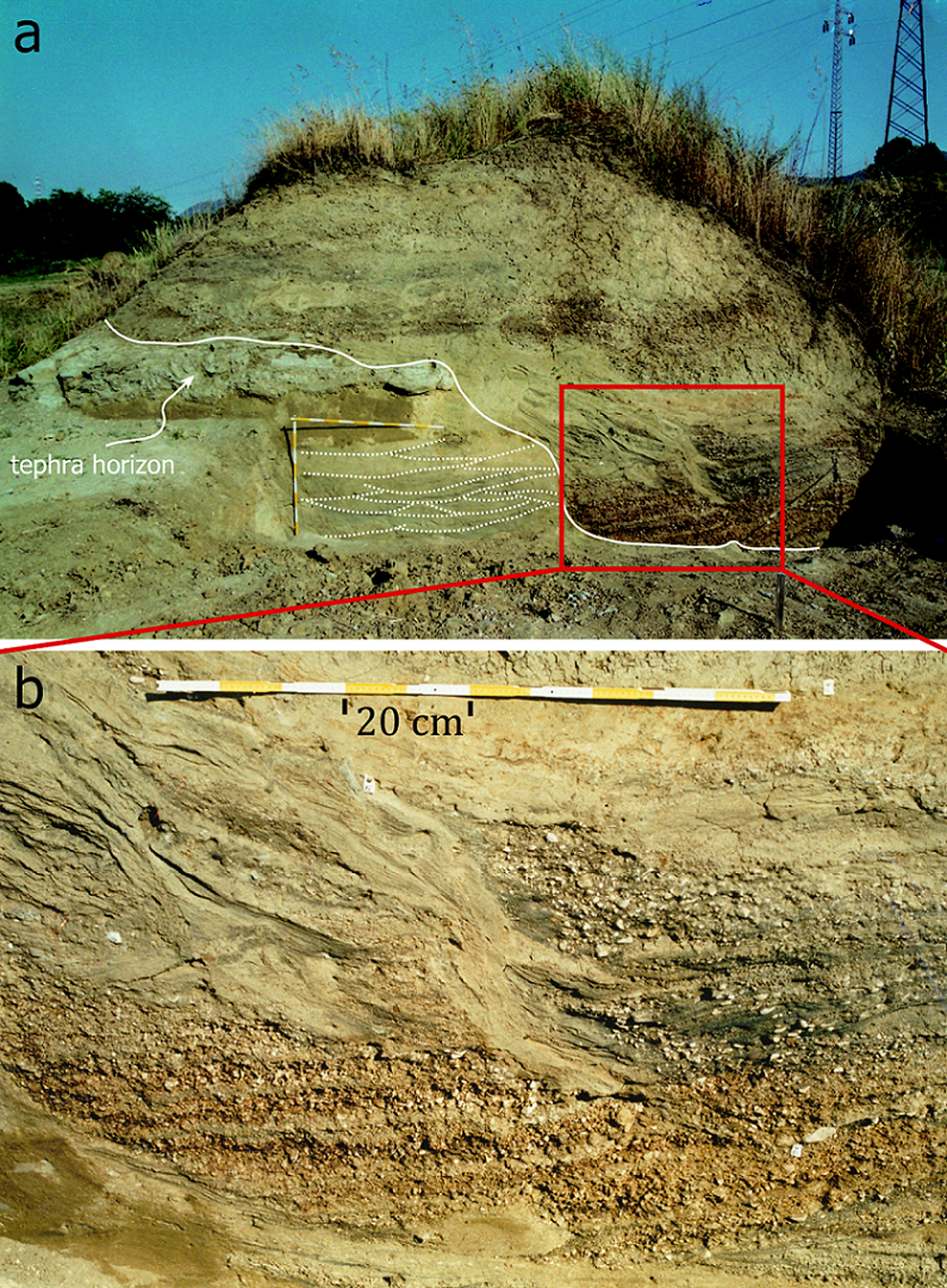
(color online) Detail of the section B in the trench T (as indicated in Figure 5), showing small and medium trough cross-lamination occurring at the base of the meandering fluvial channel.

From a stratigraphic point of view and based on the correlation among the measured sections and the cores C1 and C2, the deposits of the P section are equivalent to the deposits of unit 11 of trench T (Fig. 5). The comparison between the clay mineralogical samples (see Supplementary Material) indicates that those in P correspond to the clay interval of the unit 11 of the trench T. They show a high percentage of clay minerals, essentially chlorite and montmorillonite, illite, and kaolinite, and a low percentage of quartz. The presence of montmorillonite stratified with illite and chlorite and the absence of sialic phases suggests strong leaching for a long time produced this clay unit. Moreover, the presence of the chlorite could suggest an alteration process of basic volcanic rocks rather than acid rocks. Calcite and feldspathoids are absent. On the contrary, the younger samples taken from other depositional units (units 10, 7, 4, 3, and 1; Fig. 5) show that quartz is the most abundant mineral followed by plagioclase, calcite, and clay minerals like montmorillonite, illite, chlorite, and kaolinite. Such an assemblage suggests a different origin of these minerals, probably from the erosion and the alteration of carbonate rocks, as well as terrigenous siliciclastic sedimentary rocks. A possible change in the drainage area of the fluvial system can be hypothesized in order to explain this variation in mineral composition. This could have been caused by tectonic activity. As a result, the change from unit 11 and the following ones (from unit 10 to 1) should represent a discontinuity surface connected with the final filling of the Lirino Lake. During this last phase, the volcaniclastic layer was deposited; either it is referred to an eruptive phase of the Roccamonfina volcano (Ascenzi and Segre, Reference Ascenzi and Segre1997a, Reference Ascenzi and Segre1997b) or to the Pofi volcano (Nomade et al., Reference Nomade, Muttoni, Guillou, Robin and Scardia2011; Pereira et al., Reference Pereira, Nomade, Moncel, Voinchet, Bahain, Biddittu and Falguères2018).
Although of limited thickness and extent, the deposits of trench B and witness W (Fig. 3 and 7) is composed of sandy gravel and gravelly sand, which are placed above the tephra layer clearly visible in the outcropping section W (Fig. 7). These layers form terraced alluvial deposits corresponding to the Colfelice Synthem in the new Italian geological map at 1:50,000 scale (Sheet 402, Ceccano; Centamore and Dramis, Reference Centamore, Di Manna and Rossi2007). On the basis of the outcrops occurring in surrounding areas (including the localities CG9 and CG10), these deposits show a tabular geometry and are internally characterized by sheets of structureless or flat-bedded imbricated gravels, associated with medium-scale trough or planar cross-bedding sandy gravels, which form lenticular or tabular sets (10 to 50 cm thick). Such deposits are organized to constitute depositional units (from 50 to 100 cm thick), exhibiting a fining-upward trend. Finer-grained sediments (essentially silt) are poorly or not preserved, suggesting therefore high-energy flows responsible for the deposition of sand and gravels. Locally, ripple cross-laminated sands occur at the top of the depositional sequence.
Remnant of sand and sandy-gravel fluvial deposits attribute to a braided stream, as they are now visible in the witness W. Note the trough cross bedding related to (a) 3-D bedforms and (b) the detail of the scour filled with gravel deposits. Yellow and white notches are 10 cm long. The tephra horizon (see label) is the layer that was originally K-Ar dated to 385 ± 20 ka (as reported by Ascenzi and Segre [Reference Ascenzi and Segre1997a, Reference Ascenzi and Segre1997b]). (For interpretation of the references to color in this figure legend, the reader is referred to the web version of this article.)
Interpretation of the deposits
The stratigraphic and sedimentological features of the trench deposits P and T recorded at Campogrande (locality CG9) can be interpreted as the products of sedimentation in a floodplain environment with a low topographic gradient in which a meandering channel occurred. The stack of laterally accreted depositional units described above, shows a clear fining-upward trend and an upslope decrease in the bed form size, which can be interpreted as the expression of a point bar lateral migration. This migration was strictly related to the alternating periods of high- and low-flow stages, which generally characterize flood events (Allen, Reference Allen1965; Bridge, Reference Bridge2003, Reference Bridge, Posamentier and Walker2006; Collinson et al., Reference Collinson, Mountney and Thompson2006). The deactivation and closure of this fluvial channel is recorded by the presence of a clay plug (unit 1 in Fig. 5) in the upper portion of the trench, while laterally a thin palustrine whitish muddy deposit occurs, rich in volcanic ash.
The cause of channel deactivation may be due to a possible avulsion process. Several mechanisms can be considered responsible of this process involving tectonic, climate, or more simply a decrease for water supply that limited the volume of the transported sediment into the channel. At present, considering the small investigated area, no tectonic data are available that justify a possible influence of the tectonic movements on channel deactivation, although this is not ruled out. The process can be related to a climatic change that, in turn, produced a change in the fluvial regime. Based on the stratigraphic relationships between the trench deposits and those of the C1 and C2 cores, and considering the age constraints, we argue that such climatic change can be reasonably ascribed to the warm/cold transition between MIS 11 and MIS 10. This hypothesis is also indirectly supported by the fact that the sediments in which the calvarium was recovered were deposited in an interglacial phase (MIS 11; see above), with an increase of volcanic activity shortly before the Ceprano basin was filled. The fluvial system with sinuous channels that characterized the Campogrande area between 460 and 380 ka (Manzi et al., Reference Manzi, Magri, Milli, Palombo, Margari, Celiberti and Barbieri2010) was one of the causes for the filling of the Lirino lacustrine basin.
The sand and gravel deposits of trench B and witness W (Fig. 3 and 7), occurring above those described in trench T, show many characters that we interpret as the product of braided river depositions. Trough and planar cross bedding are related to the migration of small and medium dunes within shallow laterally unstable channels, which internally develop longitudinal and transverse bars. The absence of fine-grained sediments suggests a vigorous bed load transport during flood events that are able to move the coarsest particles, giving rise to recognized bedforms. Paleocurrents also indicate a transport of the sediments towards the southern sector, suggesting that the braided river stretched in a north-south direction, having a probable width of about 500 m, which included the areas of both Colle Avarone and Campogrande. Lower Paleolithic artefacts were found in the deposits of B and W, with a heavy-duty component and evidence of core technologies (assemblages from the archaeological unit CG9A.
Archaeological assemblages at CG9 and CG10
The archaeological material described here comes from the localities labelled CG9 and CG10 (Fig. 2). This material is younger than the human calvarium in CG1, stratigraphically lying above the tephra layer dated to 385 ± 20 ka (Ascenzi and Segre, Reference Ascenzi and Segre1997a, Reference Ascenzi and Segre1997b) and 353 ± 4 ka (Nomade et al., Reference Nomade, Muttoni, Guillou, Robin and Scardia2011). The greater part of this material was discovered by one of us (I. Biddittu) during different systematic surveys, mostly after ploughing, while another part was unearthed during the 2001–2006 excavations (namely, in the excavations of test B and witness W). At present, all the material is stored at the Museo Preistorico “Pietro Fedele” in Pofi (Frosinone, Italy).
The CG9 Acheulean material comes from an archaeological unit named CG9A (originally “CG9 superiore,” or upper) and corresponds to levels that are visible in the witness W and have been excavated in the test B (Fig. 3 and 7). The CG10 material comes from three different units, respectively named CG10A (originally “CG10 superiore,” or upper), CG10B (originally “CG10 intermedio,” or intermediate), and CG10C (originally “CG10 inferiore,” or lower). In the CG10 locality, no stratigraphic and sedimentological analyses have been carried out so far, but preliminary data indicate that CG10A is comprised of limestone gravels and augitic sands, CG10B of clays, and CG10C of sands with volcanic material.
CG9A or “superiore”
The series totals one, thick, bifacial core and 11 bifaces, on limestone and flint, ranging in size from 80 to 220 mm long, subdivided as follows.
(a) Bifaces completely or partially worked, symmetric in cross section, made by series of removals, large or short (n = 2). The tip is curved in one case (Fig. 8a; inventory no. M4150).
(b) Plano-convex partial bifacial tools with sometimes a back (from a flake?) with a pointed or round tip. Final retouches cover the two cutting edges shaped on half the piece (n = 3).
(c) On asymmetric tools, the flattest surface is shaped by large removals that make the whole face thinner, while the opposite convex face is managed by series of removals limited to the upper half and the periphery of the tool (n = 6).
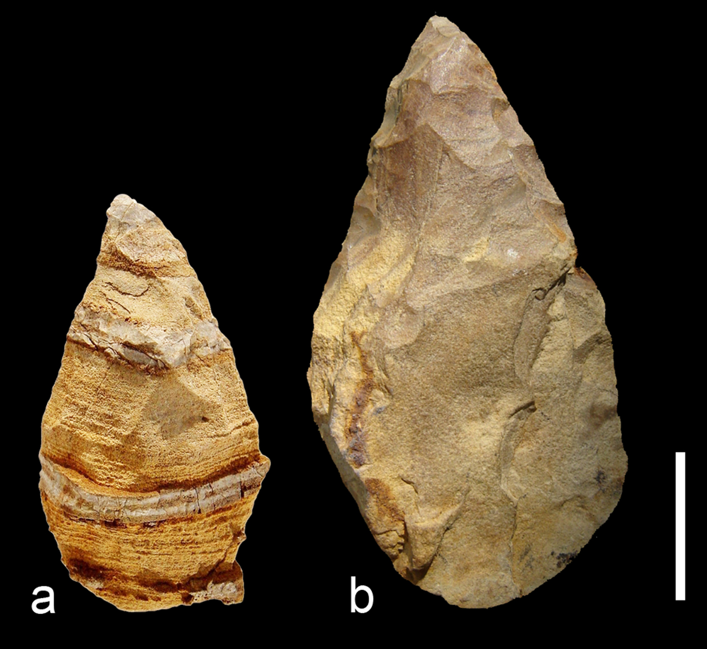
(color online) Campogrande area, CG9 locality (bifaces). (a) Unit CG9A, inventory no. M4150, biface in laminated limestone with interposed levels of silex; (b) unit CG9B, inventory no. M4158, biface in flint on a flake. Scale bar is 50 mm.
CG9B or “intermedio”
Only three flint bifaces were collected. The main features are common to the pieces of the other localities. They are made on a flake and pebble; the shaping covers a large part of one surface and especially the periphery and the extremity made by more removals (Fig. 8b; inventory no. M4158).
CG10A or “superiore”
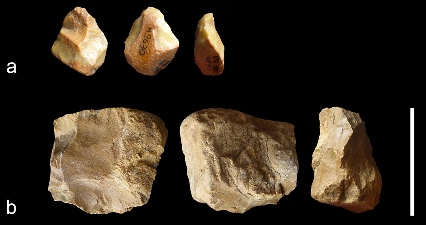
A dozen pieces can be described as cores and/or chopper-cores. They are made on small flint nodules/pebbles (50 mm long) and limestone oval and quadrangular pebbles of bad quality (Fig. 9a and b; inventory no. M7552 and M7868). The debitage always uses the natural morphology of the pebble or the nodule. It is orthogonal or unifacial unipolar (on the largest face or on the core edge). The number of removals is limited and products are irregular and frequently hinged. No preliminary preparation of the core is visible. Platforms are cortical or use the previous removals.
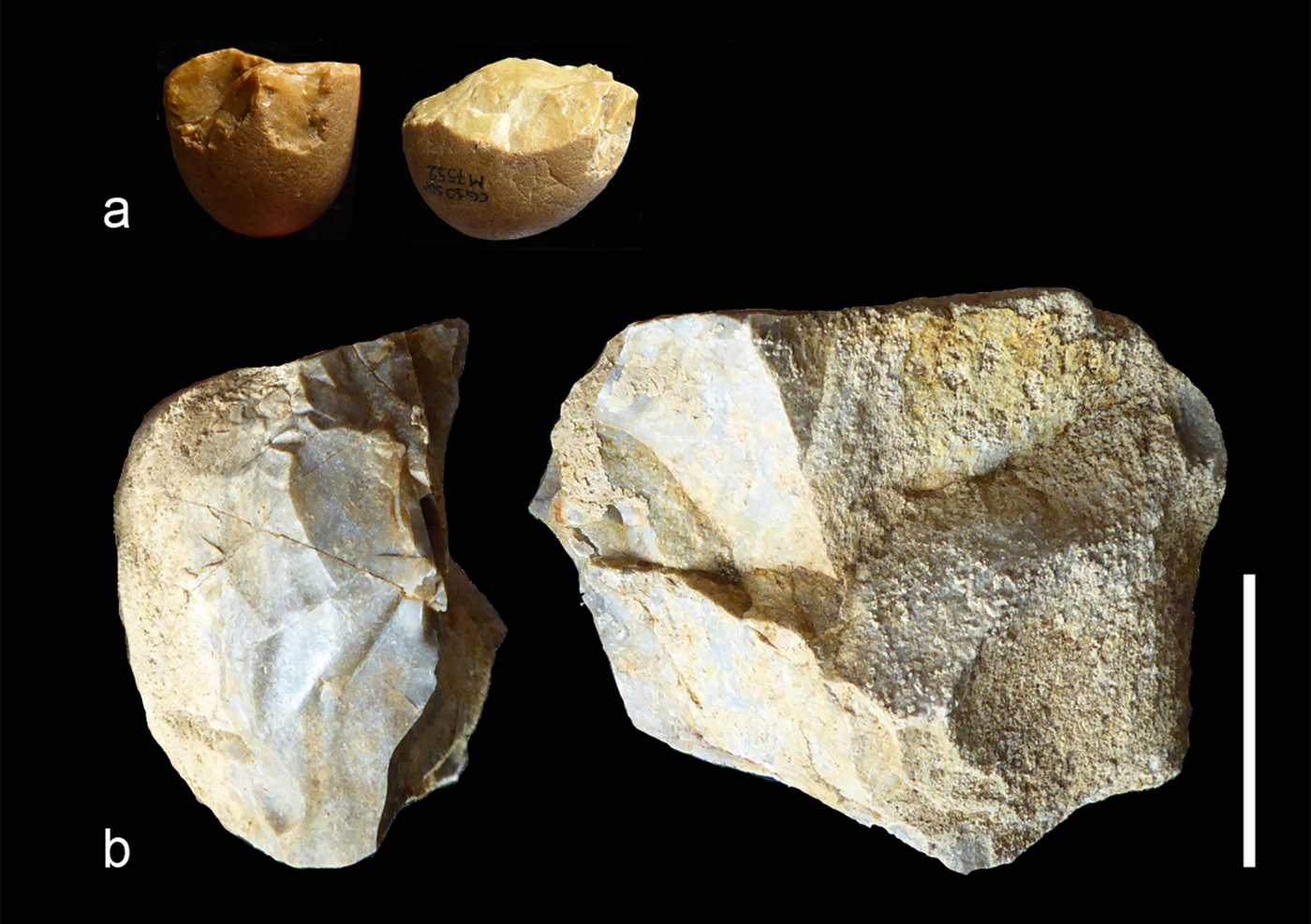
(color online) Campogrande area, CG10 locality (cores). (a) Unit CG10A, inventory no. M7552, small core on a flint pebble, where the debitage is on two orthogonal faces; (b) unit CG10A, inventory no. M7868, cores on flint pebbles with one or orthogonal flaking surfaces. Scale bar is 50 mm.
The series includes 22 heavy-duty tools, including mainly partial bifacial tools. They are only made on limestone. Three categories can be distinguished:
(a) A thick, pointed scraper (rabot-type) made by deep and large removals on a small part of the periphery of a broken limestone pebble (n = 1).
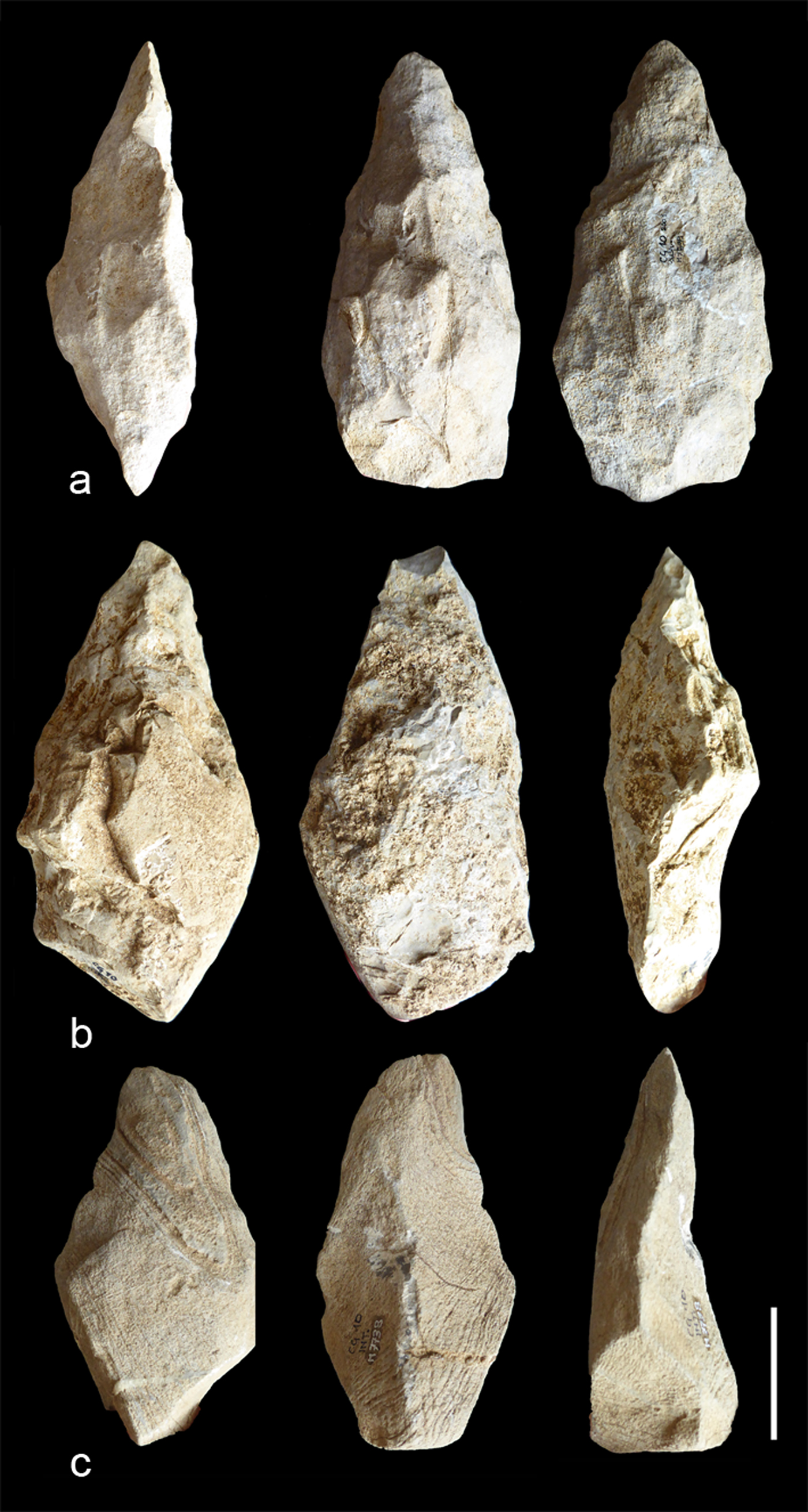
(b) Elongated, plano-convex bifaces (n = 5) on badly preserved limestone (Fig. 10a; inventory no. M7539). These tools are among the longest ones, around 200 mm. Some cortical residues suggest that the support could be a flat and elongated pebble. The whole bifacial volume is managed by one series of invasive removals on the two faces. Some removals are hinged. The shaping is alternate or face-by-face when visible. The edges are never rectified by retouches and they stay sinuous. The base of the tool is shaped by convergent removals (giving a thin cutting edge) or sometimes left unworked (back or natural round cortical base). The tip is always thin, and the shape, made by small removals, is included into the general shaping. The maximum thickness of the tool is on the proximal or the middle part of the biface. The cross section is always asymmetric, whereas the tool general form is symmetric.
(c) Partial bifacial tools on limestone (n = 16; Fig. 10b; inventory no. M7895). This category is more diversified than the previous one, in size and mode of shaping, with short and elongated pieces (from 110 to 210 mm). The support is a flake for most of the tools. The shaping concerns mainly the upper part of the tool, covering the two faces or only the periphery. In some cases, only the tip and one edge are worked, opposing the cutting edge to a back or a cortical side. The tip is pointed or round and made by small or large removals related to the shaping process of the lateral cutting edge(s). The base is always cortical, with or without a natural back. The cross section is plano-convex. The flattest face is covered either by large removals or by short removals limited to the upper part of the face. The opposite surface indicates series of semi-abrupt removals, rarely rectified by a final series of short removals and retouches. The cutting edges are consequently always sinuous. Removals are frequently hinged. One piece shows a longitudinal “coup de tranchet.” Another piece shows some transversal removals on the tip (perhaps due to use or resharpening). Most of the tools are asymmetric partial bifacial tools on limestone and the type of support seems to have played a major role, producing opposing flakes with a minimum shaping to an elongated pebble with a most invasive shaping. One series of removals characterize all the tools without final retouches giving sinuous edges. Besides the elongated bifacial pointed tools, some other bifacial tools preserve a backed edge as a main distinctive feature.
(color online) Campogrande area, CG10 locality (bifaces). (a) Unit CG10A, inventory no. M7539, asymmetric, elongated biface on limestone with whole shaping; note that the middle part of the tool is the thickest, removals cover the two faces, and edges are sinuous. (b) Unit CG10A, inventory no. M7895, partial bifacial tool on a limestone flake. Note that one series of removals is invasive and flat on one face and abrupt on the opposite face, the edges are sinuous, and a cortical back is preserved. (c) Unit CG10B, inventory no. M7738, limestone partial bifacial tool possibly on a flake, where the pointed upper part is worked with thin removals. Scale bar is 50 mm.
CG10B or “intermedio”
Except some cores on small flint nodules (less than 50 mm long) for the production of a few small flakes, the series is composed of both a heavy-duty and a light-duty component. The light-duty component is composed of a micro-biface on a limestone pebble, a micro convergent pebble-tool, and a point on a micro-flint nodule (30 to 50 mm long). They are minimally shaped by few unifacial and bifacial removals, which do not really modify the form of the pebble (Fig. 11a; inventory no. M9630). The heavy-duty tools are composed of one rabot, a thick scraper on a limestone half-pebble, and three bifaces in siltstone or quartzite (Fig. 10c; inventory no. M7738). The bifaces are mainly partially shaped. One shows a thick base. The shaping concerns the whole volume. Removals are abrupt on the two faces managed by an alternate shaping. The cutting edges are sinuous and without final retouches, while particular attention was paid in shaping the tip (more removals). The cross section is asymmetric. For the others, they are made on large flakes. The shaping is partially invasive, alternate, or face-by-face. The cross section remains symmetric. Removals are reduced on the base.
(color online) Campogrande area, CG10 locality. (a) Unit CG10B, inventory no. M7582, thick and asymmetric flint microlithic bifacial tool made by some removals. (b) Unit CG10C, inventory no. M10038, core on a flint nodule with small bifacial removals on part of the periphery. Scale bar is 50 mm.
CG10C or “inferiore”
No bifaces were found in this unit. Cores (n = 15) are made on small flint and quartz nodules/pebbles (Fig. 11b). They indicate an orthogonal or multidirectional debitage adapted to the form of the nodule or pebble, a transversal debitage (slices) on thick pebbles, and a bifacial debitage with asymmetric flaking surfaces. Removals are short, deep, and hinged due to the lack of preparation of the cores. Cores are left unexhausted due perhaps to inaccurate angles to continue flaking.
Interpretation of the archaeological assemblages
The Ceprano area represents a key site to describe in detail traditions after the end of MIS 12, based on various localities clustered in a small area. The quantity of artefacts collected in the CG localities is lower than at other nearby Middle Pleistocene sites, such as Colle Avarone (CA) and Lademagne (Biddittu and Segre, Reference Biddittu and Segre1977; Biddittu et al., Reference Biddittu, Canetri, Comerci, Germani, Picchi, Ghini and Mari2012). Comparisons, however, indicate common features of raw materials and technology in the CA and CG localities.
The CG series artefacts are mainly made on fine-grained limestone, associated with flint, quartzite, and quartz. The limestone is generally poorly preserved with smooth edges and breccia, whereas flint, quartzite, and quartz are fresher. Use of types of raw materials differs between the core technology and the shaping. It is likely due to the sizes of the available nodules and pebbles. Limestone is the main raw material for the bifaces and the heavy-duty component, completed by quartz, quartzite, and flint, possibly because limestone exists in various qualities as small and large pebbles on and in the surroundings of the localities. For the debitage, flint, then quartz and fine-grained limestone pebbles, are reemployed. Flint exists mainly under the form of small nodules; thus, it is mainly used for flaking except for CG10B and CG9B, where some bifaces are made from large flint supports.
The core technologies at the CG localities record the same technological features. Cores are small, on small flint nodules or pebbles of other materials. They do not indicate a preparation. The debitage is minimal and does not modify the form of the support. Cores are never exhausted. The debitage is performed on one or two faces, or orthogonal with mainly unipolar or crossed removals. Some round pebbles have been flaked by “slices.” There is no evidence of Levallois core technology in the CG localities, in contrast to the MIS 11/10 Italian site of Guado San Nicola, where the Levallois is represented by cores and flakes (Peretto et al., Reference Peretto, Arzarello, Bahain, Boulbes, Dolo, Douville and Falguères2016). The CG core technology resembles the debitage at Torre in Pietra (layer m; Piperno and Biddittu, Reference Piperno and Biddittu1978; Villa et al., Reference Villa, Soriano, Grün, Marra, Nomade, Pereira, Boschian, Pollarolo, Fang and Bahain2016) and La Polledrara (Anzidei et al., Reference Anzidei, Bulgarelli, Catalano, Cerilli, Gallotti, Lemorini, Milli, Palombo, Pantano and Santucci2012) made on small flint nodules.
The heavy-duty tools are the main component of the CG series. Three types of heavy-duty tools are common to the series but in different ratios: (1) elongated bifaces; (2) partial bifacial tools; and (3) heavy “scrapers” and “rabots.” The mode of shaping is not linked to the type of raw material since the bifaces made on flint share common technological features to the tools on other kinds of stones. On the other hand, the mode and intensity of shaping is necessarily consistent with the raw material and the shape of the original pebble. The partial bifacial tools are mainly made on flakes (easily identified) considered as preformed, which do not ask for a large management. Categories are not stages in a shaping process but distinct types of tools with specific purposes and sizes, although all are asymmetric tools in cross section. While bifaces show a symmetrical and elongated morphology, the partial bifacial tools are shorter and frequently asymmetric and transverse, although in a few cases they may have an elongated form. The bifaces are the longest pieces (around 200 mm). Some partial bifacial tools allow a resharpening since a limited part of the upper part of the tool is shaped by additional sectors. In contrast, most of the bifaces do not allow this resharpening without modifying the whole volume.
The CG localities offer the opportunity to observe technological trends and variability in a regional perspective and describe lithic series from close time periods in a small territory. The mode of shaping performed at Campogrande indicates both common and distinct features with some MIS 11–9 Italian sites in terms of shaping processes and morphological results. For instance, at Torre in Pietra, layer “m”, dated to MIS 10 (Villa et al., Reference Villa, Soriano, Grün, Marra, Nomade, Pereira, Boschian, Pollarolo, Fang and Bahain2016), most of the bifaces made from limestone or flint show an asymmetric cross section. The upper part is shaped without modifying the pebble form. The tip is pointed, and the base is left cortical. The shaping does not allow a resharpening. They closely resemble many of the CG bifaces. Equally, at Guado San Nicola, assigned to MIS 11/10 (Peretto et al., Reference Peretto, Arzarello, Bahain, Boulbes, Dolo, Douville and Falguères2016), bifaces total 3–4% of the series, made on flint and rarely silicified limestone, slabs, and some flakes. The raw material does not influence the mode of shaping, which provides asymmetric pieces. We observe a careful shaping of the tip with final retouches and a limited technical investment. The base is left cortical. Finally, at the more recent site of Castel di Guido, in MIS 9 levels (Radmilli and Boschian, Reference Radmilli and Boschian1996; Boschian and Saccà, Reference Boschian and Saccà2015), bifacial tools on fragments of Palaeoloxodon antiquus bones and stone pebbles indicate common shaping strategies at the site, whatever raw material is used, and common features with the Campogrande series.
DISCUSSION
Geological fieldwork and analyses coupled with the study of Paleolithic assemblages from localities close to the CG1 locality (the site where the Ceprano calvarium was discovered in 1994) enrich our understanding of human evolution in Europe during the second half of the Middle Pleistocene.
Combining sedimentological and archaeological data
The new and detailed stratigraphic and sedimentological data collected at Campogrande have provided further information on the history of the Lirino Lake, where the Ceprano calvarium was found. Our analysis of the stratigraphy of this area (c.f., Manzi et al., Reference Manzi, Magri, Milli, Palombo, Margari, Celiberti and Barbieri2010; Margari et al., Reference Margari, Roucoux, Magri, Manzi and Tzedakis2018) reinforces the conclusion that the hominin specimen was deposited in fluvial floodplain, constituting the final filling of the Lirino Lake.
These data, together with a series of chronological constraints (including K/Ar and Ar/Ar dates, paleomagnetism, and a combination of paleoenvironmental data) indicate that the age of the clay layer where the human specimen was found must be reasonably ascribed to MIS 11. This period was characterized by increasing volcanic activity in the area, as testified by the composition of the sediments. Thus, the K/Ar date of 385 ± 20 ka (Ascenzi and Segre, Reference Ascenzi and Segre1997a, Reference Ascenzi and Segre1997b) and the Ar/Ar date of 353 ± 4 ka (Nomade et al., Reference Nomade, Muttoni, Guillou, Robin and Scardia2011), which have been recorded in deposits at the top of the two drilled cores, C1 and C2, respectively, represent a terminus ante quem for the deposition of the human calvarium. The overlying sandy-gravel deposits forming the stratigraphic witness W (Fig. 3 and 7) and recorded also in the excavation test B (Fig. 3) are younger. They both include Paleolithic material with bifaces (archaeological unit CG9A), for which the dates at the top of C1 and C2 provide a terminus post quem.
The different localities of the Ceprano basin with lithic artefacts (Fig. 2) are scattered in a small area. Chronological data indicate that these sites and related archaeological assemblages are penecontemporaneous, allowing a comparison of technological behaviours after MIS 12, perhaps with the exception of the unit CG10C, which is characterized by flint and quartzite nodules/pebbles, with no bifaces, and appears more ancient from a stratigraphical point of view.
In general, the Campogrande series attest the occurrence of common regional trends of bifaces and bifacial tools with recurrent features, usually of large size (ranging in length from 50 to 260 mm), while technological strategies are common to other Italian sites. These trends in tool kits could indicate a network of connected sites along fluvial systems in the basin, documenting the use of abundant, available, local, raw materials. Future analyses of bone assemblages will help to understand type of sites, subsistence activities, and possible networks.
Large retouched fragments of bones of large mammals at most of the localities suggest affinities with other sites in central Italy, such as Fontana Ranuccio, Castel di Guido, Torre in Pietra, and La Polledrara di Cecanibbio (Biddittu and Segre, Reference Biddittu and Segre1980; Anzidei et al., Reference Anzidei, Bulgarelli, Catalano, Cerilli, Gallotti, Lemorini, Milli, Palombo, Pantano and Santucci2012; Boschian and Saccà, Reference Boschian and Saccà2015). This could explain why the core technologies exhibit minimal flaking aimed at rapidly producing useful flakes during short-term occupations. A heavy-duty component is also present occasionally and is not clearly explained by the stone availability. The quantity of flakes pointing to a shaping process in situ is often small and it is consequently difficult to investigate the status of these large tools. They could be mobile pieces moving between sites or expedient tools worked for the activities performed on each site.
Earliest and later Europeans
The still scanty fossil evidence of archaeological assemblages without bifaces—characterized by a heavy-duty component of pebble tools, cores, and flakes—includes the following sites: Atapuerca-Sima del Elefante (Carbonell et al., Reference Carbonell, Bermúdez de Castro, Parés, Pérez-González, Cuenca-Bescós, Ollé and Mosquera2008) and other sites near Orce, Spain (Toro-Moyano et al., Reference Toro-Moyano, de Lumley, Fajardo, Barsky, Cauche, Celiberti, Grégoire, Martinez-Navarro, Espigares and Ros-Montoya2009); Hérault, France (Crochet et al., Reference Crochet, Welcomme, Ivorra, Ruffet, Boulbes, Capdevila and Claude2009); and Arce, Colle Marino, Castro dei Volsci (Biddittu, Reference Biddittu1984), and Pirro Nord (Arzarello et al., Reference Arzarello, Marcolini, Pavia, Pavia, Petronio, Petrucci, Rook and Sardella2009), Italy. The assemblages of these early Lower Paleolithic sites indicate that scattered hominin settlements occurred in southwestern Europe during the late Early Pleistocene, probably earlier than 1.2 Ma.
The apparent absence of bifacial technology persists after 1.0 Ma. At the same time, discoveries in Spain, Italy, France, and England testify to the prompt onset before 500 ka of technologies that may be referred to as “Acheulean,” namely at Notarchirico, Italy (610–670 ka; Piperno, Reference Piperno1999; Lefevre et al., Reference Lefèvre, Raynal, Vernet, Kieffer and Piperno2010; Pereira et al., Reference Pereira, Nomade, Voinchet, Bahain, Falguères, Garon, Lefèvre, Raynal, Scao and Piperno2015), Arago in southern France (around 550 ka, levels P and Q), and La Noira, in central France (around 700 ka, lower unit, stratum a; Barsky and Lumley, Reference Barsky and de Lumley2010; Barsky et al., Reference Barsky, Garcia, Martínez, Sala, Zaidner, Carbonell and Toro-Moyano2013; Moncel et al., Reference Moncel, Despriée, Voinchet, Tissoux, Moreno, Bahain, Courcimault and Falguères2013; Falguères et al., Reference Falguères, Shao, Han, Bahain, Richard, Perrenoud and Moigne2015). Several sites along the paleo-Bytham in England yielded similar industries (Moncel et al., Reference Moncel, Ashton, Lamotte, Tuffreau, Cliquet and Despriée2015; Voinchet et al., Reference Voinchet, Moreno, Bahain, Tissoux, Tombret, Falguères and Moncel2015). In contrast, the recent discovery of La Boella in Spain (Vallverdu et al., Reference Vallverdú, Saladié, Rosas, Huguet, Cáceres, Mosquera and Garcia-Tabernero2014), with bifacial tools dated to 1 Ma–900 ka, reduces the chronological gap between Asia and Europe, raising questions as to the origin of the emergence (local or introduced?) of bifacial technology in the continent. In this framework, technological features of the earliest bifaces and lack of sites with evidence of a local emergence suggest the introduction of this technology on a cores-and-flakes substratum (Moncel et al., Reference Moncel, Despriée, Voinchet, Tissoux, Moreno, Bahain, Courcimault and Falguères2013).
The number of sites between 1 Ma and 500 ka suggest a low density of population, perhaps reflecting the isolation of small, mobile hominin groups, unable to maintain social networks or to occupy permanently the same area; this observation might explain the technological diversity between bifacial and non-bifacial industries (Moncel and Schreve, Reference Moncel and Schreve2016). Before 500 ka, hominins are inclined to occupy marginal areas only in favourable environments, especially in the north of the continent. Latitudinal climatic gradients are consistent with the persistence of occupations in the south during periods of climatic deterioration that affected northern and central regions (Moncel et al., Reference Moncel, Arzarello and Peretto2016). These climatic oscillations regularly forced hominins to retreat, expand, or even disappear from the region.
A large-scale expansion over Western Europe of Acheulean assemblages occurs after the cold phase of MIS 12, when various regional traditions were developing in both the north and south of Europe (Nicoud, Reference Nicoud2013; Moncel et al., Reference Moncel, Ashton, Lamotte, Tuffreau, Cliquet and Despriée2015; Ashton and Scott, Reference Ashton and Scott2016). The period of MIS 11–9 is thus a second crucial period, recording evidence of behavioural changes towards the early Middle Paleolithic, such as more complex and standardized core technologies, organized hunting, or changes in land use patterns (Moncel et al., Reference Moncel, Arzarello and Peretto2016). Early fire control (Roebroeks and Villa, Reference Roebroeks and Villa2011) could have contributed to new hominin abilities to expand territories and modify their behaviour. After 500 ka, diversity of technological behaviours again characterizes the industries, with or without bifacial tools, but this diversity is based on more numerous assemblages, which allow the identification of these trends. Changes in climate cycles, in demography, and in density of occupations could have influenced these behavioural changes, favouring the emergence of regional traditions, demographic expansion and genetic exchanges (growth and regular adaptation without demographic discontinuities), as well as new skills exemplified by more or less rapid processes of population dynamics and cultural changes (Grove, Reference Grove2016; Moncel and Schreve, Reference Moncel and Schreve2016; Moncel et al., Reference Moncel, Arzarello and Peretto2016).
The archaeological data from the Campogrande localities indicate that a kind of regionalization of archaeological traditions occurred at Ceprano-Campogrande after MIS 12. This seems related to the process of regionalization that involved both the north and the south of Europe (Ashton et al., Reference Ashton, Lewis, Parfitt, Penkman and Russell Coope2008; Scott and Ashton, Reference Scott, Ashton, Ashton, Lewis and Stringer2011; Ashton and Lewis, Reference Ashton and Lewis2012; Fontana et al., Reference Fontana, Moncel, Nenzioni, Onorevoli, Peretto and Combier2013; Brenet et al., Reference Brenet, Bourguignon, Colonges, Folgado, Jarry, Lelouvier, Mourre, Turq, Jaubert, Fourment and Depaepe2014; Garcia-Medrano et al., Reference García-Medrano, Ollé, Mosquera, Cáceres and Carbonell2015; Ashton and Scott, Reference Ashton and Scott2016) and seems resulting from a combination of some different elements: (1) the extended climate stability after the coldest event of MIS 12; (2) the occurrence of technological shifts that were deeply rooted in previous traditions; and (3) a possible significant increase in human population density (Premo and Hublin, Reference Premo and Hublin2009; Moncel et al., Reference Moncel, Moigne and Combier2012; Kleinen et al., Reference Kleinen, Hildebrandt, Prange, Rachmayani, Müller, Bezrukova, Brovkin and Tarasov2014; Wisniewski, Reference Wiśniewski2014; Limondin-Lozouet et al., Reference Limondin-Lozouet, Antoine, Bahain, Cliquet, Coutard, Dabkowski, Ghaleb, Locht, Nicoud and Voinchet2015; Lamotte and Tuffreau, Reference Lamotte and Tuffreau2016; Moigne et al., Reference Moigne, Valensi, Auguste, García-Solano, Tuffreau, Lamotte, Barroso and Moncel2016).
SUPPLEMENTARY MATERIAL
The supplementary material for this article can be found at https://doi.org/10.1017/qua.2019.52.
ACKNOWLEDGMENTS
After the discovery of the human fossil calvarium near Ceprano (FR) in 1994, field activities and related researches in the area of Campogrande have been authorized by the Soprintendenza A.B.A. e P. per le province di Frosinone, Latina e Rieti (formerly Soprintendenza Archeologica del Lazio), which we gratefully acknowledge. Both excavations and paleoenvironmental analyses were performed within the framework of the project “The Ceprano Calvarium and Its Environment,” which received grants attributed to one of us (G. Manzi) by the Sapienza University of Rome; we thank all the colleagues and students that have been involved in this project, including Fabio Parenti, for his support in recording the topography of the Campogrande area, and Veronica Munzi, who helped to collect and analyse part of the sedimentological data presented and discussed in this paper. The study of the archaeological record was financially supported by funding from the National Museum of Natural History, Paris, France: Acheulean in volcanic areas in Italy (Action Transversale du Museum). We are also grateful to the Editors (Nicholas Lancaster, Senior Editor, and Tyler Faith, Associate Editor) and the anonymous reviewers of Quaternary Research, for their extremely helpful criticisms and suggestions.


