

Introduction
The glacier inventory of Chile covers the Andean region from Arica (18˚ S) inthe north to the lake district (41˚ S) in the south, including 1675 individual glaciers with a total area of 6606 km2 (Reference CasassaCasassa, 1995; Reference Rivera, Casassa, Acuña and LangeRivera and others, 2000). These glacier inventories have been compiled largely by the Dirección General de Aguas (DGA; National Water Cadastre of Chile). The inventories and the study of glacier variations are especially important in basins close to populated areas in central-south Chile for estimating water resources and predicting future availability. This information is also important for studying climatic changes and for basic glaciological research.
In Patagonia, south of 41˚ S, detailed glacier inventories and variations have been compiled only for Hielo Patagónico Norte and Sur (HPN and HPS; northern and southern Patagonia icefields), which include a total glacierized area of 17200km2 and are by far the largest ice bodies in South America (Reference AniyaAniya,1988; Reference Aniya, Sato, Naruse, Skvarca and CasassaAniya and others, 1996, Reference Aniya, Sato, Naruse, Skvarca and Casassa1997). HPNlies entirely in Chile, while approximately 81 –92% of the area of HPS lies in Chile.
Two smaller icefields located south of HPS in Patagonia are currently being studied by multidisciplinary teams: Gran Campo Nevado in the southern part of península Muñoz Gamero (Reference Kilian, Biester, Müller, Eusterhues, Casassa and SchneiderKilian and others, 2000), with an approximate area of 200 km2; and isla Santa Inés to the south of the Strait of Magellan (personal communication from K. Bennet and V. Pojhola, 2001), with an estimated area of 100 km2. In Tierra del Fuego, recent variations of a few outlet glaciers of Cordillera Darwin (area approximately 2000 km2) have been determined (Reference Holmlund and FuenzalidaHolmlund and Fuenzalida, 1995). Glaciological measurements are being performed by C. Porter (personal communication, 2001) at a few outlet glaciers of Cordillera Darwin and the small ice cap of isla Hoste located south of the Beagle Channel, with an estimated area of 150 km2 (Reference CasassaCasassa, 1995).
Large glacierized areas in southernmost Chile are virtually unstudied, with neither a glacier inventory nor an assessment of ice variations. The total uninventoried glacier area in Chile between 41˚ and 55˚ S is estimated as 5200 km2 (Reference Rivera, Acuña, Casassa and BrownRivera and others, 2002). This paper describes the first glacier inventory for península Córdova, isla Riesco, based on aerial photographs. The inventory is extended to all of isla Riesco using a Landsat TM image and a simple lineal algorithm to correct for enhanced snow cover at the time of image acquisition.
Site Description
Isla Riesco is a large island oriented approximately east–west, stretching from 52°40’ to 53°30’ S and 73°30’ to 71°20’W, about 130 km long and 50 km wide (Fig. 1). It is bounded to the north by Skyring sound, to the south by Otway sound, to the east by Fitz Roy channel, to the west by Gajardo channel, to the southwest by the Strait of Magellan and to the southeast by Jerónimo channel. Large Pleistocene glaciers occupied each of these waterways during the Last Glacial Maximum (Reference ClappertonClapperton, 1993). Península Córdova is located at the southwestern end of isla Riesco, along the northern flank of the Strait of Magellan (Fig.1).
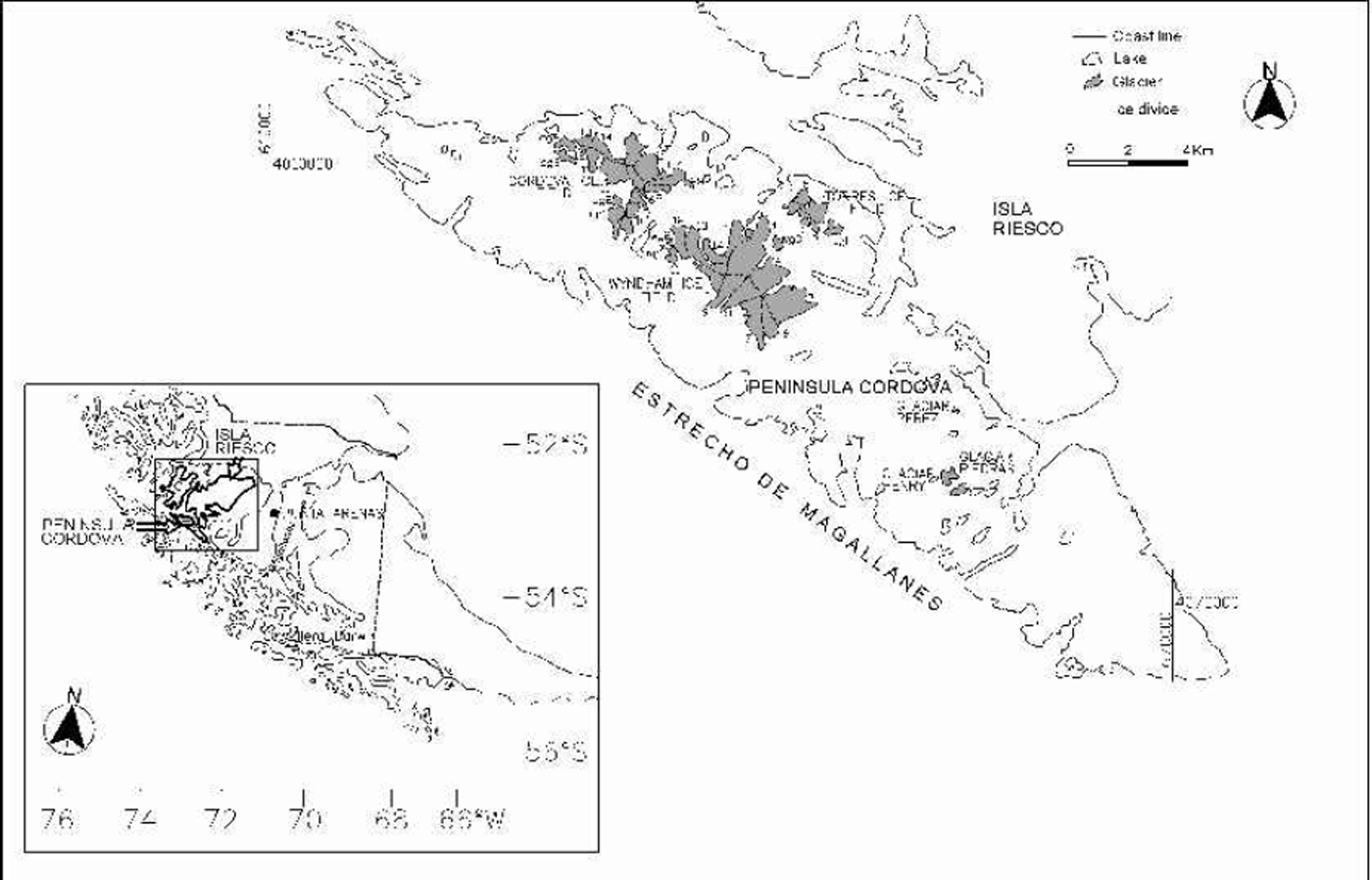
Fig. 1. Glaciers of península Córdova, isla Riesco. Numbers and names correspond to the list in Table 1. Gridlines are expressed as Universal Transverse Mercator (UTM) coordinates. The inset shows the coastline of isla Riesco drawn with a thick line, where Península Córdova appears on the lower left of the island. G is Gran Campo Nevado icefield, located on península Muñoz Gamero.
The eastern part of the island is relatively flat and has moderate precipitation (<1000mma–1; DGA, 1987) because it is located leeward of the Andes mountains. A few farms exist in this part of the island, mainly involved in cattle raising. The island has two gravel roads, each with a maximum length of about 50 km, located along the shores of Skyring and Otway sounds. The western part of isla Riesco is located within the main belt of the Andean cordillera, with high precipitation rates (41000 mma–1) driven by the strong westerly circulation. In this western sector, which is virtually uninhabited, the highest mountain peaks have an elevation of 1830 m, including several small ice caps and mountain glaciers.
Sixty kilometres northwest of península Córdova lies Gran Campo Nevado, an ice cap of about 200 km2 (Reference Casassa, Espizúa, Francou, Ribstein, Ames, Alean, Haeberli, Hoelzle and SuterCasassa and others, 1998), which is presently being studied by a multidisciplinary German group (Reference Kilian, Biester, Müller, Eusterhues, Casassa and SchneiderKilian and others, 2000). Preliminary meteorological measurements show an annual precipitation of about 9 ma–1 at canal Gajardo on the coast (personal communication from C. Schneider, 2001), which is probablyalso representative for the westernmost part of isla Riesco.
Methods And Data
Aerial photographs
Vertical aerial photographs for península Córdova of March and December 1984 provide complete coverage during a period with relatively small snow accumulation. These photographs were acquired by Servicio Aerofotogramétrico of the Chilean Air Force with a 23623 cm format and a nominal scale of 1:60 000. The only other aerial photographs available for the area are the Trimetrogon vertical and oblique photographs acquired by the U.S. Air Force in 1944/45. Glacier boundaries, which generally appear quite distinct on the 1984 photographs, were plotted stereoscopically. Glacier margins were then drawn on 1:100 000 maps of Instituto Geográfico Militar (IGM) sheets Golfo Xaulteguaand Estuario Wickham, using a monoscopic Zoom Transfer Scope of Bausch and Lomb. Three icefields and 12 small glaciers were detected on península Córdova (Fig. 1). For the icefields, individual catchment areas were identified for each glacier tongue, based on estimated ice divides according to the 1:100000 IGMmaps.
The glacier margins and ice divides for península Córdova were digitized and imported as vector files to AutoCAD digital cartographic software. Polygons were defined semi-automatically using a topological scheme, calculating areas, lengths and mean glacier coordinates digitally. Glacier aspect, elevations and relief were estimated directly on the 1:100 000 maps.
Satellite imagery
One Landsat TM image acquired on 6 October 1986 was available for isla Riesco (Fig.2). The image has a nominal pixel resolution of 28.5 m, and is almost entirely cloud-free, except for a small section southeast of península Córdova, near Jerónimo channel. Snow cover is unfortunately very extensive in the image, due to the early-spring acquisition period, making it difficult to distinguish glaciers from snow cover.
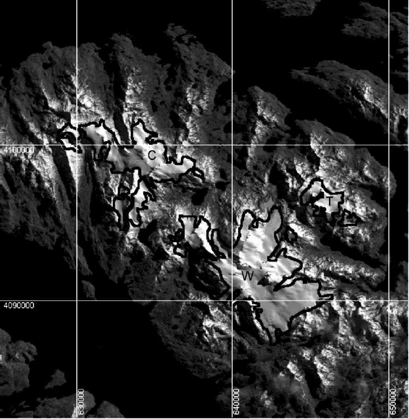
Fig. 2. Band 4 data (near-infrared) of a Landsat TM image of Córdova icefield (C),Wyndham icefield (W) and Torres icefield (T) at península Córdova, acquired on 6 October 1986. The thick black line shows the glacier perimeter interpreted from the aerial photographs. Glaciers appear larger in the image due to extensive snow cover at the time of image acquisition. Gridlines correspond to UTM coordinates.
The image was geometrically rectified using a second-order polynomial based on 38 points identified from the 1:100 000 maps, evenly distributed along isla Riesco. The mean registration error is 1.3 pixels (36m), although maximum errors as large as 3 pixels (86m) were detected at some locations relatively far from control points.
A supervised maximum-likelihood classification according to Reference Engman and GurneyEngman and Gurney (1991) was carried out for isla Riesco for the classes sea water, shadow, clouds, glacier, snow and inland lake using Erdas Imagine 8.4 image-processing software. This semi-automatic technique did not perform adequately because glacier and snow were not clearly distinguished in the image. Instead, an on-screen digitizing of polygons of glaciated areas was carried out using a combination of bands 4, 5 and 7 which provided a satisfactory visualization. Combinations such as Landsat TM band 4/band 5 (near-infrared), which are typically used to distinguish snow from glacier ice (Reference Engman and GurneyEngman and Gurney, 1991), did not perform adequately either, which is not surprising considering that probably fresh snow covered all of the glacier and some of the rock area at the time of image acquisition.
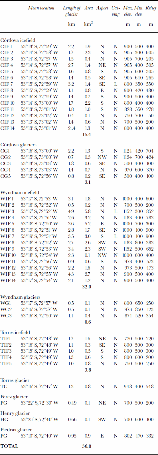
By using the on-screen digitizing scheme in combination with the unsupervised classification, an improved glacier area estimate was obtained for isla Riesco. Glacier areas were calculated digitally on the image using Idrisi 32 image-processing software, and are shown in Figure 3.

Fig. 3. Band 4 data (near-infrared) of the 6 October 1986 Landsat TM image for the central-western part of isla Riesco. The thick white lines show the glacier perimeter interpreted using a supervised classification as described in the text. Gridlines correspond to UTM coordinates.
Glacier Inventory
Inventory of península Córdova derived from aerial photographs
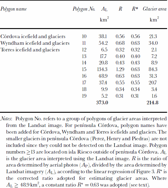
Three small icefields were identified at península Córdova from the aerial photographs: Córdova, Wyndham and Torres icefields (Fig. 1), with an area of 15.4, 32.0 and 3.8 km2, respectively. These icefields can be divided into 33 smaller catchment areas, each corresponding to a different glacier tongue that could be identified on the photographs. In addition,12 separate small glaciers were found, with a total area of 5.6 km2. Considering both icefields and glaciers, the glacierized area for península Córdova is 56.8 km2.
The glacier inventory is shown in Table 1, including mean latitude, longitude, length, area, aspect, nature of terminus, elevation and relief. Only three glaciers calve into small fresh-water lakes, the rest terminate on land, and none of the glaciers reaches sea level. No predominant glacier aspect can be found, and glaciers radiate in all directions. Accumulation and ablation areas could not be identified, because the local equilibrium-line altitude (ELA) is unknown(see next section).
Table 1. Glacier inventory for península Córdova. Calving column: N, non-calving glaciers; L, glaciers calving into freshwater lakes
The maximum elevation of península Córdova is 1183m at Mount Wyndham, the highest point of Wyndham icefield, whereas the minimumelevation of glaciers on the peninsula is 100m, corresponding to the elevation of the proglacial lake of glacier 7 of Wyndham icefield. The second lowest glacier-front elevation is 300 m. The mean highest elevation for all glaciers is 867 m, while the mean elevation of the glacier fronts is 497 m, yielding an overall average elevation of 682 m for the glaciers. Maximum elevations for some glaciers such as CG3 and CG5 (Table 1; Fig. 1) are probably underestimated because of the low resolution of the 1:100 000 scale maps.
The above information indicates that glaciers at península Riesco are clearly confined to the mountain slopes, with small accumulation areas and with ablation areas that do not extend much beyond the mountain slopes. The only exception is glacier 7 of Wyndham icefield, which has a higher and larger accumulation area, with ice draining down to an elevation of 100 m in the ablation area.
Inventory of isla Riesco derived from the Landsat image
The Landsat image can be used to assess the glacier area for the rest of isla Riesco. This is done in the following way. Firstly, we can compare the glacier areas obtained for península Córdova by aerial-photograph interpretation, calculated as 56.8 km2, and by Landsat image analysis, which results in 98.7 km2. The areal overestimation of 74% using the Landsat image is clearly a consequence of interpreting seasonal snow present at the time of acquisition (early spring) as glacier ice. Assuming that the rest of isla Riesco has a similar snow cover at the time of image acquisition, we could simply estimate the glacier area from the analysis of the Landsat imagery, and reduce this area by the reciprocal of the overestimation factor (i.e.1.74) calculated for península Córdova, that is 57%.
A more accurate procedure to assess glacier coverage from the Landsat image was found by comparing the area of individual ice bodies estimated from the Landsat image with the area derived from the aerial photographs at península Córdova (Table 2; Fig. 4). The ratio (R) of the glacier area obtained by aerial photographs (AP) and the area obtained by the Landsat image (AL), calculated as the ratio R = APAL–1, was found to be linearly dependent on AL, as a first-order approximation, for AL values of 1–47km2. This means that the glacier-area overestimation associated with the Landsat image interpretation is larger for smaller glacier areas. The largest ice mass in península Córdova is the Wyndham glaciers, with AL = 47 km2 and R = 0.63. For areas exceeding 47 km2 a constant ratio of 0.63 was adopted to avoid obtaining unrealistically large values of R. In fact, glacier areas of 447 km2 on the Landsat image are also largely covered by fresh snow, thus overestimating the real glacier extension.

Fig. 4. (a) Plot of glacier areas interpreted from a supervised classification of the 6 October 1986 Landsat image (AL : x axis) vs the area interpreted from aerial photographs of 1984 (AP : y axis). (b) Plot of AL (x axis) vs ratio of APAL –1 (y axis). Numbers attached to data points represent areas obtained from the Landsat image, in km2(AL ). Data points correspond to the following glaciers: 1. Perez glacier; 4. Piedras and Henry glaciers; 9. Torres icefield and Torres glacier; 38. Córdova icefield and CG1–CG5; 47 .Wyndham icefield and WG1–WG3. The line represents a best linear fit with y= 0.0076x+0.269, and r= 0.84, valid for 1 ≤ AL ≤ 47 km2. For AL 447 km2 a constant value of AP=AL = 0.63 is assumed (see text).
Table 2. Estimated glacier areas for isla Riesco
Notes: Polygon No. refers to a group of polygons of glacier areas interpreted from the Landsat image. For península Córdova, polygon names have been added for Córdova,Wyndham and Torres icefields and glaciers. The smaller glaciers in península Córdova (Perez, Henry and Piedras) are not included since they could not be detected on the Landsat image. Polygon numbers ≥13 are located on isla Riesco outside of península Córdova. AL is the glacier area interpreted using the Landsat image. R is the ratio of area determined by aerial photos (AP), divided by the area determined by Landsat imagery (AL), according to the linear regression of Figure 3.R¤ is the corrected ratio adopted for estimating glacier areas. Where AL ≥ 48.9 km2, a constant ratio R* = 0.63 was adopted (see text).
The total glacier area for the rest of isla Riesco, corresponding to polygons 13–19 in Table 2, is 157 ±40km2. Adding this area to the glacier-covered area of península Córdova obtained by aerial photographs (56.8km2) yields a total glacier area of 215 ±40 km2 for isla Riesco, neglectingerrors in the area calculation using the aerial photos. The value of 215 km2 is more than double the previous estimate of 100 km2 (Reference CasassaCasassa, 1995), which was calculated based on 1:250000 maps. This shows the need for an improved inventory based on new observations. Considering the high cost of acquiring dedicated aerial photographs, particularly suitable is satellite coverage obtained in a more convenient season (minimized fresh snow cover) with unsaturated pixels over snow and ice and increased resolution compared to Landsat TM. Landsat 7 and the Advanced Spaceborne Thermal Emission and Reflection Radiometer (ASTER) offer possibilities for such coverage.
Glacier Variations And Sensitivity To Regional Climatic Change
No field data exist for the ELA on isla Riesco. Likewise, the ELA could not be estimated based on 1984 aerial photography or using the 1986 Landsat image, because of image saturation and lack of contrast between snow and ice. Although glaciers show some signs of retreat (see below), it is reasonable to estimate that they have a meaningful accumulation area to replenish at least part of the ablated ice. Therefore, the equilibrium line should be located below 900 m, where nearly all glaciers are located, but above 500 m, the average elevation of glacier fronts, which are located on relatively steep mountain slopes. Any changes in ELA should affect small areas of the glaciers, so the glaciers of isla Riesco should be rather insensitive to climate change (Reference Furbish and AndrewsFurbish and Andrews, 1984; Reference Tangborn, Fountain and SikoniaTangborn and others, 1990).
The presence of trimlines above present ice surfaces, and moraines beyond the present position of the glaciers as observed on aerial photographs, indicates that the glaciers of isla Riesco are in a general state of retreat from a Holocene neoglacial, as is evident in other glaciers of southern South America (Reference ClappertonClapperton, 1993; Reference Aniya, Sato, Naruse, Skvarca and CasassaAniya and others, 1997; Reference Rivera, Acuña, Casassa and BrownRivera and others, 2002). The glacier retreat can probably be correlated with the regional warming of 1.3–2.0°C (100 years)–1 observed in Chile during the last 60 years (Reference Rosenblüth, Casassa and FuenzalidaRosenblüth and others, 1995), a trend which is also observed in Argentine Patagonia (Reference Ibarzabal y Donángelo, Hoffmann and NaruseIbarzabal and others, 1996). Another factor which should contribute to glacier recession is the precipitation decrease of 25–33% detected at faro Evangelista and bahía Félix stations during the periods 1899–1988 and 1915–85, respectively (Reference Rosenblüth, Casassa and FuenzalidaRosenblüth and others, 1995). In the last 15 years, however, a few regional stations show a precipitation increase, as well as an apparent reduction in climate warming (personal communication fromJ. Carrasco, 2000]), which may result in a future glacier stabilization or readvance.
Conclusions
Analyses of aerial photographs acquired during mid- and late summer, in combination with 1:100 000 topographic maps, proved adequate for compiling a glacier inventory for península Córdova, isla Riesco. The inventory was extended to all of the western part of isla Riesco using a Landsat TM image acquired in early spring, which shows abundant snow coverage, including glacier-free areas. Although the image does not clearly distinguish between seasonal snow areas and glacier areas, a supervised classification method, in combination with an on-screen image interpretation scheme, was adjusted for the glacier area of península Córdova and allowed to extrapolate the glacier inventory for all the western part of isla Riesco, yielding an approximate total glacier area of 215±40 km2 for the island.
Acknowledgements
Part of this work was funded by project FONDECYT 1980293 and by an internal project of Universidad de Magallanes. Centro de Estudios Científicos is a Millennium Science Institute. Aerial photographs were kindly loaned by Empresa Nacional del Petróleo, Punta Arenas, Chile. C. Acuña provided valuable assistance with digital cartography and photo interpretation at Departamento de Geografía, Universidad de Chile. A student scholarship from the Technical University of Denmark funded the stay of K. Smith in Punta Arenas. R. Kilian kindly provided access to the Landsat image.


