




Introduction
Until recently, the history of the Second Plague Pandemic—from its first wave (the Black Death of 1338–53) onward—was studied largely from a Eurocentric perspective, with a few notable exceptions.Footnote 1 More recently, conceptual and methodological shifts have reframed plague as a global disease, integrating non-European regions into scholarly analysis, particularly the Middle East and Central Asia,Footnote 2 the Great Lakes region of sub-Saharan Africa,Footnote 3 and Yemen.Footnote 4 This shift is driven primarily by advances in the evolutionary and (palaeo-)genetic study of Yersinia pestis, which have transformed our understanding of plague’s global history and underscored the value of integrating (palaeo-)genetics with historical research.Footnote 5 Although this interdisciplinary approach—combining written sources with aDNA and other non-textual evidence—has so far been adopted by relatively few plague historians, it is clearly gaining momentum.Footnote 6
This more global and interdisciplinary approach to plague history has raised new questions, notably concerning the origins of plague reservoirs and recurrent waves during the Second Pandemic. While some scholars argue that later outbreaks were repeatedly reintroduced from Asia,Footnote 7 others posit the existence of regional ‘domestic’ reservoirs, particularly in Europe. Various areas—including southern Russia,Footnote 8 the Caucasus-Volga region,Footnote 9 Moldova-Wallachia,Footnote 10 the south-west Balkans,Footnote 11 the Peloponnese,Footnote 12 the Marseille region in Provence,Footnote 13 the Swiss Alps,Footnote 14 and EnglandFootnote 15 —have been proposed. Recent textual and aDNA evidence has shown that the pestis secunda wave (1356–66) originated in a south-central German reservoir,Footnote 16 with additional plague foci likely in southern Germany.Footnote 17
Another major historiographic issue concerns the role of maritime and inland trade networks in the transregional spread of plague. The trade–plague nexus was already proposed in the early nineteenth century by figures such as Schnurrer, Hecker, Gasquet, and Nohl—who (incorrectly) posited a Chinese origin of the Black Death and (correctly) argued for Central Asian routes of plague transmission.Footnote 18 However, it is only in recent scholarship that trade has been subjected to sustained analytical scrutiny, demonstrating that plague transmission along Eurasian networks was shaped above all by political-military conditions, economic and commercial institutions, and eco-climatic factors.Footnote 19
A further contested issue in plague history concerns the impact of eco-climatic factors on plague activity. This is particularly important given that plague is fundamentally an enzootic disease of wild rodents, crossing into human populations only under specific conditions (as at least 60 per cent of all known and 75 per cent of new emerging infectious diseases).Footnote 20 Although the role of ecology and climate has long been acknowledged,Footnote 21 it has often remained abstract or conjectural, largely because the spatio-temporal contours and geographic origins of successive plague waves have only recently begun to be clarified. Without establishing where and when plague activity emerged, the influence of environmental forces cannot be properly assessed.
This article integrates the southern Red Sea region into the global history of the Second Plague Pandemic by examining plague’s (re-)introduction in the 1430s—most likely from Egypt (where it had been rife in 1429–30)—and its subsequent focalisation there.Footnote 22 In doing so, it contributes to broader debates on plague origins, trade-mediated transmission, and eco-climatic drivers, moving beyond Eurocentric and single-disciplinary perspectives. It addresses three core questions: when and how plague entered the region; the role of long-distance trade in its spread; and the environmental conditions that enabled the formation of local reservoirs.
Recent historiography has stressed the role of transregional trade—both long- and medium-distance, inland and maritime—in shaping the spread of plague.Footnote 23 In the Red Sea region, the structures and infrastructures of international trade created favourable conditions for the relatively direct and unimpeded movement of the disease from Cairo to its eventual focalisation in the highlands of Ethiopia and Yemen. The early fifteenth century was a comparatively stable period, during which long-distance trade and travel between Mamluk Egypt, Ethiopia, and Yemen were particularly buoyant, as attested by both textual and archaeological evidence. People and goods circulated regularly along well-established maritime and overland routes, linking commercial hubs, educational institutions, and religious centres—categories that often overlapped.Footnote 24 Among the commodities traded, grains and textiles, temporarily stored in sacks, could function as ‘very short-term’ plague reservoirs, transporting Yersinia pestis via infected ectoparasites (and occasionally commensal rodents). In Yemen, lowland Ethiopia, and along the Somali coast, merchandise was transported predominantly on camelback, a practice that may have further facilitated the interregional spread of plague, not only because camels could traverse vast distances, but also because they themselves could serve as potential plague hosts.Footnote 25
Within Ethiopia and Yemen proper, local economic structures—both agricultural and commercial—also appear to have played an important role in facilitating plague spread, during both its initial introduction in the 1430s and subsequent recurrent waves from the fifteenth to the seventeenth centuries (and, in the case of Yemen, possibly beyond). Many villages were situated along transregional trade routes, while agricultural activities—ploughing, sowing, harvesting, threshing, transporting, and storing crops—brought rodents into ever closer proximity with human settlements.Footnote 26 The storage, movement, and marketing of crops across local and regional markets would, in turn, have promoted the spread of plague at both regional and transregional scales.
Thus, at the epidemiological level, the article delineates regional, short-term ‘transient’ and medium-term reservoirs in Ethiopia and Yemen, characterised by distinct eco-climatic and zoological configurations. As such, this case study offers a valuable point of comparison with plague reservoirs identified in other regions of the world and across different chronological contexts. At the historical level, it highlights the analytical gains of focusing on both interregional and intraregional networks, and serves as an example of scholarship that moves across linguistic, religious, and national boundaries.
Yemen and Ethiopia have not received much scholarly attention in the context of plague history. Apart from Richard Pankhurst’s classical article and monograph on famine and epidemics in pre-modern Ethiopia, and Marie-Laure Derat’s article on epidemic outbreaks in the early Solomonic period, there are no studies on the subject.Footnote 27 As far as Yemen goes, a recent article by Philip Slavin analysed the ecology of a local highland reservoir, possibly situated in the Ibb region, active in the period c.1436–1558.Footnote 28 Otherwise, plague in Yemen has been addressed only in passing, typically through brief mentions of the 1435–37 outbreak in studies concerned with the socio-economic history of the Rasūlid period (1229–1454).Footnote 29
To address the gap, the article makes use of both written sources from Egypt, Yemen, and Ethiopia and non-textual data. The first category includes Mamluk- and Rasūlid-era Arabic chronicles, some Gǝʿǝz hagiography, Rasūlid almanacs, and agricultural treatises, as well as Arabic, Italian, and Portuguese travelogues. The second category, complementing the first one, consists of archaeological findings at both Christian and Muslim sites of Ethiopia and palaeoclimatic evidence (sediment record from Lake Hayq and the stalagmite record from Hoti Cave in Oman). In theory, these sources are to be supplemented with palaeogenetic data, but so far no ancient DNA has yet been recovered from any historical context in the Red Sea region. The closest available proxy is a single isolate from a 1969 outbreak in the Ḫawlān region of Yemen—most likely associated with the ʿAsīr reservoir—which could not be incorporated into the study, but which has been discussed in the supplementary information material (SI), details of which are given at the end of this article, and elsewhere.Footnote 30 The SI together with the SI Tables, contain detailed information plague outbreaks in southern Red Sea region, as well as rodents likely maintaining plague reservoirs of Ethiopia and Yemen.
Based on the available evidence, this article reconstructs the main contours of plague arrival in the southern Red Sea region in the 1430s and argues that its introduction was followed by the establishment of a medium-term reservoir responsible for recurrent epidemic waves. To explain this process, it analyses environmental and institutional factors as exogenous and endogenous enablers operating in tandem and facilitating the persistence and spread of plague in the region over the following 150–200 years.
Plague in the southern Red Sea region: Some basic concepts
To avoid any potential disambiguation, it is necessary to define the ‘southern Red Sea’ as a region covering Ethiopia–Eritrea, the Somali coast, and Yemen. In the present article, ‘Ethiopia’ or ‘Abyssinia’ (used interchangeably) is defined as an area overlapping roughly with today’s Ethiopia, Eritrea, as well as parts of neighbouring countries; it consisted of the Christian Abyssinian empire ruled by the Solomonic dynasty since 1270, the Muslim sultanate of Adal, and a series of smaller polities including Dankali, Ajuran, various Oromo chiefdoms, and the kingdom of Kaffa.
Before turning to plague in the southern Red Sea region, a few key terms require definition. Plague is a zoonotic infectious disease caused by Yersinia pestis, maintained primarily in wild rodent reservoirs and only occasionally transmitted to humans. In nature, the bacterium persists in ecological foci—combinations of biotic and abiotic factors that enable long-term survival. Plague most commonly appears in bubonic form, but may also be septicaemic, pneumonic, or, rarely, gastroenteritic. Yersinia pestis is over 6,000 years old and has been identified in late Neolithic and Bronze Age aDNA across Eurasia.Footnote 31 In the Red Sea region, plague is attested during the First (c.541–770), Second (c.1338–1844), and Third (c.1894–1950) Pandemics; its arrival in the Red Sea in the 1430s thus should be regarded as its ‘reintroduction’, rather than ‘introduction’.Footnote 32
Plague terminology in the southern Red Sea region is often imprecise. In Arabic sources, the only term that reliably denotes plague is ṭāʿūn, though authors sometimes used broader terms such as wabā ʾ (‘epidemic’ or ‘pestilence’), and more rarely mawt (‘mortality’) or fanā ʾ (‘destruction’). This reflects the well-known maxim—attributed to Yaḥyā ibn Sharaf al-Nawawī (c.1230–77) (who himself drew his knowledge on plague from historical sources on the First Plague Pandemic, as there were no plague outbreaks in the Middle East or elsewhere in Western Eurasia in his own day)Footnote 33 —that ‘every ṭāʿūn is a wabā ʾ, but not every wabā ʾ is a ṭāʿūn’, a distinction widely cited by later Mamluk scholars.Footnote 34 Late Rasūlid sources mirror Mamluk chronicles from Syria and Egypt in showing that epidemic terminology was approximate rather than precise: while ṭāʿūn in the context of the Second Pandemic clearly denotes plague, the same disease could also be described using more generic terms, especially wabā ʾ, and occasionally mawt or fanā ʾ—as shown below. In Gǝʿǝz sources, the situation is even less straightforward, with most commonly used terms in plague contexts being bedbed (ብድብድ, meaning ‘pestilence’ or ‘epidemic’ and paralleling the Arabic wabā ʾ) or mota bedbed (ሞተ፡ ብድብድ, meaning ‘pestilential death’).Footnote 35
Plague in Ethiopia, c.1431–35
Around 1430, Niccolò de’ Conti, a Venetian merchant visiting the port of Berbera on the Somali coast, claimed that the Abyssinians enjoyed long lives and rapid population growth because they knew no pestilence.Footnote 36 He was mistaken. Contemporary Mamluk and Ethiopian sources indicate that an epidemic—apparently plague—was raging in Abyssinia at the time. One Gǝʿǝz account reports a plague outbreak around 1432 at the monastery of Dabra Demāh in southern Eritrea, which was subsequently abandoned for 175 years.Footnote 37 Al-Maqrīzī likewise notes that plague was widespread in bilād al-Ḥabasha before reaching Berbera and Aden, killing many, including the Christian king, probably Sārwe ʾIyāsus (reigning November 1433–June 1434), followed by the brief reign of ʿAmda ʾIyāsus. Plague also affected the sultanate of Adal in 839 ah (1435–36 ce), causing deaths among both Christian and Muslim populations.Footnote 38
Juxtaposing the chronology of the two accounts together, we may deduce that the plague wave commenced in the Solomonic empire, before spreading eastwards into the Adal sultanate and crossing from Berbera to Aden. Although there are references to ‘pestilence’ (bedbed ብድብድ) or ‘pestilential death’ (mota bedbed ሞተ፡ ብድብድ) in the later fourteenth and early fifteenth centuries in Gǝʿǝz sources (including references to epidemics c.1370, c.1403, and c.1420), we do not know if these were indeed plague outbreaks.Footnote 39 Even if they were, we do not know if plague had focalised in Abyssinia before the early 1430s wave, or if these outbreaks (both the 1430s one and the previous ones) were imported from outside, with Mamluk Egypt being the most obvious candidate.
One possibility—assuming an external introduction—is that the Abyssinian outbreak of c.1432–35 was linked to the same plague wave that devastated Mamluk Egypt in 1429–30. Mamluk sources trace this wave from the Volga (bilād as-Sarāy) and Pontic–Caspian regions (dasht-i Qipchāq) around 1427–29, through Anatolia and Syria (bilād al-Shām), reaching Ramla, Jerusalem, and Gaza in spring 1429, the Egyptian Delta in late 1429, Cairo and Alexandria in early 1430, and Upper Egypt by April.Footnote 40 This spatio-temporal pattern suggests a southward trajectory. Although evidence for plague south of Upper Egypt is lacking, it may have continued via the Nile and Eastern Desert caravan routes into Sudan and the Solomonic empire. While Ottoman-era sources suggest plague rarely spread beyond the Second Cataract, exceptional environmental and demographic conditions could permit such movement, as seen during the 1694–97 famine, when plague appears to have reached the Great Lakes region of East Africa.Footnote 41
Several fifteenth- and early sixteenth-century Venetian travel manuals estimate the uninterrupted travel time between Cairo and ʾAksum at 84 to 89 days, and that between Cairo and Barārā (a major commercial hub, close to Addis Ababa) at 163 to 168 days.Footnote 42 Hence, it is possible that the plague was imported into Abyssinia by late 1430 or 1431, and, by the time it attacked Dabra Demāh in or about 1432, it was already spreading in the empire.
Plague in Rasūlid Yemen, 1433/4–37/8
In 749 ah (April 1348–March 1349), plague reached north-western Arabia, including Mecca, most likely during the ḥajj, from Egypt.Footnote 43 The ‘great mortality’ (mawt ʿaẓīm) reported in Yemen and Taʿizz in 751 ah (1351), which peaked in June, may also have been linked to the Black Death.Footnote 44 Thereafter, and until the 1430s, there is no textual evidence for recurrent plague in Yemen. While silence does not prove absence, the richness of Rasūlid and Mamluk chronicles—particularly their detailed recording of crises—lends weight to this argument from silence.
The Rasūlid chronicler Ibn al-Daibaʿ records a ‘severe mortality’ (mawt ʿaẓīm) in the Zabīd region in 837 ah (1433–34), killing around thirty people a day and decimating households.Footnote 45 As he provides no clinical details and uses the vague term mawt, it is uncertain whether this was plague or another epidemic, especially since the outbreak appears local rather than transregional. However, as ṭāʿūn (‘plague’), wabā ʾ (‘pestilence’ or ‘epidemic’) and mawt (‘mortality’) were used interchangeably by contemporaries to describe the plague of 1435–37—and since that later outbreak is not attested in Zabīd—the 1433–34 episode may represent an earlier phase of plague’s introduction into Yemen. Given evidence for plague in Abyssinia by c.1432, this outbreak may have belonged to the same wave, possibly entering via the Dahlak Archipelago–Zabīd route. Al-Maqrīzī also notes an epidemic (wabā ʾ) in Mecca in spring 837 ah/1434 ce, though whether the Zabīd and Meccan outbreaks were connected remains uncertain.
An anonymous Rasūlid chronicle reports that severe mortality (mawt ʿaẓīm), elsewhere identified as ‘plague’ (ṭāʿūn), reached Aden in early 839 ah (July–August 1435) before spreading further.Footnote 46 By contrast, al-Maqrīzī and Ibn Ḥajar Asqalānī (paraphrasing the former) date its arrival slightly later, in Rabīʿ II or Jumādā I 839 ah (late October–late December 1435), describing a severe epidemic (wabā ʾ shadīd) that originated in Abyssinia, passed through Berbera, and spread south into the Horn of Africa and north to Aden.Footnote 47 While in Mecca, preparing for the 839 ah ḥajj (June–July 1436), al-Maqrīzī received reports that the outbreak in Aden killed about 7,800 people and as much as three-quarters of the population, with some 300 households entirely wiped out.Footnote 48 Ibn al-Daybaʿ corroborates the Berbera–Aden route and reports peak daily deaths of 500–1,000, amounting to some 10,000 deaths in Aden and surrounding cities.Footnote 49
Once established in Aden, the pandemic soon spread north into Rasūlid territories. Al-Maqrīzī’s informants report that the epidemic lasted four months in Aden, subsiding by late Shaʿbān 839 ah (March 1436), before moving northward.Footnote 50 Significantly, this spread coincided with Aden’s annual international fair, which drew merchants from across Arabia and beyond, trading various kinds of merchandise, including enslaved people, livestock, textiles, glassware, and metalware (discussed below).Footnote 51 As elsewhere, such fairs could facilitate epidemic transmission, much as the Frankfurt am Main fair may have contributed to the initial spread of the pestis secunda in 1356–66.Footnote 52
Drawing on al-Maqrīzī (and Asqalānī, relying on the former), Rasūlid chronicles, Yemeni biographical sources, and two Judeo-Arabic treatises by Hoter ben Shlomo and Zechariah ha-Rofeh, it is possible to reconstruct the spatio-temporal spread of plague in Yemen. From Aden, the disease moved east to Abyan and north to Lahij,Footnote 53 reaching Mikhlāf al-Maʿāfir and Taʿizz in Ramaḍān 839 ah (spring 1436), followed by Jiblah and Ibb.Footnote 54 At Taʿizz, daily burials reportedly reached 150, with thousands dying over a few days and villages becoming depopulated.Footnote 55 In major towns the epidemic persisted for up to two years, though it lasted only forty days in smaller settlements.Footnote 56 The plague then spread to Baʿdān, Ẓafār, Dhamār, al-Ḥaql, Sanaa (by mid-1436), and further to Ḥajja and Ṣaʿda,Footnote 57 with an alleged death toll of 80,000 in Sanaa, Ṣaʿda, and their hinterlands.Footnote 58 It finally reached the highlands of Jabal Milḥān and Jabal Ḥarāz, subsiding in 841 ah (1437–38).Footnote 59
Hoter ben Shlomo notes that plague persisted in some cities for up to two years and that many inhabitants fled north and were never heard from again, possibly indicating further spread along the highlands into what is now south-western Saudi Arabia.Footnote 60 Al-Maqrīzī also reports an epidemic (wabā ʾ) in Mecca in spring 1434, though its connection to the 1433–34 outbreak in Zabīd remains uncertain.Footnote 61 He further records a ‘severe epidemic’ (wabā ʾ ʿaẓīm) in Ṭā ʾif, Khulais, and other Hejazi localities in early 1440, which devastated entire households.Footnote 62 Whether these outbreaks were linked to those in northern Yemen in the late 1430s cannot, however, be established.
In Sanaa, the epidemic abated on Yom Kippur 1436 (2 October).Footnote 63 The absence of any reference to plague in Zabīd during 1435–37 supports the view that the city had already experienced an earlier outbreak in 1433–34, possibly linked to the same wave and introduced via Dahlak. Similarly, the silence of Hadhramauti and Omani sources suggests that the epidemic did not spread further east.Footnote 64
The Mamluk–Ethiopian trade and travel system, c.1430
As the reconstruction in the previous sections has shown, Egypt served the ‘proximate’ origin of plague introduction into Abyssinia, while Abyssinia and the Somali coast served as ‘proximate’ origins of plague spread into Yemen. To understand the ways in which plague made it first to Abyssinia and then to Yemen, it is essential to appreciate the structures of trade and travel between all these regions. Let us consider the Mamluk–Ethiopian channels of exchange first.
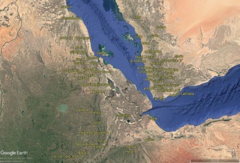
Mamluk–Ethiopian trade remains understudied, but textual and archaeological evidence allows a partial reconstruction of its main routes. From Cairo, traders travelled south along the Nile to Qus, crossed east to the Red Sea port of Quseer, and either continued by sea to Suakin, or proceeded on camelback via Aswan and Aydhab. From Suakin, routes led into Medri Bahri in the Eritrean Highlands, then onward to ʾAksum or to Kalghur near ʿAlīyu ʾAmba and Barārā near present-day Addis Ababa, with pack animals changing from camels to mules around Dese — because of frequent inundations, omnipresent mud, but more importantly, because of dangerous terrain known as Aheyyā Fağğ (the ‘Donkeys’ Death’), marked by narrow passes at about 2,500 metres altitude or higher.Footnote 65 Venetian travel manuals of the fifteenth and early sixteenth centuries—based on Alessandro Zorzi’s Ethiopian informants (1519–24)—estimate journeys of 84 to 89 days from Cairo to ʾAksum and 163 to 168 days to Barārā.Footnote 66 In addition to major commercial centres—most notably ʾAksum, Lālibalā, Gendebelo (near modern Nora), Harlaa, Barārā, and Kalghur—some two dozen smaller settlements, with their attached churches, functioned as international trade hubs and caravan stopovers (Figures 1–2).
Main Red Sea trade hubs c.1430. Éric Vallet, L’Arabie marchande. État et commerce sous les sultans Rasûlides du Yémen (626–858/1229–1454) (Publications de la Sorbonne, 2010), 744; O.G.S. Crawford, ed., Ethiopian Itineraries circa 1400–1524 (Cambridge University Press for the Hakluyt Society, 1958); G. Rex Smith, trans., A Traveller in Thirteenth-Century Arabia: Ibn al-Mujawir’s Tarikh al-Mustabsir (The Hakluyt Society, 2008), Maps 1 and 2.

Figure 1. Long description
The map illustrates the major Red Sea trade hubs around the year 1430. It highlights key locations such as Cairo, Qus, Quseer, Suakin, Aswan, Aydhab, Medri Bahri, ʾAksum, Dese, Barārā(near Addis Ababa) andKalghur (near near ʿAlīyu ʾAmba),.
Main trade hubs in the Yemen–Somalia–Ethiopia regions, c.1430. Éric Vallet, L’Arabie marchande. État et commerce sous les sultans Rasûlides du Yémen (626–858/1229–1454) (Publications de la Sorbonne, 2010), 744; O.G.S. Crawford, ed., Ethiopian Itineraries circa 1400–1524 (Cambridge University Press for the Hakluyt Society, 1958), passim; G. Rex Smith, trans., A Traveller in Thirteenth-Century Arabia: Ibn al-Mujawir’s Tarikh al-Mustabsir (London: The Hakluyt Society, 2008), Maps 1 and 2.
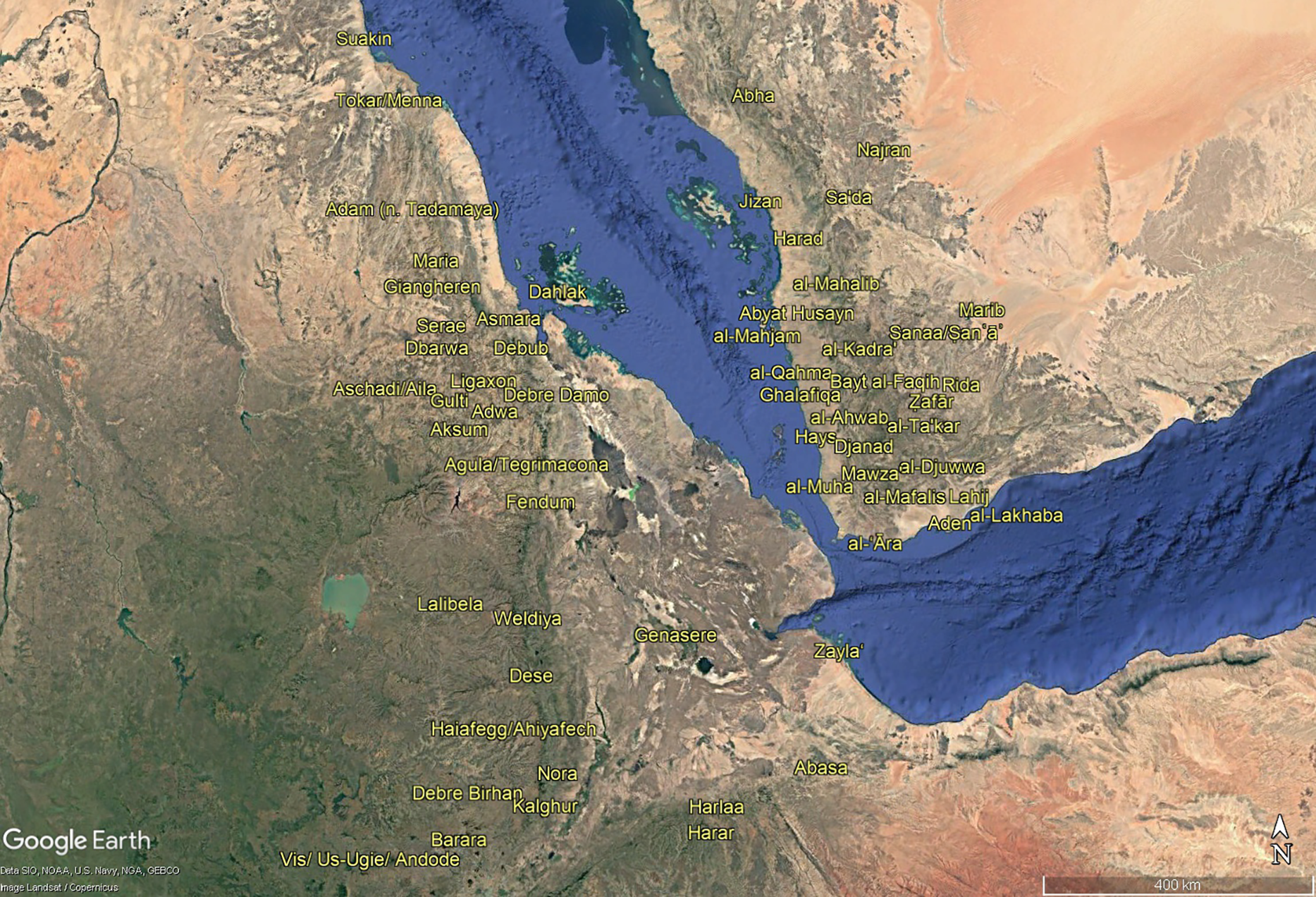
Figure 2. Long description
The map zooms in onto the primary trade routes and hubs in the Yemen-Somalia-Ethiopia regions circa 1430.
What goods were traded at these sites? Ethiopian traders supplied Egypt-bound merchants, first and foremost, with slaves, eunuchs, ivory, and gold; in addition, marine shells, textiles, cubeba peppers, gums, civet cats (and their musk), agarwood, wars plant for yellow dyeing, hides, and leather goods would be exported from local markets. In return, Mamluk merchants would supply local markets primarily with ceramics (including textile and bread stamps), glassware, silverware, silver coins, as well as gold-brocaded and woollen textiles, oil, and balsam.Footnote 67 These goods associated with Mamluk trade were unearthed, among other places, at Harlaa, a Muslim town abandoned c.1500.Footnote 68 At Lālibalā, local churchmen would use Middle Eastern salvers in the fourteenth and fifteenth centuries.Footnote 69 At Nora (identified with Gendebelo), and Ambā Gabriel (a Christian site in the Manz region of central Ethiopia, thriving in the fourteenth-sixteenth centuries), Mamluk-era Egyptian beads were unearthed.Footnote 70
Trade was only one form of interconnectivity between the two regions. Travellers included pilgrims (Christian and Muslim), scholars, clerics, and diplomats, with categories often overlapping. Ethiopian and Somali students at al-Azhar in Cairo were housed in the Zayāliʿa fraternity, while Christian Abyssinian and Nubian clerics—subject to the Coptic Patriarchate of Alexandria—travelled regularly between Ethiopia and Coptic ecclesiastical institutions in Egypt, as well as Alexandria and Cairo.Footnote 71 Some Christian pilgrims continued on to Sinai and Jerusalem, both home to Abyssinian communities in the fifteenth century, while Muslim scholars may have returned from the ḥajj via Cairo and Alexandria.Footnote 72 Diplomatic exchanges were infrequent but attested, with five known Solomonic embassies to the Mamluk sultanate in the fifteenth century (1412, 1437, 1443, 1453, and 1481).Footnote 73
The Ethiopian–Yemenite trade and travel system, c.1430
The impact of Red Sea trade on plague spread into Egypt at the onset of the Justinianic Plague in 541 has been hypothesised by Tsiamis et al. in 2009.Footnote 74 In the Rasūlid era, maritime traffic between Yemenite ports and the Somali coast was a daily activity, facilitated by a network of interconnected commercial hubs (Figures 1 and 2). On the northern coast of the Red Sea, the main ports were Aden and Zabīd, in addition to a series of at least nineteen more minor ports and anchorages.Footnote 75 On the southern coast, the three main ports were Zaylaʿ (Saylac in Somali), Berbera, and al-ʿĀra, in addition to a dozen of smaller hubs mentioned by Najm ad-dīn Aḥmad al-Ḥarrānī (c.1295), in an undated Rasūlid manual Nūr al-maʿārif, and by Aḥmad ibn Mājid (1490).Footnote 76 Between the coasts, the Dahlak Archipelago—a major slave-trade entrepôt—served as a coastal stopover linking the northern Solomonic empire with Zabīd.
Southbound Red Sea voyages, aided by the southern wind (al-azyab), typically ran from mid-October to late February, though Ibn Mājid extends the season to mid-May.Footnote 77 Ibn Baṭṭūṭa crossed from Aden to Zaylaʿ in four days in January 1331.Footnote 78 Northbound sailing, assisted by northern winds, usually occurred between March and early October, though favourable conditions could permit two-way crossings within a single season, as Ashraf ʿUmar II’s almanac (c.1271) indicates.Footnote 79 The Nūr al-maʿārif manual details Red Sea trade practices, including costs, fees, profits (c.30–40 per cent), and commodities.Footnote 80 Ethiopian exports to Yemen included gold, ivory, enslaved people, mules, sheep, civet cats, and hides, while Somali ports imported Indian cottons, silk, luxury textiles, and silver from Yemen.Footnote 81
Although most of Rasūlid–Ethiopian trade would be conducted at one of the Somali ports (predominantly, Zaylaʿ and Berbera) directly by Ethiopian or Yemeni merchants, or via Somali intermediaries, some dealings would take place in the Abyssinian interior or in Yemen proper. While some Yemeni merchants lived in Zaylaʿ and al-ʿĀra, it is possible that some resided, on a temporary basis, in Adal sultanate towns, enjoying privileges of their co-religionist patrons.Footnote 82 According to Francisco Álvares, sojourning in Abyssinia in 1520–26/7, the town of ‘Manadeley’ (in the Doba region of today’s Ethiopia) was an international trade centre, bringing together merchants from Arabia, Maghreb, India, Anatolia, and Greece.Footnote 83 Likewise, some Ethiopian merchants (both Muslim and Christians) would go all the way to Yemen to conduct their business: according to Shihāb al-Dīn’s Futūḥ al-Ḥabasha (c.1550–60), in c.1529 Solomonic emperor Dawit II sent Christian traders to Aden with various luxurious goods.Footnote 84
Based on interviews with Ethiopian priests in Venice (1519–24), Alessandro Zorzi described inland routes from Zaylaʿ to central Abyssinia. The first leg covered 230 km through the Danakil Desert from Zaylaʿ to Genasere (near Asayita) in twenty-five days on camelback. The second stretched 240 km from Genasere to Gendebelo (identified with modern Nora) in forty days through the western Danakil and the ‘cultivated land’ (campagne) of the Great Rift Valley. The final 55 km to Barārā (near Addis Ababa) took eight and a half days.Footnote 85 The total 630 km in seventy-three and a half days implies an average of 8.6 km/day—a very slow speed compared to 30–40 km a day achieved by Bactrian camels crossing the Ustyurt Plateau and Amu Darya valley in Central Asia in the 1330s, but, then again, the upland and highland terrain (and especially the Aheyyā Fağğ tract) meant that travellers had to proceed carefully.Footnote 86 Adding two days for the Berbera–Zaylaʿ crossing yields a complete journey time of some seventy-five and a half days. This information about travel speed is important for the discussion of plague spread mechanisms in the next section.
Once in Aden, the pandemic quickly spread north into Rasūlid territories, aided by local trade and communication networks. Unlike for Ethiopia, Yemen’s rich documentation allows reconstruction of the disease’s geographic spread. As elsewhere in the Islamicate world, travel relied on dromedary caravans, with camels carrying heavy loads six hours a day at about 3 miles per hour, and lighter loads up to 50 miles a day.Footnote 87 Yemen had several transregional routes: (1) Janad–Ṣaʿdah via Taʿizz and Sanaa (∼15 days); (2) the Tihāmah coastal route from Aden to Mecca via Zabīd and Jeddah, and inland via Taʿizz (∼1 month); (3) four eastbound roads to Hadhramaut; and (4) the Lahij route connecting Aden and Taʿizz.Footnote 88 Fourteenth- and early fifteenth-century Rasūlid rulers invested in renovating routes, establishing khans, waterpoints, and market villages, and attempted to contain Bedouin banditry.Footnote 89 While these measures facilitated trade and travel, they also created conditions for rapid pathogen spread across the region.
Yemeni goods are well represented in Ethiopian archaeological contexts. At Harlaa (an Islamic site in eastern Ethiopia, abandoned c. 1500), excavations yielded Yemeni glazed wares alongside Iranian lustre fritware and Chinese celadon.Footnote 90 At Ambā Gabriel (a Christian site in the Manz region of central Ethiopia of the fourteenth to sixteenth centuries), Hadhramaut glass tableware appears.Footnote 91 By contrast, no Yemeni goods have been found at Nora (Gendebelo), thriving from the late thirteenth to the early sixteenth century.Footnote 92
Besides merchants, Islamic scholars, mystics, and annual ḥajj pilgrims also crossed the Red Sea, though the latter’s role in plague spread should not be overstated. Apart from the Black Death reaching Mecca in 749 ah (1348–49), most likely during the ḥajj (February–March 1349), documented outbreaks in the later Mamluk period occurred in Shaʿbān 792 ah (mid-July–mid-August 1390), Dhū al-Ḥijja 827 ah (November 1423), Shaʿbān and Ramaḍān 837 ah (March–May 1434), Shaʿbān–Ramaḍān 843 ah (January–February 1440, reported generally in Hejaz), and at the end of 881 ah/beginning of 882 ah (spring 1477), with only the last explicitly termed ṭāʿūn.Footnote 93 Of these, only the 827 ah and 881–82 ah outbreaks coincided with the ḥajj. Yemenite scholars resided in the Adal sultanate, and Muslim Ethiopians stayed in Yemen—for example, the Sufi ʿAlī b. ʿUmar al-Shāḏilī (d. 828 ah/1424–25), linked to al-Mukhā and the introduction of coffee, spent years at the Adal court.Footnote 94 Fourteenth-century Solomonic embassies to the Rasūlids were rare, and none are recorded in the fifteenth century.Footnote 95
Plague spread through the Red Sea trade and travel system, c.1430–38
Based on Red Sea trade routes, we can hypothesise how plague first reached Ethiopia, then the Somali coast and Yemen. Direct travel took 84 to 89 days from Cairo to ʾAksum, 163 to 168 days to Barārā, and 78 to 80 days from Aden via Zaylaʿ or Berbera to Barārā, likely longer with breaks. Yersinia pestis would thus need to survive in goods or personal items for several months without triggering human outbreaks during transit.
A recent study on plague spread from the Tian Shan to the Caspian in the 1340s suggests that Yersinia pestis could survive in ‘very short-term’ transient reservoirs, such as grain sacks, textiles, or rugs, where fleas could persist for months, transmitting bacteria to new fleas.Footnote 96 Textiles were widely traded—Egyptian wool and gold-brocaded fabrics to Ethiopia, Yemeni cotton to Ethiopia, and Ethiopian textiles to Egypt and Yemen. Conversely, there is no evidence of long-distance grain trade between Egypt and Yemen, on the one hand, and the Horn of Africa, on the other. Egyptian and Yemeni wheat was exported to Hejaz, but not into Ethiopia.Footnote 97 Local and regional Ethiopian grain trade, especially in teff, barley, and wheat produced in the highlands, may have aided plague spread through marketplaces and exchanges with pastoral arid lowlands.Footnote 98
While some plague hosts—gerbils, jerboas, and ground squirrels—tend to avoid human settlements, others—mice and rats, both commensal and sylvatic, often live near communities searching for crop fodder. Agriculture was central to both Ethiopian and Yemeni economies. In Yemen, local qabā ʾil (tribal farmers) cultivated wheat (highlands and Mikhlāf Jaʿfar), sorghum (two to three harvests per year, highlands and Tihāmah coastal plain), millet (Tihāmah, sown in June, harvested in October), legumes (widely), rice (Wadi Zabīd), and cotton (coastal Tihāmah, Lahij, Abyan).Footnote 99 In the Ethiopian highlands, wheat, sorghum, teff, and legumes were widespread, barley grew in the highest Christian plateau,Footnote 100 and cotton was common, including in Gojjam (paying the royal tribute of 3,000 mules, 3,000 horses, 3,000 cotton garments, as noted by Álvares) and the (still largely pagan) southern provinces (rendering the tribute in gold, horses, cotton under negus Yesḥaq I, 1414–29/30).Footnote 101 Arid lowlands, by contrast, focused on pastoralism and arboriculture.Footnote 102
Crop storage was another crucial economic factor. In Yemen, harvested grains and cotton bales were kept in village barns, larger market-town warehouses, and Red Sea ports (mainly for export to Hejaz), always facing the north wind to prevent spoilage.Footnote 103 Stored grains and cotton could facilitate plague spillover from sylvatic and commensal rodents to humans.Footnote 104 Information on Abyssinian storage is patchier: Zorzi noted storehouses at Gendebelo and Barārā and described the Barārā and Us-Ugie (near Andode) regions as ‘one warehouse and a country of storehouses’.Footnote 105 Country barns are harder to trace, but some highland rock-hewn monuments likely served as granaries in addition to houses, churches, or burial chambers.Footnote 106 In arid eastern Ethiopia and lowland Yemen, crops were often stored in underground pits, a method still used today.Footnote 107
Once harvested, crop surpluses—beyond seed and household consumption—were transported to local rural and urban markets as seeds or bales. In Yemen, the diversity of crops and ecological differences between lowlands and highlands meant that harvests occurred nearly every month, making crop transport a constant feature. Since rodents and their fleas often inhabit crops and textiles, plague could travel from villages near reservoirs to distant settlements year-round, causing human outbreaks. This was aided by the fact that, except for the lesser Egyptian jerboa, local sylvatic rodents did not hibernate. This was unlike Europe, where annual summer harvests created a narrower window for plague to spread from reservoirs to surrounding areas, as evidence from South Germany shows.Footnote 108
Like Yemen, Ethiopia lacked wheeled transport; goods moved via camel caravans in the lowlands and donkey trains in the Rift Valley and highlands. Donkeys do not carry plague, but camels can.Footnote 109 For months-long journeys, camels had to remain plague-free until near the end, that is, approaching the Somali coast from Abyssinia to Zaylaʿ or Berbera. In theory, infected camels could die mid-journey and be replaced, but this would slow plague spread. Humans—merchants, pilgrims, or enslaved people—could also carry Yersinia pestis via fleas and lice. Ibn Baṭṭuṭa noted camels and fat barābir sheep reared from the Danakil desert to Mogadishu.Footnote 110 Sheep, though less susceptible than camels, could also carry plague. In the Red Sea region—much as in other parts of the world—rodent colonies are often clustered near livestock-grazed pastures, avoiding dry, nutrient-poor grasslands.Footnote 111 As some sources state, barābir sheep were transported from Zaylaʿ to Aden and then inland into Yemen.Footnote 112
Somali coastal towns like Berbera and Zaylaʿ may have aided human plague spread. Al-Ḥarrānī described Zaylaʿ as very populous, while Ibn Baṭṭuṭa called it as a filthy city due to fish consumption and camel slaughter.Footnote 113 Rats and mice thrive near slaughterhouses, providing a potential short-term plague reservoir,Footnote 114 and camels themselves could carry the disease, with meat processing offering a transmission route.Footnote 115 Abū Ḥāmid al-Gharnātī (c.1162) noted that Zaylaʿ inhabitants ate dogs and rats, which they preferred to sheep.Footnote 116 If true in the early fifteenth century, rat meat processing could have further facilitated plague transmission locally and across the sea.
The eco-climatic context of plague focalisation in the Red Sea region in the 1430s
The previous sections have shown how trade and travel mechanisms linking the Red Sea region may have functioned as very short-term ‘transient’ reservoirs, harbouring plague bacteria in goods and animals for weeks or months. Once introduced into interior Abyssinia and Rasūlid Yemen, plague could spill over into human communities, spread widely, and—more decisively—become established in medium-term reservoirs in the highlands, possibly around Lake Tana (Ethiopia) and in the Ibb region (Yemen). Such transient reservoirs, and their interaction with longer-term endemic foci, remain poorly studied. To understand how plague focalised in Highland Yemen and possibly Abyssinia (around Lake Tana) in the 1430s, the ecological and climatic contexts of these regions must be considered.
In the early fifteenth century, the vegetation and wildlife landscapes of the Great Rift Valley and the northern Ethiopian highlands differed markedly from today. According to Alessandro Zorzi and Francisco Álvares in the 1520s, these regions were covered by extensive, dense woodlands sheltering elephants, with villages nearby.Footnote 117 In subsequent centuries, however, the area underwent progressive deforestation.Footnote 118 Álvares already noted tree burning for agriculture and road expansion in the 1520s; Manoel de Almeida (1624–33) observed widespread tree scarcity due to systematic cutting; and James Bruce (1770–71) later lamented the severe lack of woodland, especially around Gondar and Lake Tana.Footnote 119
The Yemenite Highlands likewise appear to have been more forested in the fifteenth century than later. Ibn al-Mujāwir, travelling there in the early thirteenth century, described parts of the highlands as impenetrable due to dense evergreen and deciduous forests, including Trichilia emetica, tamarind, and acacia, noting that these forests supplied timber to other regions of Yemen.Footnote 120 More than three centuries earlier, Abū Ḥanīfah al-Dīnawarī (d. 895), in his Kitāb al-Nabāt, mentioned additional trees—such as cashew and walnut—growing in Yemen’s mountains and wadis.Footnote 121 By contrast, when Carsten Niebuhr travelled through the highlands in June–July 1763, he observed a marked scarcity of trees, despite the continued presence of shrubs and other vegetation.Footnote 122
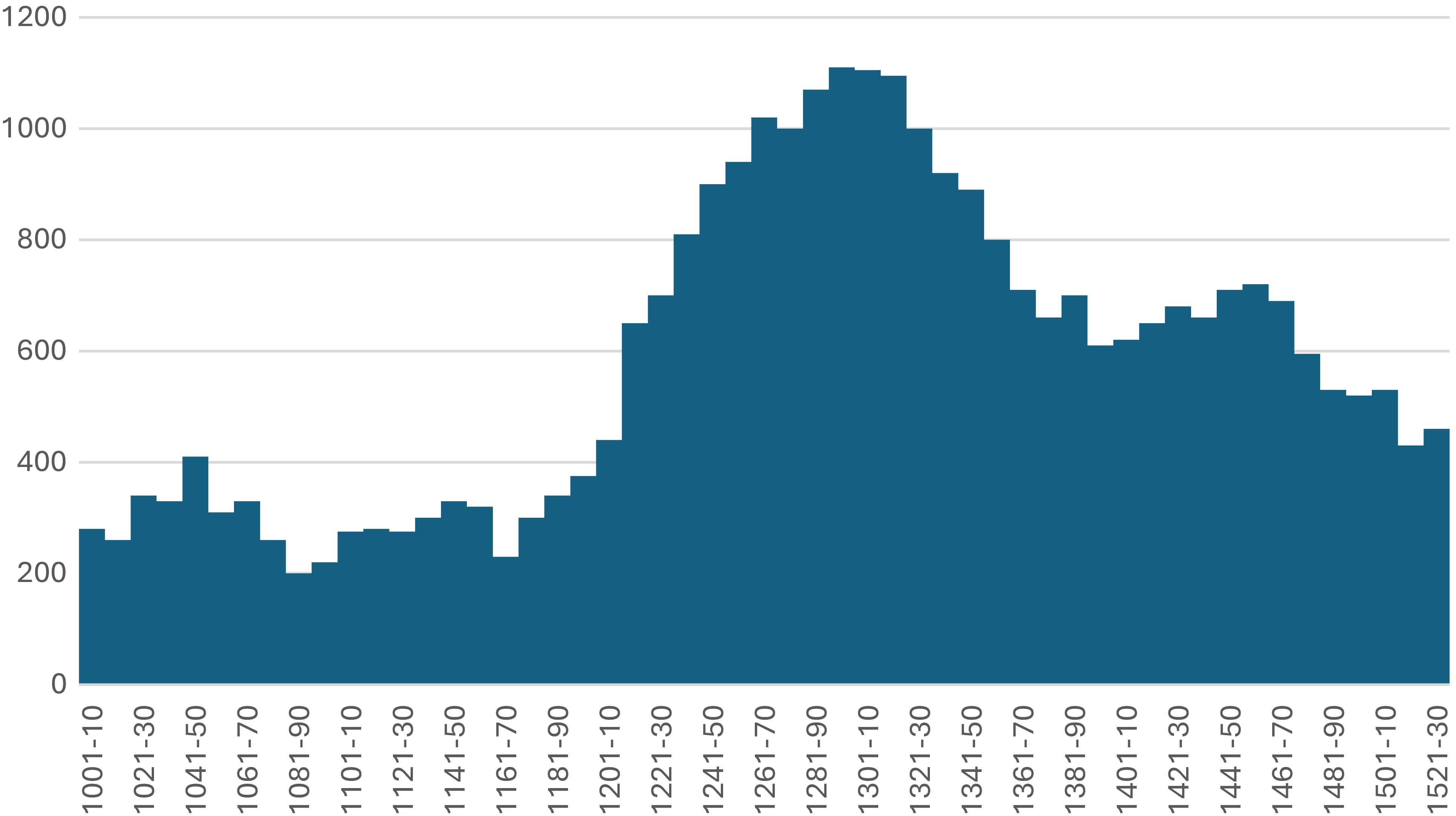
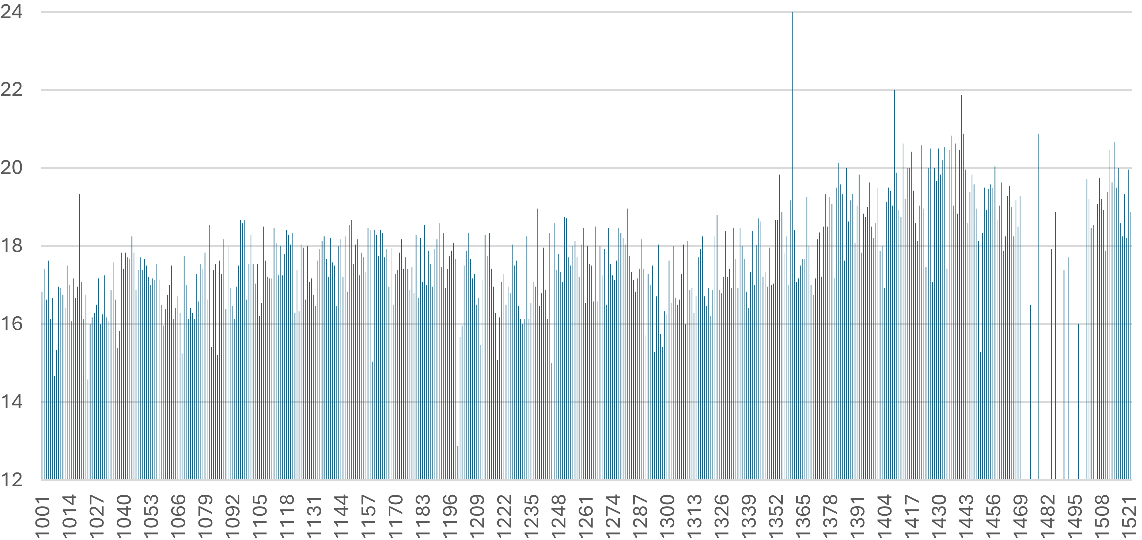
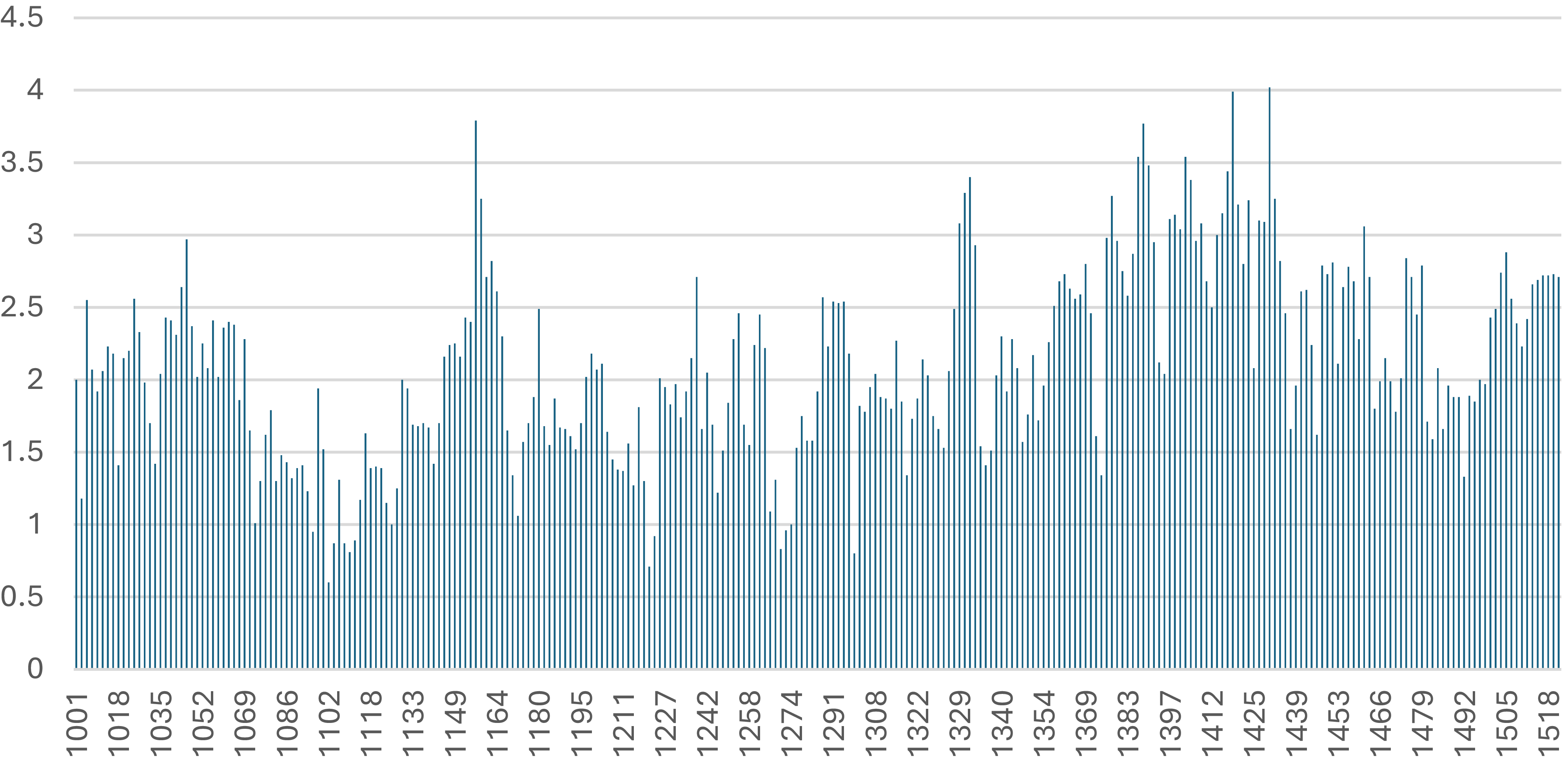
Focusing on the early fifteenth-century climatic context of the southern Red Sea region, proxy evidence points to unusually wet conditions. Sedimentary carbonate records from Lake Hayq (northern Ethiopia; Figure 3) show that Indian Ocean monsoon intensity rose sharply in the thirteenth century, peaking in c.1290–1320, declined c.1320–80, then increased again and remained relatively high until c.1470, before falling thereafter. This pattern is corroborated by summer–autumn Rhoda Island nilometre readings from Old Cairo (Figure 4) and winter–spring stalagmite data from Hoti Cave in northern Oman (Figure 5), both indicating exceptionally wet conditions between c.1376 and c.1440 (c.1432 in Oman and c.1447 for the Nile). These were the wettest intervals on record for the Nile for the period 1001–1522 (there are, unfortunately, only forty-two annual nilometre recordings between 1523 and 1698, hence c.1522 is the upper chronological boundary for all three climatic series here) and for Hoti Cave, for the same period. Although the nilometre lay over 2,000 km north of the putative Ethiopian plague reservoir, its readings reflect conditions in the Ethiopian highlands, since intensified summer monsoons flooded the Blue Nile and Atbara River, raising Nile levels during the annual inundation from early June to mid-October.Footnote 123 High post–Black Death Nile floods, however, also reflected rising riverbed height and—most importantly—failures in canal and basin maintenance in Upper Egypt, caused by plague-related labour shortages and Bedouin attacks, which prevented excess floodwaters from being properly absorbed.Footnote 124
Decennial averages of Indian Ocean monsoon activity reflected in precipitation levels around Lake Hayq (in northern Ethiopia) deriving from sedimentary carbonate record (in inverted δ18O (oxygen) values), 1001–1530. Henry F. Lamb et al., ‘Oxygen and Carbon Isotope Composition of Authigenic Carbonate from an Ethiopian Lake: A Climate Record of the Last 2000 Years’, The Holocene 17, no. 4 (2007): 517–26.
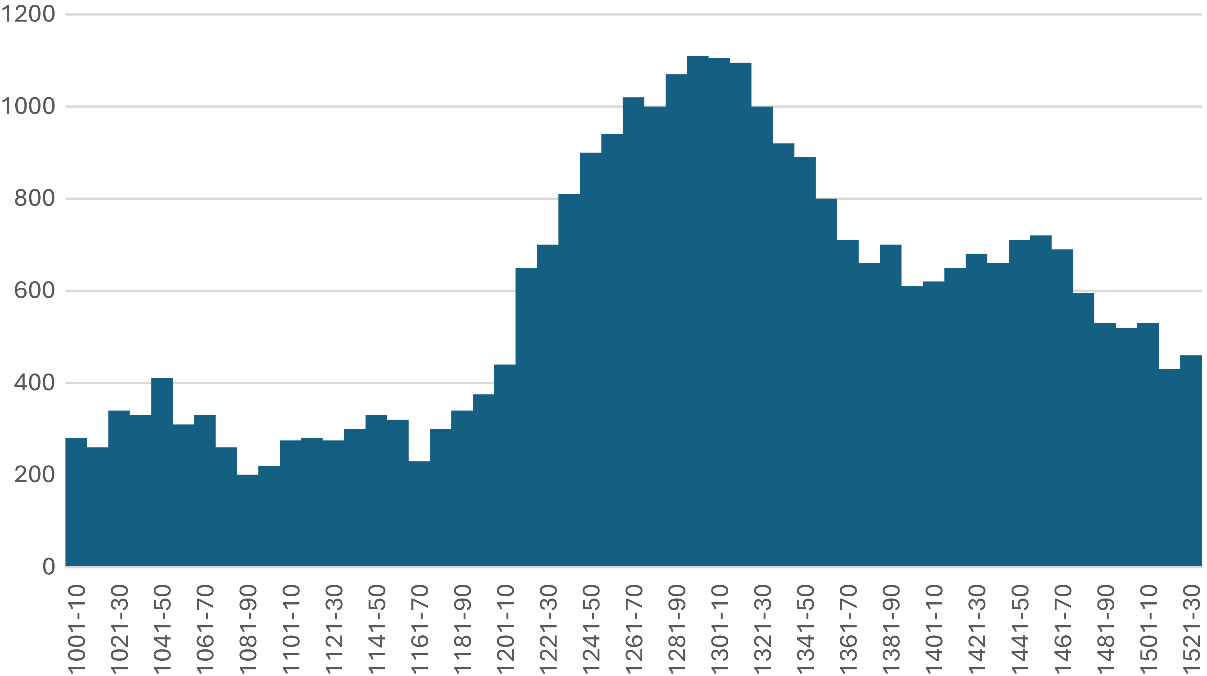
Figure 3. Long description
The histogram displays decennial averages of Indian Ocean monsoon activity reflected in precipitation levels around Lake Hayq in northern Ethiopia from 1001 to 1530. The x-axis represents the time intervals in decades. The y-axis represents the precipitation levels.
Annual Nile flooding levels, 1001–1522 (in pre-Ottoman-style cubits; max=24). Omar Toussoun, Mémoire sur l’histoire du Nil, vol. 2 (Imprimerie de l’Institut français d’archéologie orientale, 1925), 361–93; Sāmī Amīn Pāshā, Taqwīm al-Nīl (Al-Maṭbaʿah al-Amīrīyah, 1916), 17–21; William Popper, The Cairo Nilometer: Studies in Ibn Taghrî Birdî’s Chronicles of Egypt (University of California Press, 1951); Otto F.A. Meinardus, ‘Nilometer Readings According to a 13th Century Coptic Source’, Oriens Christianus 62 (1978): 169–95; Al-Maqrīzī, Kitāb al-sulūk li-maʿrifat duwal al-mulūk, ed. S.ʿA.F. ʿĀshūr (Matbaʿat Dar al-Kutub, 1973), vols. 2.1–4.3.
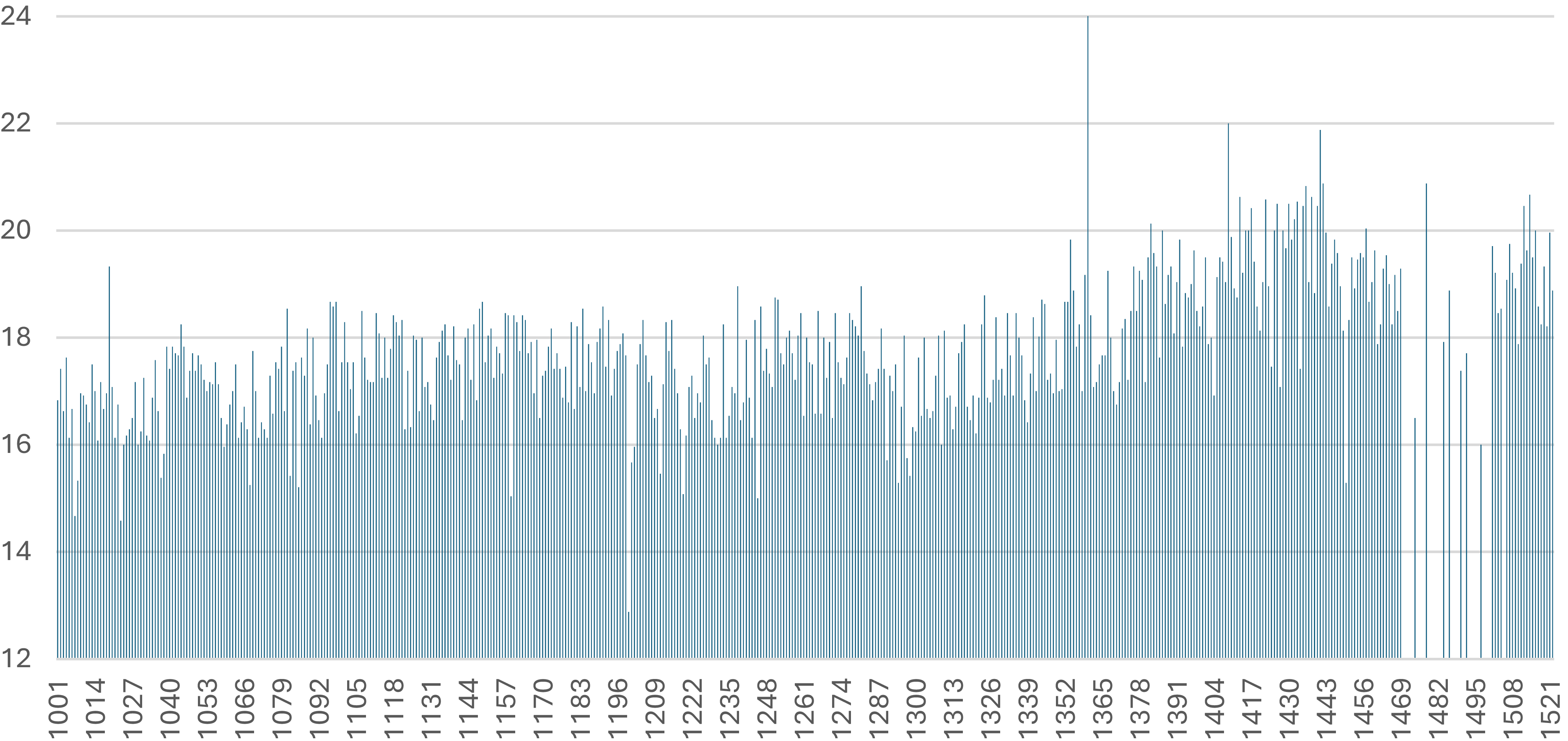
Figure 4. Long description
The line graph illustrates the annual Nile flooding levels from the year 1001 to 1522, measured in pre-Ottoman-style cubits. The x-axis represents the years, ranging from 1001 to 1522, while the y-axis indicates the flooding levels, with a maximum value of 24 cubits.
Winter–spring precipitation levels deriving from Hoti Cave (northern Oman) stalagmite record (in inverted δ18O (oxygen) values), 1001–1522. Dominik Fleitmann et al., ‘Droughts and Societal Change: The Environmental Context for the Emergence of Islam in Late Antique Arabia’, Science 376 (2022): SI.
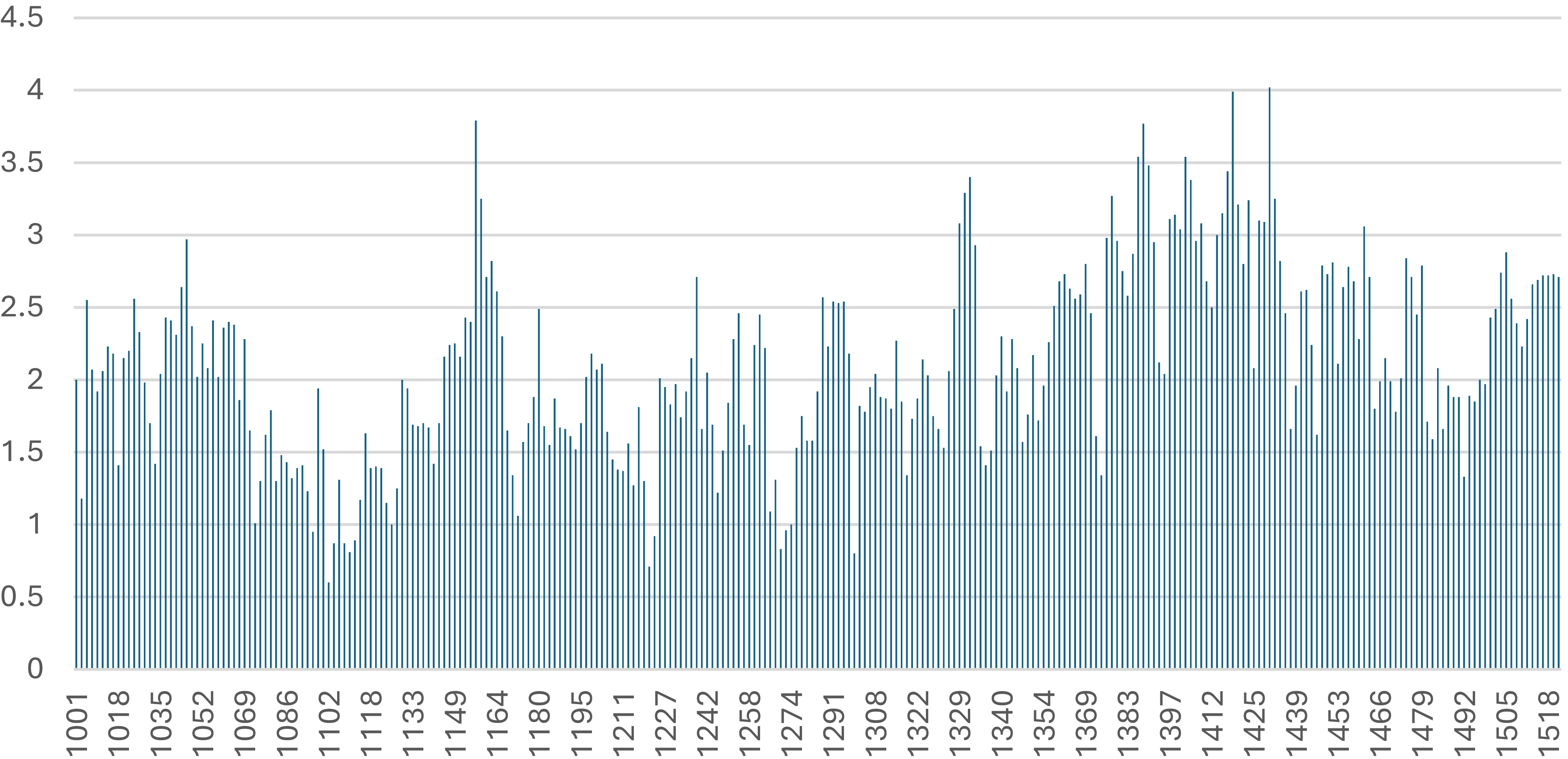
Figure 5. Long description
The line graph illustrates winter-spring precipitation levels derived from a stalagmite record in Hoti Cave, northern Oman, using inverted delta 18O values. The x-axis represents the years from 1001 to 1522, while the y-axis indicates the precipitation levels.
Importantly, rainfall regimes differ across the Arabian Peninsula: northern Oman and most of Arabia depend on Mediterranean frontal systems, whereas summer monsoon precipitation is largely confined to the Yemeni highlands and southern Oman.Footnote 125 For this reason, Hoti Cave data cannot serve as a direct palaeoclimatic proxy for the Yemeni Highlands. Nevertheless, comparison of the Lake Hayq record and annual nilometre values with Hoti Cave stalagmite data reveals a striking synchronicity (Figures 3–5). Dry spells in the later eleventh and thirteenth centuries appear in both the nilometre and Hoti Cave series; wet conditions c.1280–1460 are reflected in both the Hayq and Hoti records; and the pronounced wet phase of the later fourteenth and early fifteenth centuries stands out clearly in all three. Although the drivers of this convergence between distinct climatic regimes remain unclear, the Hoti Cave record may be cautiously employed as an indirect proxy for conditions in the Yemeni Highlands.
Extreme flooding is well attested in textual sources. Between 1377 and 1450, torrential rains were recorded on at least twenty-nine occasions in Lower Egypt, on ten occasions in the Hejaz and on eleven occasions in Yemen.Footnote 126 Comparable Ethiopian data are lacking, but the eco-climatic linkage between Egypt and Ethiopia allows the use of very high Nile floods (≥19 cubits) recorded by the Rhoda nilometre on forty-six occasions between 1376 and 1447 as an indirect proxy for excessive Ethiopian monsoon rainfall (keeping in mind also the failure of local canals and basins in Egypt), corroborated by Lake Hayq data for c.1380–1470 (Figures 3–4).Footnote 127 It was against this background that negus Zarʿa Yāʿeqob (r. 1434–68) sent his 1443 letter to Sultan Jaqmaq (r. 1438–53), threatening to divert the Nile in response to the persecution of Coptic Christians in Mamluk lands.Footnote 128
Some 260 years of elevated Indian Ocean monsoon precipitation, indicated by Lake Hayq sediments (c.1210–1470), together with a shorter wet phase in the Hoti Cave record (c.1280–1460), and an even briefer period of sustained wet conditions in the nilometre data (c.1376–c.1440), profoundly affected highland ecologies in Yemen and Ethiopia. These conditions likely promoted the expansion of woodland and pasture vegetation. In the Ethiopian highlands, torrential rains—common during and beyond the kremt season (June–mid-September)—caused frequent flooding and disrupted travel, as noted by Zorzi and Álvares.Footnote 129 But rainfall during these centuries must have been exceptionally intense, generating abundant grass. Such vegetation surpluses are closely linked to the proliferation of sylvatic rodents, including species capable of acting as plague reservoirs.
Both the Yemeni and Ethiopian highlands hosted numerous potential plague-carrying rodents and their ectoparasites. In Yemen, these included five Muridae species (Cairo spiny mouse, African grass rat, Balochistan gerbil, House mouse and Black rat), the lesser Egyptian jerboa, and the Cape hare.Footnote 130 The Ethiopian highlands supported even greater diversity: some sixteen Muridae species (mice, rats, gerbils and Mylomys), three Nesomyidae mice, the African Hammada jerboa, dormice, and the African striped ground squirrel.Footnote 131 Wild rodents and ectoparasites also appear in historical accounts: Carsten Niebuhr (June–July 1763) noted hares and jerboas in the Yemeni highlands, while James Bruce (1770–72) described swarms of mice, rats, and insects threatening agriculture in the Gondar region.Footnote 132 Given that both regions were far more densely wooded in the fifteenth century than in later periods, rodent populations were likely higher. Combined with the exceptionally wet phase of the 1370s–1440s, this would have favoured increases in both rodent hosts and their ectoparasites, whose densities are closely correlated with plague activity.Footnote 133 Humid conditions further promote ectoparasite hatching and survival, making the eco-climatic setting of the wider Red Sea region in the 1370s–1440s particularly conducive to plague persistence and focalisation in the Yemeni and Abyssinian highlands.
Once Yersinia pestis penetrated the Abyssinian interior and Rasūlid territories, it appears to have focalised in local ecologies. On the basis of historical evidence, a recent study has reconstructed a Yemeni plague reservoir located in the highlands—possibly in the Ibb region—active c.1436–1557/58, after which it abated (see SI and SI Tables).Footnote 134 The Ethiopian reservoir generated recurrent outbreaks until 1634/35, after which Ethiopian sources do not mention this disease. Its precise location remains uncertain due to limited evidence, but early seventeenth-century outbreaks suggest a focus in the Lake Tana area, possibly in Gojjam or the Dambeyā region (see SI). If this reconstruction is broadly correct, then these highland reservoirs functioned as medium-term foci, persisting for roughly 125 years in Yemen and about 200 years in Ethiopia. While the environmental factors sustaining the Yemeni reservoir have been recently studied, those of the Ethiopian highlands remain entirely unexplored.Footnote 135
The analysis above indicates that plague’s arrival, focalisation, and recurrent outbreaks in the southern Red Sea region were triggered by distinctive eco-climatic conditions. As sedimentary evidence from Lake Hayq indicates, this process was preceded by approximately 260 years of elevated Indian Ocean monsoon precipitation. The period c.1376–1440 was characterised by exceptionally wet conditions, as reflected in both the Hoti Cave stalagmite record (Oman) and the Rhoda Island nilometre. In the latter case, however, high flood levels also resulted in part from the failure of Nile canals and flood basins to absorb excess water, following post–Black Death depopulation and recurrent Bedouin attacks.
In broad terms, these conditions translated into many decades of sustained vegetation growth, such that on the eve of the initial plague introduction in the 1430s, pastoral and sylvatic vegetation must have been unusually abundant. Woodland landscapes in both the Ethiopian and Yemeni highlands—prior to later phases of deforestation—were considerably denser than in subsequent centuries. Extensive woodland and pasture would have promoted the growth and high densities of wild rodent populations and their ectoparasites, serving respectively as potential hosts and vectors of plague bacteria, and thereby creating optimal conditions for plague focalisation. This once again underscores the importance of eco-climatic factors in shaping plague activity, a point repeatedly emphasised in recent historical scholarship.Footnote 136
Conclusions
For some scholars, recurrent outbreaks in Afro-Eurasia during the Second Plague Pandemic are understood as repeated reintroductions from Asia.Footnote 137 In recent years, however, both historians and ancient DNA researchers have increasingly recognised the likelihood of endogenous plague reservoirs in other regions, including in south-central Germany.Footnote 138 More recently still, the ecology of a Yemeni plague reservoir has been examined,Footnote 139 and a case has been made for the focalisation of plague around Lake Victoria c.1700.Footnote 140 By contrast, plague focalisation in Ethiopia during the pre-modern period has received no scholarly attention. The present article therefore adds Ethiopia to the global map of natural plague reservoirs.
This body of new evidence naturally raises a series of further questions that lie beyond the scope of the present article. What was the spatio-temporal reach of the recurrent plague waves emanating from these newly identified reservoirs? Were they confined to Abyssinia and Yemen, or did they extend further, for example into the Arabian Desert, Egypt, and northwards into the Middle East? What factors enabled the long-term persistence of these reservoirs, and what triggered the periodic re-emergence of plague—eco-climatic conditions, anthropogenic activity, or some combination of the two? Under what circumstances did these reservoirs ultimately decline and disappear in the sixteenth and seventeenth centuries? More specifically, what role, if any, did deforestation play in the contraction and eventual extinction of highland plague reservoirs? This final question intersects with broader and ongoing debates concerning the relationship between ecology and infectious diseases, particularly those centred on the zoonotic origins of epidemic pathogens.Footnote 141
There are additional ‘big’ questions that pertain to the longue durée history of the Red Sea region. For example, what effects did recurrent plague waves—and the associated demographic decline and stagnation—have on the socio-economic structures of Abyssinia and Yemen? A substantial body of scholarship has argued for the role of plague in driving long-term economic decline in the late medieval and early modern Middle East, yet Yemen, as a perceived ‘periphery’ of the Islamic world, has been largely excluded from these discussions. Similarly, Ethiopia has not been integrated into this growing body of work. Expanding the geographic scope in this way has considerable potential to enrich ongoing debates about the origins, character, and chronology of the so-called ‘Great Divergence’ between the ‘West’ and the ‘Rest’.Footnote 142
This last point is closely connected to the quasi-global character of plague history in general, and of the Second Plague Pandemic in particular. As demonstrated above, before focalising in the Ethiopian and Yemeni highlands, the plague wave under discussion undertook a long trajectory from its point of origin somewhere in northern Eurasia—possibly the Pontic–Caspian steppe—moving through the Caucasus, Anatolia, Syria, Palestine, and Egypt into Abyssinia, and subsequently via the Somali coast into Yemen. The scope of the present article does not permit a comprehensive analysis of this entire trajectory; nonetheless, in order to understand how plague reached Ethiopia and Yemen in the first place, it was essential to situate the discussion within the broader Red Sea world, incorporating Egypt and the Somali coast. A focus restricted to Yemen, to Ethiopia, or even to both regions together—without reference to this wider context—would have produced only partial conclusions and left key questions unresolved. This, once again, underscores the necessity of embedding any study of plague history, whether regional or transregional, within a much broader geographical framework.Footnote 143
Lastly, the present article underscores another key scholarly imperative: the need to adopt an inherently multidisciplinary approach to the study of plague history. For all their undeniable strengths, textual sources have clear informational limits and are at times sparse or altogether absent. To address that, these were supplemented with both archaeological findings and palaeoclimatic data. Ideally, aDNA of plague bacteria is to be integrated into the analysis, but there is no aDNA from these regions (the closest thing is a single isolate from a 1969 outbreak in the Ḫawlān region of Yemen, discussed in SI). Currently, obtaining additional aDNA from local contexts in Yemen and the Somali coast is impossible due to ongoing conflicts, insecurity, and corruption, which hinder scientific research. One can only hope—perhaps naïvely—that conditions will improve in the future, allowing aDNA to be recovered from archaeological sites in the southern Red Sea region.Footnote 144 Such findings would be invaluable, not only for studying the history of plague, but also for tracing the global evolution and dissemination of Yersinia pestis strains during the Second Plague Pandemic. Importantly, the environmental conditions of the Yemeni and Ethiopian highlands are more favourable for aDNA preservation than the hotter, excessively arid, or overly humid areas elsewhere in the Arabian Peninsula, the Somali coast, and the Ethiopian lowlands.
Only through such an interdisciplinary approach—integrating multiple forms of evidence and deploying diverse methodological perspectives—can we begin to make sense of phenomena as complex as epidemic diseases, plague included. A deeper, historically based understanding of pandemics, past and present, grounded in this interdisciplinary vision, will ultimately place us in a stronger position to comprehend and confront those of the future.
Supplementary material
The supplementary material (including tables) for this article can be found at https://doi.org/10.1017/S1740022826100539
Acknowledgements
I am grateful to Stuart Borsch (Assumption University) and Kate Pukhovaia (Utrecht University) for their kind help with sources.
Financial support
This work is funded by the ERC/UKRI Project ‘SYNERGY PLAGUE: Reconstructing the environmental and societal drivers of plague outbreaks in Eurasia between 1300 and 1900’.
Competing interests
The author declares none.
Philip Slavin is a professor of medieval and environmental history at the University of Stirling and an author of over sixty publications on various topics related to environmental, economic, and social history of late medieval Eurasia, with a particular focus on ecological and biological crises. He is currently working on various papers dealing with global plague ecologies and their connections to wider biological, demographic and socio-economic processes.



 Open access

