

The Down Survey was a cadastral and topographic survey, launched in 1655 during the Cromwellian colonization of Ireland. Managed by William Petty, it was executed to redistribute lands confiscated from Irish rebels, as defined in the 1652 Act for the Setling of Ireland. In Petty's words, the survey described and mapped the parishes and baronies, along with the farmland, ‘townes, Castles, bridges, churches, loughs, boggs, mountains, rivers, highways’ situated in them.Footnote 1 Initially it was limited to areas designated to satisfy the debentures of Cromwell's soldiers and officers but was extended in 1656 to lands owed to ‘adventurers’ – merchants whose loans financed the English military expedition.Footnote 2 While the fieldwork itself was completed in 1657, Petty was also charged with allotting the surveyed parcels to soldiers, a process lasting until 1659. The survey roughly covered all provinces save for Connacht, which was reserved for ‘transplanting’ the dispossessed Irish.Footnote 3
Petty is today predominantly renowned as a pioneer of politico-economic and, alongside his colleague John Graunt, demographic and statistical analysis. In some attempts to read Petty as the precursor of modern scientific disciplines, the Down Survey is ignored altogether.Footnote 4 In other cases it is mentioned as a major influence on Petty's later life and work, but such remarks are often general and largely separate his management of the Down Survey from his better-known theoretical oeuvre. The survey is hence repeatedly acknowledged as the source of Petty's wealth and noble status, as the overarching social context in which he worked, or as an early experience on which he drew in his subsequent political programmes for Ireland. Yet it is rarely ascribed any substantial influence on concrete notions or methods in his ‘mature’ thought.Footnote 5 The tendency to disconnect Petty's statistical concepts from the Down Survey is particularly explicit in Ian Hacking's proposal that historiography of statistics should focus on radical transformations of ideas and on intellectuals who first grasped the special nature of population phenomena, like ‘normal mortality’. Accordingly, he embraces the portrayal of Petty and Graunt as ‘Columbuses’ who were capable of viewing and using already existing data differently. Hacking briefly mentions the Down Survey but largely disconnects it from Petty's later intellectual ‘mutation’.Footnote 6 Petty's scientific conquests are thus safely detached from his involvement in the conquest of Ireland. Even researchers not subscribing to Hacking's model of historiography, who have accurately emphasized the impact of English colonialism on Petty's writings, have mainly treated the survey as a general background to his later ideas.Footnote 7
Several studies have, nevertheless, accorded the survey a more prominent role in Petty's intellectual biography.Footnote 8 Building on these contributions, this paper re-examines the Down Survey to show how Petty's statistical and politico-economic work related both to his colonial employment in Ireland and to the ‘scientific knowledge’ of his time. It argues that Petty first arrived at the possibility of seeing and analysing a territory as an aggregate of natural and politico-economic data because of the techniques he adopted from natural history to manage the Down Survey. Historians generally acknowledge Petty's survey as a more ambitious continuation of antecedent attempts to draw up natural-historical and geographical descriptions of Ireland.Footnote 9 However, the survey did not merely gather the same sort of information as did contemporary natural-historical expeditions; Petty went beyond this, and treated the survey itself as an object of natural-historical investigation. Following Bacon, the history of trades or the systematic description of crafts had become a privileged sub-domain of natural history. Petty managed the Down Survey as a historian of trade, using natural history as a method for disciplining the art of land measurement. Furthermore, alongside management strategies derived from histories of trades, he also borrowed from natural history the use of standard forms, particularly the questionnaire, to collect and organize information. Petty employed such forms to calibrate the perception of his specialized workers and standardize their reports on Irish territory.Footnote 10
Besides reframing Petty's intellectual development, this reinterpretation also highlights the neglected influence of natural history on the development of statistics. To demonstrate this, I compare Petty's management of the Down Survey with Graunt's handling of the London bills of mortality. I believe that both Petty and Graunt can be taken as indicative of a distinct style of natural history, aimed at surveying the ‘state of a country’, which I call territorial natural history because of its focus on recording the features of a bounded administrative region. Barbara Shapiro and Alix Cooper have recognized the existence of a similar tradition of territorial surveys in Britain and continental Europe, but not its connection to Petty or the emergence of statistics.Footnote 11 The terms ‘tradition’ and ‘style’ do not imply a strictly bounded field of knowledge, since no consistent distinction separates territorial natural history from other denominations used for territorial descriptions in this period (‘geography’, ‘chorography’, ‘topography’, and – in certain contexts – ‘cosmography’).Footnote 12 Nevertheless, territorial natural history can be understood as a tradition in the sense of an identifiable community of researchers sharing characteristic methods, manners of thinking and referential authors. Because of their aim to survey a circumscribed territory, and the techniques applied to gather information, practitioners in this tradition introduced subtle, yet decisive, departures from both classical and Renaissance natural histories and also from Bacon's version of natural history – although they continued to invoke him as a flagship philosopher.Footnote 13 Their territorial approach can also be distinguished from a delocalized, ‘global’ natural history, pursued by contemporaries like Robert Boyle and John Locke. The paper closes by exploring the spread of territorial natural history in the seventeenth and eighteenth centuries, identifying a continuity between this tradition and the appearance of statistics in the British Isles. By tracing the link between the Down Survey, territorial natural history and statistical inquiry, I offer an alternative model for the history of statistics, not as a genealogy of probability theories and epistemic breaks, but as a history of practices involved in the accumulation and ordering of data.
History as a repository
It was with Bacon that history of trades became a central branch of natural history. Bacon did not understand history in a strictly temporal sense, but rather as a ‘repository’ of meticulously reported facts, past or present, purged of philosophical conjectures. He reckoned that the study of the work materials and operations of different trades and crafts was a particularly valuable source of natural-historical record because artisans mould and manipulate nature, thus potentially revealing otherwise inconspicuous phenomena.Footnote 14
Following Bacon's natural-historical programme, an informal circle of correspondents gathered around the patron and intelligencer Samuel Hartlib, and started to study various trades and arts not only with the aim of gathering useful facts for natural philosophy but also to improve the trades themselves. In the 1640s, Hartlib began communicating with Robert Boyle, John Evelyn, Petty and several other future members of the Royal Society about preparing a history of trades. His 1651 monograph Legacie and exchanges with Robert Child were specifically focused on cataloguing and advancing husbandry. Gerard Boate's Irelands Natural History, published posthumously by Hartlib in 1652, also contained chapters on manuring techniques, bog draining, ironworking and mining. Gerard's brother Arnold drafted an interrogatory on the natural history of Ireland, which was printed with the second edition of Hartlib's Legacie in 1652. This interrogatory was designed as an alphabetical query, which included questions related to bog draining, herding, beekeeping, fruit growing, stonemasonry and metal winning.Footnote 15 After the creation of the Royal Society in 1660, Hartlib's circle took leading roles in its committee on the history of trades, Petty being one of its most active contributors.Footnote 16
Petty's first major treatise, his 1648 Advice to Hartlib, had already envisaged a utopian work on the history of arts, written by a ‘Compiler’ who would describe the ‘whole Processe of Manual Operations’, with their ‘necessarie Instruments and Machines’. The aim of this historical account would be to ‘extract the Quintessence’ of each manual activity by breaking it down ‘to a certaine Number and Classes of operations, Tooles and Materials’. Having examined each element of a given craft, the Compiler ‘may uno intuitu, see and comprehend all the Labour and Wit’ involved in it. The knowledge extracted by analysing each component of an art would therefore enable the Compiler to oversee the entire labour process at a glance. In turn, this would allow him to ‘supply the defects’ he might detect in a certain trade. Petty thus imagined his Compiler as both a surveyor and a supervisor, a historian and a manager.Footnote 17
While these texts are well known among Petty scholars, few have realized that it was while managing the Down Survey that Petty produced his first history of a mechanical art, namely the art of surveying. After finishing the land distribution in 1659, Petty documented his four-year service in a single volume, titled The History of the Survey.Footnote 18 This title should be interpreted in its contemporary sense; that is, as a repository of phenomena pertaining to the survey of Ireland. Petty summarized his narrative into a preface, entitled ‘Briefe Accompt of the most material Passages’. Most of this four-page synopsis is dedicated to the feature of his managerial accomplishment, which he apparently reckoned most praiseworthy: the division of surveying labour. Fulfilling the dual role of his utopian Compiler, Petty fashioned a historical record of the contrivance ‘performed under [his] own Eye’. He approached the management of the survey as a natural historian, extending his inventory of phenomena ‘from Bodies to Mindes, from the motions of the one, to the manners of the other’.Footnote 19
Measuring campaign
In 1654, two years after Cromwell's forces had occupied Ireland, most soldiers and adventurers still owned only abstract entitlements to Irish land. The Down Survey was launched to materialize these abstractions into clearly bounded plots with defined values.Footnote 20 The survey was vital not just to make land appropriable for the colonizers, but also to endow these juridical objects with the legitimacy of mechanical precision and impartial evaluation. Technical expertise was thus mobilized to quell controversy that could arise among competing English claimants over the sweeping redistribution of property rights. In fulfilling this pivotal political interest, the survey received personnel and funding from the Cromwellian military administration. Due to its extensive institutional backing, the survey had more in common with the ‘survey sciences’ of the later eighteenth century than with its smaller contemporary natural-historical expeditions.Footnote 21 Petty's main innovation was to reorganize the surveying work in a way that allowed it to be done by soldiers, mostly uneducated in arts or natural philosophy. As Hartlib noted at the survey's commencement in 1655, ‘Dr Petty surveying of Ireland is not so much an Invention as a Political Contrivance of improving the numbers and hands of souldjers in this busines.’Footnote 22
Petty systematically dissected the entire craft of surveying – ‘both the art of makeinge instruments, as alsoe that of usinge them’ – into several elementary tasks.Footnote 23 Division and specialization created conditions in which particular operations could be performed separately by detail labourers, who no longer needed to be trained in the whole art of surveying. As Petty later wrote, ‘Labor’ comprises ‘the simple motions of men in order to [produce] comodityes, (for) so many houres as hee is naturally able to endure the same’; whereas ‘Art’ means to ‘bee equall to the labour … of many in producing comodityes’.Footnote 24 As manager of the Down Survey, Petty redefined art from a skilled practice, performed by an experienced craftsman, into a collective work measured in units of simple labour. Instead of artisans conducting previous surveys – persons of ‘gentile and liberall education’ – he recruited a mass of unskilled labourers ‘who till that time had never been imployed in a worke of that nature’.Footnote 25 This labour force was mainly drawn from the ranks of disbanded and consequently unemployed Cromwellian foot soldiers. In this respect the Down Survey was part of a wider post-war liberalization of the mechanical arts, started by Cromwell's order from 2 September 1654, which granted military veterans who had served for a prescribed number of years freedom to practise trades despite not completing the statutory period of apprenticeship.Footnote 26 Concomitantly, it can be seen as a realization of the Hartlibian proposal for a didactica soldatesca or re-education of demobilized soldiers through employment, about which Petty and Hartlib had already corresponded in 1649.Footnote 27
Infantrymen predominantly retrained as fieldworkers. Accustomed to rigorous discipline, ‘ill lodging and dyett, heatts and colds’, the soldiers were perfect for carrying the surveyor's chain. They could not only ‘leap hedge and ditch’, ‘wade through boggs and water, climb rocks’, but also ‘ruffle with the several rude persons in the country’ – Petty's euphemism for the remaining Irish fighters who confronted the surveyors.Footnote 28 According to reports from 1647 and 1652, Cromwellian troopers could stride across rugged terrain more than ten miles a day for several days straight.Footnote 29 Military marching power thus translated into the speed and precision of the measuring chain. Most soldiers were also literate. Petty describes that six professional surveyors were additionally hired to coach infantrymen in using the instruments, especially how to handle the chain on ‘rising or fallinge grounds’, laying marks, and choosing convenient stations for observation. As a result, the mass production of field data could be delegated to specialized regiments of marksmen, chainmen and spademen.Footnote 30
The other principal instrument was the circumferentor, which in the mid-seventeenth century generally denoted a surveying compass with fixed sights on each side that could be mounted on a staff or tripod. Like the measuring chain, it did not require mathematical training to be used, making it suitable for lay surveyors.Footnote 31 The circumferentor was also easy to carry and potentially conceal from Irish inhabitants who might have attacked overly conspicuous surveyors. It thus met the Cromwellian administration's demand for a speedy survey of a vast hostile territory.Footnote 32
Since the purpose of the Down Survey was to redistribute lands taken from Irish ‘rebels’, the surveyors needed to determine at least the approximate limits of their properties. However, as Petty griped, his ‘instruments’ were ‘strangers in a wast countrey’. Fieldworkers had to rely on Irish informants, who showed them ‘the true bounds and meares’ of confiscated lands.Footnote 33 These ‘meersmen’ or ‘bounders’ were themselves expropriated Catholics, forced, bribed or otherwise persuaded to provide intelligence about established boundary marks for English colonizers. The prospect of bettering their position encouraged some to feign possession of such knowledge. Judging from Petty's orders, mearsmen were paid the same salary as other fieldworkers and were grouped together with the soldiers into surveying units dispatched across Ireland. Infantrymen were to report ‘the names of the meeresmen’ who accompanied them, as well as ‘their dwellings’, at the conclusion of their work, but like most submitted surveying documents these statements are not preserved. Petty's surveyors chiefly relied on informants who had been recruited for the Civil Survey, which was conducted in parallel from 1654 as a systematic questioning of knowledgeable inhabitants about various features of their localities. From the Civil Survey records preserved, historian John Simms has concluded that many of the so-called ‘jurors’ questioned were landowning Catholics. Petty often complained about the lack of informants because many had been transplanted to Connacht before the surveyors could recruit them. The Irish population had also shrunk in many places during the preceding decade because of war, plagues, famine and forced transportation to English American colonies. A December 1654 briefing, the same month Petty was contracted to head the Down Survey, reported that in Eliogarty, a Tipperary barony, ‘no inhabitant of the Irish nation that knows the country is left, which may be a great prejudice to the Commonwealth, for want of information of the bounds’. Suffering from the brutality of its own colonial policy, the English government reinstated some deported Eliogarty families into their old homes ‘till further order’ to supply necessary intelligence for the survey.Footnote 34
If Petty's account is to be trusted, he employed soldiers who had previous experience in certain arts as instrument manufacturers. Wiremakers supposedly produced chains, watchmakers made magnetic needles, and turners and pipemakers fabricated stands for instruments, while founders constructed ‘all the brasse worke’. Cards, scales, protractors, tables, tents, paper, glue, colours and pencils were imported from London. The survey therefore profited not only from its own partitioned workforce, but also from the division of artisanal labour in the English capital. Soldiers from trades in which painting ‘or any other kind of designinge is necessary’ were drilled in drawing plots of the measured lands. Separate workers were instructed in reducing plots to maps of smaller scales, while others were employed in decorating them.Footnote 35
Professional surveyors still occupied high-ranking roles in the new work scheme. Besides instructing the soldiers, artisans also served as ‘house workers’ – to borrow Petty's expression – who examined the intermediate products of newly taught draftees. Petty frequently alludes to these eight ‘most nasute and sagacious persons’ who verified the field books, maps and calculations of surfaces.Footnote 36 The examiners hence reincorporated all the skills that Petty distributed among his detail labourers and could consequently oversee the entire work process. They were paid yearly salaries to safeguard their impartiality. In contrast, any danger of fraud on the part of the soldiers was prevented by the division of labour itself, at least in Petty's opinion: ‘These men, being designed only for ffield worke, could abuse the State only in the length of their chaine’.Footnote 37 This circumscribed remit of detail labourers later led John Aubrey, Petty's close friend and biographer, to conclude that Petty surveyed Ireland with men who were ‘true instruments for they understood not what they did’.Footnote 38
Unsurprisingly, discharged craftsmen vociferously criticized Petty for relying on ‘raw insufficient Artists’.Footnote 39 His policy of employing inexperienced, non-professional workers was denounced not just as a cause of planimetric inaccuracy but also as an offence to civility. The artisans claimed that the soldiers were ignorant and drunk, lacking both knowledge and propriety. They abhorred Petty's contrivance as an act of sacrilege, a ‘dishonourable and scandalouse’ attack on hallowed order.Footnote 40 This is understandable since, by the mid-seventeenth century, surveying had become a mathematicized mechanical art with a codified canon of technical expertise.Footnote 41 The Down Survey was a profanation in the etymological sense: it returned to common use things that had been consecrated, reserved for the devoted.
Petty responded in comparable tone, declaring that he had ‘unmasked’ the old surveyors by demonstrating ‘that what those formal Glorioso's cryed up for a mystery, was nothing beyond the reach of a mean capacity within a few moneths time’. He insisted that delegating ‘particular persons upon each specie [of work], according to their respective fitness’, attained quicker and surer results than the ‘Vulgus of ignorant, immethodical, loitering, disunited’ surveyors could ever achieve. Discipline of movement, sophisticated cooperation, refined partition of time hence constituted Petty's standards of conducting oneself properly. For him, acting vulgarly meant dawdling, producing less in the same amount of time, rather than replacing seasoned craftsmen with unskilled labourers. Saving average labour time, enhancing the mean capacity of the collective worker – completing ‘in thirteene moneths time’ what had been estimated ‘to be above seven years work’ – were his yardsticks of decent work, not years of individual experience.Footnote 42
Surveying forms
The division of labour enforced a particular distribution of skill which created both hundreds of detail labourers, concerned with only one aspect of surveying, and supervisors who had sole overview and control of the entire work process. Yet although this specialized division of labour made managers necessary, it did not guarantee that these managers would be able to make ordered sense of the information being gathered. To ensure uniformity and consequently his capacity to oversee at a glance ‘all the Labour and Wit’ involved, Petty issued instructions on conducting the survey to his subordinates along with several preset forms in which they had to record their work. These instructions and standard forms imposed a selection of items which were to be surveyed and reported to the central office in Dublin. In this manner, Petty prescribed a common field of vision, reducing the manifold features of Ireland that could potentially be recorded to a set of predetermined categories.Footnote 43
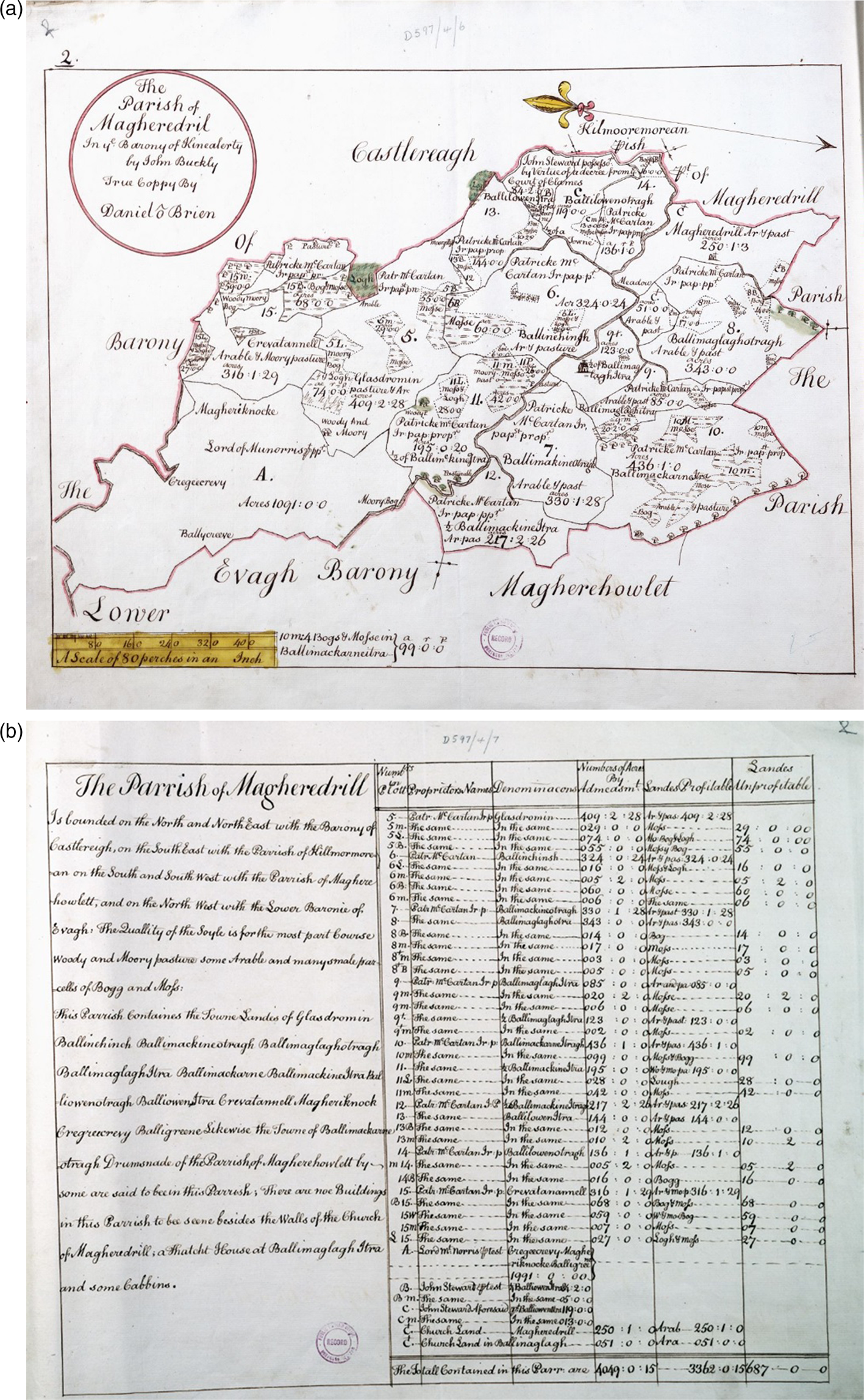
Fieldworkers were armed with a ‘methodicall, and comprehensive ffield booke’, containing tables in which they recorded distances and degrees measured. Field data were then used to draw plots of parishes and baronies on specially designed sheets of paper. The maps were finally bound with terriers or ‘books of reference’, which stated the acreage of profitable and non-profitable land and the names of proprietors and townlands within each parish or barony, as well as a description of its soil, buildings, roads, rivers and other objects that were to be noted (Figure 1).Footnote 44
1787–1788 copies of Magheredril parish map and appertaining terrier. PRONI D597/4/1. Courtesy of the deputy keeper of the records, Public Record Office of Northern Ireland.
Despite some incremental technical changes, these forms were fairly typical for contemporary land surveying.Footnote 45 More peculiar was the list of instructions that Petty issued to his fieldworkers. As the contriver acknowledged himself, he ‘gave out instructions to the respective instruments acting under him … far more large and comprehensive th[a]n those contained in his owne contract’.Footnote 46 The unconventional content of these instructions indicates that Petty seized the survey as an opportunity for extracting a broader natural-historical and topographical account of Ireland.
In principle, Petty's contract tasked him with surveying the boundaries together with all the characteristics affecting the value of each parcel, particularly whether it fell into one of the categories of arable, meadow, pasture or unprofitable terrain. However, besides prescribing criteria for classifying the productivity of land, the instructions ordered surveyors to record additional items, largely irrelevant for completing the land distribution itself. They were told to ‘take good notice of all highwayes and rivers, noting their breadth and depths, together with the falls and islands’, ‘the sea’, ‘navigable rivers’, ‘harbours’, ‘channels’ and ‘the heighth of all notoriouse high hills and mountaines, describing their feet and manner of rising, together with their names and true place’.Footnote 47
Barring some general directives for drawing the maps, Petty's instructions contained scarcely any technical guidelines on using instruments, or keeping field books, that one would expect from a surveying manual. While surveyors probably received such instruction orally and through trial use, the content of Petty's directions is still unusual when compared to contemporary surveying manuals.Footnote 48 I believe his instructions were intended to be not so much a guideline on how to survey land, as foremost a code of what was to be observed. In this regard they resembled Boate's interrogatory on the natural history of Ireland and other similar queries, which were then becoming a principal technique for managing natural-historical research in the British Isles. Like the history of trades, these questionnaires had been inspired by Bacon, who proposed that each history be prefaced with ‘topics or articles for interrogation’.Footnote 49 But while for Bacon these queries were principally a device for guiding an individual researcher in writing their natural-historical or experimental report, the Hartlib circle employed them as a tool for soliciting information from a network of associates. Hartlib, for instance, sent copies of Boate's interrogatory to his correspondents in Ireland, including Boyle and his sister Lady Ranelagh.Footnote 50
After 1660 questionnaires became a popular research strategy within the Royal Society. Its fellows and committees devised multiple sets of queries, which were addressed to travellers, navigators and other foreign correspondents.Footnote 51 Boyle, for example, prepared a questionnaire entitled ‘General Heads for a Natural History of a Countrey’, which was published in the society's journal, Philosophical Transactions, in 1666.Footnote 52 In 1692, a rearranged version of the General Heads was issued, to which were added nine questionnaires on different foreign countries. These queries were explicitly designed as a general ‘Method’ by which ‘Gentlemen, Seamen, and others’ are to ‘make Enquiries about things to be known’ in every country they travel to.Footnote 53
As with the history of trades, I believe that Petty's first use of a natural-historical query was the instructions for his surveyors, despite their different name.Footnote 54 If we compare Petty's instructions to Boyle's General Heads there exists, first, a similarity of content: they both demand information about rivers and their dimensions, as well as the heights of hills and mountains.Footnote 55 More importantly, however, they had a similar methodological function. As a query, Petty's instructions prescribed a selection of facts to be recorded. They directed the surveyors’ perception to recognize a specific order of noteworthy and negligible objects, much like the queries aimed to elicit particular observations from travellers and foreign correspondents. Petty's surveyors were to record hydrography, for instance, but not information on inhabitants or the weather.
Petty's instructions are exceptional because they did not merely train the perception of one or several correspondents, but calibrated a whole ministry of ‘instruments’, as he repeatedly referred to his soldiers.Footnote 56 There are two possible interpretations of this term. One is Aubrey's assertion that Petty instrumentalized the soldiers as unintelligent subordinates who ‘work't like Engines’.Footnote 57 As Petty himself wrote, the soldiers needed only to be ‘heedful and steady minded, though not of the nimblest witts’. Yet Petty also viewed his soldiers as instruments in the sense that they were tools capable of correcting the deficiencies of his own perception. Because of the scale of the project and to avoid being accused of embezzlement, ‘the Dr did not distinguish the lands in his owne person, but by his deputies’.Footnote 58 Like a telescope or compass, the soldiers enhanced Petty's power of observation in a technically restricted manner. They covered ground inaccessible to his own perception, providing information on regions he had never set foot in, but were calibrated to sense and record solely the signals contained in the instructions. Despite this distinction in their understanding of ‘instruments’, Petty's and Aubrey's interpretations exhibit a common fetishism insofar as they both equate the soldiers’ surveying labour with measurements performed automatically by unintelligent instruments, almost as if the chain carried and counted itself. Their portrayals of the soldiers conceal the work invested in these seemingly mechanic results. As demonstrated in discussing the division of labour, the infantrymen were trained in skills and knowledge that Petty lacked, yet indispensably relied on. Their abilities to round up informants, overcome rough terrain and identify or create landmarks to establish proprietary and administrative boundaries were necessary for extracting abstract measurements of acreage. It was also the soldiers who had to recognize the qualities of the soil and judge the profitability of each parcel, on which the success of the entire survey depended. The fieldworkers therefore did not merely measure Ireland as instruments, but also performed all the requisite work to render the terrain surveyable according to Petty's prescribed categories.
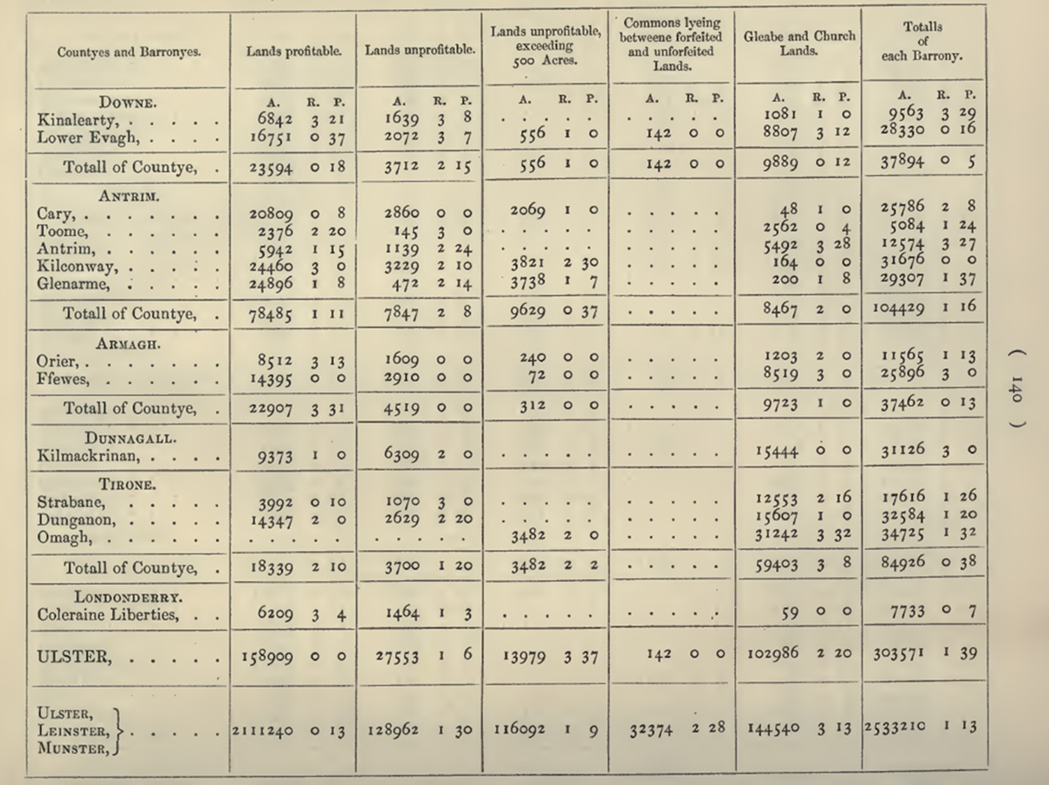
The soldiers’ and mearsmen's work became invisible once inscribed in field books and terriers, which mostly consisted of numerical data or succinct descriptions of natural facts. The instructions, combined with the other forms Petty imposed, not only directed the surveyors’ perception but also prescribed a common method of reporting their results, usually in well-ordered tables. Due to the instructions and the forms in which the workers were supposed to fulfil them, Ireland was brought before Petty's view already reduced to a schematic catalogue of items. As a supervisor sitting in a Dublin office, Petty experienced Ireland vicariously, through the neatly arranged data returned by his instruments. The same forms that fine-tuned and coordinated the observation of fieldworkers therefore also structured Petty's perception, allowing him to oversee and compare in a single view the lists and maps delivered from across Ireland. The manager's oblique perception is evident from the tables that were made in November 1656 based on the final documents which Petty submitted to the surveyor general. Intended as a summary account of Petty's assignment, these tables contain calculated sums of acres of profitable land, unprofitable land, church lands and commons for every barony and county targeted by the Down Survey (Figure 2). Petty's intellectual product was hence an agglomeration of data deposited by his surveyors. From his supervisory position, Petty could view Irish territory not as a country revolting against surveying and dispossession, but as an abstract two-dimensional space depicted on maps and defined by a summary of cadastral and natural-historical particulars.
A Particular of the Contents of the Baronys admeasured by Dr. Petty. William Petty, The History of the Survey of Ireland, commonly called the Down Survey (ed. Thomas Larcom), Dublin: Irish Archæological Society, 1851, pp. 137–41.
Over a decade after the survey, in 1672, Petty wrote a manuscript entitled The Political Anatomy of Ireland, which is presently held to be a trailblazing contribution to statistical analysis and political economy. In the first chapter on the ‘Lands of Ireland’, Petty reused some of the same categories he had first introduced for the purposes of the Down Survey. He gives a rough quantitative estimate of Irish land, which he subdivides into areas covered by rivers, highways, bogs, rocks and surfaces that qualify as ‘good Meadow, Arrable and Pasture’. He further enumerates the sizes of properties owned by the church, the adventurers, soldiers and officers. The objects examined in his statistical treatise thus largely correspond to the items measured in the Down Survey.Footnote 59
To return to Hacking's introductory statement, Petty did not suddenly realize that facts about land can be used to analyse Ireland as a ‘body politic’, a collective entity with its own characteristic traits and tendencies. His statistical observations were rather a consequence of the conditions of visibility determined by the division of labour and by the forms instituted to collect and order information during the Down Survey. From his position of compiler and contriver, Petty was able to see Ireland as a table of aggregate data. The material conditions of his work enabled and prompted him to think about Ireland in terms of total size of land, its sum value, and representative groups of landowners. Just like his ‘instruments’, his work post calibrated him to see in this manner, focusing on these particular facts. His statistical ideas did not simply appear in his mind ‘motivated by God, or by gaming, or by commerce’, as Hacking would have it, but were the end product of a work scheme contrived to execute the Down Survey.Footnote 60 Most saliently, it was acting as a natural historian that Petty organized the collection of data of an appropriate size and form to be able to make his statistical observations. On the one hand, he drew on histories of trade to streamline surveying work. On the other hand, he borrowed from natural history the use of standard forms for ordering individual reports into a systematic ‘accompt’ of Irish land.Footnote 61
This would not be the last time that Petty relied on natural-historical methods to arrive at statistical and politico-economic conclusions. In 1661, he presented a description ‘Of making cloth’ to the Royal Society's history-of-trades committee, in which he surveyed the materials, gadgets and ‘ingenium’ of every individual operation involved in manufacturing cloth. Years later, in his famous Political arithmetick, Petty used the example of clothmaking to illustrate that dividing labour lowers commodity prices. He thus derived a general economic concept from a phenomenon initially identified in the context of histories of trades.Footnote 62 A similar transposition occurred with queries. After the Irish survey, Petty composed several drafts of questionnaires on diverse subjects, including fire, life and death and the ‘nature of the Natives of Pensilvania’.Footnote 63 He also deployed queries to obtain reports from agents managing his own Irish estates, hence applying the method previously used to account for Irish territory to account for his Irish revenue.Footnote 64 The most exceptional among Petty's queries, though, is an undated manuscript entitled ‘The Method of Enquiring into the State of any Country’.Footnote 65 Written as a three-page questionnaire, it replicates some of the typical questions found in other natural-historical queries, for instance on ports, tides, currents and the weather. The bulk, however, is dedicated to socio-economic and demographic matter: the population of a city, the proportion between men and women, the price of grain, average day wages for common professions, the structure of government and so on. Petty thus treated the questionnaire as a general method of inquiring into the state of a country. He regarded it as a technique for accumulating data on the representative phenomena, both natural and politico-economic, that make up and define a certain territory. Similar to the history of trades and division of labour, Petty transformed a method developed within natural history into a form of statistical and politico-economic analysis. As he proclaimed himself in the opening of Political Anatomy, he approached the study of Ireland as a ‘Physician’ – an observer of physis – who merely extended his dissecting techniques from the structure of the ‘Body Natural’ to the constitution of the ‘Body Politick’.Footnote 66
Situating the other Columbus
Although in many ways inspired by Bacon, the Down Survey and Petty's later writings reveal a different view on natural history and its relation to natural philosophy. While Bacon saw natural history as a rich source of ‘materials for the intellect’, he thought it ‘beneath the dignity of [his] enterprise to spend [his] own time’ collecting and ordering historical particulars, and focused instead on elaborating a ‘true logic’.Footnote 67 Unlike Bacon, Petty did not regard history as subordinate to philosophy. In his work, natural history is assumed as a self-sufficient research practice, tasked with governing the accumulation of facts. Petty's model naturalist – the Compiler – is neither an artisan, completely immersed in the craftwork itself, nor a natural philosopher. He is rather ‘a contriver of the way and method how many surveyors should worke, th[a]n a surveyor’ himself, as Petty epitomized his own role in the Down Survey.Footnote 68 For him, method is not so much a question of logic as of logistics. He is less preoccupied with a universal instrument of reason than with schemes for organizing a company of instruments. The methodological focus correspondingly turns from general rules of philosophical interpretation to strategies for dividing work, collecting data, examining the reliability of data gatherers and ordering bits of information into tables, catalogues and other forms of ordered representation.
A similar methodological attitude is on display in the author potentially closest to Petty, the other ‘Columbian’ discoverer of statistics, John Graunt, and his Natural and political observations upon the Bills of Mortality (1662). In what follows, I show that Graunt relied on similar techniques to those used by Petty in the Down Survey to order data, gathered by numerous workers, into forms of representation that enabled him to discern population trends. Graunt himself classified his treatise as belonging to natural history.Footnote 69 And like Petty, he presented his approach as a general method of inquiring into the natural and political state of a given territory.
The main difference between the Observations and the Down Survey is that Graunt did not command a garrison of surveyors and had to depend on already existing bills recording the number of weekly burials in London. The information in these documents was gathered by ‘searchers’ – laypeople who examined corpses and reported on the cause of death to the parish clerk. Because Graunt was not involved in contriving the bills, he could not train the searchers beforehand or give them instructions as Petty did with his soldiers. To ensure the reliability of his observations, he therefore had to establish ex post facto that the searchers’ ‘own senses are sufficient’ to estimate the age of the deceased and correctly distinguish between different causes of death, like ‘Drowning, Scalding, Bleeding, Vomiting, making-away them selves, Lunatiques, Sores, Small-Pox, &c’. He concluded that the ‘ignorance of the Searchers [was] no impediment to the keeping of sufficient and usefull Accompts’ since they were overall ‘able to report the Opinion of the Physician’.Footnote 70
Whereas Petty's managerial post empowered him to standardize criteria for discriminating types of land in advance, Graunt was obliged to assess the readings of his instruments retroactively. Furthermore, since Graunt was not in a position to prescribe preset forms to the searchers, their reports were piled in what he found to be ‘several great confused Volumes’. Instead of data being ordered in a uniform manner as it was gathered, Graunt had to file and arrange it himself. He obtained all available bills from the parish clerks and then reduced them into ‘a few perspicuous Tables’
so as to have a view of the whole together, in order to the more ready comparing of one Year, Season, Parish, or other Division of the City, with another, in respect of all the Burials, and Christnings, and of all the Diseases, and Casualties happening in each of them respectively.Footnote 71
The first two chapters of Graunt's treatise are entirely devoted to evaluating the reports of lay observers and recapitulating how he ordered the bills into tractable tables. Only after completing ‘all this laborious buzzling, and groping’, as he referred to his preliminary travails, could Graunt observe population phenomena and trends, like periodical changes in the number of inhabitants.Footnote 72 Although the chronological sequence of Graunt's work was reversed when compared to Petty's survey, their methods and results are largely comparable. Graunt too became aware of population phenomena while processing and ordering data gathered by a collective of mostly uneducated, but practically trained, labourers. And, as with Petty, his different way of seeing data was made possible by the methods employed to organize information.
Interestingly enough, Graunt concluded his discourse by laying out a query consisting of thirteen questions about the numbers of people, men, women, married and single individuals, fighting men, deaths from different causes and so on. Based on this knowledge, he suggests, one could further inquire into the proportion of people employed in ‘necessary Labours’ and ‘meer Voluptuaries’. A ‘clear knowledge of these particulars’, he stresses, is ‘necessary in order to good, certain, and easie Government’. Akin to Petty, Graunt's observations prompted him to adopt a natural-historical technique – the questionnaire – as a method of analysing ‘matters of Government and Trade’. The questionnaire represented for him a technique for extracting knowledge about ‘the Land, and the hands of the Territory to be governed’, which he viewed as the foundation for a true ‘Art of Governing’.Footnote 73
In completing a work classified as natural history by contemporary standards, Graunt struck upon an object that was simultaneously natural and political. As he announced in the opening of his discourse, ‘The Observations, which I happened to make (for I designed them not) upon the Bills of Mortality, have fallen out to be both Political, and Natural’.Footnote 74 Whereas Petty's management of the survey alerted him to the importance of a systematic account of land for dissecting the body politic, Graunt's tabulation of the bills led him to recognize a ‘true Accompt of the people’ – their age, gender, diseases, mortality and other physical properties – as an object of government. Surveying a territory, its land and inhabitants, became for them a manner and matter of inquiry into the state of a country.Footnote 75
Territorial natural history
I believe that Petty's and Graunt's work is characteristic of a specific style of natural history, which can be labelled territorial natural history. Their goal was not to compare the qualities of land or people from around the world in order to draw general conclusions about nature or mankind, but to analyse these particulars within a confined territory. This tradition of natural history stands in sharp contrast with classical and Renaissance natural histories, usually composed as delocalized encyclopedic collections of curiosities and legenda sourced from diverse places, as well as Bacon's image of natural history as a ‘worldwide perambulation’ of ‘Phaenomena of the Universe’.Footnote 76 Bacon's object is global, not spatialized. But to make observations about phenomena appearing on the level of a political body as Graunt or Petty did, natural-historical investigation must be restricted to a defined space. It is only by studying variation in the population of London or the value of land in Ireland that one can spot regularities in the collected data and thus determine the ‘state’ of these collective territorial entities. In both the Down Survey and Graunt's Observations, although the former surveyed land and the latter people, the object of analysis is inscribed into a bounded administrative unit. Even when land is not the principal item of consideration, reference to a circumscribed territory is therefore indispensable for producing the type of knowledge that Petty and Graunt endorsed.Footnote 77
The purpose of this section is to explore later manifestations of territorial natural history and thereby indicate the extent to which Petty's use of natural-historical techniques in the Down Survey can be taken as an illustration of a more ubiquitous research tradition that solidified itself in the British Isles from the 1660s. Broadly speaking, this tradition developed in two directions: one targeting English colonies and foreign countries, the other inventorying regions of the British Isles. The paradigmatic surveying technique of these enterprises became the query. Since myriad examples of such questionnaires exist, my aim is not to be exhaustive but to describe the general traits of territorial natural history as a mode of inquiry into the state of a country, and its seamless transformation into statistics by the end of the eighteenth century.
The early Royal Society played a central role in accumulating knowledge about ‘remote countries’, becoming a hub for questionnaires tailored to individual foreign territories. In December 1666, for instance, lawyer John Hoskyns and the society's secretary, Henry Oldenburg, drafted ‘Inquiries for Turky’ consisting of twenty-three questions on the uses of opium, the manufacture of Damascene steel, aqueducts, horse breeding, ‘the height of Mount Caucasus’ and the ‘excellent Works of Antiquity’ located there. The queries were entrusted to Paul Rycaut, appointed to become the Levant Company's consul at Smyrna, and strategically elected fellow of the Royal Society in the same session that the inquiries were read and registered. The questionnaire was further published in Philosophical Transactions, ‘desired also to be taken notice off by others, that may have occasion to visit’. Rycaut returned relatively substantial answers on 23 November 1667, while also composing a three-volume monograph, The Present State of the Ottoman Empire, which he quotes in his responses.Footnote 78
The design, publication and dissemination of questionnaires for other territories followed a congruent pattern. Usually informed by anterior natural-historical and travel accounts, they inquired into phenomena and features located on a more or less precisely delimited territory, such as the flooding of ‘River Niger’ or whether ‘some People on the River Gambra, be only Tawny’ whereas ‘others very Black?’Footnote 79 They covered diverse topics, from trades and uses of natural resources to topography, climate, antiquities and local custom. Some questions concerning tides, navigable rivers and mountains resemble sections of Petty's instructions. Like the Down Survey, the production of natural-historical knowledge about overseas countries depended heavily on English colonial trade and government for sources of information. The society's respondents were usually either envoys and officials, like Rycaut in Turkey, Thomas Lynch in Jamaica, Edward Digges and John Winthrop Jr in North America, or their employees, frequently personal physicians.Footnote 80 Different types of expansion to foreign lands brought about different kinds of collaborators and subordinates, from whom correspondents actually obtained their information. In cases of colonial trading posts, rather than full-blown occupation, these informants were most often entrepreneurial go-betweens, such as a man in Aleppo who for a fee offered to teach the Royal Society's correspondent the ‘secret of tinging Damascus steel’. In occupied territories, like Jamaica, their status was closer to Petty's Irish mearsmen who reported information under compulsion.Footnote 81
In parallel, queries became an emblematic method in natural-historical studies of mainland Britain. In the 1670s John Ogilby, publisher appointed as royal cosmographer, convoked a group consisting of Hooke, Aubrey, Hoskyns, architect Christopher Wren and surveyor and engraver Gregory King to prepare two sets of queries for the fifth volume of Ogilby's descriptive atlas, Britannia. Several questions from one query closely coincide with Petty's surveying instructions. Some historians credit Hooke with introducing the questionnaire as the research technique of Ogilby's team. As a fellow of the Royal Society, Hooke had assisted in preparing natural-historical queries on various subjects. In a posthumously published methodological treatise, Hooke expounded that the purpose of such enquiries was to have ‘particular Instances … all presented at once to the View: Their Order, Congruity, Disagreement, Similitude, &c. … all manifest to the Eye’. Exactly like Petty or Graunt, Hooke eyed the queries as a technique for organizing piles of information into a systematic accompt, a ‘view of the whole’ in which patterns and regularities become apparent.Footnote 82
Questionnaires rapidly spread as a standard tool for surveying the natural-historical features of a chosen territory. Plenty has been written on Robert Plot's deployment of queries in his county natural histories, William Molyneux in Ireland, and Robert Sibbald in Scotland. Edward Lhwyd's ‘Parochial Queries’ for a ‘Geographical Dictionary’ and ‘Natural History’ of Wales deserve special attention, though, because they assigned a similarly broad scope to natural history as did Petty. Issued in December 1696, Lhwyd's inquiries are split into two sections: queries regarding geography and antiquities, and those concerning natural history. The first two questions related to natural history ask about the fertility of the land; whether it generally comprises pasture, barren, rocky or mountainous ground; what kind of grain is sown; and the number of livestock bred. Lhwyd's questionnaire hence classified the type of politico-economic and cadastral particulars, catalogued in the Down Survey, under natural history.Footnote 83
In the eighteenth century, questionnaires proliferated with the instauration of new learned associations, like the Society of Antiquaries in 1707 and the Physico-Historical Society of Dublin in 1744, along with periodical magazines, newspapers and scholarly journals where queries were publicized.Footnote 84 These currents culminated in the work of John Sinclair, a Scottish lawyer, Member of Parliament and fellow of numerous scientific associations, including the Royal Societies in London and Edinburgh and the Society of Antiquaries. Between 1791 and 1799 Sinclair published The Statistical Account of Scotland in twenty-one volumes, which presented data gathered from questionnaires sent to ministers in every Scottish parish. Apart from amassing more abundant data than prior surveys, Sinclair's work is remarkable because it explicitly announces the transition from territorial natural history to statistics.
The Statistical Account is sometimes cited as the first use of ‘statistical’ and ‘statistics’ in English.Footnote 85 Yet according to their title the queries Sinclair dispatched in 1790 were still ‘drawn up for the purpose of elucidating the Natural History and Political State of Scotland’. Expanding on previous questionnaires, they encompassed 166 questions classified under four headings. First, ‘Questions respecting the Geography and Natural History of the Parish’, which like so many earlier questionnaires inquired about the air, soil, place names, notable landmarks, mines, hydrography, coastline, flora, fauna and any other ‘remarkable phenomena’. Second, ‘Questions respecting the Population of the Parish’, demanding information on the annual births and deaths, the number of men and women, farmers, manufacturers, seamen, students, ‘negroes, gipsies, foreigners’ and two dozen additional categories of people. Third, ‘Questions respecting the Productions of the Parish’, which touched on certain agricultural products and the acreage dedicated to their cultivation. Lastly, ‘Miscellaneous Questions’, ranging from ‘usual wages’ of servants in husbandry to ‘pieces of antiquity dug up in the parish’. Sinclair's questionnaire hence represents a more comprehensive inventory of similar items that had already preoccupied prior territorial surveys. Nonetheless, he decided to adorn his inquiry with a more fashionable title – Statistical Account – hoping ‘that a new word might attract more public attention’. He professes his terminological outlandishness in the preface: ‘Many people were at first surprised, at my using the new words, Statistics and Statistical’. Sinclair reveals that he learned this neologism on his tour to Germany but chose to ‘apply a different idea to that word’. Whereas Germans, he explains, treat statistics as an inquiry into ‘the political strength of a country’, he conceives it as an ‘inquiry into the state of a country’. Sinclair thus defined his new term with an old expression – ‘state of a country’ – which had become a set phrase in historical studies of foreign and British territories. It appeared in the titles of numerous monographs, such as Rycaut's Present State of the Ottoman Empire or Gregory King's observations on the ‘State of England’. Most significantly, Petty employed the phrase ‘method of enquiring into the state of any country’ to designate his draft questionnaire, which closely matches the content of Sinclair's queries. Sinclair therefore simply gave a fancier name to a long-established practice of natural-historical, chorographic, topographic and geographical surveys – a research tradition I referred to as territorial natural history.Footnote 86
Conclusion
From the Down Survey and other examples one can infer three essential traits of territorial natural history as practised in the British Isles between roughly 1650 and 1800. First, it was a profoundly spatial knowledge. The unit of analysis was invariably either a civil or ecclesiastical administrative division – like a parish, barony or county – or an entire state, increasingly so as the eighteenth century advanced. Even when a whole country was surveyed, this was usually accomplished by proceeding by local districts, most notably the parish, as seen in the Down Survey, Graunt's Observations or Lhwyd's and Sinclair's later questionnaires. An administrative unit thus came to constitute an object of knowledge – a body inspected as a receptacle of facts. Researchers belonging to this tradition studied more or less arbitrarily construed territorial divisions as natural regions, defined by an amalgam of their unique topography, flora, fauna, climate, buildings, agriculture, industry, antiquities, inhabitants and custom. Territorial natural historians collected these dispersed, and often miscellaneous, particulars and organized them into a systematic account of the ‘true State of the Nation’, as Petty marvellously put it.Footnote 87 Arable land, daily wages and the deceased were no longer treated as distinct singular phenomena, but as facts and regularities that all pertained to a political body, like Ireland, and which, considered together, characterized this supra-individual object. By systematically extracting knowledge about regional features, researchers naturalized these politico-juridical entities into tangible bodies with stable identities. This effect of natural-historical territorial description is particularly prominent in the colonial context, where surveys served to consolidate new administrative divisions that had been instituted by colonial occupation. Petty's survey, for instance, filled the baronies and counties, which English colonization had imposed on Ireland, with data about their supposedly pre-existing natural and social properties, thus endowing them with a purportedly palpable objectivity.
Second, territorial natural history indiscriminately intertwined facts about nature with particulars related to what some contemporary authors dubbed ‘civil’ or ‘moral history’. Territorial histories never encompassed merely the natural landscape and growth, but ordinarily also recorded the medical, commercial, and culinary exploitation of natural resources, agriculture, manufacture, diseases, weights, measures, political institutions, antiquities, law and folklore. To repeat Petty and Graunt's cherished expression, the ambition was to furnish an account of the ‘lands and hands’, a systematic survey of the relations between a territory, its inhabitants and their activities. Depending on the work concerned, heavier emphasis was placed on either natural or politico-economic aspects.
Third, as natural history evolved into an independent research practice, questions of method turned from rules of logic for disciplining individual reasoning to logistical schemes for collective accumulation of data. As demonstrated on the Down Survey, this logistics entailed not only dividing labour and instrumentalizing a garrison of specialized workers, but also imposing standard forms. The purpose of the latter was to order information reported from diverse ends, desirably as it was being gathered, to enable the managing naturalist to detect patterns and regularities in the surveyed territory. It was by observing voluminous collections of data in these ordered forms of representation that naturalists like Petty or Graunt could discern trends and phenomena pertaining to a political body, rather than individual cases (such as aggregate value of land, average births). The most popular, albeit not exclusive, standard form was queries and instructions. The main obstacle to territorial natural history, particularly in the seventeenth century, was the paucity of informants, financing and institutional support. Naturalists in the British Isles usually depended on private and voluntary initiative, which often failed to produce (consistent) responses. These issues were partially overcome in the eighteenth century by relying on the clergy, nobility and gentry, for both distributing and answering the questionnaires; and, finally, in the second half of the eighteenth century and in the nineteenth with the establishment of specialized military and governmental bodies, which had at their disposal a larger pool of personnel for conducting territorial surveys. Petty's survey of Ireland was in many regards ahead of its time, availing itself of the Cromwellian military infrastructure. It therefore provides a unique example which displays the full extent of the otherwise seldom-realized ambitions of territorial natural history, while hinting at continuities with survey sciences and descriptive statistics in the late eighteenth century and the nineteenth.
Territorial surveys were not the only way of utilizing natural-historical queries. Alongside territorial surveys a distinct style of natural history existed, which was not directed at circumscribed regions but rather collected and compared particulars from across the world to construct general propositions about nature. This delocalized approach is personified in Robert Boyle, an avid accumulator of strange phenomena. Besides participating in the Royal Society's production of queries, he also interviewed travelling gentlemen, merchants, scholars and navigators, keeping a substantial record of their statements, known as his ‘Outlandish Book’. His writings are filled with references to foreign reports, like the observations of fishermen and divers about the coldness of the deep sea along the African coast or the testimony of ‘A Man of Letters’ who encountered snow ‘on the high Mountain in the Island of Ceylon’. However, Boyle's intention was not to complete a natural history of Ceylon. He gathered these testimonies to formulate claims about ‘Systematical or Cosmical Qualities’ of natural things – heat, cold, density, fluidity and so on. Like other members of the Royal Society, Boyle would, for instance, collect reports on steelmaking in Damascus or the skin colour of enslaved Africans in America, but processed this information into a ‘porology’, a general study of the ‘porousness of bodies’, or an abstract discussion on the causes of blackness. Space was for him less an object of investigation than a variable that may reveal unexpected qualities of matter.Footnote 88 Another practitioner of this style of natural history was John Locke, who supplied weather charts for Boyle's General History of the Air and engaged in distributing diverse questionnaires. Mirroring Boyle, he relied on overseas reports about exotic natural phenomena, as well as about custom, religion and language, to produce general claims about human understanding and morals. Although the disparity between globally oriented and territorial natural history should be noted, they were not conflicting endeavours. Naturalists regularly pursued both lines of research. Hooke drafted a set of inquiries concerning the air while assisting in Ogilby's and Moses Pitt's territorial surveys. Petty also took a break from political arithmetic to draft a query for a natural history of fire. Territorial and ‘global’ natural history were thus distinct, but concurring, modes of research practice, linked by the common queries, societies and empire of informants.Footnote 89
Finally, though my article is restricted to the British Isles, territorial natural history was far from an English phenomenon. The appearance of this research practice dates back at least to the questionnaires circulated in Spanish American colonies and the Iberian mainland during the reigns of Charles V and Philip II. These queries covered a similarly broad array of topics as their later English equivalents and relied on a comparable, perhaps even wider, network of informants. The responses to the colonial questionnaire from 1577, known as the Relaciones Geográficas, later became a standard reference among eighteenth-century Spanish researchers in designing statistical and cadastral surveys.Footnote 90 An analogous transition, leading from territorial natural-historical surveys to statistics, occurred in France with the instauration of departmental statistics in 1801. Following a standard instruction issued by the interior minister, which explicitly cited Sinclair's Statistical Account as a model, each prefect was to chart their department's topography, population, meteorology, habits, agriculture and so on. Like Sinclair's work, this Napoleonic project of describing the new revolutionary administrative divisions impressed the name ‘statistics’ on a practice that closely resembled earlier territorial natural-historical surveys.Footnote 91 Further comparative research along these lines would be necessary to reliably estimate the pervasiveness of territorial natural history and its impact on the history of statistics.
Acknowledgments
I am immensely grateful to Staffan Müller-Wille for reading numerous drafts of this paper and helping me develop my initial idea into its current form. A special thanks to Olin Moctezuma-Burns for her scrutiny and for inviting me to present an earlier version of the article at the Cabinet of Natural History in Cambridge. I also thank Simon Schaffer for his support and generous insights, as well as the reviewers and the editor for their many valuable comments and improvements. Research was funded by the Slovenian Research and Innovation Agency (ARIS).


 Open access