

Introduction
World maps allow their readers to take in the whole world at one glance. By finding one’s hometown or country on a map, readers can imagine themselves as part of a greater whole, to become a cosmopolite—a world citizen. At the same time, when designing these maps, their makers have to make choices about what to include and what to exclude, thus constructing a ‘world’.Footnote 1 The concept of the ‘world’ changes over space and time. In early modern China, the voyages of Zheng He 鄭和 (1371–1433) brought established trade routes in the Indian Ocean even more closely into the geographic imagination of the scholarly elite. From the late sixteenth century, Jesuits entered these discussions on world geography, and the Manila galleon trade across the Pacific between the late sixteenth and early nineteenth centuries brought the worlds of China and the Americas closer together. As a result, the period between the fifteenth and eighteenth centuries saw the creation of many artefacts that engage with world geography and ideas of cosmopolitanism, continuing mapping practices that were particularly influential during the thirteenth and fourteenth centuries when the vast Mongol empire ruled much of Eurasia.Footnote 2 Maps therefore can help us to understand one aspect of the cosmopolitan pasts of China, the topic of this special issue. In this article, I will follow Gerard Delanty’s proposal to examine cosmopolitanism, avoiding Eurocentric definitions and uncovering Chinese understandings of cosmopolitanism through the lens of mapmakers.Footnote 3
One concept that can be understood as a Chinese idea of cosmopolitanism is that of tianxia 天下, usually translated as ‘All-under-Heaven’.Footnote 4 Defining tianxia is not easy: it can be interpreted as a political construct, a world view, a cultural and philosophical set of values, and a geographical concept.Footnote 5 The meaning of tianxia did not remain the same throughout history, further complicating our understanding of the term.Footnote 6 Even in strictly geographical terms, tianxia is ambiguous: does it describe the part of the world directly under the control of the currently ruling ‘Chinese’ state(s) or the whole world, including where no ‘Chinese’ state exerts control? How were regions the Chinese states had diplomatic ties with distinguished from those they did not?
At least for the geographical aspect of the question—where is tianxia?—maps can provide an answer. Previous research has identified a set of maps collectively called tianxia maps based on their geographic scope.Footnote 7 These maps show the Ming and Qing empire at the centre, surrounded by several other countries. They have been considered ‘world maps’, representing an earlier Chinese world view and have been understood as representing a phase of Chinese mapmaking that was slowly replaced by ‘modern’ mapping practices and a wider knowledge of the world.Footnote 8 This line of research creates two issues that hinder us from fully considering the spatial extent of tianxia. By equating the concept of tianxia with ‘world’ and declaring these maps ‘world maps’ without considering when they were made and without conducting a detailed analysis of the space shown on the maps, we are led to assume a lack of knowledge on the part of the Chinese mapmakers. The geographic scope of what constitutes the ‘world’ expanded over time through exploration, newly formed trade connections, and exchange. Nevertheless, what we can observe on many of the maps that have been called tianxia maps is that, despite the trading links of the Ming and Qing across the Pacific, the Americas are usually absent. Can we therefore really call this set of maps ‘world maps’ when they were made at a time when these trade connections existed? Secondly, although previous research has grouped these maps together based on a similar concept of space, not all claim to be maps of tianxia. Yet, from the fifteenth century onwards, maps exist that use the term tianxia in the titles. When considering maps with the term tianxia in the titles, we end up with a set of maps substantially different from those discussed in the previous literature. Looking in detail at the titles of the maps and the extent of the space they claim to show, can reveal where the mapmakers thought tianxia to be.
The title is an important element of a book or a map. It shows the reader what they can expect by advertising the contents.Footnote 9 Titles are sometimes hard to determine with certainty, as Gérard Genette points out, yet they are a fundamental element of a book.Footnote 10 In the case of Chinese books, difficulties arise in identifying the title when different titles are used in various places within a book (such as cover pages or the statements at the beginning of a juan) to refer to it.Footnote 11 Maps as well do not always have one single, easy-to-identify title. Considering elements of their titles can help uncover the relationship between maps or lead to a better understanding of the contents and, in the case of Chinese maps, how the mapmakers positioned China in the world.Footnote 12 The term tianxia closely relates to other terms that situate China in the wider world which appear in the titles of maps: huayi 華夷 (civilized and barbarian/Chinese and non-Chinese), siyi 四夷 (four barbarians), wanguo 萬國 (10,000 countries), and sihai 四海 (four seas). Like tianxia, each of these terms was continuously being redefined and reinterpreted.
For this article, I have collected 70 maps from the fifteenth to eighteenth centuries that either show the Americas (comprising just over a third of the 70 maps) or that have one of the terms tianxia, wanguo, huayi, or siyi in its title. Except for maps with huayi in the title, no map meets these criteria prior to the fifteenth century, and nearly all 70 maps date to the second half of the sixteenth century or later. The majority are maps published in books, most of them geographical works by commercial publishers that were aimed at a wide readership. Due to the publishing practices during the Ming and Qing, these 70 maps are not all completely different images; they often look very similar with only minor differences, sometimes including a change in title. By discussing tianxia and other related concepts used in this set of maps, this article aims to shed light on the geography of tianxia, what mapping the world in fifteenth- to eighteenth-century China entailed, and the extent to which these maps expressed cosmopolitanism.
A map of the Ming empire or a map of tianxia?
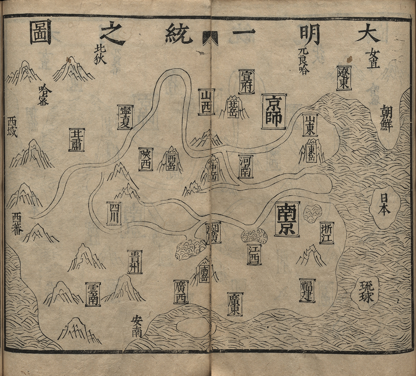
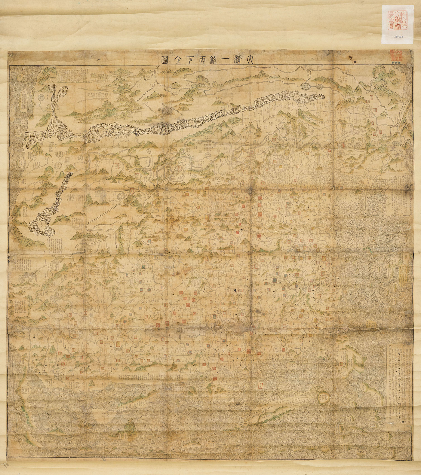
Early to mid-Ming geographical works equated the extent of tianxia with that of the Ming state. In 1461, the Ming state published a gazetteer—Da Ming yitong zhi 大明一統志 (Gazetteer of the unified great Ming)—describing the geography of the whole empire. At the beginning of the book there is a general map of the Ming state and a map for each of its provinces. At the top of the general map is the title ‘Da Ming yitong zhi tu’ 大明一統之圖 (Map of the unified great Ming; Figure 2), but the preface to the gazetteer describes the first map in the volume as a ‘Tianxia zongtu’ 天下總圖 (Complete map of tianxia).Footnote 13 The preface also outlines the division of tianxia into circuits and provinces over the course of history, portraying tianxia as the region the ‘Chinese’ state had control over. Due to the popularity of the gazetteer, other scholars replicated this map in their own privately or commercially published works. Most of them keep the title of the map as ‘Da Ming yitong zhi tu’, but a 1541 commercial guidebook to the geography of the Ming changed it to ‘Da Ming yitong tianxia zhi tu’ 大明一統天下之圖 (Map of the unified great Ming of tianxia), which makes it the earliest extant map I am aware of with tianxia in its title.Footnote 14 Aside from labelling the provinces of the Ming state, both maps name a few non-Chinese places and peoples such as Japan, Korea, Ryukyu, the Western Region, the northern ‘barbarians’, and the Jurchen.Footnote 15 These places and peoples are described in the last two chapters of the gazetteer under the heading ‘Outer barbarians’ (waiyi 外夷), a common way of labelling chapters in the non-Chinese world in Ming geographical texts. However, the places on the map were not all the non-Chinese countries and peoples the state gazetteer mentions in its last two chapters, they were simply countries and regions directly bordering the Ming state, making this not a world map but a map of the Ming and its direct neighbours.
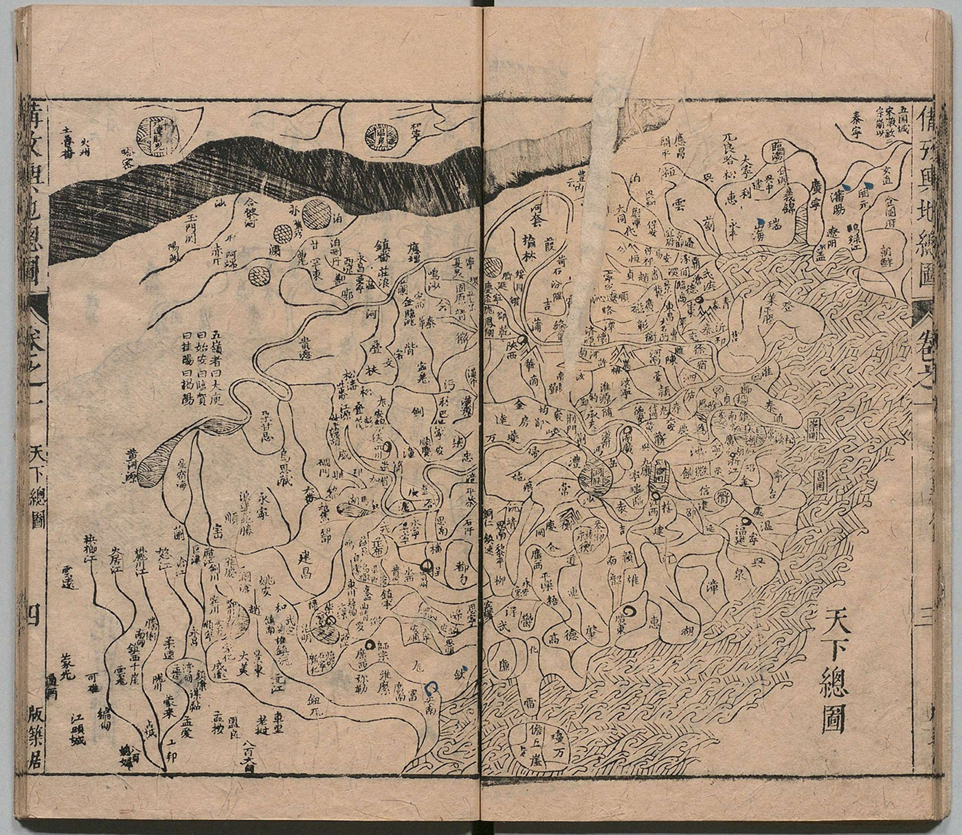
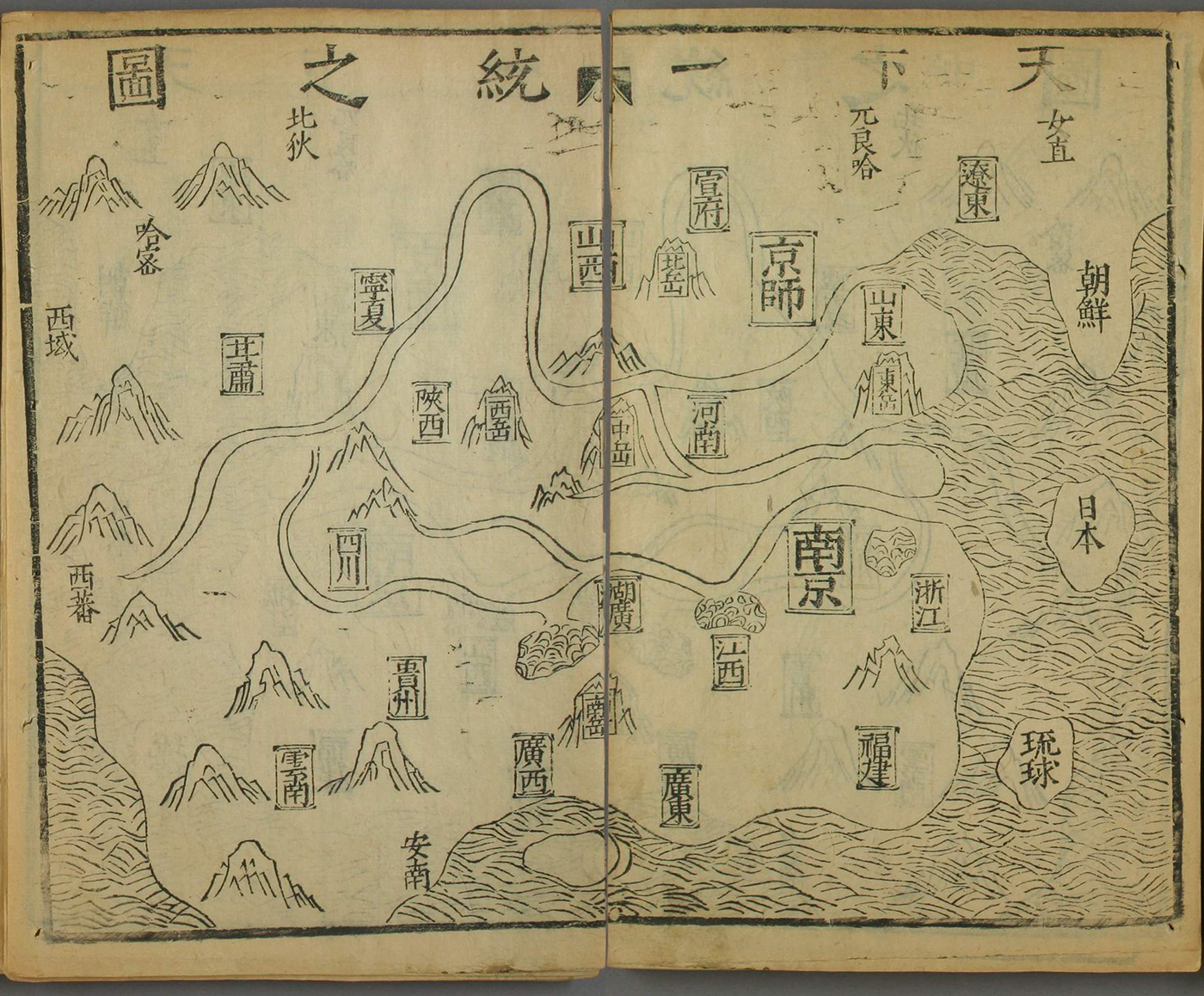
In the mid-seventeenth century, both before and after the Qing takeover of Beijing in 1644, more books started to feature maps with tianxia in the title. In the Huiji yutu beikao quanshu 彙輯輿圖備攷全書 (Complete reference book of collected maps, 1633), as well as in a Qing edition of the Guangyu ji 廣輿記 (Record of extended lands), the general maps of China are titled ‘Tianxia zongtu’ (Figure 1).Footnote 16 Similarly, the 1645 Ditu zongyao 地圖綜要 (Complete essential maps) includes a map titled ‘Tianxia yudi fenli zongtu’ 天下輿地分里總圖 (Complete map of tianxia and the lands divided by li).Footnote 17 The layout of these maps resembles that of the general map of China found in other geographical works, usually titled ‘Yudi zongtu’ 輿地總圖 (Complete map of the lands) (or similar), without invoking tianxia.Footnote 18 A similar process of changing the title of a map from one of the Ming empire to one of tianxia can be seen in an edition of the general gazetteer of the Ming, which exists in two versions: the first is titled Da Ming yitong zhi and keeps the title of the map ‘Da Ming yitong zhi tu’. Sometime after 1644, the same printing blocks were used to make a new print run. The blocks, however, needed to be altered: the characters ‘Da Ming’ were carved away and were replaced by ‘Tianxia’. The title of the book became Tianxia yitong zhi and of the map ‘Tianxia yitong zhi tu’ (compare Figures 2 and 3). The Ming existed no more, but the term tianxia proved to be a fitting replacement.
‘Tianxia zongtu’ in Huiji yutu beikao quanshu (1633). This map shows the geography of the Ming. Height of paper circa 26 cm. Source: National Archives of Japan, Tokyo, Japan.
‘Da Ming yitong zhi tu’ in a late Ming edition of the Da Ming yitong zhi published by Wanshoutang 萬壽堂. Height of paper circa 25 cm. Digitally assembled. Source: Bayerische Staatsbibliothek, 4 L.sin. D 70-1, Munich, Germany.
‘Tianxia yitong zhi tu’ in Tianxia yitong zhi published by the Wanshoutang. This print is from a later print run of Da Ming yitong zhi, where the characters for ‘Da Ming’ were replaced by ‘Tianxia’ by altering the printing blocks. Height of paper circa 25 cm. Digitally assembled. Source: Waseda University Library, Tokyo, Japan.
That general maps of China started to be titled maps of tianxia more frequently around the time of the transition from Ming to Qing is no coincidence. The Ditu zongyao includes a preface dated to the spring of 1645 by a scholar from Jiangxi, a region that was at the time still in the hands of the Southern Ming. This preface explains that tianxia (and not the Ming state) was ‘in chaos’.Footnote 19 The Manchu conquest had implications that went beyond a simple matter of territoriality, pushing scholars and publishers in the early Qing to highlight that the Ming was tianxia, an idea that already existed. Throughout the Ming and the first decades of the Qing, the extent of tianxia was equivalent to the extent of the Ming empire.
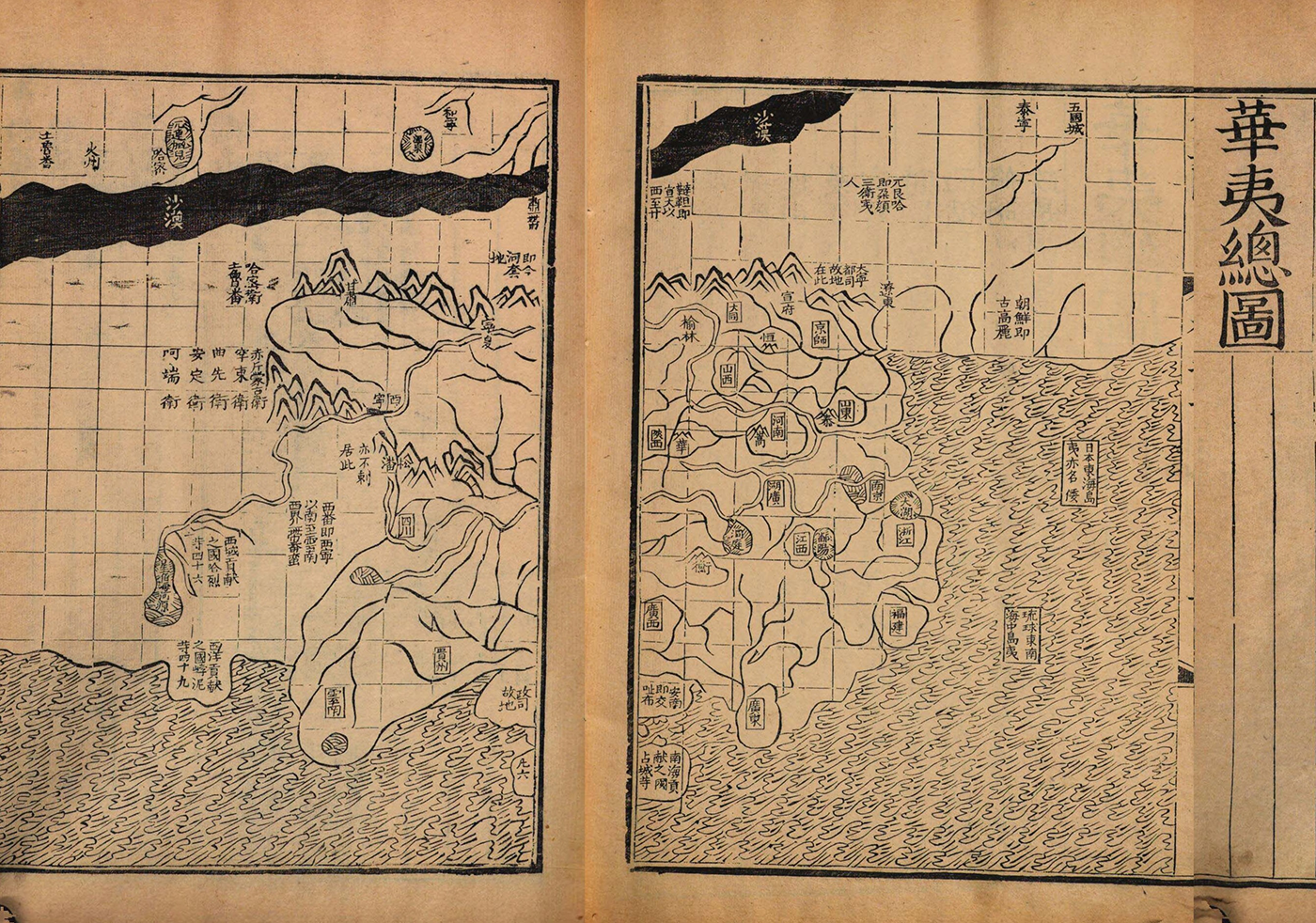
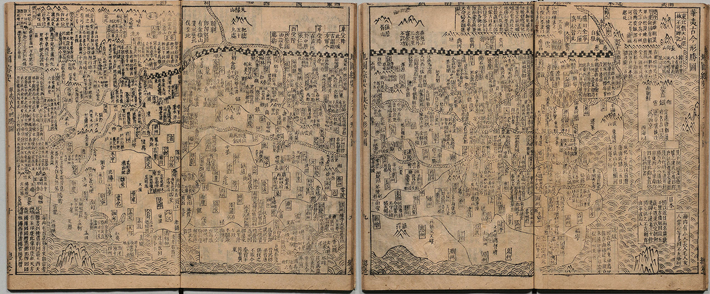
To emphasize that their maps showed regions further away, Ming mapmakers used other terms. One concept that was popular before the transition to the Qing was that of huayi: the ‘civilized’ contrasted with the ‘barbarian’, a term which appears in the titles of maps as early as the twelfth century.Footnote 20 The 1579 edition and the 1799 reissue of the popular atlas Guang yutu 廣輿圖 (Extended territorial maps) include a map titled ‘Huayi zongtu’ 華夷總圖 (Complete map of the civilized and the barbarian; Figure 4), showing China at the centre.Footnote 21 With a few exceptions, such as Japan, Korea, and the Mongols, non-Chinese regions and peoples are not named individually but grouped together. The map states, for example: ‘The tribute bringing countries in the Western Ocean like Boni [Brunei] etc., 49 [in total]’ 西洋貢獻之國㟑泥等四十九. Although at first glance, the geographic space on ‘Huayi zongtu’ and ‘Da Ming yitong zhi tu’ looks the same, in grouping and naming all the non-Chinese countries, the geographic extent of the 1579/1799 map broadened. The map provides a visual index of all non-Chinese people mentioned on the pages that follow the map. The title here clearly advertises the contents and showcases that this map shows more than the Ming empire. The ‘Huayi gujin xingsheng (zhi) tu’ 華夷古今形勝(之)圖 (Map of advantageous terrains of the civilized and the barbarian then and now) in Zhang Huang’s 章潢 (1527–1608) encyclopedia Tushu bian 圖書編 (Compendium of illustrations and writings, 1613) and in a nearly identical configuration in the Ditu zongyao extends the geographic boundaries even further (Figure 5).Footnote 22 Although it still groups countries together, it names more and further away places, including India, Arabia, and Java, and provides brief descriptions of several of these places. These huayi maps present a view of the extent of the world popular in Ming writings, focusing on countries that had official relations with the Ming state.Footnote 23
‘Huayi zongtu’ in the 1799 edition of the Guang yutu, which closely models the 1579 edition. This map shows the geography of the Ming and summarizes several non-Chinese countries and regions surrounding China. The title of the map is on the previous page. Height of paper circa 35.5 cm. Digitally assembled. Source: Nationalbibliothek Wien, Vienna, Austria.
‘Huayi gujin xingsheng tu’ in Ditu zongyao (1644). This map shows China at the centre surrounded by annotations of non-Chinese countries and regions. Height of paper circa 26 cm. Source: National Archives of Japan, Tokyo, Japan.
Huayi in combination with sihai, the four seas, also appears as the main descriptive terms on a Buddhist world map. Titled ‘Sihai huayi zongtu’ 四海華夷總圖 (Complete map of the four seas and the civilized and the barbarian; Figure 6), it shows India at the centre on the same landmass as China, surrounded by several islands.Footnote 24 A note in the corner of the sheet explains that the map depicts the continent of Jambudvīpa (Nanzhanbuzhou 南瞻部州), which is in the middle of the four seas (sihai). India takes up most of the space, with China only a small section of the continent, making this an unconventional map of the depiction of huayi, as the hua is decentred. The ‘Sihai huayi zongtu’ is not the only nor the earliest Buddhist map with a similar configuration of the continents, but the title is unusual and brings the Buddhist world view closer to a China-centred one, even though the mapmaker did not follow through graphically, thus somewhat disconnecting the title from the contents.Footnote 25 All these huayi maps focus essentially on showing China in association with other places in Asia that had direct contact with the Ming state through political or religious connections.
‘Sihai huayi zongtu’ in Tushu bian (1613). A Buddhist world map depicting the continent of Jambudvīpa with India at its centre and China at the margin, surrounded by islands of other countries. Height of paper circa 27 cm. Source: Harvard-Yenching Library, Cambridge, MA, United States of America.

Mapping lands far away
At the same time that these tianxia and huayi maps were made, Ming mapmakers created comprehensive maps that depicted places further away. During the early Ming, maps that show Africa and Europe incorporated knowledge gained during the Mongol Yuan empire.Footnote 26 European maritime expansion in the sixteenth century took the geographical understanding of the world beyond the regions that had hitherto been mapped. China connected to trade networks that spanned the entire globe, west via the Indian Ocean and east over the Pacific via Manila. With these expanding global networks, the number of countries and peoples to be mapped and written about grew as well. From the late sixteenth century onwards, Chinese scholars took part in creating maps that show not only a Sinocentric Asia, but also Europe, Africa, and the Americas together. With this expanded view, new terms appeared in the titles of world maps, most notably wanguo, kunyu 坤輿 (earth), and diqiu 地球 (globe).
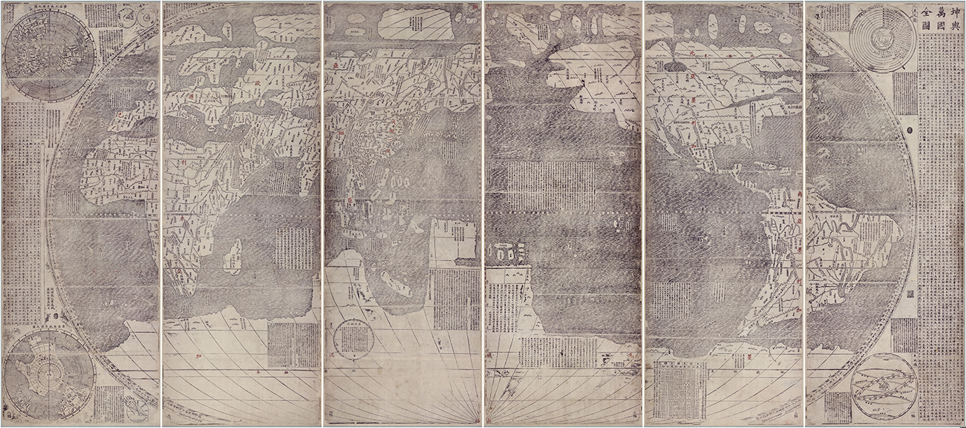
Like huayi, wanguo refers to the countries and people shown on the map. Literally, it means 10,000 countries, but stands for ‘all’ countries, and had already been used in Chinese writings for centuries, before appearing in the title of maps. The most prominent example of such a map is the Kunyu wanguo quantu 坤輿萬國全圖 (Complete map of all countries on earth) by Matteo Ricci (1552–1610), Li Zhizao 李之藻 (1565–1630), and others, printed in Beijing in 1602. It is a world map that combines Renaissance and Chinese knowledge of world geography and shows Europe, Asia, Africa, the Americas, and the imaginary southern continent Magellanica (Figure 7). Likewise, the ‘Wanguo quantu’ 萬國全圖 (Complete map of all countries), published in Giulio Aleni (1582–1649) and Yang Tingyun’s 楊廷筠 (1557–1627) Zhifang waiji 職方外紀 (Record of everything beyond the administration, 1623), shows the same configuration of landmasses as the Kunyu wanguo quantu and uses the term wanguo to highlight the wide-reaching extent of the space shown on the map (Figure 8). On the 1602 map, however, wanguo is not the only term to advertise the far-reaching extent of space, but it is combined with the term kunyu.
Kunyu wanguo quantu, Beijing, 1602, circa 161 × 371 cm. Source: Miyagi Prefectural Library, Sendai, Japan.
‘Wanguo quantu’ in Zhifang waiji (1623). Height of paper circa 25.5 cm. Digitally assembled. Source: National Archives of Japan, Tokyo, Japan.
Kunyu refers to the whole globe and appears not only on the Kunyu wanguo quantu but also consistently on seventeenth- and eighteenth-century world maps made with the involvement of Jesuits, three of which bear the title Kunyu quantu 坤輿全圖 (Complete map of the earth).Footnote 27 The term kunyu needs some further explanation. Kun is one of the eight trigrams and represents earth. Jesuits used kun in combination with the first trigram qian 乾 (representing heaven), as in qiankun 乾坤, to translate the Catholic vision of ‘universe’. Like kun, yu 輿 means ‘earth’, especially in connection with the character di 地, either as diyu 地輿 or yudi 輿地. By combining kun and yu, the term signifies earth as opposed to the heaven, encompassing all of planet Earth. This is not a new combination, as the term kunyu has been used at least since the seventh century,Footnote 28 but only in the seventeenth century does it appear in titles of maps. The title Kunyu wanguo quantu is possibly closely modelled after that of Abraham Ortelius’s (1527–1598) world map ‘Typus orbis terrarum’ (Image of the lands of the globe) in his atlas Thetrum orbis terrarum (Display of the lands of the globe; first edition 1570), copies of which Ricci had with him in China, and which served as one of the sources for the Kunyu wanguo quantu. Footnote 29
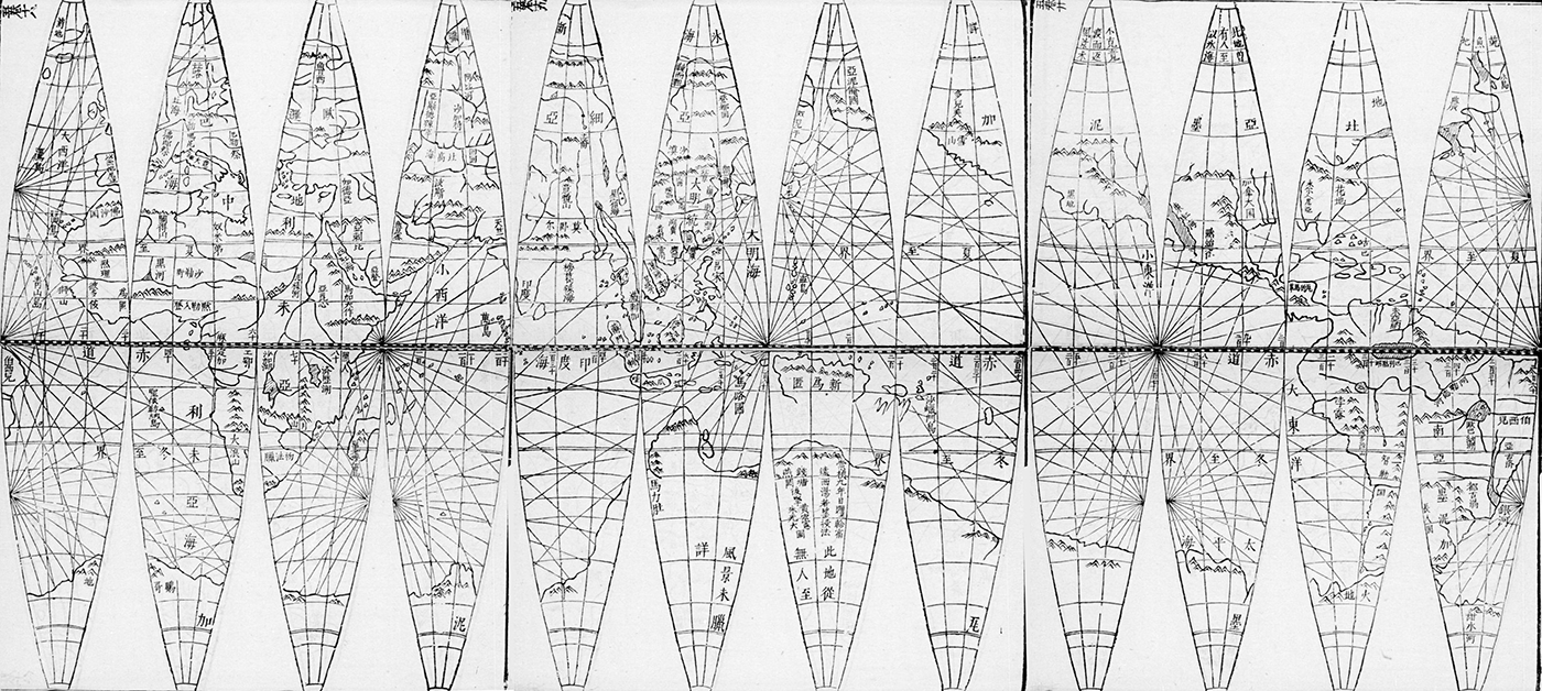
Direct comparison between the ‘Wanguo quantu’ (Figure 8) and the Kunyu wanguo quantu (Figure 7) reveals a further dimension of the term kunyu. The margins of the Kunyu wanguo quantu are filled with information about the earth’s sphericity and the heavenly bodies. This cosmological dimension is missing from the ‘Wanguo quantu’ but we can find it in the three Kunyu quantu. The term kunyu advertised the contents of the maps as something more extensive, going beyond the simple geography of the earth. Diqiu fulfilled a similar function. This term, literally referring to the terrestrial globe, or its slight variation dadi yuanqiu 大地圓球 (spherical earth) appears in the title of a few seventeenth- and eighteenth-century maps and prints of globe gores such as the 1636 globe by Adam Schall von Bell (1591–1666), Huang Hongxian 黃宏憲, and Zhu Guangda 朱光大 (Figure 9).Footnote 30 These artefacts all embed the image of earth with astronomical information, thus also providing a cosmological dimension.Footnote 31
‘Diqiu shi’er changyuan xing tu’ 地球十二長圓形圖 (Map of the terrestrial globe in twelve oval pieces) in Huntian yishuo 渾天儀說. Gores of a terrestrial globe. The gores span over three folios, digitally assembled. Source: Gallica/Bibliothèque nationale de France, Paris, France.
In the decades that followed the publication of the Kunyu wanguo quantu, wanguo and kunyu appeared on maps made without any direct involvement of the Jesuits.Footnote 32 However, the mapmakers did not necessarily keep the cosmological implications of the term kunyu Footnote 33 nor did they follow the configuration of continents as on the Kunyu wanguo quantu and ‘Wanguo quantu’. An otherwise unknown teacher by the name of Liang Zhou 梁輈 made a map titled Qiankun wanguo quantu gujin renwu shiji 乾坤萬國全圖古今人物事跡 (Complete map of all countries of heaven and earth, with famous persons and important events then and now, 1603?) which, like the earlier huayi maps, shows a large China at the centre surrounded by annotations of non-Chinese regions, which extend as far west as India and Mecca in Asia, as well as the Americas and Magellanica.Footnote 34 The similarity in title to the Kunyu wanguo quantu is no coincidence: place names of non-Chinese regions were taken from the 1602 map.Footnote 35 With the term wanguo in the title, Liang Zhou expanded the extent of the geographic space mapped without copying strictly from the Kunyu wanguo quantu and without necessarily considering the shape of the continents. To Chinese scholars, the terms wanguo and kunyu therefore represented ways of extending the mapped world compared to contemporary maps of tianxia, huayi, or the Ming empire, but usage of these terms did not necessitate emulating every aspect of Renaissance mapmaking practices.
For most of the eighteenth century, no maps with wanguo in the title seem to have been produced. Only in the final decade was such a map created again: Zhuang Tingfu’s 莊廷旉 Da Qing tongshu zhigong wanguo jingwei diqiu shi fangyu gujin tu 大清統屬職貢萬國經緯地球式方輿古今圖 (Map of the earth then and now, showing the great Qing, all countries bringing tribute and the globe according to longitude and latitude) with editions extant from 1794 and 1800 (Figure 10).Footnote 36 The map shows two hemispheres: Eurasia-Africa and Australia on the right and the Americas on the left; the oceans are filled with lines connecting places. Zhuang Tingfu commented on other countries bringing tribute to the Qing court, emphasizing China’s central role and connection to the world, mirroring the connected nature of the mapped oceanic space. In the seventeenth and then again in the late eighteenth centuries, the term wanguo was consistently used in titles to advertise artefacts that mapped the Americas and other places far from China. Furthermore, on Zhuang Tingfu’s late eighteenth-century map, the term wanguo displayed an even more cosmopolitan vision in that it showed a world connected by lines.
Zhuang Tingfu’s Da Qing tongshu zhigong wanguo jingwei diqiu shi fangyu gujin tu (1800). 60 × 93 cm. Source: MacLean Collection, MC29773, Illinois, United States of America.

Not all titles of maps that show this global image of the world make a claim to comprehensiveness. In 1603, Ricci and Li Yingshi 李應試 (1559–1620?) printed a map, titled Liangyi xuanlan tu 兩儀玄覽圖 (Mysterious visual map of the two forms), the configuration of which resembles the Kunyu wanguo quantu. This title does not use any of the terms such as wanguo, tianxia, or kunyu. Several world maps in Ming geographies that show the Americas are titled ‘Shanhai yudi quantu’ 山海輿地全圖 (Complete map of mountains, seas, and lands) or, in a rare example, just ‘Yudi quantu’ 輿地全圖 (Complete map of the lands). The map titled ‘Shanhai yudi quantu’, which first appeared in a printed book in 1602, served to illustrate the world in subsequent works throughout the seventeenth and eighteenth centuries, both in books and on sheet maps.Footnote 37 From the seventeenth century onwards, world maps that showed the Americas, among other places, were therefore using the terms wanguo, diqiu, and kunyu to emphasize their comprehensiveness, but certainly not all such maps employed these terms.
Expanding tianxia and sihai
Although most maps from the time around the Ming-Qing transition with the term tianxia in their titles equated tianxia with the Ming empire, at first glance two related, commercial publications from this period appear to expand the scope of tianxia. They combine a Sinocentric vision of the world with a depiction of Europe, the Americas, Africa, and Magellanica mapped at the margins, with the title including the term tianxia (Figure 11). The first one is a single sheet published by Cao Junyi 曹君義 in 1644, with the title Tianxia jiubian fenye renji lucheng quantu 天下九邊分野人跡路程全圖 (Complete map of tianxia, the nine frontiers, astral allocations, human traces, and route itineraries) appearing in large characters in the top.Footnote 38 The artefact is divided into multiple parts. The world map, combining elements from a map of the Ming empire and the ‘Wanguo quantu’ (Figure 8), occupies the centre. Textual elements surround it on all sides. In the upper register, a preface titled ‘Wanguo da quantu shuo’ 萬國大全圖說 (Explanation of the large complete map of all countries) provides an alternative title, highlighting that the map is one of wanguo.Footnote 39 In the lower register, the use of the term tianxia is reserved for Chinese provinces: a section titled ‘Tianxia liangjing shisansheng fuzhouxian lucheng’ 天下兩京十三省府州縣路程 (An itinerary of the two capitals, thirteen provinces, prefectures, sub-prefectures, and counties of tianxia) gives information on distances between administrative units of the Ming empire. The part to the right of the map further explains the geography of the frontier region north of the Ming empire named ‘Nine frontiers’ (jiubian), while the register on the left lists foreign countries under the heading waiguo 外國 (literally ‘outer countries’). Although the map shows Europe, Africa, and the Americas, no country from these continents appears in the list of waiguo. These textual elements around the map clarify several points: the map is one of wanguo; the Americas are part of wanguo; tianxia only extends over the geography of the Ming. The title Tianxia jiubian fenye renji lucheng quantu therefore applies to the whole artefact and not just the map on it.
Wang Junfu’s Tianxia jiubian wanguo renji lucheng quantu (1663). 125 × 123 cm. Source: Yokohama City University Library, Yokohama, Japan.
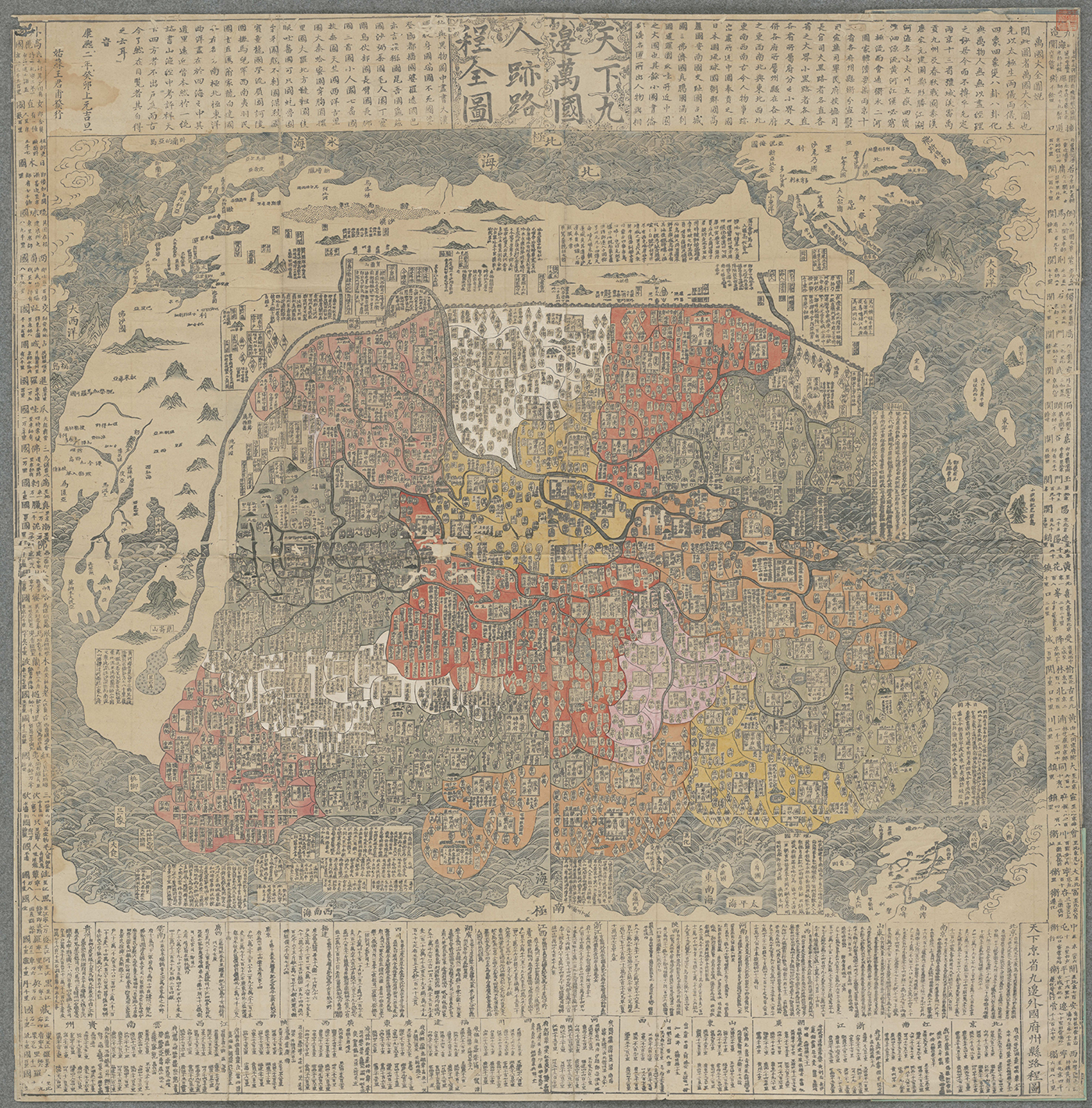
The importance of the term wanguo in the title is further emphasized by a map published in 1663 by Wang Junfu 王君甫 that is similar in many respects to Cao Junyi’s map. While keeping the geographic scope, configuration, and textual elements the same, the title of Wang’s artefact is changed to Tianxia jiubian wanguo renji lucheng quantu 天下九邊萬國人跡路程全圖 (Complete map of tianxia, the nine frontiers, all countries, traces of human presence, and itineraries; Figure 11), thus replacing fenye (astral allocations) with wanguo. Wang Junfu’s title reflects three of the four textual elements in the margins of the artefact. Although these two artefacts use the term tianxia in the title, it was wanguo that was the key term indicating the mapping of non-Chinese regions far away from Ming or Qing China. As in the case of Liang Zhou, mapping these far away regions under the umbrella of wanguo did not imply strictly following the shape of the continents of earlier maps.
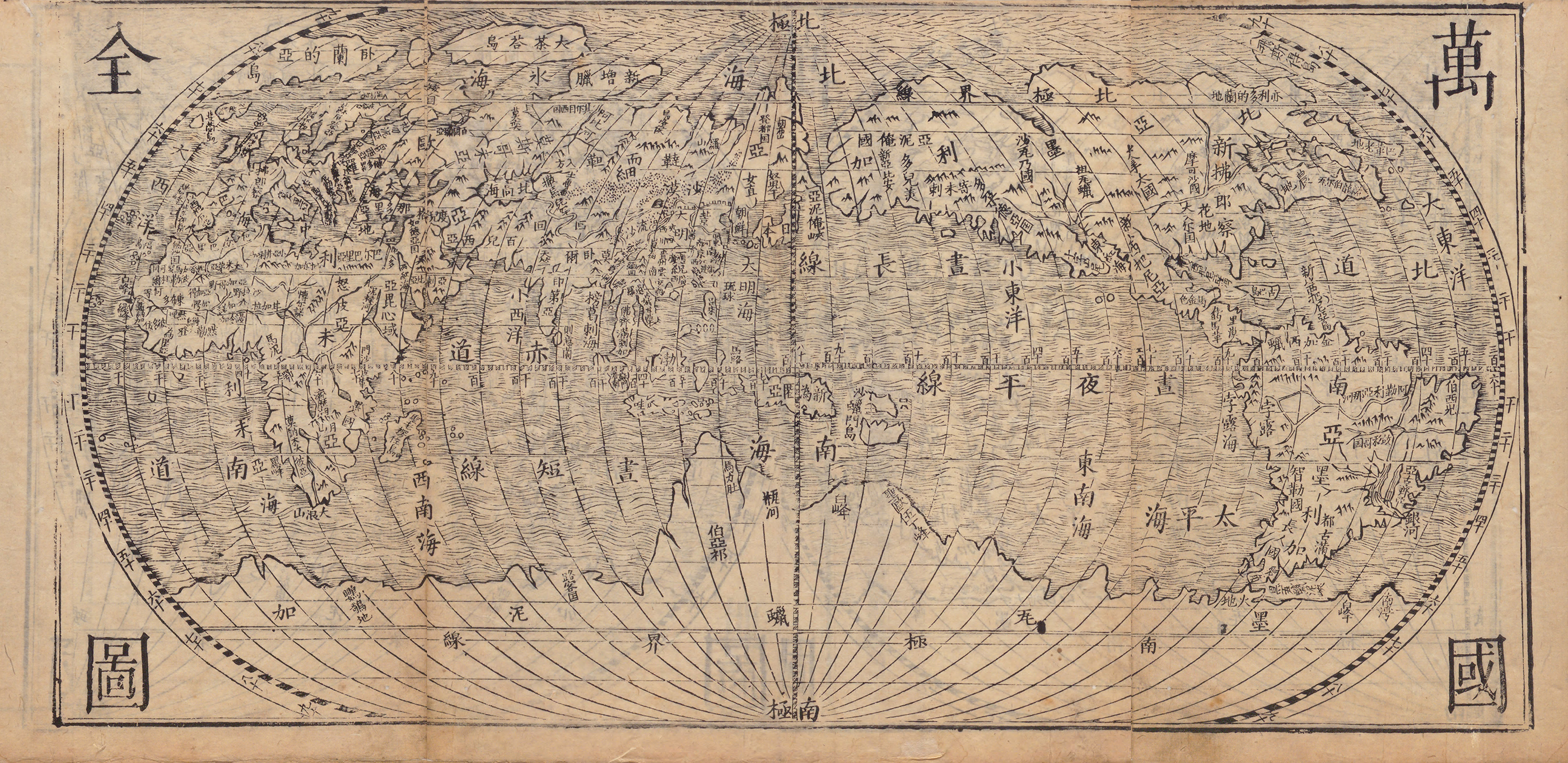
In the eighteenth century, mapmakers expanded the scope of tianxia to follow political circumstances, using it to define a new cosmopolitan vision of the Qing empire. When the Tushu bian was republished in the late eighteenth century as part of the imperial collection Siku quanshu 四庫全書, the editors changed the title of the ‘Huayi gujin xingsheng zhi tu’ discussed above to ‘Gujin tianxia xingsheng zhi tu’ 古今天下形勝之圖 (Map of advantageous terrains of tianxia then and now).Footnote 40 Now that Manchus ruled China, the concept of huayi had become outdated, and so a new term needed to be found for the title of the map.Footnote 41 This expanded the scope of tianxia to encompass not only the Ming and Qing empire, but also many of its neighbours. Furthermore, maps of a series, of which most bear the title Da Qing (wannian) yitong tianxia quantu 大清(萬年)一統天下全圖 (Complete map of the (everlasting), unified great Qing of tianxia), exist in multiple iterations, the earliest extant one dating to 1714.Footnote 42 These maps therefore appeared a few decades after Taiwan and shortly after Outer Mongolia had become part of the Qing empire. This fact is alluded to in the first sentence of a short note on the 1714 map: ‘The expanse of the territory of the present dynasty is unprecedented’ 本朝幅員之廣亘古未有. The extent mapped went even beyond the new conquests: the 1714 map mentions several countries in the maritime space south and east of the Qing empire. Eleven years later, in 1725, Wang Ri’ang 汪日昂 extended tianxia even further on a map with the same title (Figure 12). In the map’s upper left corner, a small ocean includes several islands that designate European countries (for example, Helan 荷蘭, ‘Holland’ and Ganxila 干系臘, ‘Castille’). These additions reflect the importance of relations between the Qing empire and these places. Furthermore, on the 1725 map, the islands south and east of China are now connected by lines to the Qing state.Footnote 43
Wang Ri’ang’s Tianxia yitong tianxia quantu (1724). 138 × 117cm. Source: Kyujanggak Institute for Korean Studies, Seoul National University, Seoul, Korea.
The lines that connect the Qing empire with Southeast Asia on the 1725 map have their origins in a political debate that took place during the last years of the reign of the Kangxi emperor (r. 1661–1722). In 1717, the emperor had banned trade between the Qing empire and Southeast Asia, a ban that was not popular among his officials. To convince the emperor to lift it, the naval commander of Fujian Shi Shipiao 施世驃 (1667–1721) presented him with a map of Southeast Asia that showed the Qing empire clearly connected by lines with the maritime world, highlighting how the Qing empire relied on trade and connections.Footnote 44 This cosmopolitan vision of the Qing empire was then picked up by Wang Ri’ang in his 1725 map, and became the most popular depiction of the Qing empire until at least the mid-nineteenth century, with multiple commercially published maps adapting this spatial configuration with the title Da Qing (wannian) yitong tianxia quantu.Footnote 45 They show that tianxia was the Qing empire surrounded by its closest neighbours.
During the Ming, these tianxia maps showed overlapping concepts of geographical space as understood by the Ming court, scholars, and commercial publishers. During the Qing, however, these concepts diverged. The Da Qing (wannian) yitong tianxia quantu do not represent the way the Manchu court understood and mapped the empire. We can observe the court’s vision in the three extensive mapping projects of the eighteenth century, in Chinese titled Huangyu quanlan tu 皇輿全覽圖 (Overview maps of imperial territories) partly based on extensive land surveys.Footnote 46 Although the maps resulting from these projects also extended the geographic space beyond the strict boundaries of the Qing empire, they focus on continental space and on representing this space in as much detail as possible. From the late eighteenth century onwards, court maps also started to show the boundaries of the Qing empire.Footnote 47 On all the Da Qing (wannian) yitong tianxia quantu, however, the exact extent of the Qing empire remained undefined. None of these maps marks the political borders of the empire, and only the desert strip serves somewhat as the only visual, cultural boundary.Footnote 48
Early eighteenth-century scholars not only reconsidered mapping tianxia, but also the extent of sihai. In 1730, Chen Lunjiong 陳倫烱 completed a book about the maritime world based on what his father had learnt on his travels in Southeast Asia. This Haiguo wenjian lu 海國聞見錄 (Things heard and seen about maritime countries, published in 1744) includes one hemisphere of a world map titled ‘Sihai zongtu’ 四海總圖 (Complete map of the four seas).Footnote 49 The map shows Europe, Africa, and Australia. A few decades later, a certain Ma Junliang 馬俊良 would explain that the second hemisphere was missing because the Haiguo wenjian lu was based on personal travel accounts.Footnote 50 Like the sihai map from the Ming, Chen Lunjiong’s map focused on the connected Eurasian landmass. It only expanded on the sihai map slightly but does not cover the whole globe (although one could argue that he did indeed map all the oceans). Although eighteenth-century mapmakers used the same terms as their Ming predecessors, for them the scope of tianxia, wanguo, and sihai expanded, serving to contextualize the Qing in the wider world.
Combining maps and terms
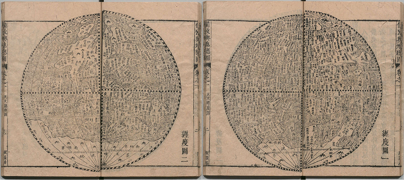
The extent of what constitutes tianxia can best be grasped when looking at artefacts that combine a map of tianxia with other maps. Several seventeenth-century books do just that. Although in the eighteenth century, tianxia had become a replacement for the term huayi, in the 1640s, scholars still distinguished between the two terms. The Ditu zongyao starts with the huayi map discussed above (Figure 5), followed by maps of tianxia that show essentially the Ming and include barely any non-Chinese place names. Published only a decade earlier, the Huiji yutu beikao makes a similar distinction between tianxia and the wider world. The first map in this work is a map of the world in two hemispheres (Figure 13).Footnote 51 This map is followed by the map of China titled ‘Tianxia zongtu’ (Figure 1), after which the book’s creators inserted maps of every Chinese province. The maps are arranged from the largest to the smallest, indicating that the geographic space of the subsequent maps is part of the previous one. The two-hemisphere map encompasses tianxia but shows much more.
The ‘Chandu tu’ in Huiji yutu beikao quantu (1633) showing the Americas. The map is followed by the ‘Tianxia zongtu’ (Figure 1). Source: National Archives of Japan, Tokyo, Japan.
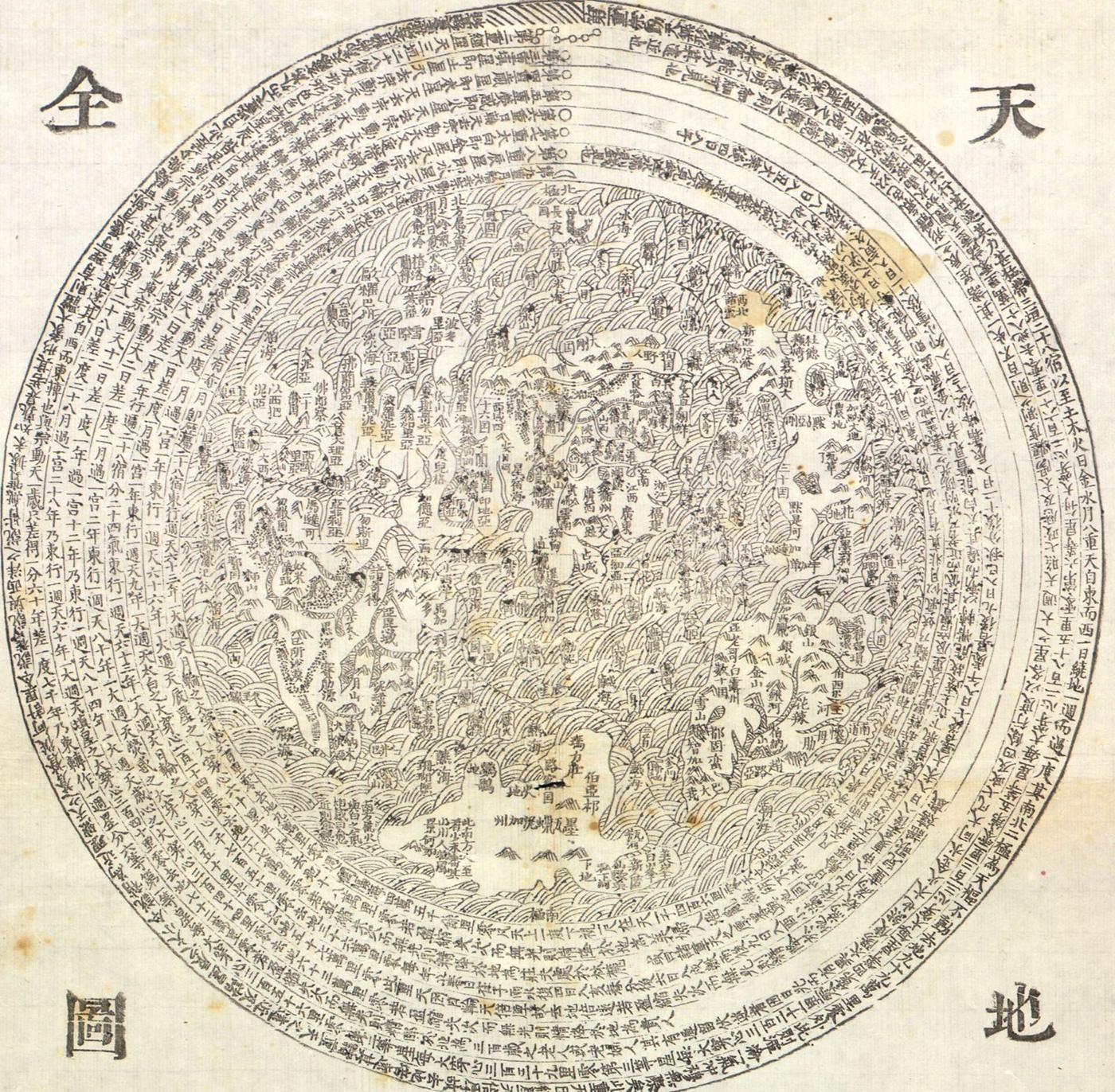
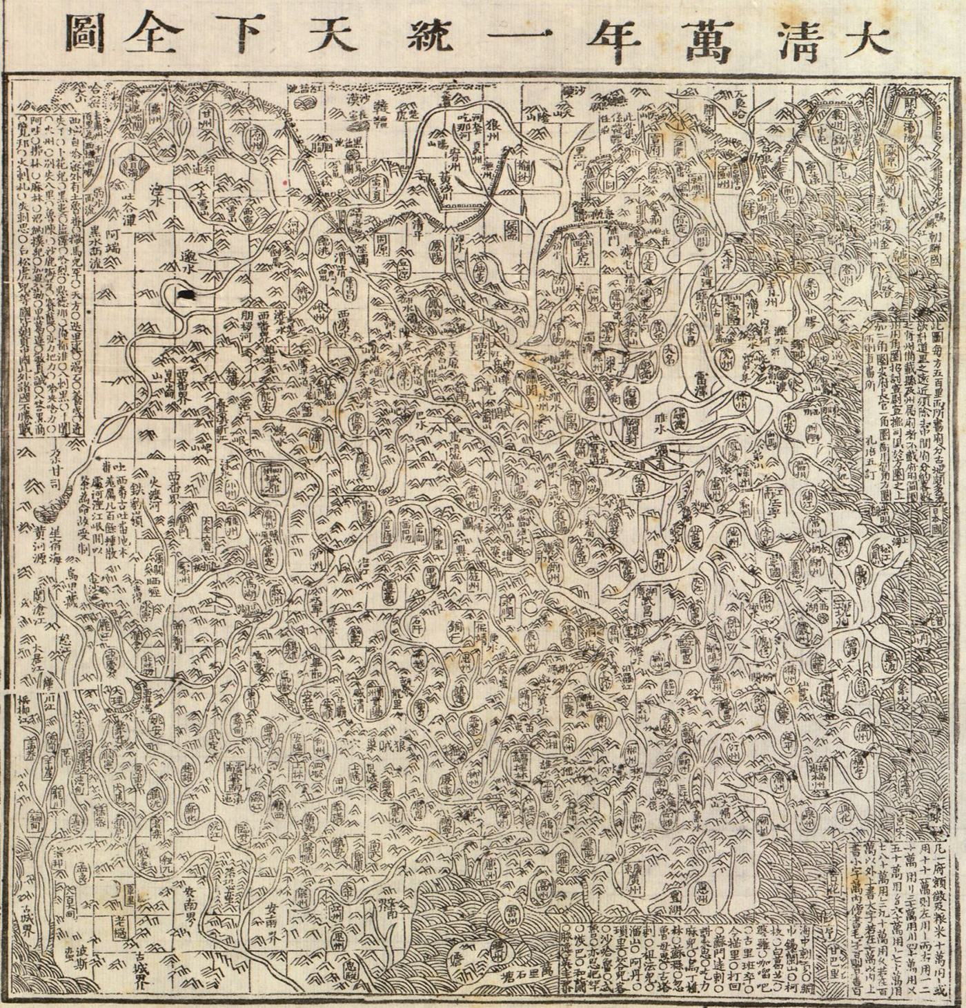
This idea that tianxia was only a part of a more extensive world is not unique to these seventeenth-century works but can also be gleaned from eighteenth-century sources. One example is the 1722 Sancai yiguan tu 三才一貫圖 (Aligned illustration of the three powers [i.e. heaven, earth, humankind]), an artefact combining multiple maps, illustrations, and textual elements on one sheet of paper (see Figures 14–16).Footnote 52 At the top of the sheet is a circular world map titled ‘Tiandi quantu’ 天地全圖 (Complete map of heaven and earth) showing Eurasia, Africa, the Americas, and Magellanica. To this map’s lower left is a square map titled ‘Da Qing wannian yitong tianxia quantu’ showing the Qing empire and a few islands in the sea. By labelling the map of the Qing empire as a map of tianxia but giving the map showing Europe, Africa, and the Americas a different title, the designers of the Sancai yiguan tu made it clear that these faraway continents were not part of tianxia. In his Haiguo wenjian lu Chen Lunjiong makes a similar distinction. Only the geography of the coast of China is described under the term tianxia; for everything beyond, he uses terms such as dongyang 東洋 (eastern ocean) or nanyang 南洋 (southern ocean).Footnote 53 His ‘Sihai zongtu’, showing all of Asia, Africa, and Europe, is a map inclusive of tianxia but not of tianxia. In essence, all these artefacts show that tianxia was only part of a wider world—a wider world that in many cases included the Americas and other faraway parts of the world.Footnote 54
Sancai yiguan tu (1722). 155 × 89 cm. Source: Library of Congress, Geography and Map Division, Washington, DC, United States of America.
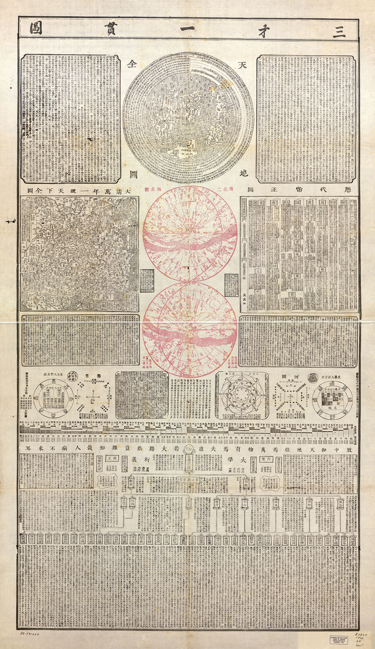
‘Tiandi quantu’ on the Sancai yiguan tu (Figure 14).
‘Da Qing wannian yitong tianxia quantu’ on the Sancai yiguan tu (Figure 14).
While the titles of seventeenth- and eighteenth-century maps co-authored by Jesuits do not use the term tianxia to showcase a global outlook, works (co-)written by Jesuits still engaged with the term tianxia. From the sixteenth century, we have examples of the translation of the term tianxia into Latin varying between designating the whole globe (orbis terrarum) and China (regnum, locus regius) in a single document. However, seventeenth- and eighteenth-century geographical sources use tianxia to mean the whole globe.Footnote 55 The Zhifang waiji for example, starts the chapters on Asia, Europe, and Africa with a statement about the continents being part of tianxia (‘Asia is a continent of tianxia’ 亞細亞者天下一大州也; ‘The name of the second continent of tianxia is Europe’ 天下第二大州名曰歐羅巴; ‘The third continent of tianxia is called Libya [Africa]’ 天下第三大州曰利未亞). The description of America is less clear, as the text does not mention tianxia in the first introductory sentence: ‘America is the general name for the fourth continent’ 亞墨利加第四大州總名也.Footnote 56 However, according to the rest of the description, America is clearly part of tianxia as well. Aleni and Yang even go as far as to state: ‘The area [of the Americas] is extremely extensive, they share an equal half of tianxia’ 地方極光平分天下之半.Footnote 57 Verbiest’s geography book also includes several sections where tianxia is described as the equivalent of the whole globe.Footnote 58 In these Jesuit co-authored works, the Americas clearly belonged to tianxia.
Later Chinese scholars throughout the seventeenth and eighteenth centuries who read and reworked the Zhifang waiji tended to avoid the book’s frequent use of tianxia. Xiong Renlin 熊人霖 (1604–1667), for example, drawing from the Zhifang waiji in his own world geography, starts the description of each continent in a similar manner to the earlier text. He writes that ‘Dazhanna [Asia] is the first continent of tianxia 大瞻納者天下一大州也’. For all other continents, however, he avoids the term tianxia, only stating at the beginning of the chapters ‘the second continent is called Europe 次二之州曰歐羅巴’, ‘the third is called the continent of Africa 次三曰利未亞之州’, and ‘the fourth is called the continent of America 次四曰亞墨利加之州’, despite the Zhifang waiji having clearly labelled Europe and Africa as continents of tianxia.Footnote 59 Although Xiong Renlin did not remove all references to tianxia, this rephrasing nevertheless shows a reluctance to extend tianxia to all continents.Footnote 60 Other scholars were more drastic in their rebuttal of the expansion of tianxia to include the whole known world: Chen Zushou 陳組綬 argues against the idea of China being one small country among many. He particularly takes issue with the claim of tianxia consisting of five continents, explaining that all of tianxia belongs to the Ming emperor.Footnote 61 And while the editors of the Siku quanshu tiyao had summarized the Zhifang waiji, claiming that ‘tianxia is divided into five continents 分天下為五大洲’, in the eighteenth century, Zhuang Tingfu slightly changed the wording to say: ‘yudi (earth) is divided into five continents 分輿地爲五大洲’ in the introduction to his map.Footnote 62 All these artefacts show that geographical texts co-authored by Jesuits describe tianxia as being equivalent to the whole globe—the orbis terrarum—while Ming and Qing scholars presented tianxia as only a part of the greater world.
Conclusion: Where is tianxia?
Looking at maps with the term tianxia in the title allows us to reconstruct Chinese ideas of cosmopolitanism. Tianxia implies a certain idea of cosmopolitanism—the idea that everything is connected ‘under heaven’ with China at the centre. What constitutes ‘everything’ is ambiguous. By looking at maps, we can address the question of the location of tianxia. The maps discussed in this article reveal a shift in meaning. The political uncertainties and the change of power in the mid-seventeenth century, both before and after the Qing conquest of Beijing, reinforced the idea that tianxia was geographically the same as the Ming empire. The Qing empire expanded from the late seventeenth century onwards, and so did tianxia. At this point, tianxia was not equivalent to the extent of the empire: it included places further away in Europe and Southeast Asia. It remained, however, a clearly hierarchical way of representing the world: the Qing empire was the centre and the largest area on the maps. Jesuits, on the other hand, had a broader concept of the meaning of tianxia; in their writing, they included under tianxia the whole globe, as they knew it. However, this usage is not reflected in the maps they (co)authored, and neither was it followed by most Ming and Qing writers. The Americas, Africa, and Australia were not part of Chinese scholars' mapped tianxia.
Instead, these continents appear in maps with titles including terms like wanguo and kunyu. The creation of many of these world maps and the application of these terms in the titles were cosmopolitan processes. Ricci, Aleni, and Schall von Bell could not have produced these maps without Li Zhizao, Yang Tingyun, Huang Honxian, and Zhu Guangda who are explicitly credited in the artefacts, as well as the many uncredited helpers. Neither wanguo nor kunyu were terms invented in the seventeenth century, but they turned out to be fitting descriptors of the contents of the artefacts and it was this cooperation that led to the terms appearing in titles. Chinese scholars followed in the footsteps of these concretely cosmopolitan processes of mapmaking, resulting in expressions that showcased ideas of cosmopolitanism and the inclusion of faraway places by keeping the terms wanguo and kunyu. However, this does not mean that mapmakers followed the configurations of continents of the collaborative maps. Ideas of an ever-expanding world and the existence of the Americas could be included in Ming and Qing maps without having to comply with every aspect of Renaissance mapping. Aside from the difference in the understanding of the extent of tianxia between Jesuits and Chinese scholars, the ideas of the geographic extent of tianxia, wanguo, and kunyu are extremely consistent throughout the whole corpus of Ming and Qing maps that I examined, regardless of the materiality of the map, origins of the author, or printing place.
In Korea and Japan, mapmakers produced a wide range of maps with titles in Chinese characters that use the terms tianxia (K. cheonha, J. tenka) and wanguo (K. manguk, J. bankoku). However, the usage of these words differed significantly from that of Ming and Qing China. In Joseon Korea, the term cheonha was employed much more frequently but less consistently. It could designate a map of the Chinese state surrounded by neighbouring countries, but it could also be the title of a world map in Korean atlases. These Cheonha do atlas maps form their own genre of world maps, drawing the continent in a circular shape surrounded by another ring of landmass. They are particular to Korean mapping. Some Korean atlases replaced these maps with configuration of landmasses taken from the ‘Shanhai yudi quantu’ or the ‘Wanguo quantu’.Footnote 63 In Korea, the Americas could thus be part of tianxia/cheonha. In Japan, on the other hand, the term tenka hardly made it onto any maps, and Japanese mapmakers even replaced it when replicating Chinese maps.Footnote 64 Instead, the term bankoku became an important concept. While Chinese mapmakers used the term sparingly and did not have a consistent way to identify maps that showed the Americas, nearly all world maps produced in the seventeenth to mid-nineteenth centuries in Japan do so.Footnote 65 Bankoku was even used in the title of Buddhist world maps.Footnote 66 Despite a rich exchange of maps between China, Korea, and Japan, terms and concepts were not necessarily preserved when moving from one region to another.
Tianxia maps have been presented as evidence that Qing mapmakers did not pay attention to, or were ignorant of, places far away. However, I would like to propose the opposite: these maps are evidence of a cosmopolitan Qing empire, an empire that was without doubt connected to other parts of the world, as the lines in the ocean very explicitly show. Regions further away were not mapped because they were not part of tianxia, but many mapmakers were well aware of their existence and made a conscious choice not to include them within tianxia, as the artefacts combining multiple maps show. The Americas might not have been part of tianxia, but this does not mean they were not part of the world and known space of the collective knowledge of Ming and Qing scholars. On these maps, tianxia is cosmopolitan not because it designates the whole known world, but because it shows the Qing empire connected to other parts of the world.
Acknowledgements
I would like to thank Annie Chan and Pamela Kyle Crossley for their careful editing of this article which helped me to refine my argument. Furthermore, I am grateful to Mario Cams and the members of the Early Modern History reading group at KU Leuven who read and commented on an earlier draft.
Funding statement
This research was supported by and contributes to the ERC AdG project TRANSPACIFIC, which has received funding from the European Research Council (ERC) under the European Union’s Horizon 2020 Research and Innovation Programme (Grant agreement No. 833143).
Competing interests
The author declares none.


 Open access