
The harvest of old ages
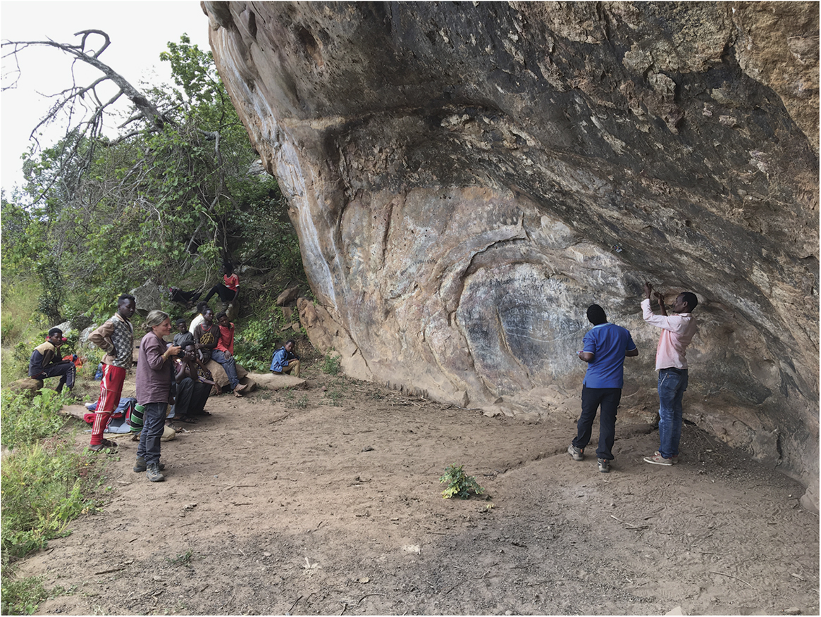
Surveying rock art at the Borema rockshelter, Yabelo, Borana Zone, Oromia Region, Ethiopia. Holocene rock art galleries are common in Ethiopia. The ‘(H)origin Project’ of the University of Rome La Sapienza—in collaboration with the University of Milan, the Ethiopian Authority for Research and Conservation of Cultural Heritage, and the Borana Zone Culture and Tourism Office—is investigating the Yabelo area with the participation of local communities, combining archaeological research and conservation. Paintings are recorded with highly accurate digital technologies, and chemical-physical analyses of pigments and rock micro-samples are supporting work to preserve the art. A key aim of the project is to enhance the local population’s awareness of rock art, and to develop sustainable tourism. Photograph: Marina Gallinaro and Andrea Zerboni.
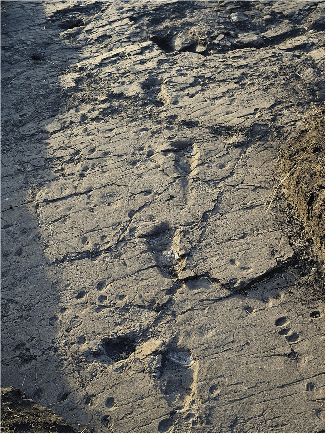
In 1978, Mary Leakey and her collaborators discovered the footprints of three bipedal hominins in a palaeosurface (site G) at Laetoli in northern Tanzania. These were dated to 3.66 million years and attributed to Australopithecus afarensis. In 2014–2015, three test pits (site S) were excavated 150m to the south of site G revealing new tracks—illustrated here—related to two hominins (S1 and S2) moving across the same palaeosurface and in the same direction as the three previously identified hominins. As we celebrate the fortieth anniversary of the original discovery, the team plans further studies on the morphology and biology of these early hominins and their locomotor biomechanics, which will contribute to one of the most debated subjects in palaeoanthropology—the origins of bipedalism. Caption: Elgidius Ichumbaki; photograph: Raffaello Pellizzon; eLife https://doi/org/10.7554/eLife.19568.001, licensed under CC BY 4.0.
![]() Over the past 50 years, archaeologists have developed ever more sophisticated means of seeing the unseen. A battery of non-invasive techniques now allows us to tease buried secrets out of the ground systematically. But, sometimes, as if thumbing its nose at our technological wizardry, the archaeology makes itself available to us more directly—and with less effort and in greater abundance. The high temperatures and low rainfall during the early summer of 2018 produced one of the richest harvests of parch and crop marks seen for many years in the UK and Ireland. The range of sites is astonishing: Neolithic henges, countless Bronze and Iron Age farms and enclosures, Roman towns and forts, medieval castles, the layouts of eighteenth-century country houses and formal gardens, Victorian military barracks, evidence for coal mining and abandoned railways, Second World War air-raid shelters and much more besides. Some of these marks revealed sites that were already known—documented on maps or glimpsed in previous dry summers. Many, however, are entirely new discoveries, and even some of the most intensively studied landscapes have produced surprises, including a large, new henge just a stone’s throw from the Neolithic passage tomb at Newgrange in Ireland (Figure 1).
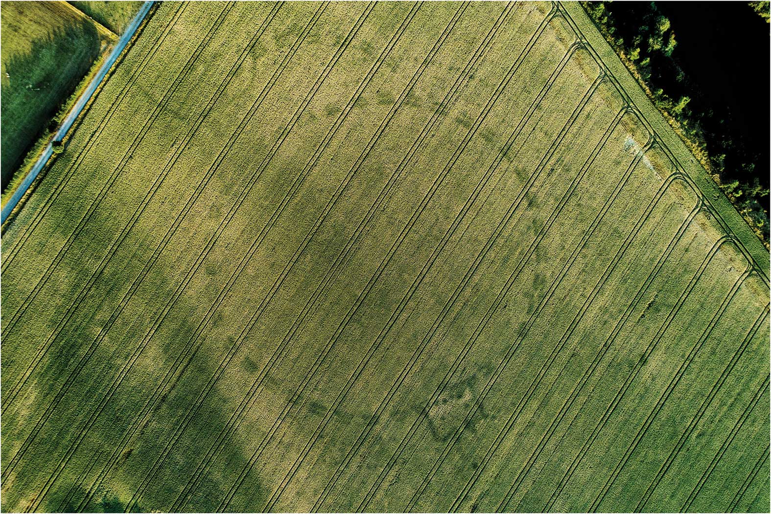
Over the past 50 years, archaeologists have developed ever more sophisticated means of seeing the unseen. A battery of non-invasive techniques now allows us to tease buried secrets out of the ground systematically. But, sometimes, as if thumbing its nose at our technological wizardry, the archaeology makes itself available to us more directly—and with less effort and in greater abundance. The high temperatures and low rainfall during the early summer of 2018 produced one of the richest harvests of parch and crop marks seen for many years in the UK and Ireland. The range of sites is astonishing: Neolithic henges, countless Bronze and Iron Age farms and enclosures, Roman towns and forts, medieval castles, the layouts of eighteenth-century country houses and formal gardens, Victorian military barracks, evidence for coal mining and abandoned railways, Second World War air-raid shelters and much more besides. Some of these marks revealed sites that were already known—documented on maps or glimpsed in previous dry summers. Many, however, are entirely new discoveries, and even some of the most intensively studied landscapes have produced surprises, including a large, new henge just a stone’s throw from the Neolithic passage tomb at Newgrange in Ireland (Figure 1).
Drone photograph of a henge monument that was revealed as a crop mark in a field close to Newgrange, in the Boyne Valley, County Meath, Ireland. The site was first identified by Anthony Murphy and Ken Williams in July 2018. Photograph: Ken Williams.
The hot summer days of 2018 are already a distant memory, but it will take archaeologists some time yet to log, map and identify all of these new sites, and to assess their individual and collective significance. Of these tasks, it is evaluation that is the most important, for the real value of these new discoveries lies not in their undoubted visual appeal, nor in ‘filling up’ the landscape with ever more traces of the past, but rather in transforming our archaeological understanding. Despite the serendipity around their discovery, parch and crop marks have great research potential, both in relation to the organisation and development of the wider landscape and for the interpretation of individual sites—even well-known ones. In 2013, for example, parch marks at Stonehenge revealed a series of previously undocumented features that informed renewed discussion about the monument’s complex form and construction sequence.Footnote 1
Another notable aspect of the bumper archaeological harvest of 2018 was the way in which it caught the public imagination, with high-profile media coverage and enormous online interest. In part, this was because impressive parch marks were plainly visible from ground level in public parks and gardens for all to see. But the game-changer, compared with previous hot summers, has been the availability of drones, which has put the means to prospect the landscape into the hands of a much wider group of amateurs and enthusiasts. Social media has also played an important role in the rapid dissemination of news about discoveries. The archaeological abundance of summer 2018 was a fortuitous and fertile coincidence of weather and technology.
The recording of crop and parch marks presents a challenge for archaeological authorities—the timing of their appearance and their location are hard to predict, and when they do appear, they are usually concentrated in a short window of time. By definition, they are less than amenable to logistical planning and systematic recording. Alongside the work of agencies such as Historic England and Cadw, therefore, the role of drone enthusiasts in 2018’s discoveries is significant. Over the past few years, citizen science projects have sought to harness the interest and numerical strength of the public to collect and process all sorts of archaeological data—from recording finds exposed by erosion around the UK’s coastline (CITiZAN: Coastal and Intertidal Zone Archaeological Network), to tagging, transcribing and geolocating digital records (MicroPasts crowdsourcing project). In most cases, these projects are set up and guided by professional archaeologists. In contrast, some of the imagery collected and circulated online over the past summer might be seen as a more spontaneous, bottom-up form of citizen science. One thing is for sure, O.G.S. Crawford, Antiquity’s founder and a key proponent of aerial archaeology, would have revelled both in the year’s archaeological discoveries and in the wide public appreciation of the value of seeing the past from above.
Fire and ice
![]() As well as parch and crop marks, the record heat and reduced rainfall of the summer presented other opportunities for archaeological discoveries. Lower-than-average precipitation caused the levels of rivers, lakes and reservoirs to fall, revealing submerged structures and objects. In Czechia, ‘hunger stones’—inscribed rocks recording drought-induced food shortages in the sixteenth and seventeenth centuries AD—were exposed in the River Elbe. Farther downstream in Germany, the same depleted river has produced an assortment of Second World War munitions. In some cases, low water levels have provided the opportunity to reacquaint ourselves with known features that are normally inaccessible, such as settlements drowned by reservoir construction. In other cases, the finds are new and unexpected. In Sweden, for example, a young girl discovered a 1500-year-old sword in a lake lowered by drought, and in Scotland, a carved Pictish symbol-stone was discovered by a fisherman in the River Don near Aberdeen. According to Gordon Noble—one of the authors of a paper on Pictish symbol-stones coincidentally featured in the current issue—the latter is a significant find and one that will, no doubt, add to the debate about whether these symbols represent a non-alphabetic writing system.
As well as parch and crop marks, the record heat and reduced rainfall of the summer presented other opportunities for archaeological discoveries. Lower-than-average precipitation caused the levels of rivers, lakes and reservoirs to fall, revealing submerged structures and objects. In Czechia, ‘hunger stones’—inscribed rocks recording drought-induced food shortages in the sixteenth and seventeenth centuries AD—were exposed in the River Elbe. Farther downstream in Germany, the same depleted river has produced an assortment of Second World War munitions. In some cases, low water levels have provided the opportunity to reacquaint ourselves with known features that are normally inaccessible, such as settlements drowned by reservoir construction. In other cases, the finds are new and unexpected. In Sweden, for example, a young girl discovered a 1500-year-old sword in a lake lowered by drought, and in Scotland, a carved Pictish symbol-stone was discovered by a fisherman in the River Don near Aberdeen. According to Gordon Noble—one of the authors of a paper on Pictish symbol-stones coincidentally featured in the current issue—the latter is a significant find and one that will, no doubt, add to the debate about whether these symbols represent a non-alphabetic writing system.
Other opportunities for archaeological discovery presented by this year’s high temperatures represent the intensification of longer-term trends. The melting of ice patches continues to reveal impressive finds of prehistoric clothing, tools and weapons,Footnote 2 as well as more recent archaeology; this year in the Swiss Alps, a melting glacier has yielded part of the wreck of a C-53 Dakota aircraft that crashed in 1946. A particular threat to Arctic landscapes is the increased frequency of tundra fires, which remove vegetation and soil surfaces, and which can expose archaeological materials and deposits.Footnote 3 More generally, wildfires have raged around the northern hemisphere this year: on the west coast of the USA, around the Mediterranean (most lethally in Greece) and beyond. A gorse fire on the usually verdant coast of County Wicklow, Ireland, revealed a sign—literally—from the past: the word ‘EIRE’, clearly spelt out in giant stone letters across the clifftop at Bray Head, a marker intended to ‘georeference’ pilots during the Second World War.
More typically, however, archaeologists need to work harder to identify and record the evidence revealed by such wildfires, although the results can be no less impressive. A fire on Fylingdales Moor in North Yorkshire in 2003, for example, burnt away peat to expose a rich prehistoric landscape, and the vast fires that burned across the Waterton Lakes National Park in Alberta in 2017 revealed numerous indigenous Blackfoot camp sites, as well as a more recent Depression-era work camp. Just as with parch marks and melting ice patches, however, time is of the essence: wind and rain can quickly erode materials exposed by fire. Combined with often remote locations and the enormous areas involved, the costs and logistics of identifying and recording such evidence are challenging.
Holocene divisions
![]() The summer of 2018 was not just hot, the temperatures were unprecedented. From the Arctic to the Mediterranean, and from Portugal across Asia to North America, records were broken. Norway, Japan and California, for example, all recorded new maximum monthly temperatures. Inevitably, the summer heat and the powerful early autumn storms that have followed (Hurricane Florence and Typhoon Mangkhut) have led to renewed discussion of climate change. Of course, no individual weather event can tell us much about climate change, but the long-term trend is both clear and disturbing. The scientific debate is no longer about whether the climate is changing, nor if humans are partly responsible, but rather about the radical solutions necessary to keep temperatures within 1.5ºC of pre-industrial levels. Even if emissions are reduced—a big if—climate scientists have warned of the risk of a ‘hothouse effect’, where feedback loops could still push the planet across a threshold leading to higher average temperatures than during any interglacial of the past 1.2 million years, and to the highest Holocene sea levels yet seen.Footnote
4
Such a scenario encourages us to look both forward and back in time, and to contemplate how human societies contribute and respond to climatic and environmental change. With its unique long-term perspective on the human past, archaeology is well placed to research the impact of climate change on people and, conversely, the impact of people on climate: how do complex societies respond to changing sea levels and rainfall patterns? When did our species begin to influence the climate? Do the effects of human activity on the climate merit the status of a new and distinct epoch—the Anthropocene?Footnote
5
The summer of 2018 was not just hot, the temperatures were unprecedented. From the Arctic to the Mediterranean, and from Portugal across Asia to North America, records were broken. Norway, Japan and California, for example, all recorded new maximum monthly temperatures. Inevitably, the summer heat and the powerful early autumn storms that have followed (Hurricane Florence and Typhoon Mangkhut) have led to renewed discussion of climate change. Of course, no individual weather event can tell us much about climate change, but the long-term trend is both clear and disturbing. The scientific debate is no longer about whether the climate is changing, nor if humans are partly responsible, but rather about the radical solutions necessary to keep temperatures within 1.5ºC of pre-industrial levels. Even if emissions are reduced—a big if—climate scientists have warned of the risk of a ‘hothouse effect’, where feedback loops could still push the planet across a threshold leading to higher average temperatures than during any interglacial of the past 1.2 million years, and to the highest Holocene sea levels yet seen.Footnote
4
Such a scenario encourages us to look both forward and back in time, and to contemplate how human societies contribute and respond to climatic and environmental change. With its unique long-term perspective on the human past, archaeology is well placed to research the impact of climate change on people and, conversely, the impact of people on climate: how do complex societies respond to changing sea levels and rainfall patterns? When did our species begin to influence the climate? Do the effects of human activity on the climate merit the status of a new and distinct epoch—the Anthropocene?Footnote
5
Of course, archaeologists are not the only group interested in such questions. In July, the International Commission on Stratigraphy (ICS), part of the International Union of Geological Sciences, announced formal ratification of a new official division of the Holocene, including designation of the past 4200 years as the Meghalayan Age. The announcement appears to have come as a surprise to many—and has provoked some controversy over the subsequent hot summer. The three newly defined ages are the result of several years’ work by an ICS sub-committee to formalise what was deemed to be a widely used but inconsistent division of the Holocene into early, middle and late (Figure 2).Footnote 6
The new ages of the Holocene epoch in the context of the Quaternary. Based on K.M. Cohen, D.A.T. Harper and P.L. Gibbard (2018). ICS International Chronostratigraphic Chart 2018/08. International Commission on Stratigraphy, IUGS. Available at: www.stratigraphy.org (accessed 1 October 2018).
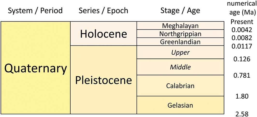
Key to the subdivision of any geological epoch is a marker or set of markers, such as fossil species or geomagnetic reversals, which are found worldwide and which can be radiometrically dated. Each division is referenced to an individual Global Stratotype Section and Point (GSSP), which marks the lower boundary of, and lends its name to, each age. Dividing the early and middle Holocene—now named the Greenlandian and Northgrippian respectively—at 8200 BP seems to have been relatively straightforward and uncontroversial. The boundary is marked by evidence for global cooling documented in ice cores and lake sediments, probably linked with the sudden outflow of fresh water into the North Atlantic. But dividing the middle and late Holocene—the Northgrippian and Meghalayan—has stirred greater debate. The new boundary is defined in relation to a range of geomorphological and stratigraphic proxies linked to aridification around 4200 BP (or the 4.2ka BP event); the GSSP is a shift in oxygen isotope (δ18O) values measured in a stalagmite from the Mawmluh Cave in the north-eastern Indian state of Meghalaya, whence the Meghalayan Age.
The announcement prompted further airing of technical arguments as to whether or not the evidence amounts to a sufficiently distinct, widespread and abrupt climatic change so as to mark a meaningful division. Others, particularly supporters of the Anthropocene (formal recognition of which is the subject of an entirely separate working group), have objected that ratification of the Meghalayan has muddied the waters by failing to acknowledge the role of humans in causing climate change.Footnote 7 But, beyond both the technical details and the broader societal implications, the most eye-catching aspect of the announcement for many archaeologists has been the link made with the fate of past human societies. An ICS press release was titled ‘Collapse of civilizations worldwide defines youngest unit of the geologic time scale’. Its slightly more cautiously worded text stated: “Agricultural-based societies that developed in several regions after the end of the last Ice Age were impacted severely by the 200-year climatic event that resulted in the collapse of civilizations and human migrations in Egypt, Greece, Syria, Palestine, Mesopotamia, the Indus Valley, and the Yangtze River Valley”.Footnote 8
There is certainly plentiful evidence for significant social and economic change across a variety of Old World societies during the late third millennium BC, but can this be packaged up as global civilisational collapse in direct response to a single phase of climate-induced drought? Not all agree. In a short Science ‘perspectives’ paper, archaeologist Guy Middleton argues that “[The] environmental and climatic determinism behind the megadrought collapse narrative fails to account for specific historical circumstances”, going on to point briefly to a range of archaeological research on issues of chronology and context from Egypt to China that complicate the story.Footnote 9 Others have expressed similar objections in various media coverage over the summer, reflecting an extensive archaeological literature that critically examines the connections between droughts and their impact on societies, individually and collectively, from Mesoamerica to Mesopotamia.
In practice, debate about the significance of the archaeological evidence has been polarised around two positions, broadly but not strictly divided along disciplinary lines. One group emphasises the cultural diversity of different human societies and their social and economic responses to climatic and environmental change; it measures time against human generations, and is cautious about connecting events widely dispersed in time and space. The other group takes a broader perspective, less concerned with cultural specificities and willing to accept changes distributed over several centuries and two continents, as a coherent set of evidence for a single event with a single cause. At least some of the disagreement between the two groups appears to relate to differing perceptions of temporal and spatial scale, and to divergent definitions of concepts such as resilience, agency and causality. What one group calls collapse, for example, the other sees as transformation.
Either way, it is worth recalling that the archaeological evidence is only one of several pillars supporting the Northgrippian–Meghalayan boundary, from pollen and diatoms in lake cores, to volcanic dust in glaciers, speleothem stable isotopes and peat formation—in short, a variety of proxies spread geographically across the Americas, Eurasia, Africa and Australia. Beyond adding human drama and consequence to the 4.2 ka BP event, it might therefore be asked how integral is the idea of civilisational collapse to the boundary’s definition, and what role should the archaeological evidence play? Hence, while the Meghalayan announcement marks the end of a long process of evaluation for the ICS, for many archaeologists, it will represent a new start. For it re-energises major questions about human-environment relations, and if, and how, the fates of distant societies were interconnected; it reaffirms the potential significance of our research for other disciplines and for society more generally; and it reiterates the need for renewed efforts to collaborate and to communicate our research as widely and clearly as possible.Footnote 10
In this issue
![]() This issue of Antiquity features articles showcasing the diversity of archaeology and archaeological research from around the world. We start with evidence for hominin tool-making at an Oldowan site in the Gona region of Ethiopia (de Lumley et al.). We then travel more than 2.5 million years through time, via the Sudanese Neolithic (Zerboni et al.), Chacolithic Spain (Guilaine), Iron Age Southeast Asia (Castillo et al.) and Viking Scandinavia (Hennius), to arrive at the pre-Colombian Middle Horizon in Peru (Bikoulis et al.; Wilkinson). Environmentally, we range from the arid desert of northern Arabia (Scerri et al.), via the vast expanse of the Mongolian steppe (Miller et al.), to the waterlogged shores of Lake Zurich (Bleicher & Harb); and in terms of scale, we move from microscopic pollen grains documenting maize processing (Heider & López) to the lidar mapping of the entire Mesoamerican polity of Izapa (Rosenswig & López-Torrijos). One particular theme that runs through a number of articles is the shift from hunting and gathering to food production. Or, more specifically, the diversity of this transition in different environments and the implications for our understanding of social complexity.
This issue of Antiquity features articles showcasing the diversity of archaeology and archaeological research from around the world. We start with evidence for hominin tool-making at an Oldowan site in the Gona region of Ethiopia (de Lumley et al.). We then travel more than 2.5 million years through time, via the Sudanese Neolithic (Zerboni et al.), Chacolithic Spain (Guilaine), Iron Age Southeast Asia (Castillo et al.) and Viking Scandinavia (Hennius), to arrive at the pre-Colombian Middle Horizon in Peru (Bikoulis et al.; Wilkinson). Environmentally, we range from the arid desert of northern Arabia (Scerri et al.), via the vast expanse of the Mongolian steppe (Miller et al.), to the waterlogged shores of Lake Zurich (Bleicher & Harb); and in terms of scale, we move from microscopic pollen grains documenting maize processing (Heider & López) to the lidar mapping of the entire Mesoamerican polity of Izapa (Rosenswig & López-Torrijos). One particular theme that runs through a number of articles is the shift from hunting and gathering to food production. Or, more specifically, the diversity of this transition in different environments and the implications for our understanding of social complexity.
The paper by Núñez and Perlès, for example, examines the site of Tulán-52 in the Atacama Desert, which they argue to be not a residential settlement as previously thought, but a ceremonial centre associated with feasting, craft production and monumentality. Importantly, this shifts the emergence of such ritual centres two millennia back in time; Tulán-52 was constructed not by the food-producing societies of the Formative period, but by the last hunter-gatherer communities of the Late Archaic. As at Göbekli Tepe,Footnote 11 this seems to suggest that the shift to food production may have been a response to increasing social complexity, not the other way around. Meanwhile, Denham et al. examine the evidence for an independent centre of plant domestication in southern China. This tropical environment provided humans with very different possibilities for food production compared to central and northern China or the Near East. In particular, plants such as taro and yam, which can propagate asexually, challenge the dominant archaeological models of domestication that are based on crops such as cereals; they also confound our standard archaeobotanical methods. Denham and colleagues therefore argue for the need for more attention to the recovery and study of plant tissues (parenchyma) from roots and tubers in order to advance our understanding of the scale, organisation and timing of plant ‘management’ across a huge arc extending from southern China, through Southeast Asia, to northern Australia.
Finally, a reminder to take a look at our Project Gallery articles. Linked to each issue of Antiquity is a selection of short, original, online-only contributions. Project Gallery papers from the current issue include two further responses to our April Debate piece on archaeology’s response to ‘reactionary populism’,Footnote 12 as well as research on burials at Bronze Age Bethlehem and the Meroitic-era cemetery at Jebel Moya in Sudan. There are also articles reporting varied research from the Altai Mountains, Belarus, Germany, Sardinia and Palmyra. All these Project Gallery articles, and our complete archive of over 500 others, are available free to access via our website (https://www.antiquity.ac.uk/open/projgall). Head online to start exploring!
1 October 2018


