

Introduction
Extensive and continuous radar stratigraphy in glaciers, ice sheets and ice shelves has been recognized to result primarily from density variations within the firn regime, and from conductivity variations within the englacial regime. In polar ice sheets density contrasts profiled by radar over multi-km distances appear to be generated by hoar and ice-crust formation (Reference Arcone, Spikes, Hamilton and MayewskiArcone and others, 2004, Reference Arcone, Spikes and Hamilton2005) and are expressed through their relative dielectric permittivity, ε. In valley glaciers these contrasts may also have been caused by annual accumulation and melt cycles (Reference GogineniKohler and others, 1997; Reference Arcone, Prentice and DelaneyArcone and others, 2002). The conductivity (~) contrasts that generate extensive englacial horizons in polar ice sheets mainly result from sulfate ion distributions (Reference Fahnestock, Abdalati, Luo and GogineniHempel and others, 2000). Valley glaciers, temperate or not, however, have appeared to lack these englacial horizons. Here we discuss radar profiles of Clark and Commonwealth Glaciers, within the Dry Valleys region of Antarctica (Fig. 1), and possible reasons for their lack of englacial horizons.
Location of our sites in the Dry Valleys area.

Airborne or surface radars used on ice sheets take advantage of long distances by using high rates of signal trace stacking and synthetic aperture processing to enhance signal-to-noise (S/N) ratios and develop extensive profiles of englacial stratigraphy. Profiles acquired in Greenland with airborne 150MHz chirped radar to 3 km depth (Reference Denton and HallGogineni and others, 2001), and with a 400 MHz frequency-modulated continuous-wave (FM-CW) system to >280m depth (Reference Fukazawa, Sugiyama, Mae, Narita and HondohKanagaratnam and others, 2001), also suggest that σ contrasts within multi-km-deep englacial horizons must be evenly distributed to permit weak conductivity contrasts to be detected above noise levels at such high frequencies. In contrast, deep profiles on small valley glaciers must be obtained by hand towing or snowmobile over distances on the order of a few km. Despite the preclusion of significant trace stacking over long distances, these profiles have shown strong bottom horizons, internal diffractions related to conduits, and thermal stratification (e.g. Reference Bertler, Mayewski, Barrett, Sneed, Handley and KreutzBjörnsson and others, 1996; Reference Arcone, Lawson, Moran and DelaneyArcone and others, 2000; Reference Kreutz and MayewskiMoorman and Michel, 2000). Any system inadequacies in sensitivity have been compensated by using pulses centered at 5 MHz (Reference Moorman and MichelWelch and others, 1998) and 12MHz (Reference Arcone, Lawson, Moran and DelaneyArcone and others, 2000), which are 26 to 18 dB more sensitive, respectively, to conductivity changes than are pulses centered at 100 MHz, and by profiling in the ablation zone where old englacial ice would be near the surface. Yet in all cases but one, englacial stratification to depths greater than about 100m did not appear; the one case reached about 140m at 35 MHz at Victoria Glacier (M.I. Watson and others, http://www.gpr2008.com), located near our study sites. In some cases, englacial radar horizons would have been obliterated by scattering from conduits (Reference Arcone, Lawson, Moran and DelaneyArcone and others, 2000), a situation not likely to occur in Antarctica.
We obtained the data discussed here by hand-towing commercial ground-penetrating radar (GPR) (Fig. 2) across axial and cross-sectional transects. We chose pulses centered at 100MHz because of our success in penetrating temperate ice to nearly 200m (Reference Arcone, Lawson, Moran and DelaneyArcone and others, 2000). Our purpose in using GPR was to find suitable sites for ice cores to study the climate history of the region. We sought sites with relatively flat stratigraphy that we hoped would be visible to the bottom. However, despite continuous, strong bottom horizons to 280 m depth, and stratigraphy within the top 50–80 m, there are no englacial horizons for the remaining 200–230 m. The 80 m depth was well below the firn–ice density transition, so we hypothesized that strata by this depth were responses to conductivity contrasts.
Profiling on Clark Glacier. Inset shows the 100MHz pulse waveform recorded at 1170 m along the axial profile.
The purpose of this paper is to determine likely causes for this lack of englacial strata. Our objectives were to determine likely reflection coefficients given possible ionic contrasts, and possible causes for their degradation. We calculated the S/N available from the strongest bottom signal, and compared it with likely reflection coefficients for the measured ice-core ionic concentrations. We found the depth of the firn–ice transition from core-density profiles to estimate the limiting depth of density reflections, and measured radar-horizon fold dips to investigate aliasing. We used sulfate and other ionic profiles from a 12 m ice core and from snow pits, wind direction profiles, and changes in S/N with depth to speculate on the cause of an uneven ion distribution. Ice-core chemistry analysis is ongoing as of this writing. We conclude that deep horizons probably did exist, but that system insensitivity combined with low reflection coefficients resulting from ion concentrations with high background levels and rapid variability are most likely to have precluded englacial radar horizons.
Site Locations
Clark and Commonwealth Glaciers are alpine valley glaciers located in the Dry Valleys region of Antarctica (Fig. 1), where the major valleys are presently ice-free. Commonwealth Glacier flows into Taylor Valley, and Clark Glacier flows into a small embayment at the end of Wright Valley. They are frozen to the bottom because they move about 1 ma–1. The mean annual temperature is about –18˚C. Their mass is balanced between accumulation and ablation. We measured accumulations of 0.025 and 0.034mw.e. a–1 on Clark and Commonwealth Glaciers, respectively, with each an average from five pits and with a range of 0.01–0.07ma–1 (Reference Shabtaie and BentleyWilliamson and others, 2007). We obtained our profiles in the upper basins where the near-maximum elevations of the glaciers are near 750 m and maximum ice depths are about 270–280 m, as revealed within our profiles. The profiles we discuss are 600 (cross-glacier) and 1900m long (axial direction) on Clark Glacier and 1300m long on Commonwealth Glacier (cross-glacier). We obtained them in late November 2003, and we cored and sampled (Table 1) during November 2004 and November 2005. The two cores and the all-weather station (AWS) we placed on Clark Glacier are very close.
Core site and the all-weather station (AWS) locations. The Clark cores were placed <1m apart to verify ion stratigraphy

We sought our ice cores to help resolve the controversial climate history of the Dry Valleys. Ice-core isotopes from Taylor Dome, within 100 km of our sites, indicate sub-zero temperatures and deglacial warming trends similar to that at Greenland summit and interior West Antarctica since the end of the Wisconsin glaciation 20 000 ka BP, and present-day accumulation rates extending to at least 10 000 BP (Reference Moore, Mulvaney and ParenSteig and others, 2000). However, the existance of a large lake in Taylor Valley (Reference Moore, Wolff, Clausen and HammerStuiver and others, 1981) within the 8340–23 800 years BP time frame (Hall and Denton, 2000) suggests warmer conditions, minimal sea-ice cover and more precipitation to grow and advance alpine glaciers, as evidenced by the moraines in front of Clark Glacier (Fig. 3) and other alpine glaciers. The close proximity of the glacier snouts to the moraines suggests that snowfall since the end of the last ice age has been similar to the present.
Location and direction of profiles on Clark Glacier. The dot locates the site of our closely spaced cores and the center of an 800m square grid of five snow pits, one at each corner and one at the center. Arrow lengths are not exactly to scale. Flow is in direction of axial arrow.
Given the present accumulation rate of 0.025ma–1, a depth of 100 m from the surface would represent 5000 years (Nye model), beneath which we recorded no horizons. However, without a core we have no historical record of accumulation rates from which to calibrate age versus depth. Consequently, we expected the relatively large upper basins of these glaciers to exhibit flat and surface-conformable strata in which to obtain reliable depositional, isotope and ion records.
Equipment and Methods
We used a Geophysical Survey Systems Inc. (GSSI) SIR10b control unit and model 3107 (100 MHz) transceiver single (‘monostatic’) antenna (Fig. 2). The pulse waveform (Fig. 2 inset) has ~35% 3 dB bandwidth. We polarized the antenna orthogonally to the transect directions. The antenna directivity is characterized by transmit–receive 3 dB widths of 92˚ along the transect direction and 42˚ along the antenna axis (Reference ArconeArcone, 1995).We recorded at 4000 ns time range and 4096 16-bit samples per trace. We used range gain, and removed constant background clutter with a horizontal filter. We located distance markers with a differential global positioning system (GPS).We extracted pulse wavelet amplitude envelopes with a Hilbert magnitude transform to clarify the stratigraphy within the compressed scale of presentation, and migrated one profile to better estimate S/N.
The preclusion of snowmobiles by environmental regulations limited us to hand towing. We used a trace acquisition rate of 13 s–1, a simultaneous running 16-fold stack and a profiling speed of ~1ms–1 that resulted in ~1 trace recorded every meter. Therefore, each of the 16 individual traces that made a stack was recorded every 0.06 m. Our final interpolated trace spacing was 1 m after minor horizontal justification in processing with no further stacking. Consequently, Hilbert transformation before stacking as a means to improve horizon detection (Reference Hempel, Thyssen, N., Clausen and MillerMoore and Grinsted, 2006) was not possible.
We determined density in the field by weighing and measuring the 1 m core sections. Our accuracy was often lessened by loss of mass due to breakage in the core barrel. We mainly used our best-quality density profile (Clark core 1) to determine average relative permittivity values for depth calibration of complete soundings. The firn reached a density of 820 kgm–3 (" = 2.9) by only 36m depth and a solid-ice value (900) for the remaining 240 m. We calculated ε = 3.1 for our deep profiles, with a depth scale error <2.2% for a total thickness of 240 m or more and for firn reaching 917 kgm–3 by 60 m. Additionally, we measured wind speed and direction on Clark Glacier from November 2004 to December 2005 with our AWS. We determined accumulation rates from chemistry profiles of the snow-pit samples. We used ion chromatography to measure ion concentrations at 0.02 m intervals.
Radar Profiles
The two profile transects on Clark Glacier are located in Figure 3. The complete axial profile (Fig. 4 bottom) mainly shows the continuous bottom horizon. The upper section (Fig. 4 top) contains the stratigraphic horizons, which are undistorted, surface-conformable and visible to ~60m depth. The cross-section profile (Fig. 5), recorded at 300 m distance along the axial transect, shows that the axial horizons dip in cross-section. Continuous stratigraphy is visible to ~77mdepth; a small segment of an apparent horizon at 98 m depth is barely visible. The dipping horizons have a maximum slope of 3.5˚ Cross-sections recorded further down-glacier at 400 and 500m revealed virtually identical stratigraphy. The maximum surface slope is 0.8˚, with elevation rising from south-southwest to north-northeast.
Upper section of (top), and complete (bottom) axial profile recorded on upper Clark Glacier. The profiles have been Hilbert-magnitude transformed to make the strata more visible. We used an average ε = 2.7 for the upper section and ε = 3.1 for the complete profile to calibrate depth from the timescales. We derived these relative permittivity values from the computed total time delay through the ice cores at their measured densities. The profile of Figure 5 crosses at the black arrow.
Upper section of the Clark cross-glacier transect recorded at 300m distance downslope. Strata are barely visible near 100m depth. Clark cores 1 and 2 are at arrow 1, and the axial profile crosses at arrow 2. The white arrow indicates a faint apex of a synclinal fold in a discontinuous horizon.
A faint, but likely sub-bottom, horizon (Fig. 6a) provides evidence of good bottom transmissivity, and therefore a low permittivity for the bottom material. The value ε = 5.3 that we have consistently calculated from hyperbolic diffractions for the frozen sediments in the Dry Valleys (Reference Arcone, Prentice and DelaneyArcone and others, 2002) provides a bottom reflection coefficient ┌ = –18 dB for normal incidence. The strongest bottom reflection (Fig. 6b) occurred at 262 mdepth within the axial profile. The centering of its trace spectrum (Fig. 6c) near the 100 MHz design frequency indicates no loss of high-frequency energy due to scattering after 524 m of round-trip propagation.
Detail of Clark Glacier axial profile showing (a) evidence of sub-bottom penetration; (b) a section of the trace recorded at 1000 m; and (c) its spectrum.
We locate the transect of our cross-glacier profile on Commonwealth Glacier in Figure 7. The upper section of the full transverse profile (Fig. 8) contains the stratigraphic horizons. A few minor folds occur to about 60 m depth up to the 600 m distance, followed by larger anticlinal folds centered at 750 and 1000m distances. Given no surface topographic anomalies of any significance, it seems unlikely that this folding resulted from continuing differential snow deposition or any subsurface topography. Underlying these larger folds is a synclinal fold centered at 900m distance and dipping to ~82m depth. This complex folding may have been caused by compressive flow from tributaries west of the upper basin. From 600 to 650 m, the slope of the deepest, and steepest, anticlinal fold is ~11˚.
Location of our cross-glacier profile transect on Commonwealth Glacier. The dot locates our core sites and the center of an 800m square grid of five snow pits, one at each corner and one at the center.
Upper section of (a), and total (b) profile recorded on upper Commonwealth Glacier. The profile has been processed with a Hilbert magnitude transform. The arrow locates our core site. We used relative permittivity values of ε = 2.7 and 3.1 for the upper and lower profiles, respectively, as described in the Figure 4 caption. The deepest visible stratum is at 82 m. The dashed rectangle contains the trace shown in Figure 9.
We exploit the strongest signal (Fig. 9) recorded in any of our profiles to estimate the S/N available from our system. The trace shown is from a migration we performed to align the traces properly with surface location and collapse any possible interfering diffractions. We computed root-mean-square noise levels at several depths from 200 ns windows centered at various depths along the trace shown. We computed signal strength at these depths by compensating the strength of the shown bottom signal for change in depth. The resulting ratios were then corrected for the range gain applied during recording. The table in the figure shows that the S/N would steadily increase with decreasing depth to a value of 37.5 dB at 77 m, which is about where radar horizons are no longer visible. Adding the energy lost from the bottom reflection coefficient of –18 dB provides an estimated 56 dB of available signal strength at this depth. These S/N values are a major reason why any chemically related strata, if they existed, were not detected.
Migrated bottom reflection at 267m depth and 896m along the Commonwealth Glacier profile in Figure 8. The dashed box contains a segment centered at 242 m that we used to compute the S/N ratio after adjusting signal amplitude (S) to this depth and compensating it for the applied range gain. The table shows how S/N for this signal would decrease with depth.
Possible Causes of Absent Englacial Strata
Density contrasts
Our density profiles (Fig. 10) show impermeable ice (density = 820 kgm–3) was reached by only 36 m in Clark Glacier. Ice of 900 kgm–3 was reached by 55 m for Clark core 1 and by 67m for core 2. Ice of 900 kgm–3 density was reached at 59m on Commonwealth Glacier. The large perturbations resulted from loss of mass caused by observed core breakage; they are largely absent in the Clark core 1 profile. A 1cm hoar layer of 11% less density (816 kgm–3) than ice would give a reflection coefficient ┌ = –55 dB, which nearly equals the S/N ratio we calculated above to be available at 77 m depth. A 2 cm layer would require a density difference of 6% (862 kgm–3) to give the same ~. These large contrasts are unlikely to have existed by 60 m depth, so horizons below about 60 m are probably caused by σ contrasts.
Density profiles measured on Clark and Commonwealth Glaciers. The transition to impermeable ice occurs at about 36m depth in both Clark profiles. Large anomalies, and low values below 60 m depth for Commonwealth most likely resulted from loss of mass caused by breakage, which we do not account for.
Stratigraphic slope
Given a slope of θ for a reflecting stratum, the round-trip difference, △z, in propagation distance between two consecutive traces xm apart is △z = 2x sin ±, where the sine, rather than the tangent, accounts for the antenna offset from the position above the points of reflection. A △z of one half-wavelength (±/2) produces a round-trip phase shift of 180˚ and destructive interference between two consecutive traces reflected from a single horizon. Each recorded trace was a stack of 16 traces spanning approximately 1 m. The maximum slope of the steepest visible anticlinal fold in Commonwealth Glacier is ~11˚, for which △z between traces spanning 1 m (as in our profiles) is only 0.38 m. This is <±/2 = 0.82 m for an in situ ice wavelength λ = 1.68m at 100 MHz. Therefore, deeper horizons would need to have been steeper to be severely degraded.
The maximum slope for the dipping strata within the transverse profile across Clark Glacier is only θ = 3.5˚. It appears that this small surface slope resulted from compressive deformation, rather than from differential snow deposition caused by topographic slope (Reference Arcone, Spikes and HamiltonArcone and others, 2005), because the predominant summer wind was from the southeast and the winter wind from the northwest (Fig. 11). The deformation was possibly caused by axial flow against the tributary visible down-glacier from the profiles and on the north side. This slope gives a △z = 0.12 m, which is insignificant compared with ±/2 = 0.82 m. The strata profiled along the axial Clark transect was at constant dip transverse to the transect direction because this same stratigraphy was also recorded along the other two cross-sections. Therefore, even if the slope increased by four-fold at four times the depth, it should have been easily detectable along the axial profile given sufficient interface reflectivity.
Hourly wind direction data from Clark Glacier. A shift in wind direction occurred in late summer (February 2005).
Ionic composition and vertical distribution
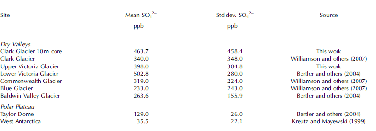
Our chemistry profiles (Fig. 12) from the upper 12.5 m of Clark core 1 show unusually strong and varied concentrations of major ions, as do those from Commonwealth Glacier and other nearby glaciers (Table 2; Reference Shabtaie and BentleyWilliamson and others, 2007). The distributions are synchronous in depth (or time, for this single core). The ionic nature results mainly from the material being in solution within the melted ice samples, but sulfate and nitrate ions in solution cause the acidity that correlates with σ (Reference Kohler, Moore, Kennett, Engeset and ElvehøyMoore and others, 1992). In turn, σ correlates with ice-sheet englacial radar horizons and volcanically derived sulfates (Reference Fahnestock, Abdalati, Luo and GogineniHempel and others, 2000), the concentrations of which might reach a maximum value on the order of 250 ppb. Sulfate and nitrate ions have been identified in triple junctions (Reference Cullen and BakerFukazawa and others, 1998), and are likely within water films there and along grain boundaries (Reference SteigWolff and others, 1988; Reference BjörnssonCullen and Baker, 2001). Reference BjörnssonCullen and Baker (2001) also identified sodium and chlorine in these areas, where they are likely in ionic form, and also found sulfur in solid inclusions.
Sulfate statistics for various Dry Valleys and Antarctic plateau sites. Std dev. is one standard deviation. All values represent at least 3 years of data from either ice cores or snow pits, except for the West Antarctica values, which are from a single snow pit near Byrd Surface Camp
Major ions in the 12.5 m core from Clark Glacier. Sodium and calcium data were not obtained between 9 and 10 m.
As compared with mean concentrations of 35 ppb across the West Antarctic plateau, mean values for various Dry Valleys glaciers are several hundred ppb (Table 2), with peak values of several thousand ppb, at least in the top 8 m. Our greater sulfate-ion concentrations are caused by proximity to the ocean, as identified by the type of sulfate ion. Consequently, volcanically derived acids must be overwhelmed by marine deposition, so equivalents of the numerous ice-sheet englacial radar horizons up to 20 000 years old (Fahenstock and others, 2001) should not be present.
The synchronicity of all elements in Figure 12 and the 0.5 mand more separation of peaks between 2 and 4 mdepth suggests detectable σ contrasts. However, near 12 m depth the peaks weaken and are closer together, implying decreasing σ contrasts with depth. The synchronicity with chlorine, especially at 8 m depth, shows that all were derived from the ocean, with peaks occurring during storms. Consequently, it seems unlikely that any significant neutralization of the acids occurred from dust, as is believed to have occurred within Wisconsin-age ice (Reference SteigWolff and others, 1988).
System sensitivity
We address system sensitivity by comparing our S/N values (Fig. 9) with estimates of ┌ based on possible conductivity contrasts, ±~. In this case, where ω is the radian frequency, and ε 0 is the permittivity of free space. Background Antarctic polar plateau firn conductivity values are ~1±10–6Sm–1 (Reference Moore and GrinstedShabtaie and Bentley, 1995), which correspond with low values such as 35 ppb (Table 2). The mean sulfate-ion value for the profile in Figure 12 is 464 ppb, and the highest value we have found so far is 4000 ppb measured in pit 2 (Fig. 13). Assuming ion mobility does not change significantly with concentration, 463 ppb would correspond with ~~1.3±10–5Sm–1, and 4000 ppb would give a ~~11.4±10–5Sm–1. (These values are near those found by Reference Kanagaratnam, Gogineni, Gundestrup and LarsenMoore and others (1989) at another coastal site with similar mean temperature.) The resulting ±~~1±10–4Sm–1 so that Γ = –57 dB at 100MHz for this simple interface model. This decreases to –56 dB if we consider the background to be only 100 ppb, as can be seen by the minima near each peak, such as those within 0.2 m of the peaks at 2.4, 2.9, 4.0, 5.8 and 7.2 m. Using a plane wave model (Reference Arcone, Spikes, Hamilton and MayewskiArcone and others, 2004), a more realistic thin layer ranging from 0.1 to 1.0m thickness decreases maximum Γ values for a simulation of our pulse waveform to between –61 and –69 dB. These values are insufficient for detection at 56 dB S/N we estimated above to have been available at 77 m depth, but we did not investigate the effect of a series of closely spaced layers.
Sulfate concentration profiles for the five snow pits logged in 2004 on Clark Glacier. The pits were centered at the dot in Figure 3.
The occurrence of our deepest horizon at 100 m on Clark Glacier appears consistent with this calculation and with our estimate of loss of sensitivity to density contrasts by at least 77 m depth. Lowering the radar signal frequency increases Γ and the ability to detect σ contrasts; 35 MHz will provide a 9 dB decrease in ~. Strata recorded on nearby Victoria Glacier (maximum ice depth comparable to Clark and Commonwealth Glaciers) with a similar system at 35 MHz (M.I. Watson and others, http://www.gpr2008.com) reached 140 m. A pulse center frequency of 10 MHz would strengthen the reflection coefficient by 20 dB and presumably lower noise, but the in situ wavelength of 17 m would compromise vertical resolution of closely spaced layers.
Ion lateral distribution
Possible non-uniform ion distribution in a lateral (areal) sense is evidenced by the 0.01–0.07ma–1w.e. range of first-year snow accumulation, cited above. This does not contradict the uniform horizons within the upper 50m in Figures 4 and 8 because they are likely responses to hoar layers, which are superimposed upon the accumulation distribution (Reference Arcone, Spikes, Hamilton and MayewskiArcone and others, 2004, Reference Arcone, Spikes and Hamilton2005). Therefore, these isochronal horizons do not indicate uniform snowmass deposition because it cannot be assumed that the firn between them all fell during the same time period. These variable accumulation rates are qualitatively consistent with sulfate records from our five 1 m deep snow pits (Fig. 13) on Clark Glacier. These profiles show maximum concentrations at 48–74cm depth, which is likely due to non-uniform wind conditions throughout the year (Fig. 11). This 26 cm difference in depth corresponds with a round-trip phase difference of ~±/4 in firn (ε = 2 at 100 MHz) and ~±/3 in ice (ε = 3.18), which will lessen the reflectivity of a high-concentration layer. Compression by burial will decrease these depth differences: a separation of 30 cm between sulfate peaks in firn at 12 m depth (density = 0.57 kgm–3) will decrease to 19cm in ice. However, it may also reduce the concentration intensity (see Fig. 12).
Conclusions
The appearance of faint reflection horizons at 60–100m depth on Clark Glacier and horizons at 140m by others using a lower frequency imply that detectable horizons of conducting ions exist. This suggests that the asynchronous variability in ion concentrations with depth between snow-pit profiles decreased with depth, although it still may have caused some of the noise in our profiles. Therefore, our inability to detect deeper englacial horizons was likely caused by decreased layer reflectivity resulting from an absence of sufficient vertical ionic contrasts, as evidenced by the decreasing intensity, and separation between sulfate peaks in Figure 12. Any additional convincing evidence of decreasing contrasts of ionic concentration with depth awaits continued processing of our cores. A core ECM (electrical conductivity measurements) profile would verify any conductive layer structure (Reference Kohler, Moore, Kennett, Engeset and ElvehøyMoore and others, 1992).
The S/N needed to detect the ion contrasts of our 12.5 m profile could be achieved at depth either by lowering pulse frequency or by increased rates of stacking. A lower frequency will strengthen ~, as noted above; a pulse center frequency of 10MHz may be needed to detect strata near the bottom. Although its 1.5-cycle, 25 m pulse length in ice would decrease vertical resolution, such a lengthened pulse might still resolve bands of closely spaced layers and reveal the depth of conformable strata. Stacking would increase S/N by 10 logN where N is the number of stacks. An additional 10-fold stack (giving a total of 160-fold for our profiles) would have provided an additional 10 dB, but stacking may not necessarily be effective if the key ions are well distributed throughout layers on the order of ±/4 thick, and deep folding exists. In any case, longer profiles than ours would allow more stacking.
Acknowledgements
US National Science Foundation award OPP-0228052 supported this work. We thank our program manager J. Palais and our fellow project members E. Osterberg, B. Williamson and M. Waskiewicz for their support, and H. Anschütz and an anonymous reviewer for helpful comments.


