




1. Introduction
One distinguishing characteristic of language and the way humans use it to describe the environment is a seeming need to segment continuous surfaces into objects (Mark, Smith & Tversky, Reference Mark, Smith and Tversky1999), and in particular, to give settings in the landscape proper names, or placenames (Tuan, Reference Tuan1975). Despite the fundamentally different environments in which humans live, placenames seem to be a near-ubiquitous way (Burenhult & Levinson, Reference Burenhult and Levinson2008:138–39) of categorizing and communicating about shared spaces. As such, they offer an exciting opportunity for interdisciplinary studies exploring landscape in the form of “perceived environment”Footnote 1 (Collot, Reference Collot1986). Since placenames are not random but rather form systems, they can reveal more than linguistic history (Taller de Tradición Oral & Beaucage, Reference de Tradición Oral and Beaucage1996), providing windows into anthropological questions related to connections between resources and the environment (Thornton, Reference Thornton, Mark, Turk, Burenhult and Stea2011), cognitive studies of the parts of the environment considered salient enough to name (Smith & Mark, Reference Smith and Mark2001) and ontological explorations of the basis of such systems of categorization and communication (Hunn, Reference Hunn1994). The potential of exploring the relationship between the environment, or more narrowly, landscapes, and language has been recognized by a series of interdisciplinary studies focusing on ethnographic approaches to gathering linguistic data and relating them to landscape (Boillat et al., Reference Boillat, Serrano, Rist and Berkes2013; Burenhult, Reference Burenhult2008; Mark et al., Reference Mark, Turk, Burenhult and Stea2011; Seidl, Reference Seidl2008).
Such approaches go some way to answering longstanding calls for researchers to discard monodisciplinary attempts at understanding relationships between humans and their environment (Boas, Reference Boas1934:14; Descola & Ingold, Reference Descola and Ingold2014). Indeed, from an anthropological perspective “place names tell us something not only about the structure and content of the physical environment itself but also how people perceive, conceptualize, classify, and utilize their environment” (Thornton, Reference Thornton1997:209). They give information about what is significant for people and how they organize space (Afable & Beller, Reference Afable, Beeler and Goddard1996:185). From a geographical perspective, Tuan describes language as having an ability to transform nature into a human place by construing conceptual categories from materially insignificant and unconnected entities and thus making the invisible and nonexistent visible and real (Tuan, Reference Tuan1991).
If placenames encode so many ways of understanding the link between the environment, culture, and cognition, then interdisciplinary approaches to analyzing these names might hold the key to better understanding such relations holistically. However, despite their ubiquitousness, we also need to recognize the diversity of placenames. This diversity is multifaceted and applies both within and across cultures. Thus, placenames are described as having multiple and divergent functional underpinnings and usage, from the disambiguating and jurisdictional applications of ownership and administration often associated with western societies (Rostaing, Reference Rostaing1948), to sociocultural functions as anchoring points for communication and transmission of knowledge about people, events, resources, and history (Cogos, Roué, & Roturier, Reference Cogos, Roué and Roturier2017; Garde, Reference Garde2014; Thornton, Reference Thornton, Mark, Turk, Burenhult and Stea2011). Linguistically, too, placenames and placename systems vary on several levels (Burenhult & Levinson, Reference Burenhult and Levinson2008). For example, the structural complexity of names varies so that they can be one-word forms, or they can be full phrases or sentences (as among the Western Apache: Basso, Reference Basso1988). From a semantic point of view, names can be transparent—that is, their meaning can be fully accessible to present day language users and analysts—or shrouded in history and therefore opaque and understandable only through etymological analysis by experts. Furthermore, their transparent or etymologically derived meanings can be drawn from a wide variety of lexical source domains, such as landforms, body parts, animals, plants, objects, personal names, properties, events, and so on. Some are highly descriptive of the setting they name while others show no such relationship. Finally, independently of their meaning, placenames vary as to which types of entities they single out for reference. For example, languages may or may not systematically name sites of human settlement (O’Meara et al., Reference O’Meara, Burenhult, Rothstein and Sercombe2020). Importantly, although placenames might be assumed to map onto the same ontology as generic landscape and settlement terms (so that they refer to individual examples of entities labeled with terms such as “river,” “valley,” “village”), languages differ from each other in terms of the extent to which this is the case (Burenhult & Levinson, Reference Burenhult and Levinson2008).
This diversity of ways in which form, meaning, reference, and usage can be associated with placenames points to the importance of exploring them not in isolation but rather as part of a system revealing the variety of strategies with which humans relate to the environment over time and space. Understanding this diversity is challenging for a number of reasons. From an anthropological perspective, ethnography is best suited to gathering data about indigenous systems of naming, but it is important to interpret such data without imposing western ontologies of organization (Descola, Reference Descola2019). Moreover, interdisciplinary approaches exploring place names often involve the use of digital tools such as Geographic Information Systems (GIS). However, mapping indigenous data using GIS or digital database technology has been criticized, often for imposing inappropriate models on indigenous knowledge (Agarwal, Reference Agarwal2005; Agrawal, Reference Agrawal2002; Rundstrom, Reference Rundstrom1995; Sieber, Reference Sieber2000). The application of these technologies was questioned by Rundstrom in a postmodernist context (Rundstrom, Reference Rundstrom1991), who pursued a debate opened by Harley (Reference Harley1989), warning of the difficulties in mapping cultures with no written traditions. The creation of text or a map implies the fixation of information in time, and this goal can be at odds with ways of communicating in oral traditions. Rundstrom used the concept developed by Connerton in 1989, distinguishing between “incorporation” and “inscribing” when he considered cultural practices and the knowledge associated to them. He highlighted that changing this method of preserving knowledge necessarily has consequences to which we must pay attention. Rundstrom thus called for a social or cultural mapping that takes into account these commemorative actions and that minimizes the aspect of fixing information over time. Rundstrom was strongly critical of the mapping of indigenous knowledge, pointing out the risks of the process destroying indigenous culture through the standardization and the uniformization of data, changing knowledge into an object, “tangible and accessible” (Rundstrom, Reference Rundstrom1995:52). Less radically, Lake (Reference Lake1993) stated:
ultimately at issue is whether the integrative capacity of GIS technology proves robust enough to encompass not simply more data but fundamentally different categories of data that extend considerably beyond the ethical, political, and epistemological limitations of positivism (Lake, Reference Lake1993:411).
Nevertheless, progressively, use of GIS technology has been slowly welcomed with Harvey calling it a “technological artifact … which reinforce social agreements about human geography” (Harvey & Chrisman, Reference Harvey and Chrisman1998:1693) and Sieber, who recognized the plasticity of this technology while calling for more efforts regarding the analyses of social information (Sieber, Reference Sieber2000). Moreover, in 2011, Sieber and Wellen (Reference Sieber, Wellen, Mark, Turk, Burenhult and Stea2011) highlight that:
For us, a GIS offers three approaches to integrating landscape and language. It is a mapping tool, and it is a spatial analytic modeling method. Lastly, it is a language unto itself producing a digital and abstracted landscape of the imagination that we can interrogate (Sieber & Wellen, Reference Sieber, Wellen, Mark, Turk, Burenhult and Stea2011:384).
Indeed, they argued that the use of this technology can have numerous advantages, and specifically, GIS as database has the potential to merge information of very diverse types (Sieber & Wellen, Reference Sieber, Wellen, Mark, Turk, Burenhult and Stea2011:383). This is what was also demonstrated by Robbins (Reference Robbins2003) using GIS as an approach able to create “a level playing field for comparing knowledge consensus and division” (Robbins, Reference Robbins2003:239) in order to interrogate the knowledge itself.
To date, however, there have been few attempts to employ GIS to explore and understand indigenous categories as expressed in language (for a recent example see Burenhult & Purves, Reference Burenhult and Purves2020).
The diversity and frequent obscurity of such linguistic representations of landscape, introduced above, add further levels of complexity to the conglomerate of intangible sociocultural practices and knowledge deemed so inaccessible to mapping by Rundstrom, Lake, and others. Yet the universal referential function of these diverse representations undoubtedly makes them spatially pertinent and therefore potentially interesting to map and explore geographically for any speech community. The language sciences, on their part, are ill-equipped to alone investigate the relationship between landscape categories in language and the spatial phenomena they represent and structure. Here GIS holds promising potential to provide the analytical environments needed to understand this relationship.
In this paper, we demonstrate how an interdisciplinary approach can address this relationship between language and landscape through a case study. We do so by using GIS to investigate an indigenous representational system steeped in abstract mythological knowledge and tradition, namely the placenames among the Jahai, an Austroasiatic-speaking group of subsistence foragers in the Malay Peninsula. Jahai placenames were first outlined by co-author Burenhult (Reference Burenhult2008; Kruspe, Burenhult, and Wnuk, Reference Kruspe, Burenhult, Wnuk, Jenny and Sidwell2014) who hypothesized that the organizing system underlying these names was hydrologically based, though the names themselves were related to mythological beings and their relations. We therefore use GIS to re-explore this hypothesis in detail, to generate new hypotheses about the naming system, and make suggestions for future ethnographic field work. Our approach demonstrates how ethnographic and linguistic data be interpreted using GIS as an additional layer of analytical understanding, providing the key to relate place names to their system of reference. It also demonstrates how such collaboration could feed back into ethnographic work in the field generating new research questions and new areas to investigate.
2. Building the foundations
In the following, we set out three key existing elements which underpin our analysis. First, we introduce the study area, its inhabitants, and describe ongoing work to document Jahai. Secondly, we report on previous ethnolinguistic work focusing on Jahai placenames and existing attempts to describe the underlying systems reflected by these names. Finally, we introduce the set of methods using GIS with which we explore placenames in Jahai.
2.1. Study area
The Jahai are about 1,000 band-based subsistence foragers and occasional swidden cultivators in the interior of northern Peninsular Malaysia and adjacent parts of southernmost Thailand (Map 1). They belong to a cluster of peninsular hunter-gatherer populations often referred to ethnographically as the Semang. Their language (also referred to as Jahai) belongs to the Northern Aslian branch of the Austroasiatic stock (Burenhult, Reference Burenhult2005). Together with other communities speaking languages of other Aslian branches, they form part of a socioculturally diverse group of indigenous societies with a deep history in the Malay Peninsula. The little-known Aslian languages have attracted increased descriptive attention in recent decades. However, with the notable exception of the works of Heikkilä (Reference Heikkilä2014, Reference Heikkilä2018) on the Semai, no comprehensive placename studies have previously been carried out among these communities.
Study area, Jahai territory (Country borders by World Bank, https://datacatalog.worldbank.org/dataset/world-bank-official-boundaries).

The landlocked area of about 3,500 km2 inhabited by the Jahai is dominated by the mountains of the Titiwangsa Range and varies in altitude between about 100 m and 1,800 m above sea level. Primary Dipterocarp rainforest characteristic of foothills and lower mountain regions forms a dense cover over most of the mountainous area. Precipitous outcrops of exposed rock create occasional gaps in forest cover, and limestone formations of a karst character occur in some places. The whole area is well-drained by swift-flowing mountain streams, fed by countless rivulets trickling down from their sources on the mountainsides. Streams are shallow and generally fordable, and their long profiles are characterized by numerous rapids and waterfalls. Only at the eastern and western peripheries of the area do rivers slow down and become sizable.
2.2 Jahai place names
Jahai toponymic principles defy notions that placenames should map to a topographic ontology of landscape terms (see Introduction above; Burenhult, Reference Burenhult2008:196; Burenhult & Levinson, Reference Burenhult and Levinson2008:138). Instead of individuating referents of terms corresponding to “mountain,” “village,” and so on, virtually all placenames are the personal names of cnεl. These are mythical giants who are believed by the Jahai to have come into being when the world and its inhabitants were formed by a series of creation events originally set in motion by the cnεl haluk, the gliding lizard creator being (haluk “common gliding lizard,” Draco sumatranus), and to have formed the earth’s substrate when they lay down to rest.
The cnεl names, which with very few exceptions are monolexemic (one-word) forms, commonly have no currently transparent meaning or etymology. Indeed, it is generally recognized that proper nouns, and particularly toponyms, can have an associated meaning, and when this meaning is understood, they are therefore qualified as transparent (Coates, Reference Coates2006). The transparency of a placename can be contrasted with opacity, defined as “a failure to analyze a form according to its historical, morphosemantic composition” (Forston, 2003:659 cited by Radding et al., Reference Radding and Western2010:396).
Where a meaning can be derived in cnεl placenames, which is in about 25% of cases, they are terms drawn from domains such as flora, fauna, and material culture. A great many of the names show traces of morphological processes (in the form of specific patterns of consonant reduplication) that rarely occur elsewhere in the Jahai linguistic system. Just as the transparency and source domain of the names vary, so do the mythical cnεl motivations for assigning a particular name to an individual, as explicated by Jahai consultants. Transparent names are associated with a plant, animal, object, event, or property significant to the particular named cnεl individual, who at creation time may have somehow experienced or interacted with the phenomenon in question. Opaque names are sometimes given similar explanations but frequently in the form of folk etymologies based on phonological similarity with existing Jahai words. However, most opaque names come with no specific motivation and are explained simply as what the cnεl parents decided to call their children.
According to Jahai myth, adult cnεl gave birth to children, named them, and placed them in rows alongside their own bodies. All came to rest stretched out belly down. The cnεl became petrified but are still alive and can perceive human activity on their backs. The bodies of the cnεl are visually perceivable to humans only in the form of exposed rock (batuʔ cnεl “cnεl rock[s]”) and otherwise form a subterranean grid of intangible entities corresponding to what at first glance appear to be topographically indistinguishable areas. The most evident indication of the presence of the creation beings is their liquid life essence (cboh), which seeps from the ground in the form of water (tɔm) where their heads are located. A trickle or stream, if permanent, is a sure sign that a cnεl resides underneath, and river systems reveal the otherwise hidden bodily, spatial, and social structure of the cnεl realm. Large watercourses flow above the bodies of adult cnεl, smaller tributaries flow above their children. Water always springs from their eyes; their heads are therefore always associated with river sources, and their buttocks with river mouths. Since the cnεl always rest belly down, their left and right sides are to the left and right of a stream facing upstream.
However, streams are only the perceived consequences, or symptoms, of cnεl presence. They do not themselves constitute beings, and since cnεl themselves are for the most part indistinguishable in the landscape, the relationship between their physical and referential properties is obscure. But it is clear that the Jahai consider the hidden bodies of the cnεl to largely coincide with areas corresponding to watersheds. Crucially, though, there is no generic Jahai landscape term denoting “watershed,” “catchment,” “basin,” “valley,” or the like. Therefore, the basic referential category of interest to us in understanding Jahai placenames is cnεl itself, and this category has, for the Jahai, no direct relationship in a physical sense with topography and its generically labeled features.
According to the Jahai, permanence of waterflow is a prerequisite for cnεl presence. A watershed whose channel carries water only during rainfall does not have its own cnεl. In cases where a previously permanent trickle has dried up (as sometimes happens nowadays when an area is logged, for example), the cnεl is thought to have fled its residence. Larger streams never dry up in the well-watered Jahai territory, so even if smaller watersheds without permanent waterflow do not associate with an individual cnεl, the larger watershed of which it is part always does. This “layered” character linked to the generational hierarchy of the cnεl means all parts of the Jahai territory are underlaid with the cnεl network at some level. The cnεl naming principle does not appear to extend beyond the geographic area in which speakers of Jahai have traditionally moved around.
To sum up, Jahai placenames are the personal names of subterranean beings, embodied and gendered individuals connected through kinship, whose physical manifestation is largely indirect and takes the form of permanent waterflow. The named beings do not straightforwardly coincide physically with observable features in the terrain, and there is no co-referential one-to-one mapping between names and generic Jahai labels (or “appellatives”) referring to landforms.
2.3 Calculating hydrological attributes in GIS
The challenge of linking place referents to geophysical features in the Jahai case calls for a novel approach that focuses not on fixing names to locations in the landscape but rather allows us to discern the system as a whole. Given the hypothesized connection to hydrology, we set out to explore relationships between Jahai placenames, watercourses, and watersheds. To avoid simply inscribing names on a topographic map, we used a digital elevation model (DEM) of the region to generate a range of hydrologically related attributes likely to be relevant (Figure 1). A DEM is a grid of height values from which it is straightforward to calculate a wide range of terrain attributes. Thus, for example, gradient, the steepness of a grid cell, and aspect, the direction in which water would flow through that cell, can be calculated by comparing grid cells in some given neighborhood (usually a window of 3 × 3 cells). Since the DEM represents the shape of the land surface as traversed by the Jahai, we can extract catchment areas that seem to be central in the way in which the cnεl are hierarchically organized in the landscape.
Overview of process of deriving hydrological properties from a terrain model.

To generate hydrologically related attributes, it is normal to first identify, and remove, sinks—local minima in the terrain surface—creating a depressionless DEM. Having done so, a flow direction grid indicates the direction in which water flows from one cell to the next. The most common algorithm used is D8 (Wilson & Gallant, Reference Wilson and Gallant2000) that simply assigns all flow to the neighboring cell with the steepest drop. Having created a grid of flow directions, the sum of cells contributing to flow can be calculated for all cells in the grid, producing a flow accumulation grid. By assigning threshold values to flow accumulation, a stream network can be generated where only cells with a flow accumulation over some given value are assigned to the network. For any given location (a pour point), it is possible to trace flow accumulation values upstream until a watershed is reached, resulting in the generation of an area contributing flow to a given point. Typically, such points are positioned on the stream network at stream junctions. A stream network can also be assigned orders, related to the relative importance of tributaries, in a number of ways. One approach uses Strahler ordering (Strahler, Reference Strahler1957), where all headwater streams are assigned an order of one. Wherever two streams of the same order meet, stream order is increased. Where streams of unequal order meet, the lower order stream is treated as a tributary of the higher order stream. Strahler ordering, combined with the calculation of individual watersheds, provides a way of hierarchically structuring space, which, as we will see, has some parallels to the Jahai place naming system.
3. From myth to maps
The complete dataset of Jahai placenames is the product of many years of ethnolinguistic documentation work with Jahai consultants, originally collected opportunistically as part of more general language documentation, before being associated with GPS coordinates and increasing metadata from 2003 onwards. As it became clear that the use of placenames was underlain by a complex system incorporating important Jahai knowledge about mythical creation beings, data were collected more systematically and first results hypothesizing the relationships described above between beings, permanent running water, and catchment areas were published in 2008 (Burenhult, Reference Burenhult2008). Interest in this system led to fieldwalks with consultants specifically aiming to document placenames along important watercourses, moving either upstream or downstream, and asking consultants for information on the kinship and gender of cnεl, together with the orientation of points with respect to the prone bodies of the cnεl.
From 2003 to 2010, 130 placenames were collected with metadata indicating where the point was taken such as “mountain ridge” or “at confluence,” recording altitude and sometimes pictures of the area. From 2013, more detailed fieldwalks were undertaken, resulting in 54 placenames in 2013, 93 in 2014, and 48 in 2016. Thus, in total we have a corpus of almost 350 geolocated placenames collected between 2003 and 2016.
As a first step, we mapped all of these placenames on a simple topographic map (Map 2). This map clearly shows the change in approach to eliciting placenames over time, with more recent names following the stream network, while older, opportunistically sampled names often lie on roads and dirt tracks running along ridges and mountainsides. Therefore, we initially removed all data before 2013 and in further analyses concentrate on data collected in systematic fieldwalks from 2013 onwards. Since these data also had attributes recording if they were, for example, collected on a road, a stream, or at a waterfall, we used these to further filter the data retaining only those related to permanent water and thus important in the cnεl mythical complex. This filtered dataset had a total of 180 names. We show their positions in Map 3, along with the Strahler order of the stream network, which provides us with a means of hierarchically structuring space and identifying significant stream orders in the Jahai naming system. Fieldwalks typically took place along sixth, fifth, and occasionally fourth order streams, suggesting that names along streams of these orders are associated with cnεl.
Overview dataset represented according to the year of collection. Background mapping ©OpenStreetMap.

Placenames collected after 2013 visualized with Strahler order of the stream network.

Having related our hydrological attributes to the cnεl, we then set out to explore patterns of kinship for specific cnεl. As a first example, we chose data from a walk undertaken on January 30, 2013 on which 14 points were collected along a fourth order stream, starting at the source and traversing the stream to its confluence with a sixth order stream, with a further six points being collected along the sixth order stream. Since Burenhult (Reference Burenhult2008) argued that kinship was hierarchical and exhaustive (meaning that every location can be associated with a cnεl of some generation), we calculated watersheds for the sixth, fifth, and fourth order streams upstream of the confluence visited on this fieldwalk (Map 4).
Complete watershed of the walk of January 30, 2013 with stream order and watershed from fourth to sixth order.
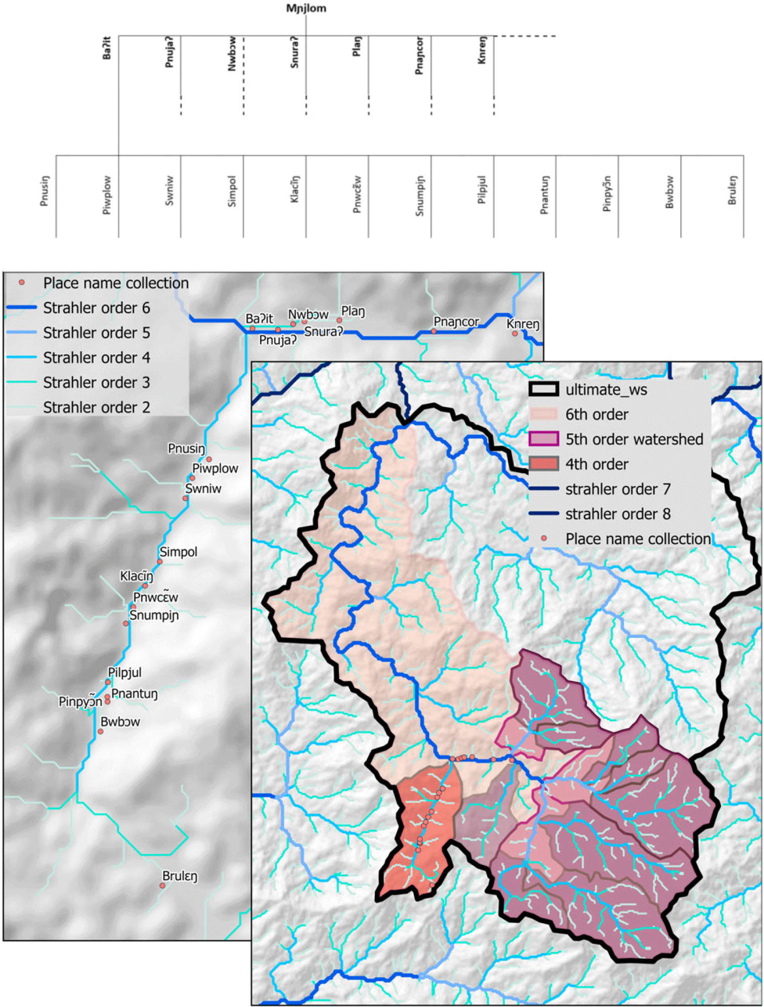
Maps 4 and 5 explore the relationship between cnεl kinship and watersheds associated with streams of different Strahler order. Since we wish to illustrate kinship relationships, we produced a partial family tree based initially on this walk. It appears that all the points along the sixth stream order are referenced as the children of the cnεl Mɲjlom. The point situated farthest downstream is named Baʔit and refers to the area encompassed by the yellow watershed. All the points inside this watershed are identified as the children of Baʔit and grandchildren of Mɲjlom. These grandchildren are associated, according to the ethnographic fieldwork, with permanent trickles of water. However, our DEM resolution of 30 m is too coarse to exactly map such small streams, and we can only draw conclusions about the density of Mɲjlom’s grandchildren with respect to stream catchments and the density of low order streams.
Mnjlom catchment with collected placenames and related kinship.

Having found that the original hypothesis about the naming system could be mapped onto our hydrological attributes, we set out to test other fieldwalks carried out within the area covered by Mɲjlom. We identified 68 placenames collected in five fieldwalks performed during this period (Map 5). All of these points are, by definition, descendants of Mɲjlom, and consulting original field notes confirmed this interpretation. Mɲjlom’s children are located all of the way up one branch of the stream to its headwaters, demonstrating that Strahler order alone cannot fully explain kinship relations, and that it is necessary to first identify the head (associated with a source) of a given cnεl in the field with consultants to fully understand kinship relations. Nonetheless, this map demonstrates that children have systematically lower stream orders than their parents.
The partial family tree, and the incomplete sampling of cnεl names illustrated on our Map 5 are the results of a combination of the ethnolinguistic fieldwork and the use of GIS to explore the systematic use of placenames by the Jahai. The concept of watershed can therefore be used to plan ethnographic work by helping to identify areas where relations between cnεl can be explored. Large catchment areas where no names were collected are obvious locations for future fieldwork if we wish to have a more complete dataset of Jahai placenames, and to test the robustness of our understanding of the underlying naming system and the cnεl origin stories and their relationships to Jahai territory. By doing so, we can start to pose questions for future ethnolinguistic investigations and explore issues with the existing data.
The most obvious of these concerns future data collection in the field. Based on the family tree derived from previous fieldwork in combination with GIS analysis, we can identify potentially interesting regions for data collection. Larger catchment areas (Map 5) associated with empty branches of the family tree (Figure 2) would be good starting points to explore how robust the hierarchical naming system based around the cnεl is.
Family tree with all names collected inside Mɲjlom watershed.

During the data collection, gender associated with cnεl was also recorded. As can be seen in Figure 2, genders seem to be more or less evenly distributed at each generation. However, we find no obvious spatial pattern with respect to gender when we map cnεl names in space, leading us to pose the question of whether there is any underlying systematic way in which gender is assigned aspatially.
Our approach also has some limitations. Most importantly, stream positions have a relatively coarse granularity, as we discussed with respect to the positions of Mɲjlom’s grandchildren. Furthermore, in Map 5 we note a discrepancy between the position of a stream as modeled by the DEM and the actual position as recorded in fieldnotes. This discrepancy indicates the importance of the interplay between field and GIS results.
4. When maps meet myths: the logic of the conceptual system
By projecting the cnεl mythical complex onto a map and relating it to watersheds and Strahler order, we were able to derive a family tree which was consistent with both the Jahai myth and our computer-based representation. Our approach, we believe, thus does not impose a new ontology on the system but rather allows us to explore systematically possible ways in which indigenous placenaming works in a rainforest environment where salient features are typically not visible from long distances.
The firm referential separation of the classes of placenames and landscape terms in Jahai, even if unusual, shows its utility in several situations. First, it provides an efficient conceptual system since it combines unique names unambiguously, a main motivation of placenaming systems (Taller de Tradición Oral & Beaucage, Reference de Tradición Oral and Beaucage1996). Few duplicates (13) were found in the existing data, but even without their location and only through their kinship relationship or their gender they become unique. Indeed, by seemingly associating cnεl with watershed boundaries, a hierarchical structure is created that can be related to salient properties of the environment. Further, as Hollis and Valentine (Reference Hollis and Valentine2001) highlighted, the cognitive process of remembering either placenames or person names is equivalent, since both are pure referring expressions relating to unique referents. In an oral society, where knowledge is “incorporated” as cultural knowledge and not “inscribed” in written texts (Rundstrom, Reference Rundstrom1995), using a system of knowledge that focuses on individual names and kinship makes sense.
Second, through kinship, the Jahai can refer to areas at multiple scales. Their hierarchical system allows references to space to vary in granularity according to whether they refer to a parent, a child, or a grandchild. We can also assume that knowing kinship provides implicit information about watershed size and thus the physical extent of the referent.
Third, this principle is also very efficient when members of the two classes are combined. By using associative phrases, noun phrases in which combined nominal elements can express a range of semantic relations, such as possession, contiguity, proximity, and part/whole relationships (Burenhult, Reference Burenhult2008:186), finer granularity locations can be communicated. Thus, cnεl names can be combined with landscape or body-part terms to create exact references to a feature or a particular cnεl area, as in kuy Cɔs ‘Cɔs’s head’ (meaning the upper part of the cnεl named Cɔs) or jlmɔl Cɔs ‘Cɔs’s mountain(s)’ (a mountainous feature above the cnεl). It may be tempting to analyze these associative constructions as the “real” place names, and indeed the combined forms can appear structurally, semantically, and referentially similar to those of more familiar toponymic systems such as that of English. But that misses the point of keeping the two systems apart, namely, the efficiency of having a semantic engine which productively generates combinations of specifics and generics for flexible, systematic, and unambiguous reference in large-scale space. In this case, a basic template based on properhood serves as a grid onto which landscape complexity is superimposed and straightforwardly referred to in a highly productive way. Besides, there is structural and interactional evidence in favor of treating the constructions as productive phrases rather than frozen proper noun compounds. For example, given the right pragmatic circumstances, the cnεl constituent of the phrase can be (and frequently is) replaced by the third-person singular pronoun ʔoʔ ‘he/she/it’: kuy ʔoʔ ‘its head,’ tɔm ʔoʔ ‘its stream,’ and so on.
5. Conclusions
In applying GIS to indigenous systems of landscape representation, there is good reason to be concerned about the imposition of inappropriate models. However, in our view, these hazards essentially arise from conceptual limitations, not technological ones. We believe that an interdisciplinary approach involving a combination of ethnographic, linguistic, and GIS perspectives, developed in close consultation with the community under study, can make considerable headway in the documentation and analysis of indigenous landscapes. In this paper, we have demonstrated that combining ethnographic and linguistic field data with GIS can offer a fascinating and productive way of not only exploring landscape systems but also generating hypotheses for future investigation in the field. Careful mapping of linguistic categories in the form of placenames has allowed us to develop a socioculturally attuned model of representation that, rather than misrepresenting indigenous categories and knowledge, actually helps us understand and document such categories and knowledge in greater depth and opens up opportunities for analytical ways forward. We would like to underscore the highly abstract referential principles that underlie the Jahai placenaming system, structured by notions of mythological animacy and kinship and unusually detached from the observable landscape. Despite these intangible characteristics, we have been able to identify and map their subtle geographical correlates, and we have developed a GIS-generated model for deeper exploration of Jahai myth and worldview.
Digitized models of landscape systems may also raise issues of preservation, reproduction, and widespread sharing of indigenous geographical representations and knowledge (Cogos et al., Reference Cogos, Roué and Roturier2017; Rundstrom, Reference Rundstrom1991). Needless to say, close collaboration with communities is required in order to develop strategies for avoiding undesired ramifications of such records and for promoting desired outcomes. Here it is important to recognize that communities, just like their systems of landscape representation, are tremendously diverse and that aspirations, concerns, and sensitivities need to be addressed on a community-specific basis. On the basis of our experience of working together with the Jahai community, we concur with Robbins (Reference Robbins2003) that, used appropriately, records can be employed to document, preserve, and promote indigenous heritage in a way that is of benefit to researchers and community alike. Strong and longstanding community support for documenting and sharing Jahai language and culture has been crucial to the research reported here. Conversely, the mapping of Jahai placenames has stimulated particular community interest in the research process and offered new opportunities of community involvement in the documentation program. We believe the model we have developed here will be of great help to researchers and community members alike in the future pursuit of this fascinating system.
Acknowledgments
Special thanks to Burenhult’s Malaysian sponsor Associate Professor Hajjah Rogayah A Razak, Universiti Kebangsaan Malaysia; to the Ministry of Economic Affairs, Putrajaya, and the Department of Orang Asli Development, Kuala Lumpur, for permission to conduct research; and to the Jahai community of Sungai Banun. Burenhult’s research was supported by the European Research Council under the EU’s Seventh Framework Programme (FP7/2007-2013)/ERC grant agreement 263512; and a Bank of Sweden Tercentenary Foundation Jubilee Initiative Grant and Infrastructural Grant (NHS14-1665:1; IN17-0183:1). Villette and Purves acknowledge support from the Swiss National Science Foundation and the Canton of St. Gallen (SNF project no. 100015_182626).


 Open access

