


Introduction
Armavir is among the most significant archaeological sites in Armenia. Located on the edge of the Araks Valley, it once stretched for approximately 3.5km, making it one of the largest archaeological complexes in the country (Figures 1 & 2). Although founded in a fertile region, irrigation was required to render the land arable—a practice introduced under Urartian rulers (c. 786–590 BC).
Location of study area. A/B) ESRI National Geographic; C) open topo maps; D) modern Bing satellite imagery (figure by N. Buławka).

Argishtikhinili viewed from the north (photograph by K. Jakubiak).

During the reign of King Argishti I (786–764 BC), the Araks Valley was brought under Urartian control and the fortress of Argishtikhinili was constructed, strategically positioned between two natural elevations, each crowned by a citadel—one for political authority, the other religious purposes (Martirosyan Reference Martirosyan1974). According to the Sardarabad/Armavir (CTU A 8-16) and Karakala/Armavir (CTU A 8-15) inscriptions, dating from its foundation, five irrigation channels conveyed water to the urban core and the surrounding fields, gardens and vineyards (Salvini Reference Salvini2008). An inscription on a stone stele from this period notes that the land had previously lain fallow, suggesting water scarcity inhibited settlement. Archaeological surveys corroborate the absence of earlier habitation.
The later history of the irrigation system remains less clear. It likely continued in use until the fall of Urartu around 590 BC. During the Hellenistic period (323–30 BC), the foundation of Armavir saw irrigation restored (Karapetyan et al. Reference Karapetyan, Bobokhyan and Avetisyan2021). Some canal sections may be remnants of earlier systems. Although minor cultivation may have occurred under the Achaemenids (550–300 BC), the lack of evidence for rural settlement during this time argues against extensive use. Modern villages may occupy ancient settlement locations, suggesting the surviving irrigation network includes both Urartian and Hellenistic elements. Later activities are also possible as Armavir continued to flourish into the medieval period (up to the twelfth century), indicating that the irrigation system evolved over generations. Today, the region remains agriculturally active, with canals, pipelines and pumping stations shaping modern irrigation. The current project examines the landscape around Argishtikhinili, aiming to find elements of an irrigation network from the Urartian period (mid-ninth century–590 BC).
Materials
This study used Landsat 5 multispectral and Sentinel-1 synthetic aperture radar (SAR) data, available as a multitemporal image collection via Google Earth Engine (Gorelick et al. Reference Gorelick2017). Archival CORONA KH-4B (1971, 1.8m) and GAMBIT (1966, 0.6–1.2m) satellite images were accessed through the United States Geological Survey’s EarthExplorer or the Corona Atlas & Referencing System. Elevation data included the TanDEM-X 30m edited digital elevation model (EDEM) and Euro-Maps 3D digital surface model (DSM) (5m) (Uttenthaler et al. Reference Uttenthaler2013; González et al. Reference González2020).
Methods
Archaeological exploration of the Argishtikhinili vicinity began in 2013, initially focusing on Metsamor, then areas further west from 2024. Remote sensing was used to detect ancient water-management features. Archival CORONA and GAMBIT images revealed irrigation layouts prior to modern development (Fowler Reference Fowler2008; Ur Reference Ur, Comer and Harrower2013).
Landsat 5 imagery was processed using seasonal multi-temporal vegetation indices (SMTVI) and tasselled cap transformation (TCT). Sentinel-1 SAR images produced seasonal composites via VH-band backscatter averages. Elevation data were analysed with a multi-scale relief model (MSRM), enhancing visibility of terrain features of varying scale (Orengo & Petrie Reference Orengo and Petrie2017, Reference Orengo and Petrie2018) (Figure 3). Rasters and archival images facilitated identification of levees and palaeochannels, digitised in ArcGIS Pro (v.3.4.0) at a scale of 1:10 000. Feature segments were simplified to remove minor lines, enabling clear mapping of ancient and modern irrigation elements.
The study area shown as: A) a TanDEM-X 30m EDEM (fmin 30, fmax 3000, grayscale); B) an MSRM (EM3D DSM, fmin 5, fmax 3000, colour scale) (figure by N. Buławka).

Results
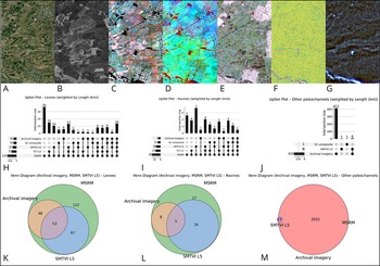
The study mapped 1019.05km of water-management features, focusing on ancient levees and palaeochannels. Two palaeochannel types were distinguished: incised channels (ravines), visible in terrain relief, and other palaeochannels, identifiable via soil discoloration or vegetation patterns. Modern canals accounted for 428.9km of identified features, former mountain or Araks stream beds for 419.6km, incised palaeochannels for 36km, and potential ancient canals for 134.6km, primarily around Argishtikhinili (Figure 4).
Visibility of water-management features around Argishtikhinili: A) Bing imagery; B) GAMBIT imagery; C) SMTVI (May–October); D) TCT dry season; E) Sentinel-1 VH band seasonal composite; F) MSRM composite (Euro-Maps 3D, fmin: 5, fmax: 60); G) MSRM composite (Euro-Maps 3D, fmin: 5, fmax: 240, fmin: 5, fmax: 480, fmin: 5, fmax: 960); H & K) levees; I & L) ravines; J & M) other palaeochannels (figure by N. Buławka).

GAMBIT imagery facilitated discrimination between modern and older features, although meander-shaped modern canals likely followed older courses. Most palaeochannels, particularly those suggested by soil or vegetation, were confirmed via GAMBIT imagery (98%), with minor exceptions detectable via SMTVI (1.5%).
Incised palaeochannels were primarily recognised from elevation data, with 14% visible only in MSRM. Others were identifiable across various sources. Levees were mostly elevation-derived, with 36% detected solely in MSRM, while others appeared when MSRM was combined with TCT, SMTVI or all datasets (approximately 10%).
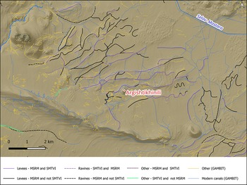
The area east of Argishtikhinili features meander-shaped levees, possibly crevasse splays from branches of the Araks, while some straight segments reflect modern irrigation modifications (Figure 5). Similar irrigation patterns exist in the southern Ararat Plain (Türkiye), while the absence of irrigation relief in parts of the northern and eastern plain may reflect different settlement and irrigation histories. Neotectonic activity, low slopes and riverbed migration shaped the landscape, influencing preservation of canals and settlements. Modern mechanised agriculture further obscures subtle topographic evidence, complicating field surveys.
Comparison of digitised water-management features identified using vegetation indices (SMTVI), relief models (MSRM) and GAMBIT imagery (figure by N. Buławka).

Conclusion
Argishtikhinili’s surroundings offer unique insight into ancient Ararat Plain water management. Landscape analysis indicates potential Urartian canals, that may confirm the region’s critical role under Argishti I. Canals enabled intensive agriculture from Urartu through antiquity, with frequent repair and expansion. Most levees align north-east, suggesting connections to dry stream beds or larger water infrastructure, potentially sourcing water from the Araks River.
These findings demonstrate the importance of engineered irrigation in shaping the Ararat Plain’s agricultural landscape (Figure 6), though further, detailed investigation is required as many of the canals were likely constructed later (Çifci & Greaves Reference Çifci and Greaves2013). More data are needed to precisely date the irrigation system and to determine the chronology of the associated settlements.
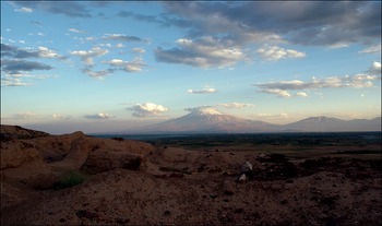
View of the Ararat mountain and Arat Plain from Argishtikhinili (photograph by K. Jakubiak).

Funding statement
Euro-Maps 3D DSM (5m) was granted by the European Space Agency project proposal number PP0098024 (2024).
Data availability statement
Data are available from the corresponding author upon request.
Author contributions: CRediT categories
Nazarij Buławka: Conceptualization-Equal, Data curation-Equal, Formal analysis-Equal, Funding acquisition-Equal, Investigation-Equal, Methodology-Equal, Resources-Equal, Software-Equal, Visualization-Equal, Writing - original draft-Equal, Writing - review & editing-Equal. Krzysztof Jakubiak: Conceptualization-Equal, Formal analysis-Equal, Project administration-Equal, Resources-Equal, Supervision-Equal, Validation-Equal, Visualization-Equal, Writing - original draft-Equal, Writing - review & editing-Equal. Inessa Karapetyan: Formal analysis-Equal, Investigation-Equal.


 Open access