


Highlights
• Zostera marina was a once abundant species occurring on Northern Ireland’s coasts.
• Zostera marina was first used as a resource in Northern Ireland in the early 1800s.
• Zostera noltei was first recorded in Northern Ireland, in Dundrum Bay in 1914.
• Seagrass populations have not recovered to the levels observed before the 1930s.
• Due to foreshore development, seagrass is no longer present in Belfast Lough.
Introduction
Seagrasses are marine flowering plants, forming expansive meadows in shallow-subtidal and intertidal coastal zones and spanning a range of six global bioregions from tropical to temperate seas (Short et al., Reference Short, Carruthers, Dennison and Waycott2007). As ecosystem engineers, seagrasses alter their environment in turn providing a range of ecosystem services, including coastal protection, supporting fisheries, enhancing biodiversity, improving water quality, and nutrient cycling (see overview of benefits in Gamble et al., Reference Gifford2021). Recognised as a vital blue carbon habitat due to their ability to store and sequester significant amounts of CO2, seagrasses are considered as a nature-based solution through mitigating climate change and providing coastal resilience (Do Amaral Camara Lima et al., Reference Drennan2023; Unsworth et al., Reference Waddell2022a).
Despite their ecological importance, seagrasses are increasingly threatened by a combination of anthropogenic and environmental stressors (Orth et al., Reference Platts2006; Stockbridge et al., Reference Strachan, Lilley and Hennige2020; Waycott et al., Reference Wear and Lloyd Praeger2009). Between 1869 and 2016, around one-third of European seagrass areas were lost, primarily due to factors such as disease, declining water quality, and coastal development (de Los Santos et al., Reference de Los Santos, Krause-Jensen, Alcoverro, Marbà, Duarte, van Katwijk MM, Pérez, Romero, Sánchez-Lizaso, Roca, Jankowska, Pérez-Lloréns, Fournier, Montefalcone, Pergent, Ruiz, Cabaço, Cook, Wilkes, Moy, Muñoz-Ramos Trayter, Arañó, de Jong DJ, Fernández-Torquemada, Auby, Vergara and Santos2019). Overall Zostera noltei and Z. marina experienced the greatest proportion of area decline in seagrass sites across Europe, however a trend reversal in 2000s showed the recovery of Zostera spp. (de Los Santos et al., Reference de Los Santos, Krause-Jensen, Alcoverro, Marbà, Duarte, van Katwijk MM, Pérez, Romero, Sánchez-Lizaso, Roca, Jankowska, Pérez-Lloréns, Fournier, Montefalcone, Pergent, Ruiz, Cabaço, Cook, Wilkes, Moy, Muñoz-Ramos Trayter, Arañó, de Jong DJ, Fernández-Torquemada, Auby, Vergara and Santos2019). In the United Kingdom, it is estimated that, since 1936, 44% of seagrasses have been lost and 39% of that occurred since the 1980s (Green et al., Reference Hart2021). Understanding the distribution patterns, underlying drivers, and magnitude of this decline is imperative for the conservation of the ecosystem services that seagrasses provide (Cullen-Unsworth et al., Reference Cullen-Unsworth, Nordlund, Paddock, Baker, McKenzie and Unsworth2014; Duarte et al., 2008).
In Britain, the 17th and 18th centuries saw significant coastal development activities during industrialisation, such as land reclamation, dredging, and heavy metal pollution in estuarine waters causing environmental degradation (Green et al., Reference Hart2021). The degradation was further echoed in Northern Ireland during the 19th century (Lloyd Patterson, Reference Lloyd Praeger1889). The situation for seagrass worsened across the UK with losses further exacerbated during the 1930s with the emergence of the seagrass wasting disease Labyrinthula zosterae (Lynn, Reference Lynn1936). As coastal populations, human activities on the coast, and land development continue to grow, existing threats have intensified and are expected to increase (Duarte, Reference Duarte, Dennison, Orth and Carruthers2002). Consequently, Europe, particularly the Northern British Isles, is predicted to be one of the most vulnerable regions at high risk of seagrass loss due to these pressures (Turschwell et al., Reference Unsworth, Furness and Rees2021).
The decline and threat of seagrass habitats in the UK has prompted efforts to restore the lost and degraded seagrass meadows (Gamble et al., Reference Gifford2021; Green et al., Reference Hart2021). Large-scale seagrass restoration efforts have occurred in the Dale, Pembrokeshire followed by recent seagrass planting efforts in the Humber, England (Lincolnshire Wildlife Trust, Reference Lloyd Patterson2023; Unsworth et al., Reference Unsworth, Cullen-Unsworth, Jones and Lilley2022b). While these initiatives are significant and essential, when comparison is made with international restoration efforts, the UK’s overall response can be considered inadequate. A limiting factor in the progression of seagrass restoration in the UK is a lack of information in several areas; monitoring indicators, management protocols, protection measures, and restoration techniques (Strachan et al., 2022).
Seagrass meadows in Northern Ireland are typically distributed throughout sheltered coastal embayment’s and all sea loughs apart from Belfast Lough, with Zostera marina (eelgrass) predominantly found in the subtidal and Z. noltei (dwarf eelgrass) in the intertidal. Biotopes created by these species were recognised as a priority feature in 2003 with a tailored habitat action plan for seagrass beds; however, it was not feasible to produce specific targets due to a lack of baseline information on the extent, quality, and distribution of seagrass (Department of Agriculture, Environment and Rural Affairs [DAERA], 2003). Monitoring of seagrass meadows has primarily been episodic rather than systematic, making it difficult to gather reliable data on the spatial and temporal changes as well as the ecological condition of these habitats.
In contrast to Wales, England, and Scotland, Northern Ireland currently has no active seagrass restoration efforts. However, in 2024, the local government started consultations on the Blue Carbon Action Plan and Marine Protected Area (MPA) Strategy Review, both of which address the status of seagrass, including protecting, enhancing, and restoring the habitat (DAERA, 2024a, b). Recognition of seagrass habitats and their associated ecosystem services has led to an eagerness from local eNGOs and councils to begin efforts to protect, manage and restore seagrass meadows (Strangford Lecale AONB, Reference Swanston2023). As is the case with many ecological restoration projects, obtaining permissions or licences for novel plans and techniques is difficult without the backing from governmental departments. The use of historic records has proved a fundamental first step when gathering evidence to support restoration efforts for priority habitats (Hayden-Hughes et al., Reference Hayden-Hughes, Bayford, King and Smyth2023; Kirkpatrick et al., 2024). It is envisaged that the historical overview of seagrass in Northern Irish waters presented in this manuscript will greatly aid future seagrass restoration programmes.
Materials and methods
Ireland was partitioned by the Government of Ireland Act 1920, establishing Northern Ireland as a part of the United Kingdom. This historical account focuses on records of seagrass specific to Northern Ireland, but relevant references from the Republic of Ireland particularly pre-1921 have been included when appropriate for broader context (Table 1). Northern Ireland has five sea loughs with both Carlingford and Foyle loughs being termed as border loughs, all of which have historically supported seagrass beds (Figure 1).
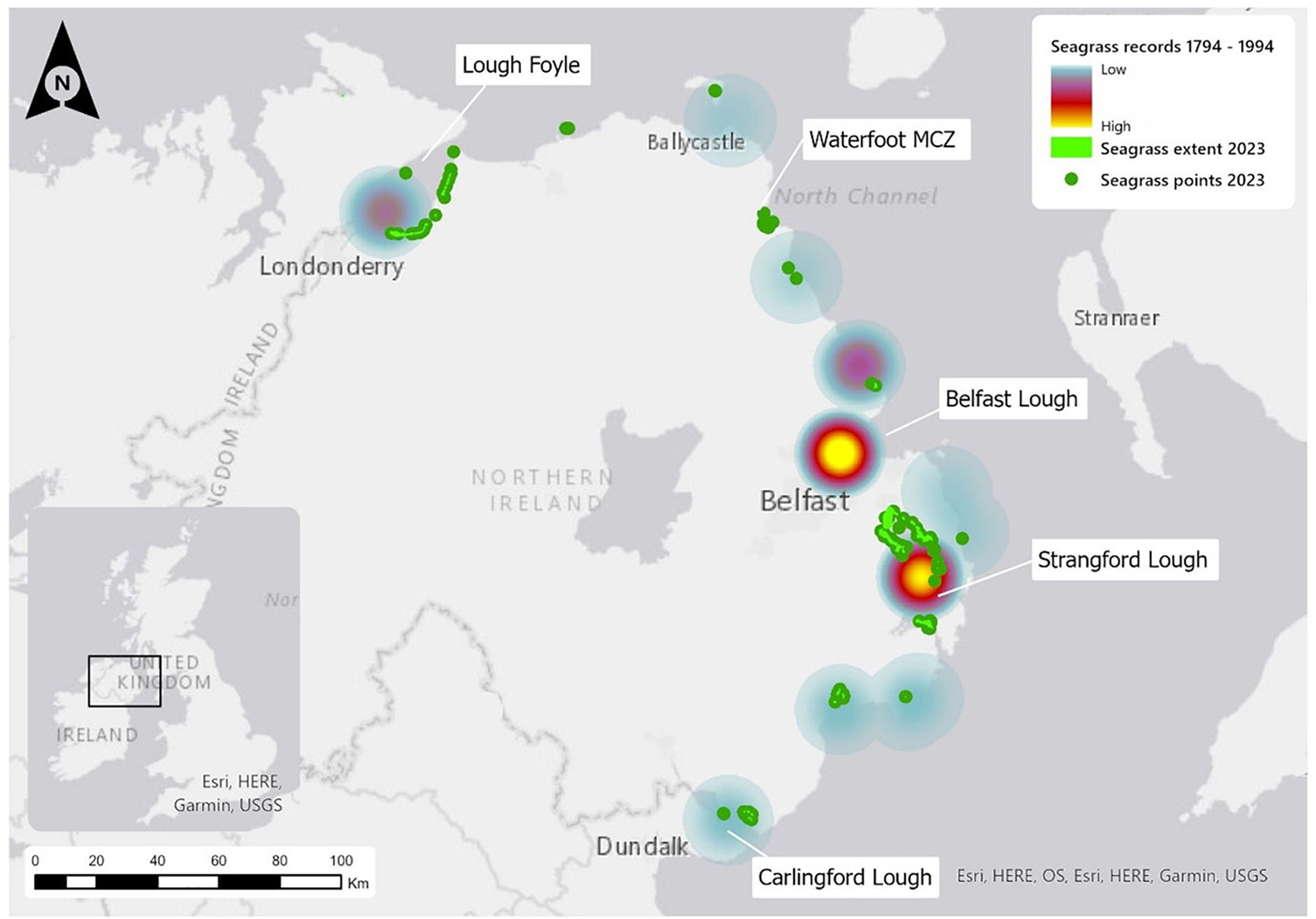
Records of seagrass from 1794 to 1994 overlaid with the known distribution and extent of seagrass in 2023 (emodnet seabed habitats) across Northern Ireland featuring key locations. Map lines delineate study areas and do not necessarily depict accepted national boundaries. Arcgis pro (version 3.1.2).
A historical timeline of Zostera divided into three periods: ‘extensive and dense seagrass meadows’, ‘degradation’ and ‘signs of recovery’
Digital and physical literature was reviewed to create a timeline documenting the history of seagrass in Northern Irish waters. Online sources such as the Biodiversity Heritage Library, The National Archives of Ireland and online scientific journals were used, employing the following key search terms; Z. marina, Z. nana, Z. noltei, Z. noltii, Zostera, Zostera banks, Eelgrass and Seagrass. Overall, greater than 300 documents were found across library collections, national archives, historical naturalist societies, government reports, marine taxonomic lists, peer-reviewed literature, and textbooks. However, only approximately 70 references were used in this paper.
It was discovered during the review of documents that the terminology used to refer to species of Zostera changed over time. Therefore, additional searches were undertaken using colloquial keywords such as ‘Sleech’, ‘Sleech grass’, ‘Grass wrack’, ‘Sluch’, and ‘Slitch’. Physical collections from the Linen Hall Library, the National Museums NI Library, and the Public Records Office NI were searched online prior to visiting the archival records. If key words and documents of interest were identified in-situ confirmation was conducted in person. Results were then compiled into a historical timeline (Table 2), which revealed distinct periods within the timeline relating to the health and condition of seagrass in Northern Irish waters. Individual records of Zostera presence were also summarised into a heat map (Figure 1), whereby the data used was the number of written records for that location. One data point was classed as one event record. For example, if Zostera was recorded on the 29th of March 1835 and the word ‘Zostera’ was mentioned five times in the text, we would have recorded that as one data point if it was all referring to the same location.
Other data sources used to support distribution data not included in reference list
Results
All documents which appeared in our searches were examined. Those which were relevant to this study which related to Northern Ireland or to the spread of Zostera noltei to Northern Ireland, were included. Some documents had been republished or recirculated. In this instance, only the original document or record was counted to avoid duplication.
Table 2 presents an overview of key historical references of Zostera, revealing two significant locations: Belfast Lough and Strangford Lough (see Figure 1). Within these two sea loughs, there are varying degrees of decline of seagrass which is linked to the use of the lough and its prominence in the industrial revolution. For example, most of the early historical records of seagrass relate to those in Belfast Lough, however with increased pressure associated with a rising population in Belfast and use/development of the lough and surrounding areas during the industrial period, the seagrass habitats declined with no records of seagrass present there today (Figure 1).
The research revealed three distinct periods of seagrass condition that determined the conservational health of seagrass, and the authors have used this to divide the timeline results into ‘Extensive and Dense Seagrass Meadows’, ‘Degradation’, and ‘Signs of Recovery’.
The majority of records that we discovered were authored by local naturalists, typically belonging to the local naturalist societies or clubs. These people were the local experts to our understanding and therefore we are confident of the accuracy of these records and additionally, many times, the plant was referred to directly by its Latin name. Many of the records were from observations made intertidally and some were made directly from boats in shallow water. A small number of records were observed through dredging. Whether these dredges were commercial or scientific is not always noted, however, we believe that the Belfast Dredging Committee (Murray, Reference Nelson2003) was responsible for many of these records.
Discussion
The archives revealed three key periods, as outlined in Table 2. They identify seagrass prevalence, decline, and signs of recovery which could be collated into a timeline.
Period 1: Late 1700s to 1880 – Extensive and dense seagrass meadows
The first records of Z. marina specific to Northern Ireland date from the 1790s and place the species on the western shore of Belfast Lough (Nelson, Reference Nichols2003; Stewart and Corry, Reference Stockbridge, Jones and Gillanders1888). In the early 1800s, Z. marina was growing ‘abundantly’ in Belfast Lough and Strangford Lough, often described as growing in ‘masses’, ‘heaps’, and ‘profusely’, to the extent that the shore was defined as having a ‘greenish tinge’ and likened to a ‘green carpet’ (Thompson, Reference Thompson1842, Reference Thompson1849a, Reference Thompson1850).
Accounts of some ground nesting bird species at island locations in Belfast and Strangford Lough were regularly associated with the abundant growth of Z. marina, and it was noted that dried Z. marina was a major component within their nests (Thompson, Reference Thompson1850, Reference Thompson1851). Circa this period, many of the records for Z. marina are recorded due to associated species use, with the plant being viewed as a substrate rather than the main organism of interest. Seagrass-related species included ascidians, bryozoans, hydrozoans, marine macroalgae, gastropods, and several fish species (Fisher and Templeton, Reference Fisher and Templeton1935a,Reference Gamble, Glover, Debney, Bertelli, Green, Hendy, Lilley, Nuuttila, Potouroglou, Ragazzola, Unsworth and Prestonb; Gifford, Reference Green, Unsworth, Chadwick and Jones2021; Thompson, Reference Thompson1840, XXVIII and XI, Reference Thompson1849b, Reference Thompson1850, Reference Turschwell, Connolly, Dunic, Sievers, Buelow, Pearson, Tulloch, Côté, Unsworth, Collier and Brown1856).
A sympatric relationship between seahorse species and seagrass meadows has been recorded throughout the temperate regions, with correlations between abundance and available vegetation (Curtis et al., Reference Curtis, Amanda and Vincent2005). The Northern Irish coasts in the 1800s once supported an apparently small population of the short-snouted seahorses Hippocampus hippocampus (Yarrell, 1859). Individuals were found washed up at Red Bay, County Antrim in 1821 (Thompson, Reference Thompson1837) – an area designated presently as a Marine Conservation Zone due to its expanse of subtidal seagrass meadow (Department of Agriculture, Environment and Rural Affairs [DAERA], 2016). A single, more recent record occurred in 1921, when a live seahorse was found on the shore of Greenisland, Belfast Lough (Fisher, Reference Fisher and Templeton1926). It was the first record from Belfast Lough since 1837 with no individuals recorded since. We have not found any direct evidence which linked the decline in seagrass quality and extent in Northern Ireland with the decline of seahorses. However, the occurrence of seahorses in the region coincided with the period of healthiest seagrass populations and further literature review has suggested that the records mentioned above are the only ones from this region.
During this 1st period, Z. marina was recorded as growing on mudflats, in parts of sea loughs which had ‘oozy’ sediment (Thompson, Reference Thompson1850), where it grew intertidally to the extent that large patches of the plant were often visible at low tide (Thompson, Reference Thompson1849a, Reference Thompson1850). Larne, Belfast and Strangford Lough are all mentioned as having ‘extensive muddy Zostera-covered banks’ (Thompson, Reference Thompson1850).
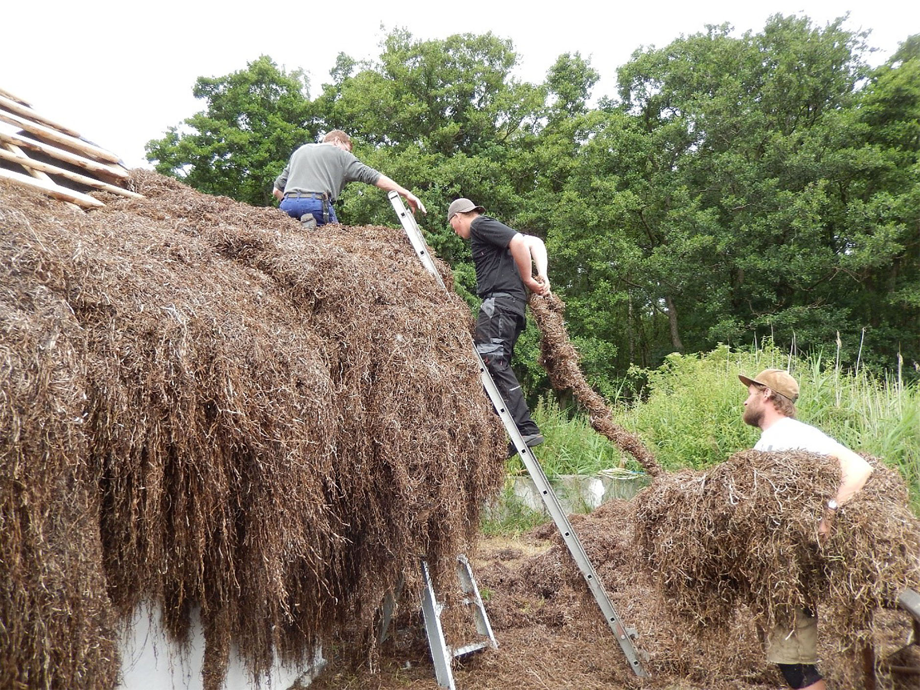
Uses for Z. marina were being developed during the latter end of period 1, as low cost, easily obtained material was utilised to meet the demands of industrial development. Throughout the UK seagrass species were commonly used for thatching roofs particularly within coastal communities with a ‘sea-grass thatch’ (Figure 2), which was said to last for 100 years (Pratt, Reference Pratt1850). No evidence was found to suggest that thatching using seagrass was a commercial activity.
Example of a seagrass thatched roof on a Danish House Ⓒ visitlæsø.
It was also frequently used as a stuffing for mattresses, often preferred over hay or straw and was sold in shops for filling cushions and other upholstery items, under the name of ‘Ulva marina’, ‘Alva marina’, or ‘Alva’ (Pratt, Reference Reid, Stone, Coyle, Grimes and Montgomery1905; Wood, Reference Yarrell1860). Seagrass was a common packing material for glass bottles and earthenware in transit and the packing of choice for Italian liquor-casks (Horwood, Reference Johnson and Hensman1919; Pratt, Reference Pratt1850, Reference Reid, Stone, Coyle, Grimes and Montgomery1905). During this period, the concept of using seagrass as a commercial product in Northern Ireland was being explored. In 1829, A. MacDougall wrote to William Lamb, Chief Secretary, to inquire as to the best method for acquiring a patent for the ‘preparing, dressing, and manufacturing, of the Ulva Marina Zostera or Sea Grass’ (Appendix, Transcript 1). The intended use was described as the stuffing of ‘mattresses, cushions and other useful purposes’ with the price of a seagrass mattress being ‘from 3s to 6s and upwards’, where ‘s’ is shillings (MacDougall, Reference McCutcheon’s1829).
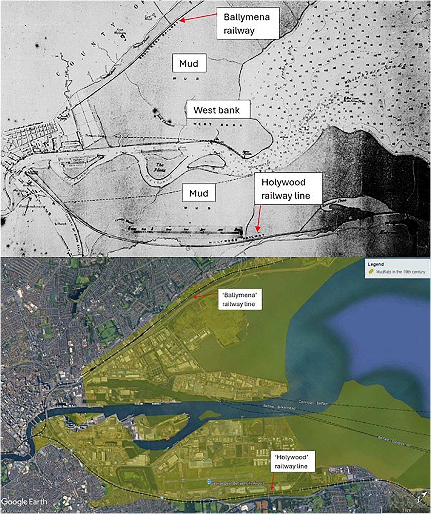
In the 1840s, seagrass was also considered an important food source for harvestable wildfowl. Brent geese were noted to move to Belfast Lough from Strangford Lough around March, as they were presumed to have exhausted the Zostera beds in Strangford Lough, with the author referring to the meadows as ‘closely cropped’ (Thompson, Reference Thompson1851). An example of industrial development having an impact on seagrass habitat was recorded in the 1840s when the County Down Railway Company constructed the Holywood section of the railway line, reclaiming parts of the shore, embanking east from the Conn’s Water estuary up to the area opposite the Palace grounds (Figure 3; McCutcheon’s, Reference McMillan1980). Thompson (Reference Thompson1851) referred to the recently constructed railway embankment on the western shore of Belfast Lough which involved extensive land reclamation and as a result, ‘fields of corn now wave where banks of Zostera once prevailed’. These are the earliest references we have, which describe contributions to the structural changes that have altered Belfast Lough over the last 200 years (Lloyd Praeger, Reference Lloyd Praeger1904b). Another example is that of the expansion of the Victoria Channel through dredging, which facilitated an increased tidal influence over the mudflats, removing the surface layer of mud and with it the seagrass near Holywood (Praeger, Reference Pratt1920; Swanston, Reference Thompson1870).
A 19th century map of Belfast Lough showing the vast mudflats, annotated to improve readability Ⓒ BELUM.Y4962 map of Belfast and Lough. Late 15th century, A. R. Hogg courtesy of national museums NI Ulster Museum Collection. Shown against a Google Earth image of the same location, with the shaded area showing the historical extent of mudflats © Google Earth pro 6.2.1.6014, 2024, Belfast Lough, data: SIO, NOAA, U.S. Navy, NOA, GEBCO, accessed 14 March 2025.
From the historical records, Z. marina and Z. angustifolia appear to be the only seagrasses present in Ireland until Z. noltei (referred to as Z. nana) was recorded in 1864 for the first time in Dublin Bay (Baker and Foggitt, Reference Baker and Foggitt1865). It began to be included in ‘Lists of Desiderata’ in Irish naturalist journals along with Z. marina and ‘Z. angustifolia’ (Baker and Foggitt, Reference Baker and Foggitt1865). Records of Z. nana continued to be sought after by Irish naturalist journals, being described as a ‘rare Irish native plant’ (Hart, Reference Horwood1887). In 1866, Z. marina continued to be listed as ‘common’, while Z. nana was described to be found along the east coast of Ireland in muddy estuaries but being very rare (Moore and Goodman More, Reference Moore, More, Colgan and Scully1866). It was described as growing amongst ‘Z. marina, var. angustifolia’ (Moore and Goodman More, Reference Moore, More, Colgan and Scully1866).
By the late 1800s, Z. marina in Belfast was still thought to be healthy and extensive (Nichols, Reference Orth, Carruthers, Dennison, Duarte, Fourqurean, Heck, Hughes, Kendrick, Kenworthy, Olyarnik and Short1899) as brent geese feeding in these locations were all found to have, often exclusively, Z. marina in their gut with similar results from other birds (Thompson, Reference Thompson1851). There was a parallel situation in Strangford Lough, where there was ‘Zostera in abundance’ with a variety of marine organisms continuing to be found growing on the blades (Balfour, Reference Balfour1854; Carpenter et al., Reference Carpenter, Halbert, Johnson, Nichols, Lamont Orr, Patterson, Lloyd Praeger, Scharff, Welch and Wright1902; Thompson, Reference Thompson1851, Reference Turschwell, Connolly, Dunic, Sievers, Buelow, Pearson, Tulloch, Côté, Unsworth, Collier and Brown1856) and Z. marina was also noted in Lough Foyle and Fairhead (Lloyd Praeger, Reference Lloyd Praeger1889). It was around this period that Z. marina began to be referred to as ‘eel-grass’ (Clark, Reference Clark1863).
The early decline in Northern Ireland’s seagrass meadows is highlighted within references from 1840. Most of the disturbance can be attributed to anthropogenic activity, with the majority of habitat impacts related to coastal development projects or increased resource use from a rapidly growing population. This second period is being classed as beginning when consistent degradation due to the dredging of the Victoria Channel was observed. In the cases of the earlier damage due to embankment, these are considered individual damage events as opposed to a consistent new pattern and therefore have not been chosen to define a new period.
Period 2: 1880 to 1940 – Degradation
Naturalists in the early 1900s began to describe changes along the banks of Belfast Lough on the County Down shore, documenting that the former ‘great expanse of banks’ which were covered with Z. marina had changed from ‘soft ooze’ to ‘hard and clean sand banks’ (Lloyd Patterson, Reference Lloyd Praeger1889). Patches of Zostera and mud banks ‘vanished’ and blue mussels were seen for the first time starting to grow intertidally (Thompson, Reference Thompson1895). This was attributed to the developments that came with improvements to Belfast Harbour, culminating in the Victoria Channel, but particularly the dredging of the ‘new cut’. It was said to have ‘diverted the former flow of the tide and the river’ and by ‘making an increased “scour,” gradually swept the mud or ooze off the banks, and with it the Ribbon or Grass Wrack (Zostera marina) that grew on it’ (Lloyd Patterson, Reference Lloyd Praeger1889). Other industrial processes were applying similar pressures onto seagrass communities, such as in mud flats within Larne Lough at Magheramorne, Co. Antrim. The mud was considered to still be able to support living Z. marina, if it were not for the advancement of a large ‘spoil bank’ from nearby chalk quarries into the sea, raising the height of the clay by several feet above the high-water mark (Lloyd Praeger, Reference Lloyd Praeger1892).
While declines in seagrass populations were particularly noted close to areas of industrial development, healthy seagrass meadows continued to be recorded in less developed areas and in some locations, it was actively expanding. Lloyd Praeger (Reference Lloyd Praeger1892) recorded Z. marina in Carlingford Lough and it was observed that it was to be found on the ‘coasts of all Ireland’ including County Down, Antrim and Derry (Carpenter and Lloyd Praeger, Reference Carpenter and Lloyd Praeger1897; Carpenter et al., Reference Carpenter, Halbert, Johnson, Nichols, Lamont Orr, Patterson, Lloyd Praeger, Scharff, Welch and Wright1902; Johnson and Hensman, Reference Kirkpatrick, Millar and Smyth1895; Lloyd Praeger, Reference Lloyd Praeger1901; Moore et al., Reference Murray1898). Zostera banks were spoken of from Larne Lough and Strangford Lough, particularly near Newtownards and the Comber River estuary and Belfast Lough, Lough Foyle, and Fairhead (Lloyd Praeger, Reference Lloyd Praeger1889, Reference Lloyd Praeger1892). The plant was often dredged from ‘a depth of several fathoms off Glenarm’ and was described as found closer to the low water mark but still listed as common (Stewart and Corry, Reference Stockbridge, Jones and Gillanders1888). The smaller species, Z. nana, continued to spread around the coasts of Ireland with findings initially classed as a ‘rare’ or ‘valuable record’ in papers but records remained isolated to the Republic of Ireland (Carpenter and Lloyd Praeger, Reference Carpenter and Lloyd Praeger1897; Hart, Reference Horwood1887; Moore and Goodman More, Reference Moore, More, Colgan and Scully1866). During the 1900s, a shift in nomenclature was apparent with ‘Zostera’ starting to be referred to as Sea-Grass/sea grass (Carpenter and Lloyd Praeger, Reference Carpenter and Lloyd Praeger1897; Clarke, Reference Clarke1865).
Seagrass losses were not always attributed to coastal development; indeed, ‘Masses of decaying Zostera’ were noted locally in Strangford Lough in 1903 (Lloyd Praeger, Reference Lloyd Praeger1904a). However, this occurred between the two recorded ‘wasting epidemics’ suggesting this may have been due to a locally damaging event such as pollution or disease. As seagrass continued to decline, it’s role in coastal protection began to be understood. The absence of Z. marina in parts of Belfast Lough began to be felt, as ‘the formerly softening effect’ of the Zostera meadows was no longer there to prevent the full force of the waves breaking on the beach and sea walls, resulting in a more rapid degradation of the shoreline (Lloyd Praeger, Reference Lloyd Praeger1904b). The role of seagrass as a sediment trap also began to be recognised during this period as it was suggested that it contributes to clay formation (Lloyd Praeger, Reference Lloyd Praeger1892). The effects of these changes on local animal life were also noted, including a local decline in wading birds (Lloyd Praeger, Reference Lloyd Praeger1904b).
As Zostera nana continued to be recorded in new locations, it was listed as ‘very rare’ with its centre of distribution lying ‘further south in Ireland’. It was first recorded in Northern Ireland at Dundrum Bay in 1914 and again at Strangford Lough in 1916 (Wear and Lloyd Praeger, Reference Wilkes, Bennion, McQuaid, Beer, McCullough-Annett, Colhoun, Inger and Morrison1923). Zostera marina and its variation angustifolia were growing ‘in great masses’ in the area with washed up blades referred to as ‘sleech’. These detached blades were collected from mounds on the shore and used to cover potato bins during the winter, locally (Waddell, Reference Waycott, Duarte, Carruthers, Orth, Dennison, Olyarnik, Calladine, Fourqurean, Heck, Hughes and Kendrick1917).
Localised and widespread degradation of the seagrass beds throughout Northern Ireland began to be described in the 1930s (Cotton, Reference Cotton1933; Lynn and McGurk, Reference MacDougall1934). Declines were noted from 1926 in Strangford Lough, with the most severe effects being observed in 1934, with ‘scarcely a leaf to be seen’ (Lynn, Reference Lynn1936). Zostera marina was still referred to periodically as ‘slitch’ or occurring as ‘slitch-beds’. A change from soft mud to harder sand was noticed in the Lough and the changes were attributed to the degradation of the Zostera rhizomes beneath the sediment, destabilising the mud and allowing it to be washed away over time (Lynn, Reference Lynn1936). It was noticed that in many cases, the space of time during this epidemic in which Z. marina was absent, which was up to several years, was enough to allow significant coastal erosion and change due to the absence of the rhizomes (Cottam and Munro, Reference Cottam and Munro1954). In many locations in Northern Ireland where the impacts of the wasting disease epidemic were observed, Z. marina angustifolia and Z. nana were not greatly affected. However, this did not apply to Strangford Lough, as Z. marina was doing quite well in places while the other two varieties faced major local declines (Lynn, Reference Lynn1936). The decline of Zostera and its link to the ecology and population declines of certain bird species such as those within the family Anatidae, was noted by multiple authors, including the International Committee for Bird Preservation, prompting them to call for an investigation (Bird Preservation, 1937; Editorial, Reference Fisher1936).
In 1939, Z. marina at Belfast Lough was still recorded on the muddy shore between Sydenham and the Holywood train stations but this appears to be the final record for the species upon that once-extensive mudflat (Brenan et al., Reference Brenan and Simpson1949). However, the intertidal species, Z. nana, continued to be documented at Strangford Lough at sites just below Newtownards and near Greyabbey (Lloyd Praeger, Reference Lynn1942) and in 1949, it was present on mudflats in Larne lough (Colinvaux, Reference Colinvaux1965; Lynn, Reference Lynn and McGurk1949).
Period 3: 1940 to present – Signs of recovery
The final period within the timeline relates to the persistence and recovery of seagrass meadows within Northern Ireland. At present, this is all in a passive context with no proactive restoration programmes in place. However, the references identify areas where the return of seagrass is underway unaided and as such, these sites offer potential restoration managers good baselines or pilot areas to begin active restoration trials.
Belfast Lough was once home to ‘banks’ of seagrass and by the 1940s into the 60s Z. marina beds had been reduced to patches (Drennan, Reference Duarte1964; McMillan, Reference Moore and Goodman More1944). Figure 1 displays the high number of records relating to seagrass in Belfast Lough; however, the last record was in 1962 on the western shore (Drennan, Reference Duarte1964). The decline in records and subsequent seagrass habitat is most likely due to the accumulation of impacts from the development of Belfast Port, with stronger tidal influence, increased sedimentation from dredging, substrate loss, and increased effluent discharge. Until these pressures are addressed, Belfast Lough will possibly not see the natural recovery of seagrass and successful proactive restoration is unlikely.
Enhancing and restoring seagrass in Strangford Lough is more promising because it has not faced the same anthropogenic stressors as Belfast Lough. Moreover, small sections of Z. marina were recorded as recovering naturally (Platts, Reference Portig, Mathers, Montgomery and Govier1973) as well as a noticeable increase in the narrow-leaved variety of Z. marina (Cottam and Munro, Reference Cottam and Munro1954). However, there appears to have been an overall decrease in percentage cover of seagrass at Strangford when comparing data from 2009 to 2012 to baseline conditions in 2003 (Reid et al., Reference Stewart and Corry2012). In contrast, Strangford Lough is noted as having the largest intertidal extent of Z. noltei on the island of Ireland (Portig et al., Reference Praeger1994; Wilkes et al., Reference Wood2017). This provides an ideal opportunity to protect and manage seagrass meadows in the lough which are directly aligned with recent draft marine policies (DAERA, 2024a, b).
In 1990, it became evident that boat moorings were negatively impacting the subtidal seagrass bed at Castleward in Strangford Lough (Brown, Reference Brown1990). However, environmentally friendly alternatives known as eco-mooring are currently being tested by Newry, Mourne, and Down District Council, with support from DAERA. In 2022, two types of eco-moorings were installed in the seagrass meadow at Ballyhenry Bay to evaluate whether they cause less impact or damage compared to traditional mooring systems (Strangford & Lecale AONB, Reference Swanston2023).
Conclusion
As mapping and monitoring of the seagrass meadows increases across Northern Ireland in line with the anticipated Blue Carbon Action Plan, which is currently under review, proactive restoration programmes will be required. This research will offer future project managers an insight into the extent of seagrass habitat Northern Ireland possessed in the past and how rapidly it was lost. The historical analysis from this study has highlighted the extent to which the marine coastal habitats of Northern Ireland have changed over the past 200 years and has provided an image of the historical baseline. It is recommended that the amount of habitat change experienced at sites should be carefully considered when assessing the feasibility of restoration work. It is hoped this manuscript will highlight the delicate balance between responsible habitat use and destruction and assist in the future recovery of the seagrass meadows of Northern Ireland.
Acknowledgements
We would like to thank The National Archives of Ireland and National Museums NI for their help and support with acquiring historical documents and imagery. Our thanks go to staff from VisitLæsø for being so helpful with supplying us with images. We would also like to thank Charles Friel for the research that he assisted with relating to the construction of the Holywood railway line. Many thanks to Ulster Wildlife and the marine team for their support throughout the whole process.
Author contributions
Rebekah Bajko: Conceptualisation, data curation, investigation, writing - original draft, reviewing and editing. David Smyth: Conceptualisation, assistance with data curation, writing – original draft, reviewing and editing. Rachel Millar: Conceptualisation, data curation, investigation, writing - original draft, reviewing and editing, software.
Funding
This research received no specific grant from any funding agency, commercial or not-for- profit sectors.
Competing interests
None declared.
Data availability
No new data were collected during this study and all data used are included within the methods, appendix, and references of this document.
Appendix
Transcript 1. Letter from A. MacDougall to William Lamb, 1829 ⓒ The National Archives of Ireland, CSORP/1827/1802. Transcribed to improve readability. Gaps in place where words could not be read
Belfast 19th November 1829
Sir,
I take the liberty of addressing you and of asking a most particular favor, it is that you would do me the honor of informing me if I can obtain a patent for twenty one years for this kingdom, for preparing, dressing, and manufacturing, the Ulva Marina Zostera or Sea Grass.
If you will be pleased on my producing a specification of the patent, to obtain me the grant solicited, it would enable me to employ a vast number of the poor people who reside on the coasts of the Maritime Counties.
I would intend, the manufacture, preparing and dressing of the Zostera all along the coast, and every person would benefit more or less by the discovery and manufacturing of it, particularly as the work suits the most tender constitution. Old and young persons of both sexes would get employment, the occupation is light, clean, and healthy. Before incurring any more expense, and that too with the view of creating employment for the poor on the coast, more than the object of profit, it is necessary my discovery should be protected by patent, which would enable me to carry it on effectually. The Ulva Marina or the Zostera Sea Grass, for mattresses, cushions and other useful purposes will require a considerable capital. It is necessary to guard if possible against failure, mismanagement and casualties and to ensure success a patent whatever the cost may be is absolutely necessary. The manufactory will be established on the most liberal principles, and it will give employment to thousands of young and aged persons of both sexes that would not be fit to work at any other occupation whatsoever. If the manufacture of the Zostera be once established every person can have a clean neat, healthy mattress from 3s to 6s and upwards instead of lying on damp heath chaff, sawdust, rotten weeds, or fusty straw.
I trust through your kind representation that I shall be honored with the generous support of the government of this country and that you will as soon as convenient countenance my plan not on account of its merit but in confidence of its utility.
I beg to add that I have devoted much of my time which has been attended with some expense to proof the usefulness of the Zostera _________ for a good, durable, warm thatch for the houses of the poor peasantry along the coast. I sincerely hope and have no doubt but that the discovery will do good to thousands.
Have the goodness to pardon this unavoidable intrusion, and in conclusion I beg leave to mention that I can be particularly well recommended by the Marquess of Donegall, Earl O’Neill, General O’Neill, Lord Ferrard, The Honorable Colonel Packenham, Sir Aurthur Chichester Hart (?). The Right Honorable E. A. MacNaghten, M. P and by several others of the nobility and gentry of the country.
With sentiments of esteem and much respect.
I have the _____ to be
Sir
Your most obedient
Humble Servant
A. McDougall


 Open access