


Introduction
Stone- and brick-built gallows were prominent elements in the topography of Early Modern towns and villages in Lower Silesia (c. AD 1500–1800), yet these sites are under-represented both archaeologically and in heritage inventories, despite their historic significance. A novel archaeology project aims to identify the precise location of eight execution sites that are no longer discernible in the modern landscape (Figure 1).
The locations of execution sites in Lower Silesia, flanking the present-day Poland-Czechia border, investigated by the project (figure by B. Świątkowski).

The earliest masonry gallows in Silesia date to the late sixteenth century; at Chełmsko Śląskie the brick gallows were built in 1593 and at Głogówek a stone gallows and scaffold were created in 1620. Both replaced earlier wooden structures, following a trend that began at the end of the fifteenth century—wooden constructions were replaced with stone or brick well-gallows. Changes in criminal law in the first half of the sixteenth century created the role of a professional executor of judgments and provided a place where legally valid court judgments were enforced. An important role was played by the penal law Constitutio Criminalis Carolina of 1532, announced by Emperor Charles V. Sanctions were stricter under the new criminal code and the previously common practice of ‘buying out’ of punishment was excluded. Specific criminal acts were assigned specific penalties. This strengthened the position of the executioner but also created the need to designate and equip a permanent place for hangings.
Hanging was the sentence primarily for those who committed crimes against private property, including theft (major or multiple), robbery, rebellion and treason against the ruler or the state. The area closest to the gallows served as a graveyard for those who had been executed on or next to the gallows and ‘condemned to eternal damnation’. The families of convicts and suicides had no rights to dispose of their bodies and these burials were relegated by town authorities to the executioner or his assistants.
With changing legal regulations at the turn of the eighteenth/nineteenth centuries, gallows went out of use and were often dismantled by local authorities. Most of these structures had disappeared from the landscape of Lower Silesia before 1830. The end of the eighteenth century and the beginning of the nineteenth century brought changes in the penal code and substantial reduction in the number of death sentences handed out. Convicts, for whom the only punishment at the beginning of the eighteenth century would have been death, were now imprisoned or sentenced to hard labour. Execution was enforced only in cases of homicide. Thus, the gallows were no longer needed; some were rebuilt into scaffolds, for a type of execution other than hanging.
Lack of general awareness of former execution sites means that many are threatened by agricultural and construction activity today. Yet these are places of remembrance with associated cemeteries.
Large-scale research into former execution sites in Central Europe began in 1987 in Lucerne (Emmenbrücken), Switzerland (Manser Reference Manser1992). Excavations uncovered the foundations of triangular gallows, human and animal bones, and the perimeter wall surrounding the execution site, along with a technical building. Research projects have investigated former execution sites from Austria, Germany, the Czech Republic, Switzerland and Poland (Auler Reference Auler2008, Reference Auler2010, Reference Auler2012).
Methods
Dismantled by historic authorities or removed in subsequent land transformations, the remains of gallows and accompanying structures are mostly no longer visible above ground. Their presence was, however, recorded by Early Modern cartographers and the hand-drawn medium-scale maps commissioned by Frederick the Great in the eighteenth century are an invaluable resource for Lower Silesia. Two separate corpuses were made by Christian Friedrich von Wrede and Ludwig Wilhelm von Regler. The two maps do not meet modern cartometric requirements (i.e. they were not created based on detailed geodetic measurements) and for effective analysis need to be georeferenced using GIS (geographic information system) software. This was undertaken using contemporary representations of the same terrain as a reference layer. Control points were identified and matched on both the archival and modern maps. These included elements of local topography, architecture and road networks. The locations of historic execution sites were then mapped onto the modern landscape.
Two non-invasive geophysical prospecting techniques were used to survey identified locations. Earth resistance detects disturbances in the electrical resistance of soil layers, including intrusions of brick or stone, which may be the remnants of architecture, while magnetometry captures disturbances in the Earth's natural magnetic field caused by buried objects with magnetic properties.
To substantiate the data from cartographic sources and the geophysical survey, trial trenches were opened in areas with geophysical anomalies. Sondage trenches were excavated down to the sterile layer. Smaller anomalies were investigated through manual geological augering and profiles were examined to confirm the presence of a cultural deposit.
Results
Differences in the accuracy of the Wrede and Regler maps became apparent even at the stage where control points were being selected. More execution sites were identified on the Regler map. When the Regler hand-drawn maps were transformed and superimposed in a hypsometric Digital Terrain Model with a dynamic colour scale, a marked concurrence of the mapped topography with the reference layer was confirmed. Low accuracy and topographic concurrence was seen only on sheets that mapped more densely wooded or mountainous areas due to problems encountered when making measurements in difficult terrain.
The greater accuracy of the Regler maps for identifying historic execution sites was confirmed by geophysical survey and sondage fieldwork (Figure 1), which helped locate the gallows at Chełmsko Śląskie (Figures 2 & 3). At Głogówek, the location of the gallows marked on the archival map yielded an iron staple from a gallows beam (Figures 4 & 5). The location of the nearby scaffold at Głogówek was also confirmed (Figure 5B). A trace of it is represented by an accumulation of tiny brick fragments over a small area, which could only be registered thanks to the magnetic method and surface observation.
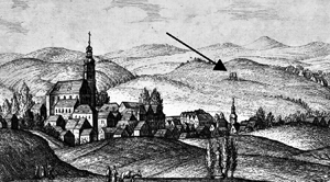
An execution site in Chełmsko Śląskie: A) panorama by Karl Friedrich Stuckart (1819) (public domain: https://bibliotekacyfrowa.pl); B) fragment of the eighteenth-century map drawn by Ludwig Wilhelm von Regler showing the three-pronged symbol for the gallows (Staatsbibliothek Berlin, Preußischer Kulturbesitz, sygn. IIIC card N15140, sheet no.63); C) location identified through the transformation of the historical map using GIS software (see basemap); D) location demarcated by the results of geophysical survey (figure by B. Świątkowski).

Execution sites in Głogówek: a fragment of the eighteenth-century map (A) drawn by Ludwig Wilhelm von Regler (Staatsbibliothek Berlin, Preußischer Kulturbesitz, sygn. IIIC card N15140, sheet no. 90) is overlaid on a modern basemap to identify the locations of the execution sites (figure by B. Świątkowski).

Chełmsko Śląskie: results of magnetic survey (left) and excavation (A) identify the location of the gallows (B) (figure by B. Świątkowski).

Głogówek: non-invasive and surface surveys identify an iron staple from a gallows beam (map by Michał Pisz): A &B) the remains of the scaffold, indicated by small fragments of bricks visible on the surface and in the boreholes in the humus layer (figure by B. Świątkowski).

Trenches were laid out in areas with previously identified traces of dismantled or extant foundations of a gallows, or in its immediate neighbourhood. Due to the peculiar nature of execution sites, this study focused on the structure itself, its interior and the surrounding area that was used for the burial of executed individuals. During the research, no burials were discovered.
Conclusion
This study demonstrates the usefulness of historical hand-drawn maps calibrated in GIS software for the reconstruction of cultural landscapes and, more specifically in this project, for the precise indication of sites that are no longer manifest on the modern land surface. Further verification using non-invasive methods requires a comparative approach, as shown by the research in Chełmsko Śląskie, where traces of foundations were registered by magnetometry but were not visible in the earth resistance survey.
Funding statement
This study was supported by the Polish National Science Centre (grant 2016/22/E/HS3/00373).


