


Introduction
The northwest Maghreb stands out as one of the most significant and yet under-researched areas of the Mediterranean and North Africa in terms of its Holocene prehistory, with the potential to reconfigure our understanding of regional social dynamics and interconnections over some nine millennia (Broodbank and Lucarini Reference Broodbank and Lucarini2019). The targeted archaeological investigation of key sites and landscapes offers one promising way to generate initial data and interpretive models, with an emphasis on open sites, in distinction to the traditional focus on caves. It will take time for a fully rounded, diachronic understanding to emerge, but in the interim such investigations can serve to generate working frameworks, as well as to excite wider interest and an engagement with what may prove to be highly distinctive prehistoric social trajectories, from both an African and Mediterranean perspective.
The archaeological site of Oued Beht (Khémisset province, Morocco) offers precisely this kind of opportunity, strategically situated as it is within the least-known phase of the region's later prehistory, following the first evidence for domesticated plants and animals of western Mediterranean Neolithic derivation in the sixth–fifth millennia, and prior to the first millennium BC Iron-Age world of Phoenician connections (Lucarini et al. Reference Lucarini, Bokbot and Broodbank2021). Although the site may eventually prove to be exceptional in certain respects (even this is hard to establish for lack of comparanda), its wealth of material and scale of activity offer both the data on which to anchor a first provisional regional prehistory at this crucial chronological juncture, and a provocative comparative challenge to models of contemporary social dynamics elsewhere in the Mediterranean and North Africa. Ever since its initial identification in the 1930s, Oued Beht has hovered on the outermost fringes of archaeological consciousness. The ultimate aim of the Oued Beht Archaeological Project (OBAP), a new British–Italian–Moroccan collaboration, is to thrust it into the mainstream of archaeological knowledge, and thereby advocate the integration of the Maghreb's Holocene prehistory within broader discourses. The means to this end comprise a series of targeted archaeological field investigations and associated analyses, focused on establishing the main attributes and practices associated with this truly remarkable archaeological phenomenon. This report details our findings from the first seasons, which even in preliminary form we judge to be significant enough (after decades of inadequate exposure) to deliver to the archaeological world. It complements with fuller data a more schematic overview published elsewhere (Broodbank et al. Reference Broodbank, Lucarini, Bokbot, Benattia, Bigoulimen, Farr, Garcia-Molsosa, Hachami, Laoutari, Lombardi, Marsilio, Martin, Morales, Radi, Rega and Wilkinson2024).
Oued Beht in its topographical, geological and recent land use contexts
Today, the site of Oued Beht lies in the rolling, cereal-farmed landscapes of the Zemmour plateau (Figures 1a–b), in a semi-arid Mediterranean-type environmental zone, with an average rainfall of ca. 481 mm in the nearest town of Khémisset, largely falling over the winter months but susceptible to marked inter-annual variation (Hilmi et al. Reference Hilmi, Mahamoud, El Agbani and Qninba2022). Below it runs the eponymous river, which flows year-round northward out of the Middle Atlas (whose diverse geology it transports in the form of river cobbles) into the Sebou river, the alluvial Gharb lowlands and ultimately the Atlantic. The site lies at a significant crossing point, with the modern trunk road to Meknes and Fez carried by a bridge near the southern end of the site, close to the small village of Aït Siberne, while a pedestrian ford 1 km downstream, overlooked by pre-modern cemeteries, hints at a natural approach from the northeast. Although the site today is roughly 80 km from the sea as the crow flies, maritime access may once (the precise chronology remains unknown) have entailed as little as a couple of days’ travel downstream on foot or by boat (some 30–40 km) if, as is likely, the Gharb's alluvium (which today holds a third of Morocco's surface water, thanks to the Sebou, Morocco's largest river, and its tributaries; Hilmi et al. Reference Hilmi, Mahamoud, El Agbani and Qninba2022) covers a prehistoric estuarine embayment and wetland, comparable to those documented in southern Iberia (for the Guadalquivir, Ménanteau and Vanney Reference Ménanteau, Vanney and Rubiales2011). The site occupies a sub-horizontal southward sloping plateau atop an interfluvial ridge, roughly north–south aligned, half a square kilometre in extent, and with a maximum altitude of 211 m above sea level (Figure 2). This ridge is broad in the north but tapers and gently drops to a slender spine in the south, below the westward-tilted tip of which is located the cave of Ifri n'Amr o'Moussa (henceforth IAM), with deep archaeological deposits. To the east, the perimeter of the ridge is defined by steep slopes, some terminating in sheer drops down towards the river. The other flanks are delineated by smaller incised fluvial channels, with gentler slopes save in the south, where the terminal spine is flanked by cliffs on all sides. A broad upland saddle to the northwest provides the easiest axis of entry and connects the ridge to an expanse of cultivated upland, itself a residual landmass within a wider network of fluvial downcutting (Figure 3).
a. Location of Oued Beht, Zemmour plateau, Morocco: a. regional topographic relief map with Oued Beht and other sites mentioned in the text (GC=Ghar Cahal, NaK=Nador Klalcha, KBa=Kef el Baroud, KK=Kach Kouch, Ce=Ceuta, MM=Maaden el Melh, FA=Fuente Álamo, Arg=El Argar, Ga=Gatas, EO=El Oficio, Me=Mas de Menente, KTG=Kef Taht el Ghar, Oud=Ifri Oudadane); b. Oblique drone photograph of the site and eponymous river from north–east direction, November 2021 (map and photograph: TW).

Drone-derived orthophoto of Oued Beht with hillshading from photogrammetrically derived digital elevation model; marked are MF=Maison Forestière and IAM=cave of Ifri n'Amr o'Moussa (processing: AGM and TW).

Topographic sections along different profile lines of the Oued Beht ridge derived from the drone-generated digital elevation model, A=central ridge line, B=across the northern section, C=middle section down to river, D=across the walled enclosure down to river, E=across the ridge where the IAM cave entrance is (diagram: TW).

Geological and geomorphological exposures are found on the fringes of the ridge and escarpments of the river valley, as well as in areas of quarrying and slope collapse along the edge of an adjacent interfluve to the north. Pending more detailed investigation, some preliminary observations can be made. The geological sequence starts with a bedded, jointed and heavily folded limestone of probably lower Jurassic age; such tectonics are liable to be central to the processes that created the interfluve. This limestone outcrops extensively in exposures throughout the area, particularly in the south. The sub-horizontal summit and sloping edges of the northern part of the ridge are linked to the dip-slope structure of the limestone, with the change in topography towards the northern limits caused by a sharp contact between the limestone and probably Miocene silty or sandy marls beyond, which have completely lost their morphologies due to the impact of agricultural activities. On the eastern flank, badlands have formed on steep marly cliffs that are themselves cut above, through an unconformity, by conglomerates of varying thickness. Several conglomerate deposits have been identified at different heights, characterised by matrix-supported, heterometric and polygenic rounded clasts. These are particularly visible on the surface in the central part of the ridge – and are a source, as will be seen, of raw materials for local chipped and ground stone production. They form terraced morphologies along the valleys and could be related to a continental, fluvial origin linked to Plio-Quaternary sea-level changes and consequent shifts in the base level of the river. This geological setting has created terraces visible on the surface, which are clearly not cultural. The overall topography renders the edges of the ridge susceptible to rain-induced erosion, as witnessed at the base of the slope by fallen angular limestone blocks weathered from bedrock and exposures in the small western ravine of colluvium overlain by homogeneous silt, interspersed with lenses of terrestrial molluscs that document a history of significant erosion interspersed with periods of relative landscape stability – all at present of unknown age. Soils are thin and patchy in the south, directly over the exposed limestone, more substantial but pebbly from eroding conglomerates in the centre and peripheral areas of the north, while the northern core of the ridge is blanketed by soils of variable, and in some areas demonstrably considerable, depth. Understanding these soils and their mode of formation requires further research.
Oued Beht has lain within the jurisdiction of Morocco's Forestry Department and its French colonial predecessor for about a century, as monumentalised by the erection in 1932 of a semi-fortified Maison Forestière on the summit. Around this are smaller structures now in a ruinous condition, whose dating relative to the Maison is unknown. In the centre of the plateau, two rectangular structures aligned NE–SW have existed since at least the 1970s (possibly far longer) and survive in a ruined or unfinished condition, as rubble and earth ridges. Over the last few decades, several farmsteads have been established on the margins of the site but, apart from the extensive fields at the northern end, the only agricultural uses of the ridge itself today are for grazing small herds of sheep, a few formerly cultivated trees and bee-keeping. The ridge has been planted with pines since late colonial times, some now-mature trees, but mostly, following recent fires, replanted saplings. The latter initiative has prompted, from the winter of 2013–2014 onwards, the unfortunate digging of hundreds of closely spaced, shallow planting pits (on average 1 m in diameter and 0.30–0.50 m deep) across much of the north. A combination of aerial and satellite imagery from the 1970s onwards allows this overall recent history to be traced (Figure 4). Pre-20th-century-AD land-use remains frustratingly unknown at present, with probable long periods of nomadic activity, and preliminary indications from OBAP's fieldwork suggest an extraordinarily light impact on the prehistoric archaeology, at least in the north. Water for local residents is currently supplied by drilling, but prior to this is assumed to have derived from the river, in both cases supplemented by rainfall.
Sequence of historical aerial/satellite images from Oued Beht showing changing land use and tree cover over the last 50 years (source: 1974=USGS Hexagon image; 2009–2022=Google Earth Pro historical imagery).

Archaeology at Oued Beht from the 1930s to the present
The construction of the Maison Forestière on the northern part of the ridge appears to have triggered the first recognition of Oued Beht's archaeology. Ruhlmann's brief report of 1936 stresses the abundance, though with little information as to spatial distribution, of polished axes/adzes (this generic term will be used except in cases where examination of the tool allowed one or other usage to be identified) and ground stone tools (henceforth referred to as ‘macrolithic tools’ or ‘macrolithics’). He sketchily identified a véritable village néolithique on the northern part of the ridge, and devoted most of his attention to two long wall/rampart alignments visible in the south that in his view outlined, together with the eastern cliffs, a prehistoric éperon barrée, or fortified enclosure (a relative emphasis to be partly revised in the light of OBAP's findings reported here). Immediately south and below the latter, Ruhlmann also noted the IAM cave. Among subsequent visitors, the most significant in terms of documenting conditions at the site was Souville, during the 1960s (Souville Reference Souville1973, 150–60; Reference Souville1991). From the 1930s, with the tacit consent of the French authorities, to this day, several thousand stone tools are thought to have been removed from Oued Beht by archaeologists, antiquarians, casual visitors and locals. Early collections now housed in the Musée de l'Histoire et des Civilisations in Rabat, and currently studied by MR, contain at least 1341 polished stone axes/adzes alone (the original total may be higher, as indicated by accession numbers; Souville [Reference Souville1973, 159–60] cites 934 items known to him), but many more have irretrievably dispersed abroad into diverse hands. A collection of several hundred stone tools, some 47 axes/adzes and a few pottery sherds has been formed since the early 2000s in the office of the local authority for nearby Aït Siberne village, from finds brought in by local people or made during tree-planting (the axes/adze finds were recently moved for study to the Institut National des Sciences de l'Archéologie et du Patrimoine [INSAP]). Needless to say, the context of all such pieces is lost beyond recovery, a handicap matched more generally by the absence of detail as to the locations of early and even more recent finds within the site – from the surface, or beneath it, and if the latter in what association?
The recent revival of interest and archaeological initiative began with one of us (YB), in collaboration with a sequence of international projects. For some ten years from 2005–2006 the primary focus was on IAM. This cave possesses a geological sequence going back to the Last Glacial Maximum, with evidence for human activity over much of the Holocene. This comprises: (1) Epipalaeolithic occupation (ca. 8000 BC); (2) Early Neolithic (late-sixth to early-fifth millennia BC) levels with burials, yielding a radiocarbon dated seed of domesticated barley, followed; via (3) an unclear interstitial phase, contemporary (as we shall see) with the major activity on the open ridge; by (4) upper levels with Beaker-type pottery and copper Palmela points (mid-to-late third millennium BC); and finally (5) later historical period usage (Ben-Ncer et al. Reference Ben-Ncer, Bokbot, Amani, Ouachi, Sahnouni, Semaw and Garaizar2017; Bokbot and Ben-Ncer Reference Bokbot, Ben-Nçer, Baioni, Leonini, Lo Vetro, Martini, Poggiani Keller and Sarti2008; Martínez Sánchez et al. Reference Martínez Sánchez, Vera-Rodríguez, Pérez-Jordà, Peña-Chocarro and Bokbot2018b, 491).
From 2013, through the efforts of the French-Moroccan Complexe Archéologique de Oued Beht (CAOB) project, attention began to shift to the open site of Oued Beht, at first involving small trenches to document and (with mixed success) date the major walls and built alignments already identified in the south, but then moving north to the vicinity of the Maison Forestière and the area reportedly richest in axes/adzes and other finds. In 2016 a small excavation there explored prehistoric activity surfaces at shallow depth (30–50 cm), including a ‘fond de cabane', and encountered the first ‘silos’, deep, bellying, often narrow-mouthed and crudely bell-shaped pits that have since been confirmed as a key feature of the site (henceforth ‘silo-form pits’, given that a functional association with storage, however plausible in terms of their morphology, remains for now unproven). This exploration was dramatically extended in 2017 by the excavation, assisted by mechanical digger, of nearly a dozen further trenches, each of up to 25 m in length, spread across the northern half of the ridge, to a maximum depth of 2 m. These trenches encountered very large amounts of pottery, notably including a pattern-painted tradition hitherto unknown in the Maghreb, save for a few sherds from Ghar Cahal, 225 km to the north (Becerra et al. Reference Becerra, Vijande-Vila, Ramos-Muñoz, El Idrissi, Gómez-Sánchez, Zouak, Fernández-Sánchez, Bernal-Casasola, Ramos Muñoz, Alaoui, Tarradell-Font and Zouak2021), and paralleled by occasional finds in Iberia (Carrasco Rus et al. Reference Rus and Pachón Romero2012; Mederos Martin et al. Reference Mederos Martín, Schuhmacher, Vargas Jiménez, Bashore Acero, Garvin Arcos and Brandherm2023). Macrolithics, polished axes/adzes, chipped stone, animal bone and small amounts of other classes of material were also reportedly retrieved. Equally striking were the number, size and density of the subterranean pits. Two radiocarbon dates obtained from these have since indicated a date of ca. 3350–2900 BC (Lucarini et al. Reference Lucarini, Bokbot and Broodbank2021, 153; see also below). Such finds and dates, the absence of earlier material in these contexts, the Iberian parallels and lack of metal artefacts argue for the discovery of a major site of a hitherto unknown Maghrebian society, provisionally best characterised as Final Neolithic (henceforth FN; for earlier Neolithic terminology and chronology, Linstädter Reference Linstädter, Reindel, Bartl, Lüth and Benecke2016; Martínez Sánchez et al. Reference Martínez Sánchez, Vera-Rodríguez, Peña-Chocarro, Bokbot, Pérez-Jordà and Pardo-Gordó2018a).
After 2017 this French–Moroccan collaboration ceased and its findings remain unpublished (the field information above derives from the project's annual ‘grey literature’ reports augmented by the first-hand recollections by one of us [YB]). OBAP's current elective remit does not extend to study of the material from these investigations, although its macrolithic and polished axes/adze assemblages and its animal bone are included within the ongoing doctoral studies of Moroccan members of OBAP (MR and HH respectively). However, in light of the risk of permanent information loss, given the absence of accessible documentation and the backfilling of the 2017 excavations, a precautionary effort has been made to determine the location of trenches from this phase of research, and to assess the amount of material from them. Figure 5 shows our present understanding of the location of the French–Moroccan trenches (henceforth referred to in the text by numbered Tranchées, or in abbreviated form prefixed with F or R, to avoid confusion), reconstructed and GPS-ed from a combination of residual surface visibility, on-site memory of team members present at the time and other clues. This knowledge has proved a useful entry point for OBAP's own first sub-surface investigations. In tandem, HB counted the material from ca. 164 finds bags and other containers, almost all from the 2017 season and most with their contexts still identifiable. In total, 8256 items have thereby been quantified, the vast majority from Tranchées 9, 11 (the latter initially referred to as 1) and 14 (occasionally referred to as 15) and especially the fills of some eight silo-form pits within these (this figure and those that follow are likely to be underestimates given the likelihood of further finds bags being identified). This total breaks down into 5878 fragments of pottery, 343 of chipped stone, up to 96 macrolithics (20 definite upper and lower grinding stones, others to be confirmed or rejected by future study), 22 definite polished axes/adzes (plus 16 further unidentified polished stone fragments), 63 pieces of constructional daub, together with 1637 animal bone fragments, 199 bivalve mollusc shells, plus a few bone tools and two shards of ostrich eggshell. Given the ongoing doctoral study of two of these bodies of material, and the unfortunate lack of surviving recorded contexts for many of the lithics from this fieldwork, the most significant untapped gains to be derived from future study should lie with the pottery sample and, of course, the stratigraphy.
High-resolution topographic plan of core site showing the location of trenches undertaken by the French–Moroccan project in 2013–2017 (=CAOB, dark blue, F and R indicate Tranchée number) and current Oued Beht Archaeological Project, 2021–2022 (=OBAP, dark red, T indicates trench number). Surface visible architecture including the major walls (A–D) and locations of less well-preserved structures are indicated (S). MF indicates the Maison Forestière (map: TW).

Intriguing as such previous insights undoubtedly are, they raise as many questions as they answer. Accordingly, OBAP's initial strategy has been to obtain crucial information about several fundamental unknowns, namely: (1) the precise distribution and chronology of the archaeological remains across the site, and especially the extent of the FN concentration on the northern part of the ridge; (2) the nature and structure of the subsurface archaeology, along with geoarchaeological insight into soils and formation processes; (3) a quantifiable sample of material culture sufficient to sustain robust morphological, functional and raw materials analysis; and (4) insight into the basics of productive economy, food-ways and processing of foodstuffs. A short scoping field season took place during 1–7 November 2021, and then a full season during 9–22 October 2022, followed by several days of final recording. Study seasons took place during 1–15 June and 1–13 September 2023. In terms of fieldwork and other research designed to address the above priorities, we began with ground reconnaissance and a UAV (drone)-mounted photogrammetric survey in 2021, followed in 2022 by an intensive pedestrian surface survey over the entire site to address (1) and (3). Geophysics, again over much of the site, was deployed in 2022 to shed further light on (1) and assist in (2). Small-scale excavation in 2021 and more fully in 2022, including soil sampling and two micromorphological columns, targeted (2), (3) and (4), so far exclusively on the northern half of the ridge. In addition, initial geoarchaeological exploration of the site and its environs was undertaken in 2022 to clarify the local geology, geomorphology and recent land use (see above). Analyses of the material culture and environmental samples have been ongoing since 2022, addressing elements of (2), (3) and (4), together with a rolling programme of radiocarbon dating. These operations are reported in detail below, with the exception of the geophysics and geoarchaeology, which will be covered in a subsequent publication together with further results in both realms during and after the 2023 field season. Finally, although studies of the material from the IAM cave are ongoing by members of the current OBAP team, the remit and primary mission of OBAP is the investigation of the archaeology on and surrounding the open ridge, which is henceforth simply referred to as ‘Oued Beht’.
Photogrammetry (2021)
In 2021 a detailed photogrammetric map of the Oued Beht ridge by UAV was undertaken using equipment from the Institut Catala d'Arqueologia Classicà (ICAC), Tarragona. Multiple flight missions were made over the site with two drones, a Mavic 2 Enterprise Advanced and an Autel Evo, at a variety of flight altitudes (mostly between 60 m and 90 m). In addition, ground control points were placed using differential GPS, so as to be able to maximise the precision of georeferencing. The captured images were processed using AgiSoft Metashape, a structure-from-motion-based photogrammetric software, to produce a georeferenced orthophoto with a resolution of approximately 10 cm/pixel, and an initial digital surface model (DSM) of 5 cm/pixel. The DSM was then further processed, filtering out some vegetation and smoothing small artefacts, to provide two working digital elevation models (DEMs) of 6 cm/pixel and 1 m pixel resolution, for hillshading, elevation and contour visualisation. The result has proven an invaluable resource for subsequent mapping and analysis (see Figure 2).
Intensive survey of the Oued Beht ridge (2022)
The aim of the intensive pedestrian surface survey was to establish reliably for the first time the extent of the surface distribution of material and other features over Oued Beht, and to explore the possibility of differential chronological or functional patterning across the site. Taking into account the area of walkable land on the ridge (mainly limited by dangerously steep terrain to east, south and southwest) and the person-power and time available, the decision was made to walk the ridge in 0.5-ha tracts 50 m wide and 100 m in length (except where topographically truncated), deploying an experienced team of five walkers spaced 10 m apart, plus one or two personnel to support by laying out tracts by GPS, transporting finds, etc.. Each walker counted and collected along each linear 10 m segment unit within the tract all the material seen up to 1 m either side of their walker line. This comprised pottery, chipped stone, macrolithics and polished stone axes/adzes; on individual walkers’ initiative, a few other finds came in irregularly, mainly pieces of weathered animal bone. The density of finds, especially over the core of the site, slowed tract-walking considerably while generating a satisfactorily substantial, spatially fine-grained artefactual vacuum sample of 20% of the overall surface investigated.
Altogether, the team walked 56 tracts over five and a half 11-hour days, covering an area of 19.49 ha (Figure 6; the series runs from Tract 101). Initially, the newly fenced-off grounds of the Maison Forestière, comprising ca. 1 ha over the highest point of the ridge, could not be entered, but luckily access proved possible on the final field day, revealing a landscape comparable to adjacent areas outside the fence, save for the graded gravel area around the house itself, and contributing useful information about the northern edge of the site. While full 0.5-ha tracts were the norm across the central zone, other tracts were truncated by steep slopes and cliffs around the perimeter of the ridge or fenced-off areas (as above, plus enclosed farmyards to the west and far north). Surface visibility was generally good, the only impediment being patches of pine needles in areas of mature tree growth – although the open spacing of the older trees (particularly in the western-central area) meant that these issues tended to be segment-specific, with compensatingly better visibility for nearby collection units along the same or adjacent walker lines. Undoubtedly the most significant variation in surface conditions was the presence, absence and freshness of the hundreds of small tree-planting pits dug over much of the northern half of the site (see Figure 8d). At their maximum density these cover 20–25% of the surface in this area and, even more alarmingly, their depth matches that typical of the archaeological layers encountered, excluding pits, in our trenches (see below). Further study will be required to clarify the extent to which such tree-pits have impacted the quantity and quality of the surface and sub-surface archaeology. It is already evident that they tend to bring up large and/or fresh ceramics and weightier macrolithics (as well as most of the putatively old bone collected). However, they do not seem to overly determine material densities on the surface, because abundant, if more abraded, pottery is regularly encountered in areas that have not been tree-pitted, and the same is true to a lesser extent of macrolithics. In terms of the walkers’ average detection rates, analysis showed similar rates of around one item per metre in most cases (69% of the total number of segments walked), with rates of roughly half this level for the remainder.
Extent of intensive fieldwalking, with tracts numbered; the smaller squares are 10×10 m grids. Counted finds of all types indicated by dots distributed within each square to indicate overall find density. The orientation of the tracts was chosen to adapt best to the orientation of the topography (map: TW).

The counting and collection of material within discrete 10 m segments along walker lines spaced 10 m apart generated in total 1961 individual spatial data units, 1850 of which contained archaeological material. A total of 19,626 artefacts was collected, comprising 16,258 pieces of pottery (82.8%), 2947 of chipped stone (15.0%), 371 (1.9%) macrolithics and 50 (0.3%) polished axes/adzes. Subsequent study seasons characterised and chronologically assigned (albeit with variable precision) each item within this sample; in summary, at least half of the total pottery could be assigned a prehistoric date, while most other categories of material are entirely or predominantly prehistoric (see this section for overall patterning, and further below for quantification and attributes as material culture). An additional 135 pieces of bone and shell from walker lines were brought in, as were nine further fragments of polished axes/adzes and macrolithics found off the walker lines but deemed worthy of recovery on grounds of preservation or form, their locations being recorded as spot finds by GPS.
This sample enables detailed spatial analysis of the distribution and limits of surface material across the Oued Beht ridge. Figures 7 and 8 display the patterning for ceramics, macrolithics, chipped and ground stone, with further details for each. Visible striations in densities reflect the greater ability of certain walkers with prior expertise to identify, in particular, chipped stone and the less readily recognised macrolithic types, such as cobble-like pounders – a factor that switches in walker placement later sought to counter, once this issue was realised.
Distribution of finds recovered from surface survey by category: a. dots indicating total weight of all prehistoric pottery fabric types (Fabrics 1 to 7); b. locations of individual diagnostic pottery fragments according to probable date, including painted wares; c. dots indicating total weight of post-prehistoric pottery fabric type (Fabric 8); d. locations of individual macrolithics used as grinding tools, and multipurpose macrolithics showing a combination of grinding and anvil use; e. locations of individual macrolithics of other types (abraders, polishers, burnishers, hammers, pounders, etc.), and macrolithics used for multiple functions other than grinding and anvil; f. locations of individual rotary querns (map: TW).

Distribution of finds recovered from surface survey: a. polished axes/adzes and chipped-stone objects interpreted as products/waste from axe/adze manufacture; b. location of individual chipped-stone artefacts, including sickle elements, circular or arched-front endscrapers, or others. Plus, locations for: c. confirmed ancient pits from excavation; and d. modern tree pits as excavated by forestry department and modern buildings (map: TW).

As Figures 7 and 8 show, the surface survey defined two principal areas of abundant material. In what can now be termed the Northern Sector, the archaeological phenomenon for which Oued Beht has long been known is revealed as a dense distribution of pottery, macrolithics and chipped stone over an area of ca. 9–10 ha across the broadest and highest parts of the ridge. Convincing edges to this distribution can be established on most flanks, notably to the north and west; along parts of the eastern flank there is an abrupt end at the cliff-line, which is likely to have retreated over the last 5000 years, while to the southwest erosional spills downslope into the ravine blur the picture (the southernmost of these does appear to be separated from the main distribution, given decent visibility and low counts across the intervening area). Only to the south, along the ridgeline, is the edge of this distribution significantly fuzzy, although still with a marked drop-off in densities over the ca. 150 m that separate the Northern Sector from concentrations to the south (furthermore, the pottery in this intervening area is mainly post-prehistoric, while much of the chipped stone seems to be expediently knapped from the conglomerates that outcrop here, and some macrolithics may have been locally moved for subsequent wall-building). Within the Northern Sector, a slight drop in densities, notably of pottery, in a diagonal swathe running SE–NW across the centre of the area, might be explained by the erosional effects of a shallow swale heading towards the steeper contours on the western edge of the site.
Several further observations can be made concerning this Northern Sector. Although historical period and modern ceramics, plus a few rotary querns, are patchily encountered across much of the area (especially, though not exclusively, around recent structures), the distribution of the confirmed prehistoric pottery is notably substantial and broadly matches those for prehistoric macrolithics and chipped stone. Moreover, the majority is comparable in form, fabric and surface treatment (including painted pieces) to the pottery from well-defined and dated excavated deposits in the north and can be confidently attributed to the FN. Interestingly, a very few potentially earlier pieces and a more substantial number of possible post-FN prehistoric sherds have also been identified, along with several post-FN prehistoric chipped-stone tools on the southwest side of the Northern Sector. In terms of areas with promising sub-surface preservation, one newly identified prospect constitutes precisely this southwestern side of the Northern Sector, which is less afflicted by tree-pits but otherwise similar in its surface archaeological signature; trial excavation should be a priority here. One final feature on the northwestern edge of the tract-walked area is a small FN concentration spatially distinct from the main distribution, and partly caught by Tract 124 in the midst of a ploughed field with perfect visibility. Field revisitation established that this extends at least 10–20 m beyond the tract-walked area, and so will require further future documentation.
Turning to the Southern Sector (as now defined), this comprises the narrowing spine of exposed limestone and mainly shallow soils, increasingly cliff-girt and tilted westward as it approaches the IAM cave. Here the concentrations of material are smaller, patchier and more obviously varied in date. The largest concentration, though still only of 0.5–0.7 ha, lies between and immediately south of the two major linear structures running across the ridge. It comprises mainly post-prehistoric pottery and several rotary querns, but also an insistent signature of FN and possibly later prehistoric ceramics, as well as substantial prehistoric macrolithics (albeit some possibly re-used in wall construction), and a chipped-stone sample that includes a few definite post-FN pieces, found both here and even further south. Smaller hotspots, several of post-prehistoric date, relate variously to the spillage of pottery off the ridge, down the cliff into Tract 149 from an eroding deposit above; the talus and excavation dump of IAM; and, in the extreme south, a complex of scrappily preserved rectilinear walls accompanied by relatively recent pottery.
One last element of the surface signature of Oued Beht that requires mention is the traces of structures, primarily built features but also subtractive rock-cuttings. These are visible only in the southern part of the ridge, where shallower soil conditions predominate and the bedrock outcrops extensively. The most prominent features are four long lines of walling of a width (over 1 metre in all cases) that precludes explanation as animal folds or domestic architecture, and most oriented roughly east–west, transverse to the ridge (see Figures 5 and 8c). OBAP designates these as Walls A–D. Wall B1 runs across the narrowing ridge for ca. 80 m, atop a major sloping accumulation of earth interpreted by Ruhlmann (Reference Ruhlmann1936, 44–48) and Souville (Reference Souville1973, 152) as a rampart, with traces of a parallel ditch beyond its northern face. It turns at its westernmost point to run south for ca. 60 m as Wall B2 towards Wall C, which also reveals a more modest earthen element, extending ca. 75 m across the ridge. These features, together with the eastern cliff-line, delineate an area of 0.6 ha, or 2.0 ha if extended south to encompass the cliff-girt southern remainder of the ridge – the so-called prehistoric éperon barrée of earlier literature. Walls B1 and C have still visibly been excavated by the French–Moroccan team, with reports of post-prehistoric dates for their final phases, but no definite conclusions as to their origins, which could be earlier, given the prehistoric material around them. No work was undertaken by OBAP on these two walls in 2021 or 2022.
Walls A and D were formally defined in 2022. A small part of Wall A had clearly been trial excavated towards its northern and southern faces in 2017 by Tranchée 14/15. Its fuller line was recognised by photogrammetry in 2021 and explored on the ground in 2022. Best, if still poorly, preserved in its curvilinear northern section, it may continue southwards via conglomerate scarps to define an irregular sub-triangular circuit enclosing a low eminence between the Northern and Southern Sectors. As revealed by the re-opening in 2021 of part of the 2017 trench (OBAP Trench 101; see below), Wall A is very shallow, comprising a single surviving course of stones, and it overlies a deep pit containing prehistoric material (see below). Unfortunately, efforts to radiocarbon date a bone stratified in Trench 101 between Wall A and the underlying pit proved unsuccessful. Overall, however, there is no doubt that this wall is of relatively late date. Wall D was identified in 2022, when it was realised that gaps in the cliff-line at the southern tip of the ridge had been closed off with lines of stone blocks. No date can presently be suggested, though its masonry construction is similar to that of Wall B1. As noted above, between them Walls B1–2 and D would enclose (and, with the cliff-lines, potentially defend) an area of ca. 2.0 ha, including within it Wall C, albeit with no certainty as to contemporaneity or function. Intriguingly, it is precisely this enclosed zone that also contains traces of shorter and thinner stone wall footings and rock cuttings, built or carved from the bedrock and delineating rectilinear structures of unknown date, probably with lost superstructures in mud, daub or other impermanent materials. These, and several more convincingly late built structures to the south and downslope of Wall A, have not been fully studied, and in some cases their irregularities of line and shape resist ready interpretation. Obvious features have been GPS-ed and are shown in Figure 5.
Excavation (2021 and 2022)
The first objectives of OBAP's excavations were to start to characterise the deposit and soil sequence at Oued Beht, and to excavate, record and sample (by flotation) one of the deep pit features that are manifestly a major element of the sub-surface archaeology, yet so far without proper understanding of their creation, purpose(s), contents and filling. In so doing, OBAP was acutely aware that it operated within an environment in which some 15 trenches had already been excavated to varying degrees between 2013 and 2017, offering potential windows into the site's stratigraphy (Figure 5 for all trench locations). From the 2021 and 2022 excavations, all visible cultural and environmental material was retained for further study and analysis, save in two cases of removal en masse of large volumes of backfill, when every effort was still made, but retention certainly biased towards larger pieces. Further cultural material was recovered from the heavy residues after flotation.
Trench 101 (north-west corner UTM 30N 783542,3753561, 205 m asl)
As an exploratory exercise during the brief 2021 season, the southern part of Tranchée 14, excavated in 2017 on both sides of Wall A, was reopened as OBAP's Trench 101 (labelled 2021/T101 on Figure 5). Because this happened before full protocols for OBAP trenches were established in 2022, the naming of contexts/features/samples differs slightly for Trench 101, though the substantive results are fully comparable. Hereon, OBAP-wide unique Feature numbers will be indicated at first mention using the [F.nn] notation; Sample numbers are similarly unique across the project; Context numbering will be local to the trench being discussed. Trench 101 is located near the centre of the ridge, on the margins of the Northern Sector and adjacent to the southern face of Wall A. It aimed to explore the stratigraphic sequence in this area, the chronology of Wall A and its relationship to prehistoric activity in this area – notably because a deep pit was known to exist beneath it. Excavation lasted four days from 1 November 2021 and extended 1.8 x 1.4 m in area and 1.72 m in depth (Figure 9). The 2017 backfill was removed as a single Context 0, containing prehistoric pottery, most of standard FN types but a few of potentially slightly later prehistoric date (see below), as well as post-prehistoric sherds (unretained, exceptionally for OBAP protocols as subsequently defined) and animal bone. The section was then cleaned and a small, hitherto overlooked, basal feature excavated. Altogether 12 contexts were identified in section (Table 1). The deepest stratigraphic layer, Context 11, consists of conglomerate bedrock, on top of which has formed a reddish natural layer with abundant clay and small pebbles (Context 10); no archaeological material was identified in section. Both Contexts 11 and 10 were cut by the main pit, named Pit 9 [F.9], which was itself cut by Feature 1 [F.1], a small, shallow pit at its base – Context 8 for the cut, Context 7 for its fill. Feature 1 had apparently not been detected during the 2017 fieldwork, and was filled by a dark brownish layer with several stones. Above it, Pit 9 was filled by at least two Contexts, 6 and 5, which contained abundant materials visible in section, mostly faunal remains and ceramics. Both Pit 9, which seems to have been truncated, and the geological layer were covered by a yellowish layer also containing artefacts and animal bone in section (Context 4). On top of this, a brownish layer (Context 3), up to 70 cm deep, contained animal bones in the north section, one of which was selected for (unsuccessful) radiocarbon dating. This layer, which seems to be of natural origin and formed over a long period of time, lies at the base of Wall A (Context 2), which was built on top of it. Wall A is therefore late in the sequence; its remains comprise a single course of stones, presumably the bedding layer. Covering all this was a thin surface Context 1. Five samples, namely the bone fragment mentioned above from Context 3, and four charcoal samples from Contexts 5, 6, and 7, were collected from the north section. Among these, Samples 1, 2, 4, 5 were selected for radiocarbon analysis (locations shown in the north section at the bottom of Figure 9). The results are reported below, and confirm FN fills in the pit, but there was too little collagen in the bone to allow dating of Context 3, immediately underlying Wall A.
Trench 101, plan and sections; north section with source location of collected samples for 14C (drawings: HB and ABr).

Trench 101; depths, context, sediment descriptions and interpretation.

Trench 1 (north corner UTM 30N 228673 3753532, 211 m asl)
In 2022, OBAP's Trench 1 (labelled 2022/T1 on Figure 5) partially reinvestigated Tranchée 11 (labelled F11 on Figure 5; also referred to in some records as Tranchée 1), a long slot about 1 m wide that had been initially machine-excavated on a NW–SE alignment in 2017, 25+ m south of the Maison Forestière (Figures 10a and 10b). It was understood that the trench contained unexcavated archaeological features (presumed pits), and the naturally accumulated sediment or soil sequence was considered likely to be only minimally affected by modern disturbance. The stratigraphic sequence was also thought to exhibit good time-depth due to the trench's position near the flat summit of the ridge and the absence of obvious erosional slope processes or other forms of truncation. Excavations in Trench 1 began with the removal, as Context 101, of a 3 m stretch of backfill from previous excavations. After an assessment of the stratigraphic sections, it was decided to extend the trench northeast into previously unexcavated areas, by manually excavating two 1 m wide slots, Trenches 1.2 and 1.3. The aims were to: (1) assess the level of modern disturbance to the stratigraphic sequence; (2) identify when cut features could first be seen in plan during controlled excavation; (3) evaluate the level of stratigraphic complexity in the sequence; (4) characterise the nature, timing and duration of the deposit sequence in plan and section; and (5) assess the impact of soil erosion and tree planting on the archaeology.
Trench 1, plan and sections (drawings: ABi, LF, and ABr).

Trench 1, photo and sections (photo: LF; drawings: ABi, LF, and ABr).

Excavation revealed a series of five stratigraphic units (Table 2). The uppermost (Context 102) was a compact, mid-greyish brown sandy silt, with a very abrupt and clean lower contact. During excavation this unit fell apart in laminar plates and came away cleanly from the underlying unit (103). The nature of this context boundary implied stratigraphic truncation, occurring with or without significant depositional hiatus. Modern material was found in this unit (e.g. plastics, aluminium foil and clear glass; a few recent wheel-made sherds were also found, although it is noticeable that even here, as in the 2017 backfill and other contaminated contexts, the pottery is still overwhelmingly prehistoric). Context 103 was paler and firmer than the overlying unit. After the removal of 103, cut features became visible in the top of Context 109. Contexts 103 and 109, at ca. 10–25 cm depth, seem largely undisturbed apart from localised truncation by modern cut features. Apart from a single intrusive wheel-made sherd in 103, they contain entirely prehistoric material, mainly pottery, chipped stone, constructional daub and animal bone. Discrete horizontal horizons expressed as minor differences in soil texture or ephemeral stratigraphic contacts, only detectable by feel, occur throughout, suggesting that the stratigraphic profile has undergone no more than localised modification in recent times. No obvious plough scarring was identified in plan during the excavations.
Trench 1; depths, context, and sediment descriptions.

Two cut features were identified in Trench extension 1.2: the terminal portion of a modern linear feature or elongate pit (Feature 106 [F.106]) and a shallow oval pit (Feature 111 [F.111]) of unknown age. Feature 106 contained pieces of modern debris, and in stratigraphic section is clearly sealed by the uppermost stratigraphic unit in Trench 1 (Context 102), implying that Context 102 must have been deposited in very recent times and may relate to modern landscaping. Feature 111 was the only one of possible archaeological significance observed at this depth in the stratigraphic profile; its fill (Context 110) contained FN and other less finely datable prehistoric pottery; radiocarbon dating of its charcoal would be advantageous.
Contexts 113, 114 and 115 are best characterised by their pale yellowish-brown colour, with orange mottling, which is indicative of high carbonate content and some iron enhancement. They contain similar prehistoric material to Contexts 103 and 109 but with higher counts of pottery and bone, and more often fragments of macrolithics. It is uncertain where in the soil profile this carbonate and iron enhancement is taking place and by what mechanism, though some preliminary observations can be made. Powdery white nodule growths in Context 113 suggest a translocation mechanism, whereby carbonate in solution precipitates out within a subsoil horizon, rather than forming within the soil's upper (A) horizon. The pale, almost white colour of Contexts 114 and 115 implies extremely high carbonate content, and no carbonate nodular forms were observed in this unit, possibly indicating that the fabric of the sediment is already saturated with carbonate precipitation. Terrestrial molluscs at the top of Context 114 may indicate a stabilised surface, suggesting that carbonate enhancement has formed within the upper part of an ancient soil profile, a hypothesis supported by the several archaeological features (primarily pits) cut from this surface. However, numerous questions remain. Were all such features cut from the same place within the calcium carbonate enhanced horizon? What is the parent material of the soil profile? What is the mechanism(s) of carbonate enhancement within the stratigraphic profile? How many carbonate enhanced horizons are there in the full stratigraphic sequence, and how old are they?
To assess the bulk sediment properties of the stratigraphic profile, a sample Soil Column (SC-1A) was cut into the south-facing section of Trench 1.3 and a series of small bulk sediment samples were taken at a resolution of 4 cm or less, respecting context boundaries. Any minor changes observed in sediment texture were used to define boundary divisions between samples. A total of 16 small bulk samples were taken (Table 3) to understand the stratigraphic sequence and its formation. Two micromorphology samples, 518 and 519, were taken from the top and base of the calcic horizon. Bulk sediment samples from SC-1A were tested for soil pH, electrical conductivity (EC), redox (Eh) and element chemistry. The results are typical of a well-resolved, broadly intact semi-arid soil profile, where distinct oscillations in the element concentration data, together with composite soil microstructures seen in the micromorphology, appear to reflect a slowly accreting soil profile with episodes of stabilisation. Three possible stabilisation surfaces, associated with cut features, were identified in the geochemistry results: 1) Context 109 (ca.17–21 cm depth); 2) at the top of Context 113 (24–28 cm depth), and near the top of Context 114 (40–42 cm). A further less well-defined stabilisation surface may exist at the boundary within Context 113 (31–34 cm).
Trench 1.3, sample Soil Column SC-1A; results of bulk sediment analysis. Grey tone indicates possible stabilisation surfaces. Soil pH, Electrical Conductivity (EC), Redox (Eh) were measured using a Hanna pH/EC combo tester and a pH/ORP tester, and Element Chemistry was measured using ICP-OES (studied elements were: Al, Sb, As, Ba, Cd, Cr, Co, Cu, Fe, Pb, Mn, Mo, Ni, P, Se, Sr, Sn, Ti, V, Zn, Ca, Na and Mg). For clarity, only Titanium (Ti) concentrations are shown here. Enhanced Titanium concentrations are paired with depleted or enhanced EC and Redox values, and evidence of cut features to indicate possible stabilisation surfaces.

Trench 2 (southwest corner UTM 30N 228746 3753486, 207 m asl)
Trench 2 (labelled 2022/T2 on Figure 5) developed from the reopening of long, linear Tranchée 9 (labelled F9 on Figure 5), as excavated in 2017 and known to contain an impressive series of previously excavated and intact deep silo-form pits, along with its slightly curving extension northeast (the latter maybe Tranchée 15, although this number also appears to have been used for part of Tranchée 14) (Figure 11). These pits were understood to be large and closely packed and to contain stratified fill sequences providing optimal conditions for investigating the timing, nature and duration of feature in-filling. Tranchée 9 had been located on contour, meaning that signs of downslope drainage from erosional events would be captured in cross section. Work in Trench 2 began with the large-scale operation of removing the backfill from Tranchée 9 and its extension, with associated finds grouped as Context 200. This contained a surprising number of sizeable, almost entirely prehistoric, pottery sherds and animal bones (close to 800 of each), as well as other lithic material (68 chipped and 30 macrolithics), 25 bivalve shells, two lumps of constructional daub and a bone tool, all assumed to derive from the excavation of this trench or in its immediate vicinity. It rapidly became clear that while Tranchée 9 had been deeply excavated to the bottom of four silo-form pits, with each half-preserved in the northern section, its northeast extension had been left at a shallow depth. Thus, a spectacular section could be re-exposed in the former, and fresh archaeology in the latter.
Tranchée 9 (labelled F9) excavated by CAOB in 2017 and re-excavated as Trench 2 by OBAP in 2022; the outlined and drawn part of the trench's north section includes Pit 228 [F.228], known as Silo/SL 92 by CAOB (photo: GL; drawing: MR and ABr).

Assessment of Trench 2's stratigraphic profile revealed an almost identical sequence to that revealed in Trench 1, namely from bottom to top: (1) a well-developed calcic horizon; (2) an iron-enriched unit with soft calcium carbonate nodules; (3) brownish grey, aggregated silt with presumed modern cut features, rooting and possible disturbance by slope erosion; and (4) a thin cap of brown sandy silt similar to Context 102 in Trench 1 and considered to have accumulated very recently. Importantly, older cut features (pits and postholes) were observed to be cut from the top of the unit containing soft carbonate nodules (Context 202A), not the well-developed calcic layer stratigraphically below. This decisively corrects any misapprehension that the latter, calcic, layer constitutes the principal living surface; much of the prehistoric archaeology is actually to be found in the (on average) 30–40 cm overlying it. Context 202A exhibited numerous topographic undulations on its upper contact and it is uncertain whether these relate to the bases of overlying cut features or to erosional episodes. Recent cut features are sometimes located above the location of earlier archaeological pits, though it remains to be established whether this is coincidental, given the density of both prehistoric features and modern tree pits, or a result of deliberate searches for artefacts; on present evidence, the former seems more likely.
One of the key objectives of 2022 was to excavate a previously intact silo-form pit, record and sample its stratigraphic profile, interpret the fill sequence and sample soil for flotation. One such, Pit 222 [F.222], was located against the north-facing section of Tranchée 9's northeast extension, and although this feature had been overcut ca. 10 cm by machining in 2017, a stratigraphic record remained in section of the truncated sediments. In 2022 this feature was 50% excavated, leaving half remaining in section (Figure 12). All material removed from the pit during excavation was wet-sieved. The stratigraphic fill sequence of Pit 222 consisted of numerous distinct depositional units (Figure 12). Fill deposits of similar types were grouped together into depositional facies in order to highlight phases in the infilling process (Table 4). Five facies were identified, and preliminary interpretations can be proposed (Table 5). Sharp stratigraphic boundary contacts were evident throughout and suggest an episodic infilling process of uncertain duration, with no stratigraphic evidence that the pit was deliberately backfilled. Further insight into this episodic natural infilling includes thin (<1 cm), well-developed and defined carbonate lenses in Contexts 201.15–201.9, which could suggest depositional hiatuses between individual infilling events of more than a year in duration, while the similar average sizes of infalling sherds from the bigger samples throughout the sequence, coupled with the homogeneity of cultural material following the earliest deposition (see below), suggest a limited overall timespan of infilling, within a single ceramic phase. Pit 222 contained abundant and exclusively prehistoric cultural material comprising pottery datable entirely to the FN, macrolithics, chipped stone, constructional daub (though notably little compared to Trench 1), animal bone, shell, and, as revealed by wet-sieving, macrobotanical remains (see below). Carbonised organic material, some adhering to two large, fairly fresh sherds from a single vessel, was notable in basal Context 201.16, the initial deposition layer, and taken for further analysis. A series of stratified radiocarbon samples was also obtained, confirming a range of fourth millennium BC dates (see below). Interestingly, a tentative case can be made that the pottery of the basal level represents an early phase of the FN ceramic sequence, matching the observation that this level, and one slightly above it (201.10), have yielded the earliest radiocarbon dates so far obtained from the site.
Trench 2 section showing Pit 222 [F.222], its stratigraphic units with source location of collected samples for 14C (drawing: LF and ABr).

Trench 2. Fill sequence of Pit 222 [F.222] (Contexts 201.02, 201.11 and 210.12 are not part of the main stratigraphic sequence and do not appear in the stratigraphic section).

Trench 2. Summary description of Pit 222 [F.222] fill facies and their interpretations.

Five micromorphology samples were taken from Trench 2. Three address the general stratigraphic sequence and overall site formation factors. One of these, Sample 844, was taken from Section 2.1 at the western extent of the trench, where the 2017 excavations had revealed four large silo-form pits. It came from a spur of natural sedimentation between two of these pits where early soft sediment deposits appeared to exhibit enhanced weathering and may represent the terminal Pleistocene timeframe. Two further samples, 830 and 834, were taken from Context 202A–B and 202C respectively, because several archaeological features, including Pit 222 and a possible posthole (F.204), were observed to be cut from the upper contact of this context. Lastly, two micromorphology samples were taken from distinct fill deposits within Pit 222. The first of these, Sample 837, was taken from Contexts 201.06–201.08 (Facies 3). The aim of this sample was to investigate the eastward orientation of the sediment infilling and the compositional character of the sediment. The second, Sample 841, was retrieved from Contexts 201.01–201.05. (Facies 4–5). The aim here was to understand the formation of the white carbonate-rich silts which occur toward the top of the fill sequence.
Micromorphological analysis of the overall soil sequence in Trench 2 confirmed an almost identical lower stratigraphic sequence to that encountered in Trench 1. Carbonate accumulation and translocation observed in the stratigraphic profile appear to have occurred through a variety of processes including: 1) concentration in the upper soil horizons/ground surface through evaporation and weathering; 2) fixing in the upper soil horizons through biological processes, e.g. root respiration; 3) translocation though the soil profile (i.e. the per descendum model [Gile et al. Reference Gile, Peterson and Grossman1966], evidenced by micritic channel coatings, micrite accumulation in soil pore spaces and carbonate clast coatings); and 4) microbial factors in association with carbonate nodule formation and accumulation. Micromorphology also determined that the infilling sediments of Pit 222 comprise variably mixed, aggregated, predominately fine-grained soils and other materials deriving from human activities (i.e. large pieces of charcoal, fragments of animal bone and possible faecal spherulites from herbivore dung.) Re-worked soil aggregates found in the fill sequence appear to derive from several horizons (iron enhanced horizons, humic horizons and presumably upcast calcic horizons). The presence of all these implies a significant time-depth to soil development prior to pit-cutting. It was also possible to determine that Pit 222 was indeed left open after use and episodically infilled, most likely through natural slumping and erosional processes, for example after periodic heavy rains. This is indicated by the sharp stratigraphic boundary contacts visible microscopically, instances of clay illuviation (clay coatings on channel voids; e.g. in Context 201.06) and signs of repeated wetting and drying (planar voids; e.g. in Context 201.07).
Material culture (2023 study and analysis)
Before presenting a first outline of Oued Beht's material culture, it is instructive to compare the picture derived from each of the several, very different, ways in which information has come to light. Table 6 portrays quantities and percentages for all the main categories of find, including animal bone/shell/ostrich egg, produced by 1) early collections since the 1930s; 2) material handed in over the last 20 years to the local collection in Aït Siberne; 3) the French–Moroccan excavations (almost entirely the 2017 season, in terms of known and documented finds); 4) backfill from the 2017 season exhumed from Tranchée 9 en masse in 2022; 5) OBAP's own excavations in 2022; and 6) the 2022 surface survey.
Quantified representation of different material categories and animal bone/shell/ostrich egg recovered from different phases of intervention at Oued Beht. Some are approximations and others may be subject to minor changes. Note that bone/shell/ostrich egg were not formally collected by the 2022 surface survey due to taphonomic and dating concerns. In order to facilitate comparison between excavation and survey data, the unbracketed percentages therefore relate only to the artefactual categories from each intervention, excluding bone/shell/ostrich egg. The percentages in brackets for bone/shell/ostrich egg are relative to total material counts.

What is immediately obvious is that polished stone axes/adzes, the finds that first put Oued Beht on the map, are either now a chronically depleted resource after a century of informal targeted removal, or most numerous in some kind of sub-surface context that has yet to be archaeologically encountered. The former is more likely, and indeed the absence of any axes/adzes from Pit 222, together with the modest numbers reportedly encountered during the large-scale fieldwork of 2017 (most of the latter unfortunately without context labels, so perhaps in large part [near-]surface finds), could suggest that axes/adzes were typically deposited in contexts at shallow depth, and thus readily found by the builders of the Maison Forestière, as well as generations of local people. The proportionately low showing of such axes/adzes among the finds handed in to the Aït Siberne collection may reflect their market value. Macrolithics have survived on the site more robustly into the present, alongside a major showing in the Aït Siberne material, with probably over a thousand items known from all sources combined. The relatively modest counts from the large-scale 2017 excavations compared with OBAP's small-scale 2022 excavations is unexpected, and may be balanced by discarded finds in the 2017 backfill. Regardless, the 2022 surface survey stands out as the primary source, to date, of a major, spatially contextualised sample of such macrolithics. The chipped-stone results are likewise surprising, with both the 2022 survey and excavation data revealing a greater overall significance than previously realised. Lastly, Oued Beht's prehistoric pottery was scarcely noted in the 20th century, barring a brief reference by Souville (Reference Souville1973, 154-55) to coarse jar sherds, tunnel lugs and raised incised or impressed bands, none illustrated or apparently retrieved. A few tunnel lugs and handles qualified for the Aït Siberne collection, but essentially Oued Beht's pottery major repertoire only came to light in 2016–17, with the 2017 excavations encountering nearly 6000 fragments (more, if 2017 backfill counts are included). To this can now be added another 1379 sherds from new excavations in 2022 (or 1295 excluding those from stratigraphically excavated backfill), plus around 16,258 from the survey, slightly over 60% by weight of the latter of which is prehistoric (the bulk processing of the survey material's fabrics being by weight rather than count, though with counts for feature sherds; see below). Oued Beht can now be affirmed as a massively ceramic prehistoric site. It should be noted that animal bone percentages are only given for excavated contexts, given its poor survival on the surface (hence its exclusion from formal collection during survey); within the subsurface samples, the 2017 and 2022 excavations show broadly comparable levels, though in 2017 with a high level of discard on site, or non-recovery, as suggested by the number of fragments found in the 2017 backfill of Tranchée 9.
Pottery
The pottery recovered by OBAP comprises two very different samples, from excavation and survey. All material in both was processed by count, weight, wall thickness, fabric texture and abrasion, and then divided into macroscopic fabric types (quantified by weight only). All diagnostic feature sherds (defined as rims, bases, handles, lugs, as well as all body sherds bearing substantial burnish, slip, or decoration [painted, impressed, plastic, incised, combed, or, for later material, glazed]) were extracted for more detailed recording.
The core of the excavated pottery sample is 1379 sherds stratigraphically excavated in 2022 from Trenches 1 and 2, comprising 803 sherds from Trench 1 (including a minority from surface cleaning and stratigraphically excavated backfill) and 576 from Trench 2's Pit 222, the latter a remarkable total from the fill of one modestly sized cut feature, half of which remains in section. This can be augmented, in a secondary role, by 79 sherds selected in 2021 from the 2017 backfill excavated by OBAP's Trench 101, one sherd from a possibly undisturbed context at the top of its Context 7, and another 830 collected semi-systematically during the removal en masse in 2022 of the 2017 backfill in Tranchée 9 and its extension to create OBAP's Trench 2. Despite the latters’ loss of stratigraphic context, the wide dispersal of the 2017 trenches ensures that these backfill finds do remain spatially informative as indicators of the pottery in and around them, and more generally useful as a source of appropriately cautious insights; those from Tranchée 9 have been formed into a study collection. In contrast to the mixed date of the survey material (see below), the excavated pottery is overwhelmingly prehistoric in date, barring six wheel-made sherds in the upper stratigraphy of Trench 1 and a few pieces from various backfills (the latter possibly surface material introduced during earth-moving). This seems to suggest that most of the post-prehistoric pottery is relatively recent, and has seldom got deep into the soil.
Study of the prehistoric pottery began with the excavated material (Figure 13). So far, it reveals a high degree of homogeneity across contexts freshly excavated and re-excavated in 2021–2022 across the Northern Sector. This, together with the associated radiocarbon dates (see below), provides some confidence in constructing for the first time a basic FN ceramic assemblage for NW Morocco. As no intact examples of the FN vessel types (or most other prehistoric pottery) used at Oued Beht have been seen in modern times by archaeologists, building up knowledge of the ceramic assemblage depends on an iterative process involving cumulative observations and recursive inferences from sherd material, and in particular on developing a working set of fabrics, surface treatment types and forms, and identifying the correlations between these. Our understanding of the prehistoric pottery of Oued Beht will undoubtedly deepen as the sample grows through further fieldwork and analysis, and this summary will assuredly need to be revisited and revised.
Ceramic assemblage from OBAP 2022 survey collection and excavation: a. main prehistoric fabrics (macroscopic; not in scale); b. diagnostic FN sherds; c. diagnostic FN painted sherds; d. unusual prehistoric sherds (photos: MR, RL and RMMS).

Two principal fabrics provisionally stand out macroscopically, subject to confirmation or modification in future by ceramic petrology (Figure 13a). Fabric 1 makes up about two-thirds (65.5%) of the excavated pottery by weight, and employs a buff clay with a range of dark and light grits, variably levigated to a coarse, medium or occasionally strikingly fine fabric; in reduced versions the colour shifts to grey. One subgroup has a more reddish clay colour and distinctive firing in section, turning purple when reduced, but cannot otherwise be distinguished at present. This presumably local fabric is used for most shapes and is the standard choice for most with elaborated surface treatments, which are common on it. Fabric 3 comprises the majority of the remainder, at a fifth (20%) by weight; it is red-brown, with usually coarse mixed grits, firing dark grey when reduced and typically friable; it occurs in several forms but is used preferentially for large shallow plates; a rarer version (Fabric 4; an additional 6.1% by weight) has notable amounts of organic temper. A few other minor fabrics include Fabric 2 (buff and similar to Fabric 1 but with dominant reddish inclusions), Fabric 5, pale off-white with organic temper, and linked to the constructional daub discussed below, and a collective Fabric 6 used for diverse other rare prehistoric fabrics. Fabric 7 is used for any indeterminate prehistoric fabrics and Fabric 8 is a temporary hold-all for post-prehistoric material.
In terms of shapes (Figure 13b), this is an assemblage of open bowls and closed jars (mainly wide-mouthed but a few with constricted access), in a range of sizes, from some large vessels, to judge by occasional thick-walled (> 1 cm) sherds and a few massive tunnel lugs or broad strap-like handles, through a majority of medium-sized shapes, to a few clearly small and sometimes thin-walled (≤ 0.5 cm) pieces. Rims are mainly quite steeply outsloping, upright or steeply insloping, or less commonly incurving, tend to be plain and rounded, articulated by slight eversion, or very rarely thickened. Bases are uniformly round, so harder to identify and under-represented, though on larger vessels they are recognisably thickened. Most rims belong to apparently fairly deep bowl or jar forms, the majority with a diameter in the >10 cm to ≤30 cm range. One further distinctive shape is the aforementioned shallow plate, with a gently curving rather than strictly flat base, and typically an unfinished lower/exterior surface, as if formed in the ground. To summarise, in terms of shapes there is strong evidence for food preparation, serving and consumption, as well as bulk and small-scale (preciosity?) storage.
Surface treatments are mainly based on red-brown or dark brown firing slips, usually well burnished and occasionally to an impressively lustrous finish (burnished pieces without slip are also common). These slips are preserved on about a quarter of all the prehistoric sherds from Trenches 1 and 2, with dark brown slip noticeably more frequent. The substantial majority occurs on the outer surface of the vessel, whether it be an open or closed shape. Some 50 sherds bearing pattern-painted decoration were also found in these trenches, executed using either of the main slip colours, and in one instance both, in what appears to be a deliberate bichrome effect (Figure 13c). The OBAP examples found so far are generally small or poorly preserved, and comprise multiple thin or broad bands, straight, wavy or rarely cross-hatched, as well as an interior rim band on vessels whose outer wall is uniformly slipped. Both slip and painted decoration are most often applied on moderately or finely levigated versions of Fabric 1. Remarkable as the painted material certainly is in a northwest African context, and with a good case for local production on the basis of its fabric association, its average frequency is only 3.6% of the total pottery excavated to date, although this varies by context and doubles in Pit 222, from where most (ca. 40) of the painted sherds freshly excavated by OBAP derive, with examples being found in varying frequency in all the middle and lower fills. One further distinctive decorative type is largely restricted to cooking plates, and consists of finger-impressed pie-crust patterns around the low rims. There is much micro-variation in this last form of decoration, perhaps hinting at a less specialist production of these forms, in contrast to the high level of technical proficiency seen in most of the remaining pottery.
Two final observations can be made about the excavated FN pottery. The first is that, while the basal material from Pit 222 still contains standard FN forms, some of the sherds have a noticeably softer fabric, possibly suggesting a lower firing temperature, and the ratio of surface treatments is different, with less red-brown slip and burnish, more unslipped but burnished sherds and an idiosyncratic attempt to create a pierced lug, punctured through the interior wall of the vessel, which may indicate descent from the internal lugs of Middle Neolithic pottery (Martínez Sánchez et al. Reference Martínez Sánchez, Vera-Rodríguez, Peña-Chocarro, Bokbot, Pérez-Jordà and Pardo-Gordó2018a). Tentatively, in conjunction with the stratigraphy (see above) and radiocarbon dates (see below), these traits might indicate an early phase in the FN sequence. An equally interesting observation concerning the FN pottery is the number of post-firing holes drilled through the vessel wall apparently with a rotating lithic, and from the outside inward, to leave a conical perforation, mainly on pieces in Fabric 1. Initially these were assumed to be mend holes, but there are no signs of wear from a binder on adjacent slipped surfaces and other explanations (such as suspension?) may need to be entertained.
Among the excavated pottery, three further prehistoric sherds stand out immediately as unusual, whether imports from regions with different traditions, or (see below) more likely of later date (mid-later third, second or even early first millennium BC; Figure 13d). Two come from Trench 101, the first a large jar with red-brown (unburnished?) slip and a horizontal plastic band with sharply vertically incised lines, the second a possibly stratified piece at the top of Context 7, from a large, thick-walled vessel, unslipped but bearing a horizontal row of fingertip/fingernail impressions on its outer surface. Parallels exist for both these decorated bands at Kef el Baroud, where they are attributed a third millennium BC or slightly later date (Mikdad pers. comm). Oddly, the second sherd lies stratigraphically between radiocarbon dates that fall squarely within the FN time-range (see below; how this is to be explained is uncertain, although the multiple interventions and backfilling in this trench may be responsible). It is certainly striking that on this southern margin of the Northern Sector, some plausibly later prehistoric material is in evidence. The final example is even more enigmatic and comes from backfill removed in 2022 from Tranchée 9 and its extension, so in this case fully within the Northern Sector but without context. It is a body sherd bearing distinctive U-shaped plastic decoration with punctuations, a later prehistoric decoration type paralleled at early first to second millennium BC Kach Kouch, early first millennium BC Ceuta and elsewhere in the region around Tangier (Bokbot and Onrubia Pintado Reference Bokbot, Onrubia-Pintado and Trousset1995, 222–25; Villada Paredes et al. Reference Villada Paredes, Torres and Suarez Padilla2010, 251, plate 31; Benattia et al. Reference Benattia, Bokbot, Onrubia-Pintado, Benerradi, Bougariane, Bouhamidi, Carballo-Pérez, Echcherif-Baamrani, Elqably, Ghayati, Hachami, Kbiri-Alaoui, Lazarescu, Lombardi, Lucarini, Martínez-Sánchez, Mateu-Sagés, Menéndez-Molist, Montero-Ruiz, Ouakrim, Pérez-Jorda, Radi, Sobrevia-Corral, Touri and Broodbankin press). As a final note of caution, while the Trench 2 Pit 222 finds can be fairly confidently ascribed exclusively to FN, ongoing refinements in our understanding of fabrics and shapes may reveal slightly later prehistoric elements among the more open contexts in Trench 1.
Turning to the survey sample of 16,258 sherds (or 162 kg), this contains abundant prehistoric material, as well as a substantial amount of later pottery, the former 61.6 % by total weight but a lower 49.6% by feature sherd count. All the survey pottery has undergone initial processing, but only the prehistoric component has been fully studied, including detailed recording of 1259 identified feature sherds. Preliminary evaluation of the post-prehistoric pottery suggests that most belongs to the last few centuries before present (some is more or less contemporary, notably around the current farms) and represents residues of inhabitation, including the Maison Forestière, or other rural activities. A small amount could, however, be earlier second or even first millennium AD in date, and fuller study remains a future priority, to close the gap in our knowledge between prehistory and the present. One observation of practical use when assigning less diagnostic pieces is that while much of the prehistoric pottery from the survey is covered by a concretion indicative of contact with the calcic sub-surface conditions described above, this is never encountered on later pottery. This affirms that much of the prehistoric surface material has been brought up by recent tree-pitting or other processes from buried levels lying close to or within the calcic layer.
Study of the prehistoric survey pottery confirms that the basic typology derived from the trench finds does translate reasonably well to deliver horizontal resolution over almost 20 ha of the Oued Beht ridge. Gratifyingly, the FN fabrics, surface treatments and shapes identified in the trenches proved to be present and quantifiable in strength, with ca. 582 definite FN pieces and many more probable ones, both in areas whose subsurface record has been explored, and those where it has not (including a further 61 painted pieces, albeit most commonly in areas with recent tree-pitting). As seen in Figure 7a, this material makes a crucial contribution to defining the extent of FN activity across the Northern Sector, and also identifies small amounts of such material further south, focused between and around Walls B1–2 and C.
However, unsurprisingly given the wider purview of the survey, some previously less familiar prehistoric pottery was also detected. This included a greyish-brown grittier version of Fabric 1 commonly associated with plain surfaces, coarse fabrics and occasionally unusual morphologies, including more fully evolved handles possibly suggestive of a later prehistoric date (Figures 13a–b). Also present were a few sherds in micaceous fabrics, strongly associated with incised, combed or possibly impressed surfaces; most may well be post-prehistoric, but a few abraded body sherds look more persuasively prehistoric and have been assigned to collective Fabric 6. Overall, some of this variability may be attributable to functional variation in activities across the ridge, yet there seems little doubt that it also reflects a wider chronological timespan than seen so far in the trench material. One micaceous Fabric 6 rim sherd in particular, from Tract 102 at the centre of the Northern Sector, with two horizontal rows of short, diagonally slashed shallow incisions, is likely to be earlier Neolithic, perhaps indicating an area of occupation broadly contemporary with the burials in IAM. More numerically significant are the ca. 168–184 feature sherds whose fabrics (including the version of Fabric 1 just described), shapes or occasionally decoration types appear to point to a later prehistoric date than can be recognised so far in the securely stratified trench material. Perhaps these belong to an evolved FN or undefined Maghrebian phase contemporary with the third- to mid-second millennium BC Copper and Early Bronze Ages of the western Mediterranean. Proof of this will require better stratified examples than the trenches yet furnish and more distinctive diagnostics, as the sample size grows. For the moment, it can be noted that while such finds are sporadic across much of the ridge, they may concentrate slightly on the western side of the Northern Sector and, relative to the standard FN material, are more frequent in the Southern Sector around Walls B1–2 and C.
Lithics (i) chipped stone
Some 3368 pieces of chipped stone were collected by OBAP in 2021–2022 (Figure 14). The great majority (2947) come from the surface survey, with 421 from excavations in Trench 1 (63 pieces) and Trench 2 (358 pieces, most found in the heavy residues from flotation of Pit 222). Another 42 come from 2017 backfill in Tranchée 9 and a final six from reconnaissance collection in 2021. While the techno-typological study both for the surface and subsurface materials is still in progress, we can establish a preliminary framework for the survey material (the excavations finds await full study). Overall, the quantity of chipped stone was one of the surprises of the 2022 season, as such material had not previously been recognised as abundant and widespread across the ridge (compare the 108 pieces known to Souville [1973, 154]). The main raw materials employed are locally available as cobbles and pebbles in the conglomerate beds exposed on the ridge, especially in its central section. These are primarily flint and quartzite, while chalcedony is less common. In addition, and restricted to the Northern Sector, there are a number of dark siliceous pieces and schist (Figure 14g), which may be related to the production of some of the polished axes/adzes (see below for discussion of spatial distinctions) and that of semicircular cortical flakes.
Chipped-stone assemblage from OBAP 2022 survey collection: a. serrated sickle element; b. rectilinear sickle element; c. arched-front endscraper; d. sidescraper; e. notch; f. flake from bipolar technique; g. flake resulting from axe/adze manufacture; h. opposed platform core for flake production (photos: LL).

In a general framework characterised by a low level of expertise and a high occurrence of knapping errors, three knapping techniques have been identified: direct percussion with a hard hammerstone, direct percussion with a soft hammer and bipolar technique. The first mainly generates small and thick flakes with unprepared (or rarely faceted) platforms and a backward and prominent impact point. The second technique is the rarest, known only on a few pieces. Among these are probably shaping flakes for the production of axes/adzes, characterised by plain and width platforms, lip and flat bulbs. The last technique is the most common, employed on both flint and quartzite to open the pebbles, and is characterised by flakes exhibiting flat or slightly convex bulbs, along with crushed platforms (Figure 14f).
The lithic industry is mainly characterised by debitage elements, including numerous small and rather thick flakes, together with a small number of cores and retouched formal tools. There are many unidentifiable blanks, due to the use of bipolar technique and post-depositional processes such as trampling and fire. In contrast, the number of identified blades and bladelets is very low. The trends evidenced by the debitage are confirmed by the cores. Of the 72 cores recorded, 69 have been used to manufacture flakes (Figure 14h), with only three used for blades and bladelets. Another nine pebbles show negatives of flake removal; these pieces, however, are generally larger and, importantly, made from the same dark raw materials as the polished axes/adzes. They may be related to the production of semicircular cortical flakes and/or axes/adzes, possibly abandoned because they did not turn out to be suitable, or due to manufacturing errors. Splinter pieces (pièces esquillées) are also common in the chipped-stone assemblage. However, it is still unclear whether these items should be interpreted as cores or as intermediate tools placed between the hammer and a hard material, either organic or inorganic.
As already emphasised, only a small number of retouched tools has been identified, and the lithic industry is characterised by a poverty of formal types, often manufactured in different, finer-grained flints (Figures 14c–e). They include denticulates, sidescrapers, backed pieces, perforators, notches and points. The commonest types are the circular or arched front endscraper and sickle elements. The former is most frequent and comprises a group of small tools, characterised by variability regarding the position, distribution, delineation and angle of retouch, but sharing the same final circular or semicircular shape, with a diameter between 2 and 3 cm (Figure 14c). The extent of the retouch along the perimeter varies; in some cases, only the platform remained unretouched. At least eight sickle elements divided into two types (Figures 14a–b) have been identified. The best defined, with six examples, has a serrated working edge that bears traces of lustre and the other a rectilinear edge. Despite some morphological variability, from elongated rectangular to semi-circular, the first type tends to be quite small and thick, and the hafted edge, when preserved, is usually characterised by abrupt retouch. Interestingly, this distinctive type closely resembles sickle elements recently collected from the surface with Beaker period pottery at Nador Klalcha near Kenitra, northwest Morocco (Rodrigue Reference Rodrigue2012), as well as types produced in the Iberian peninsula (as seen at, e.g., Fuente Álamo, El Argar, Gatas, El Oficio, Mas de Menente), where they are securely dated between the end of the third and the first half of the second millennium BC, or in Iberian terms the Early Bronze Age (Cabanilles Reference Cabanilles1985; Gibaja Bao Reference Gibaja Bao2003) — in all these cases decisively later than the FN horizon defined and dated at Oued Beht. Although the pieces with a rectilinear working edge have been heavily altered by fire and post-depositional processes, it is sometimes still possible to detect traces of gloss from their use in cutting siliceous plants.
In spatial terms strong patterning is evident (Figure 8b), with most of the material found in the Northern Sector and much smaller numbers in the south (only 278 pieces). This severe imbalance in sample size urges caution concerning apparent total or quasi-absences in the latter area (especially of rare types such as blades and blade cores), while, conversely, suggesting the potential significance of any disproportionate presences among the smaller sample in the south. There are certainly several commonalities among the chipped stone across the entire ridge, namely in the principal raw materials, overwhelming presence of debitage, technologies of flake-based production and last but not least paucity of formal tools. The fact that the counts hold up quite well on and beyond the southern edge of the Northern Sector, between Walls A and B1, may be due to the exposure of accessible conglomerates in this area. Against this background, however, some key spatial distinctions do seem robust. The evidence of axe/adze production that has fallen within the remit of the chipped-stone analysis (i.e. partially worked pebbles and shaping flakes in darker raw materials) is overwhelmingly located in the Northern Sector, with none south of Wall B1; this matches the distribution of finished and unfinished axes/adzes, as well as preliminary observation of the chipped stone from trenches in this area (see below). Another distinction is the distribution of circular or arched-front endscrapers, which are mainly present in the Northern Sector, although arguably with a westerly and southerly bias within this. Most striking of all, however, are the findspots of the eight sickle elements, four of which are found in the south (one in the artefact-rich area between Walls B1–2 and C, and three close to Wall D at the tip of the ridge), while the four from the Northern Sector show an exclusively western distribution within it. This is suggestive, given the likely post-FN date of at least six of these pieces, and matches the observation of slightly different and probably later prehistoric pottery in both these areas.
Preliminary inspection of the excavated material suggests general consistency with the survey results, but with two major distinctions. First, no formal tools were found in Trenches 1 and 2. Second, the percentage of dark materials probably used for axe/adze production is significantly higher among the excavated sample (58.7% in Trench 2 and 28.6% in Trench 1, compared with only 2.6% from the survey). This discrepancy requires further investigation, but may be partly due to visibility issues and the difficulty in distinguishing these raw materials on the surface, as well as perhaps considerations of chronology. In this final regard, and in advance of the full study of currently excavated (and in future larger samples of) stratified material, it should be emphasised that, with the exception of the rare sickle elements, the chronological diagnosticity of the chipped-stone assemblage is very low. Not all items need be associated with the FN phase that dominates in ceramic terms (and in the case of the sickle elements, it is already evident that they belong to a later prehistoric period). An open question remains regarding whether any items are associated with earlier Holocene activity, considering the pre-Neolithic and early Neolithic levels at IAM, or if some of the material may pertain to post-prehistoric activity at the site.
Lithics (ii) polished stone axes/adzes
The 2022 season contributed to the extraordinary total already known from Oued Beht a modest further 52 intact or fragmentary axes/adzes, 50 from the survey and two from the 2017 backfill in Tranchée 9 (Figure 15). Based on the side symmetry of their working edge, 18 can be interpreted as adzes and 11 as axes; the remaining 23 cannot be definitely classified due to their fragmented state. Fifteen items are intact, but the remainder fragmentary — a circumstance that injects a note of caution into some of the quantification and interpretation that follows. Obviously, these finds alone cannot answer the unsolved question as to why Oued Beht is so extraordinarily rich in such items, but detailed study of even a small sample of archaeologically documented material proves to be revealing, and contributes towards building up a broader explanation of the site and the activities that took place there.
Polished axes/adzes from OBAP 2022 survey collection (c–f), and those stored at the Musée de l'Histoire et des Civilisations in Rabat (a–b): a. finished triangular polished axe; b. finished thin triangular axe with a damaged distal end; c. complete adze before the polishing stage; d. reused fragment of a once longer axe; e. rough-out of an elongated oval axe/adze; f. discarded rough-out of an axe/adze (photos: MR).

The majority of the sample is manufactured from basalt or fine-grained quarzitic sandstone, followed by dolerite, schist, diorite and granite. Judging from the size and the cortex left on preforms, about a quarter derive simply from appropriately shaped pebbles modified by knapping and/or battering to refine their shape. All axes/adzes are medium to small in size, ranging from 5.2 to >11.7 cm in length, 2.7 to 6.4 cm in distal width, 1.9 to 5.7 cm in proximal width, 1 to >2.7 cm in distal thickness, 0.8 to >3.4 cm in proximal thickness and between 40 g and 326 g (weight range excluding fragmentary tools) in weight. The well-preserved axes/adzes display a variety of shapes, primarily triangular or oval (17) (Figures 15a–c), less commonly trapezoidal or rectangular (10). In section, there is a tendency toward oval shapes for both longitudinal (17) and transversal sections (27), although the longitudinal sections are more elongated (narrow oval, drop shape or lenticular) and differ mostly at the distal and proximal ends, while transversal sections are oval or quadrangular, as defined by the sides and faces rather than extremities of the tool. Working edges exhibit in 12 cases a slightly convex form with a tendency to rectilinearity. They display frontal symmetry and asymmetry in roughly equal measure, while the side profiles indicate a preference for asymmetrical bevels, whether due to manufacturing choices with a view to anticipated use, or attributes of the raw material. Edges are made mostly by polishing, which tends to erase traces of knapping and most of the distal ends (19) are chipped, either through manufacturing errors leading to the item's abandonment, or wear during use as a finished tool. The proximal ends are mostly knapped and/or battered into a rounded or conical shape to dissipate the effects of shock during usage. Future use-wear analysis may refine our understanding of the activities that these tools were engaged in; for the present, it can be observed that while some appear to have been used on a range of hard and soft materials, others had not been used at all, whether deliberately in favour of some symbolic or other role, or simply due to premature abandonment.
Importantly, the condition of these tools reveals different stages of manufacture and usage, from initial rough-out to eventual abandonment (Figures 15e–f); to this can be added the further evidence, as reported for the chipped stone (above), of debitage from axe/adze production. Some 30 axes/adzes are finished tools, while the remainder were discarded within the manufacturing process. Analysis of distinctive traces from each stage of production suggests that most were abandoned either early in the production process (Figure 15f) or after use, with a lower number discarded during the later stages of production. In most cases, the primary reason was breakage, itself mainly caused by knapped thinning of the distal part that removed too much material or, in the case of finished items, after long use or a blow that had weakened the tool internally. Most of the fragments abandoned after use are distal elements, though it should be noted that these are more readily recognisable and may therefore be over-represented.
In terms of spatial distribution, the great majority of axes/adzes are found in the Northern Sector (Figure 8a), with a noticeable concentration in areas recently and intensively subjected to tree-pitting. Only five are found further south, of which three cluster on the slopes close to IAM and may be associated with prehistoric activity in its vicinity. In terms of chronology, the axes/adzes are uninformative beyond a generic Neolithic date, due to the difficulty in attaching temporal significance to their details of morphology or material, together with the fact that so far none has yet been recovered from a stratified sub-surface context. Given the predominance of FN pottery, a comparable date for most, although not necessarily all, of the axes/adzes might be assumed — but is certainly not proven.
Lithics (iii) macrolithic tools
This category includes grinding tools, pestles, mortars, hammerstones, abraders, polishers and others, whether shaped or not, following the usefully generic definition of Adams et al. (Reference Adams, Delgado, Dubreuil, Hamon, Plisson, Risch, Sternke, Eigeland and Costa2009) (Figure 16). The sample comprises 371 tools from the surface survey (six recovered off walker lines, as spot finds), 13 from excavation of Trenches 1 and 2 and the remaining 30 from the re-excavated 2017 backfill of Tranchée 9. All are assessed to be prehistoric except for 11 fragments of rotary querns of undetermined but much later date (Figure 16d). As with the polished axes/adzes, there is currently little potential for finer chronological subdivision, although in this case the working assumption is that most, especially in the Northern Sector, are of broadly FN date, corroborated (as will be seen) by examples of popular types found in stratified FN contexts. A preliminary study of fragmentation reveals that almost half the total (189) is less than 25% preserved, another 82 are 25–50% preserved, 48 are 50–75% preserved, while 46 are more than 75 % preserved and 46 are intact (the preservation state of three pieces was unclear). Interestingly, and within the limits imposed by very different sample sizes, there is not much distinction in degrees of fragmentation between the surface and sub-surface (including backfill) finds, save for a larger proportion of intact pieces from the excavated backfill, presumably discarded in 2017.
Macrolithic tools from OBAP 2022 survey collection (c, d, f), and those brought in by local people and currently stored at Aït Siberne authority office (a, b, e): a–b. lower grinding stones; c. upper grinder/anvil; d. rotary quern fragment; e. upper grinder/anvil (pierre à cupule); f. hammerstone (photos: GL and MR).

Starting with the survey data, which furnishes by far the largest sample, the most frequent macrolithics are grinding implements (210), mainly the popular, widely distributed, prehistoric lower grinding stones of predominantly oval to oblong type (the precise shape can be reconstructed from complete examples in the Aït Siberne collection), or more rarely triangular or irregular (Figures 16a–b). Typically, these lower grinders are relatively narrow in form, though whether this reflects a constraint of the natural blanks, a preference for lighter and more portable objects, or other factors is unclear. Upper grinders tend to be oval, circular or occasionally triangular. Grinding tools are followed in popularity by multi-purpose implements, used or reused for multiple tasks (91). Some two-thirds of these have been used or reused as upper or more seldom lower grinding tools, or as oval/spherical anvils, regardless of their primary function or other usage (Figure 16c). The latter, sometimes with shallow impact cupules on their surface(s) (from this the definition in the Francophone literature as pierre à cupule) (Figure 16e), may have been employed in chipped-stone tool production, especially the bipolar technique attested in the latter assemblage (see above), which leaves telltale marks on the anvil tool (de Beaune Reference de Beaune, Knecht, Pike-Tay and White1993; Bietti et al. Reference Bietti, Cancellieri, Corinaldesi, Grimaldi, Spinapolice, Mourre and Jarry2009–2010; Arrighi et al. Reference Arrighi, Marciani, Rossini, Pereira Santos, Fiorini, Martini, Aureli, Badino, Bortolini, Figus, Lugli, Oxilia, Romandini, Silvestrini, Ronchitelli, Moroni and Benazzi2020). Hammering implements (31) come next in frequency; these include anvils, hammerstones (Figure 16f) and a single definite pick (such pièces à gorge are paralleled at a prehistoric salt mine at Maaden el Melh, 13 km distant to the south; Ruhlmann Reference Ruhlmann1937). A range of abraders/polishers/burnishers of oval, (sub-)rectangular or triangular form (22), and pounding tools (6) have also been identified, along with two possible palettes. Nine further items were unidentifiable.
Turning to the 2022 excavated material, most was fragmentary but at least two lower grinding stones (the commonest form in the survey) were relatively well-preserved. In total, the findings included five lower grinding stones (one of which reused as an anvil), an upper grinder, an upper grinder/anvil, an indeterminate grinding tool and a few hammering or abrading/polishing implements. The five macrolithics from Pit 222 are all grinding implements, which may indicate a functional connection with food processing and storage. The tools from Pit 222 accompany FN pottery (see above) and fourth-millennium BC radiocarbon dates (see below). In general, this profile matches that reported by Souville (Reference Souville1973: 156–59) on the basis of over 450 macrolithic tools from early collections at Oued Beht, with the peculiar exception that the latter contain far more picks (51, or over 10% of the whole, assuming that their provenance is correctly recorded).
Most of the macrolithics were made from quarzitic sandstone and sandstone. Among the rarer raw materials are basalt, schist, breccia, limestone (for a few mortars and lower grinding stones), granitoid rocks, a few lower grinding stones in a volcanic rock resembling tuff and rare instances (some unconfirmed) of diorite, dolerite and quarzitic slate. The later rotary querns are all made from very porous volcanic rocks. Pending geological prospection of the area around Oued Beht, including the conglomerates on the ridge itself and the potentially diverse fluvial materials introduced by the river, it seems reasonable to infer that at least the preferred quarzitic sandstone and sandstone, both clearly considered highly suitable for grinding tools, were locally available. In terms of manufacturing technologies, the availability of riverine pebbles and cobbles might have influenced choices, offering blanks good enough to use without further modification. However, about a third of the total macrolithic assemblage, mainly grinding implements, have been further shaped to create particular forms, primarily for functional reasons. The preservation state of the majority of the surface material, the frequent presence of concretions and absence of natural blanks for comparison all hinder a full understanding of the techniques employed, but knapping, grinding and pecking activities are all sporadically observed.
The fact that most of this substantial sample of macrolithic tools was found during the surface survey invites spatial analysis of its distribution (Figures 7d–e). The vast majority (340) derives from the Northern Sector, which unsurprisingly exhibits the broadest range of functional and raw material types. Within the Northern Sector, the core macrolithic distribution describes a slightly tighter area of ca. 7ha, a point of some interest given that these heavy tools, together with large pottery jars, constitute the least mobile or easily naturally displaced material on site. One puzzling detail is the lack of macrolithics inside the fenced area surrounding the Maison Forestière, which contrasts with their abundance in tracts outside the fence, to the south. This could plausibly be explained by informal prior collection. What stands out most clearly in functional terms is the massive emphasis on grinding activity, on a scale likely to be primarily related to plant food processing. The second most common activity is hammering, much of it (both the percussive tools and anvils) plausibly associated with chipped-stone production.
The smaller sample of 31 items in the south is nonetheless of interest. Much of it is concentrated in and around the space defined by Walls B1–2 and C, matching the southern focus of prehistoric pottery. While some of the macrolithic tools here, as well as further north between Walls A and B1, may have been locally moved for wall construction, there seems little doubt (not least given the consonance with the pottery distribution) that in aggregate they represent a discrete prehistoric concentration. As with the chipped stone, the modest sample size renders absences compared with the Northern Sector inconclusive (especially for rarer types, such as pounders and hammerstones), but several positive distinctions can be emphasised. First, a higher proportion of tools in the south have been modified to attain a desired form. Second, almost half the total in this area are grinders. In a striking anomaly, this includes all examples of lower grinders made from a tuff-like volcanic stone, with one well-preserved example exceptionally large and irregular in form. As with the hints of arguably later prehistoric pottery in this area, and definite later chipped stone in the south, this observation cannot yet bear much inference, but is likewise suggestive of distinctions, possibly chronological, within the pattern of prehistoric activity at Oued Beht. Third, four rotary quern fragments were recovered from this small area, matching the major post-prehistoric pottery concentration (another three were found close to the two ruined rectilinear structures at the centre of the ridge, where later pottery is abundant; the remaining four rotary querns are scattered over the Northern Sector).
Other tools
Fragments of several bone tools have been recovered, still to be studied. These could potentially be associated with basketry or leatherworking. There is, however, a striking absence to date of archaeologically surviving spinning and weaving equipment.
Constructional daub
Insufficient amounts of this material (23 separated pieces and a few more small fragments among the pottery) have yet been encountered in excavation to warrant full study, so the following remarks should be taken as provisional. This material consists of low-fired or unfired daub-like mud-plaster lumps, some with vegetal impressions or a smoothed surface; one or two might just be considered as roughly brick-like in form. Unsurprisingly, given their friability, such finds are virtually absent from the surface material, and from the excavation it is striking that they are rarely found in Trench 2's Pit 222 and are commonest in Trench 1 contexts such as 103, 109 and underlying 112. This argues against their primary usage as pit-lining, and at present the most convincing explanation is that they are remnants of above-ground structures, houses or other, whose exploration at Oued Beht remains in its infancy but is likely to be crucial for any ultimately convincing interpretations of the site. Some 63 further fragments are reported to have been retained from the 2017 excavations. One piece from Pit 222 appears to bear a red-brown pigment on its finished surface.
Bioarchaeology (2023 study and analysis)
One of OBAP's principal aims is to establish information on the productive economy, food-ways and food processing/storage of Oued Beht, especially during the major FN phase of activity. So far, two strands of evidence contribute, comprising animal bone and mollusc shell macroscopically recovered as standard throughout the 2022 excavations, and plant remains from flotation, so far successfully only from Pit 222. It should be noted that Pit 222 also yielded abundant desiccated remains of granary weevils (Sitophilus granaries), a synanthropic species that lives exclusively on stored cereals (Plarre Reference Plarre2010); sadly, radiocarbon dating of a sample of these yielded a date that was out of range, though why such insects saturate the soil remains unclear. Heavy residues from flotation have yet to be examined for further insights as to microfauna. To this bioarchaeological data may be added reports and a few definite fragments of human remains, yet to be studied.
Plant remains
To gain an initial understanding of plant usage through their macro-remains, a selection of contexts from Trench 1 and Trench 2 was prioritised. In total, 20 samples were collected, with a combined sediment yield of 263.5 litres. These underwent processing with a water flotation machine, which facilitated the separation of plant materials from sediment matrix. The plant fraction (or flots) was subsequently subjected to sieving through a column with mesh sizes of 2, 1, 0.5 and 0.25 mm. The content of these flots was examined using a binocular microscope with magnifications ranging from 8x to 80x. Botanical macro-remains were then separated and identified using the resources available in the reference collection of the Department of Historical Sciences, University of Las Palmas de Gran Canaria, Spain.
Botanical macro-remains were identified in 13 out of 20 samples (Table 7). Notably, they were absent in the samples extracted from Trench 1, but present in Trench 2's Pit 222. Their total count reaches 69, all preserved by charring, and with a relatively low aggregate density of approximately 0.3 seeds per litre of sediment. Samples 818, 819 and 820, from respectively the lowest (in the second case basal) Contexts 201.15 and 201.16, plus the lower/mid-fill Context 201.12, are the most abundant in terms of seed count, although they also constitute the largest by sediment volume, suggesting that seed counts do not solely reflect variations in the kinds of activities represented by each context.
Trench 2. List of plant macro-remains from Pit 222 [F.222]. Numbers of seeds are shown unless otherwise specified.

Examination of the macro-botanical remains identified six distinct taxa (Figure 17), encompassing three species of cultivated crops, two wild plant species and a group of seeds categorised as legumes (indeterminate Fabaceae) but of unconfirmed cultivated or wild status due to their poor preservation. The majority belong to cultivated crops, with 64 items making up 93% of the total, while wild plants are scarce, with only two seeds detected, one of each respective taxon. Among the former, cereals and pulses have both been identified. The cereals include naked barley (Hordeum vulgare var. nudum) and wheat (Triticum sp.), with naked barley the most prevalent crop, accounting for 57% of the total plant remains. Wheat remains are relatively scarce, with only four grains recorded. It is important to note that only seeds have been recovered; no chaff, such as rachis segments, spikelets or other parts of cereal plants, are so far documented. The absence of chaff, coupled with the preservation state of the grains, hinders a precise identification of the wheat species. In addition, there are a number of indeterminate cereal (Cerealia) grains that, due to their poor preservation, cannot be identified to the species level but nonetheless mainly exhibit similarities to barley or wheat. Pea (Pisum sativum) is the only pulse identified, with two seeds. The wild plants consist of one pistachio seed (Pistacia atlantica/terebinthus) and a fragment of wild olive (Olea europaea subsp. oleaster). The samples yielded no weed seeds. Direct radiocarbon dates on the seeds (see below) confirm that they belong to the FN, contemporary with the pottery from the same contexts.
Figure 4. Trench 2. Plant macro-remains from Pit 222: a. Hordeum vulgare var. nudum, naked barley; b. Triticum sp., wheat; c. Pisum sativum, pea; d. Pistacia atlantica/terebinthus, wild pistachio; e. Olea europaea subsp. oleaster, wild olive. Scale bar = 1 mm (photos: JM).

The results of the 2022 season have therefore yielded compelling botanical evidence of agricultural activities at Oued Beht. Despite the small sample and sparse concentration of remains, the systematic analysis of sediment recovered during excavation has yielded new insights into the plant species utilised at the site. To set these finds in a wider regional and chronological context, the crops identified at Oued Beht have previously been documented in Early Neolithic cave sites on the Atlantic and Mediterranean coasts of Morocco, such as Kef Taht el Ghar and Ifri Oudadane (Morales et al. Reference Morales, Pérez Jordà, Peña-Chocarro, Bokbot, Vera, Martínez Sánchez and Linstädter2016), and in the case of barley from a single find at IAM (Martínez Sánchez et al. Reference Martínez Sánchez, Vera-Rodríguez, Pérez-Jordà, Peña-Chocarro and Bokbot2018b, 491), but so far not in reliable quantities at a later prehistoric date in northwest Morocco, nor from an open site in association with grinding tools for plant-processing. The prevalence of naked barley at Oued Beht is especially interesting, as this is a common Neolithic to Bronze Age crop in Mediterranean Europe but gradually diminishes from Iron Age to Roman times (Lister and Jones Reference Lister and Jones2013). The Oued Beht finds tend to point to a local descent from earlier Neolithic agriculture in the region. The lack of chaff remains and field weeds in the samples suggests that the seeds so far recovered reached this part of the site and were carbonised, after processing and cleaning (van der Veen Reference van der Veen2007). Although found in an underground silo-form pit, their relative scarcity and absence of concentrations suggests that they were not in storage at their time of deposition. Most likely, they represent food residues that underwent charring during cooking and were then introduced to Pit 222 through intentional or accidental deposition. Finally, the finds of wild pistachio and wild olive are informative in terms of the presence of these xerophytic trees in the region, and may suggest consumption of their edible fruits, which are rich in oils and extensively recorded in other Epipaleolithic and Neolithic sites of Morocco (Morales et al. Reference Morales, Pérez Jordà, Peña-Chocarro, Bokbot, Vera, Martínez Sánchez and Linstädter2016; Morales Reference Morales2018; Carrión Marco et al. Reference Carrión Marco, Morales, Portillo, Pérez-Jordà, Peña-Chocarro, Zapata, Mercuri, D'Andrea, Fornaciari and Höhn2018).
Animal bone
Animal bone constitutes the second most frequent type of find from excavations at Oued Beht, and a rich source of potential information. Analysis of the total sample of over 3000 pieces recovered to date from all excavations at the site forms part of the ongoing doctoral research of HH. Reported here are the preliminary results from analysis of 382 animal bones excavated in 2022 from Trench 1 (mainly the lower and relatively bone-rich Contexts 109 and 113 to 115) and those from Pit 222 in Trench 2, the latter including finds from heavy residues, but not yet fully analysed for microfauna. Not studied in detail, or presented here, are another ca. 800 fragments found in 2022 during the opening of Trench 2 and derived from Tranchée 9's 2017 backfill, for which some degree of contamination with recent material is a concern. Also not discussed for similar reasons are ca. 130 pieces brought in as surface finds in the 2022 survey; while some are heavily concreted, so clearly churned up in the spoil from tree pits, and certainly ancient (with a marked bias towards larger species and skeletal parts), other examples may be more recent. Overall, the studied material is fairly well preserved, if quite fragmented.
Material was identified using standard literature and manuals (Barone Reference Barone1999; Hillson Reference Hillson1992; Schmid Reference Schmid1972), alongside regional reference material housed at INSAP. Measurement procedures followed international guidelines (von den Driesch Reference von den Driesch1976), with additional insights from research on Morocco's Quaternary fauna (Aouraghe Reference Aouraghe2001; Bougariane Reference Bougariane2013; Michel Reference Michel1990; Ouchaou Reference Ouchaou2000). Anatomical terminology adhered to Barone (Reference Barone1999). Concerning taphonomy, several ways were explored to record the data using codes developed by Bougariane (Reference Bougariane2013), which enabled calculation of percentage completeness and differential segmental preservation, as well as identification of the types of fragments present. This enabled assessment of bone fragmentation or completeness, and served as the basis for calculating skeletal part representation – while being aware that fragmentation varies between species of different size, from one age group to another, and according to bone structure (Karr and Outram Reference Karr and Outram2012). Identifications were made to Genus level where possible, but where diagnostic criteria were absent, fragments were classified to one of three ungulate size classes (ONG 1 = sheep/goat sized; ONG2 = pig sized; ONG3 = cattle sized). Attribution to specific species was based on morphological and biometric features, referencing extant species and relevant literature. The separation of sheep from goats was based on morphological criteria, using published criteria (Boessneck et al. Reference Boessneck, Müller and Teichert1964; Payne Reference Payne1985; Prummel and Frisch Reference Prummel and Frisch1986; Zeder and Lapham Reference Zeder and Lapham2010; Zeder and Pilaar Reference Zeder and Pilaar2010). Dental ageing followed Grant's method for recording the eruption and wear of the mandibular teeth of cattle, sheep/goats and pigs (Grant Reference Grant, Brothwell, Thomas and Clutton-Brock1978, Reference Grant, Wilson, Grigson and Payne1982). Epiphyseal fusion was also recorded. In sum, the key quantified data recorded comprised species (where possible), element, age, bone condition, modifications (such as cut marks) and osteometrics.
Of the 382 fragments, 165 could be identified to taxon or size class (Table 8, Figure 18a). Despite the small sample, several observations can be made. At species level, sheep and goat are most commonly represented, followed by Bos, with far fewer Sus, and the single tooth of an unidentified equid. This pattern is also broadly reflected in the ungulate size class data. No further necessarily wild species have as yet been identified. Goats are more numerous than sheep when the distinction can be reliably made, and most, if not all, of both species can confidently be taken as domesticates, rather than wild ibex (Capra ibex) or Barbary sheep (Ammotragus lervia), based both on morphology and the elevations and landscapes in which these species usually live (Toïgo et al. Reference Toïgo, Brambilla, Grignolio and Pedrotti2020; Cassinello et al. Reference Cassinello, Bounaceur, Brito, Bussière, Cuzin, Gil-Sánchez, Herrera-Sánchez and Wacher2022). The same appears to hold for the Bos sp., whose bones are relatively small and plausibly interpreted as those of domestic cattle, although it would be premature to discount the possibility of a co-presence of wild aurochs. The latter are identified by Bougariane (Reference Bougariane2013) in Palaeolithic as well as Neolithic to later levels at several sites in Morocco, in the latter instances alongside domesticated cattle, demonstrating the temporal and spatial overlap of wild and domestic animals. Future morphometric analyses of a larger sample of the Oued Beht cattle should elucidate this matter.
Faunal remains from Trenches 1 and 2: a. relative proportion (NISP%) of the total identified mammals; b. caprine mandibular condyle fragment with cut marks, and close-up detail (Trench 2, Pit 222 [F.222], Context 201.08); c. caprine astragalus with cut marks, and close-up detail (Trench 2, Pit 222 [F.222], Context 201.16) (photos: HH).

Trenches 1 and 2. Faunal remains including those identified to size-class (by NISP).

Less secure is the domestic or wild status of the Sus specimens. Wild boar (Sus scrofa) is a Eurasian species believed to have migrated to the Maghreb around the beginning of the Upper Pleistocene (Arambourg Reference Arambourg1938; Geraads Reference Geraads1982). It has been documented at numerous sites in Morocco (El Hajraoui et al. Reference Hajraoui, Nespoulet, Debenath and and Dibble2012; Iken Reference Iken2012; Michel Reference Michel1990; Mouhsine Reference Mouhsine2003; Ouchaou Reference Ouchaou, Otte, Bouzouggar and Kozlowski2004). It serves as a useful indicator of a temperate climate and primarily inhabits wooded and mountainous regions; its Moroccan range is extensive, from the Rif to the Anti-Atlas (Cuzin Reference Cuzin2003; Panouse Reference Panouse1957). On the other hand, domesticated pig has been identified in the Neolithic levels of Ifri Armas (Linstädter Reference Linstädter2010). Future osteometric analysis will be needed to examine the potentially diverse status of the Sus sp. remains from Oued Beht.
Further insight comes from body-part representation and the light it sheds on carcass transport and butchery, food processing and sharing, and the presence of carnivores, as well as on bone density and diagenetic processes such as leaching and soil compaction (Marshall and Pilgram Reference Marshall and Pilgram1993). Table 9 shows skeletal part representation in the Oued Beht sample. The numbers are small, but for each taxon/group except Equus there is representation of cranial parts, fore- and hind-limb elements and foot bones. This suggests that whole carcasses were butchered and processed on site, with no evidence for selective importation of certain joints or prior removal of major carcass elements (as might be expected if hunted game were brought in from afar). The horn cores of goat and/or sheep may hint at local horn-working. Cut marks have been recorded in detail, and show disarticulation of joints and intensive cracking open of bones, almost certainly for marrow extraction, and mostly achieved by heavy chopping longitudinally through long-bones or transversally across shafts. Figure 18b shows a sheep/goat mandible condyle fragment, cut with a sharp tool multiple times across the same location from the medial side. Mandible cut marks can be a result of skinning (Binford Reference Binford1978), but here probably indicate an attempt at jaw removal, perhaps for extracting the tongue; also illustrated (Figure 18c) are characteristic disarticulation cuts across a sheep/goat astragalus to separate the lower and upper parts of the hindlimb. Full cut-mark analysis will be undertaken in future, alongside the progressive expansion of zooarchaeological analysis across the entire Oued Beht material.
Body parts represented in the faunal remains assemblage (by NISP).

Finally, there are several shells from river mussels or other freshwater bivalves, yet to be identified to species level, with some potential candidates now of endangered status (Hilmi et al. Reference Hilmi, Mahamoud, El Agbani and Qninba2022, 12, fig. 14 for three species known from the river today). These are supplemented by more numerous finds in the 2017 backfill and main 2017 excavation. Modern examples can be observed on the banks of the river today.
Human remains
Several preliminary indications of human remains at Oued Beht can be drawn together here, supplementing the identification of Early Neolithic burials in IAM. Human bone reportedly found during 2017 in the upper layers of Tranchée 9, but damaged by a mechanical excavator, presumably explains a group of skeletal elements stored with the animal bone from that year's excavations, and encountered during HH's study of the latter, but as yet unanalysed and of unknown antiquity. About 250 m further south, YB observed human remains exposed several years ago in the dirt track that climbs the eastern escarpment (findspot GPS-ed in 2022). Moreover, the owners of the farm at the northern end of the ridge recount finding skeletons when digging on their property, in the area of a house built in the 1980s and the orchard to its south (both fenced off and not walked in 2022; our next report on the November 2023 fieldwork will confirm the presence of burials in this location). Taken together, this distribution tentatively suggests that human remains of unknown age have been deposited on several margins of the Northern Sector, as well as within it, though clearly this will require more detailed verification and dating.
Radiocarbon dates (2019–2023)
OBAP has so far obtained 13 radiocarbon dates for Oued Beht (Table 10, Figure 19). Seven come from Trench 2 and one from Trench 1, both taken in 2022 from within the core distribution of FN material in the Northern Sector. Three further dates originate from the re-excavation in 2021 (as Trench 101) of the area of a deep pit found in 2017, on the southern edge of the Northern Sector, beside Wall A. The remaining two dates come from silo-form pits dug by the French–Moroccan team, near the Maison Forestière (Lucarini et al. Reference Lucarini, Bokbot and Broodbank2021, 153). The dates from Trench 2 cover a range from ca. 3780 to 2910 cal. BC. The earliest two, on charred seeds found in Pit 222, fall within the range ca. 3780/3770 to 3650 cal. BC, and may capture an early stage in the FN activity, matching observations on the basal pottery from this pit (see above). Two more dates, one obtained from charcoal in the upper section of Trench 2 and the other from charred barley in Pit 222, fall between ca. 3500 and 3100 cal. BC. The last three dates from Trench 2 are the most recent, and come from charred seeds in Pit 222 and charcoal in the upper trench section; they span from about 3340 to 2910 cal. BC. Despite some inversion of dates relative to fill sequence within Pit 222, probably due to the irregularity of episodic infilling from eroding surrounding deposits and possible bioturbation of individual seeds, the overall consistency within the fourth millennium BC of all dates from this sequence, including from upper levels closer to the modern land surface, is striking. The single date from Trench 1, obtained from charcoal, spans from around 3360 to 3040 cal. BC. The two dates on charcoal from nearby pits excavated by the French–Moroccan team fall within the time ranges of 3350–3100 and 3090–2900 cal. BC.
Plot of radiocarbon dates from Oued Beht.

List of radiocarbon dates from Oued Beht.

From Trench 101 the picture is broadly similar yet with a slight intriguing difference. All the dates are on charcoal and their stratigraphic position is an inversion of their relative age, suggestive of gradual infilling from the erosion of surrounding upper levels of the pit. The oldest spans from approximately 3330 to 2930 cal. BC, but the other two produce the youngest ranges yet identified by radiocarbon at the site, namely about 3080 to 2880 BC and 3010 to 2700 BC. In terms of the spatial extent of the FN site, it is encouraging that the earliest end of the date range here closely matches the core range from Trenches 1 and 2, some 250 m distant, confirming indications from surface pottery. Yet the fact that this location has also produced the most recent dates obtained so far at Oued Beht is interesting in light of the presence of suggestively slightly later lithics and possibly ceramics in southerly and westerly areas of the ridge, and indeed a few sherds that seem later than canonical FN types from Trench 101 itself (see above). Further radiocarbon dating of stratified levels in the west and south could prove revealing and informative. As a rough centennial summary, radiocarbon points to a maximum potential duration for the remains dated so far of 3800–2700 BC, with a focal minimum range of 3400–2900 BC. Of course, we cannot be sure, given the spread of calibrated radiocarbon probabilities, that this range represents a continuous rather than episodic occupational duration.
Conclusion
The 2021–2022 fieldwork and 2023 study seasons have significantly advanced definition and deepened understanding of the remarkable phenomenon that is prehistoric Oued Beht. The extent of the site, and spatial patterning of archaeological signatures within it, have been established for the first time. The FN activity in the Northern Sector spreads over 9–10 ha, with macrolithics commonest over a core area of 7 ha within this. This distribution is fairly dense and chronologically coherent, on the basis of radiocarbon dates, homogeneity of material culture, comparable shallow stratigraphies and the telling observation that none of the deep pits so far identified cut into each other – some come so close (within 10–20 cm) that it is hard to avoid concluding that they were contemporaneously known and visible, if not necessarily all in strictly simultaneous use. Prehistoric concentrations in the south are far smaller and found largely between, or south of, the large transverse walls and earthen constructions across the ridge. In addition to clarifying the major FN phase, possible traces of antecedent Neolithic activity have been identified (with or without intervening breaks), and there are more substantial indications of one or more subsequent prehistoric phases, albeit poorly defined. This timeline brings Oued Beht more in synchrony with the sequence seen at IAM (although the latter's early Holocene finds have yet to be paralleled, while its FN horizon is relatively less prominent than that on the open ridge). Progress has also been made in defining the main categories and quantities of associated material culture, namely pottery, chipped stone, polished axes/adzes and macrolithics, together with insights into their production and consumption. Excavation has yielded a small but highly significant sample of plant and animal remains, revealing domesticated crops and animals indicative of descent from species first documented in the northwestern Maghreb in mid-sixth to fifth millennium BC. These finds, together with the recent report of domesticated barley in third millennium BC levels at Gueldaman GLD1 cave in the Kabylia region of northern Algeria (Carrión Marco et al. Reference Carrión Marco, Pérez-Jordà, Kherbouche and Peña-Chocarro2022), provide much-needed confirmation that agriculture continued to be practised in the Maghreb, and expanded its range, over the later prehistoric millennia.
In a separate publication (Broodbank et al. Reference Broodbank, Lucarini, Bokbot, Benattia, Bigoulimen, Farr, Garcia-Molsosa, Hachami, Laoutari, Lombardi, Marsilio, Martin, Morales, Radi, Rega and Wilkinson2024) we put forward a few further inferences about social practices and ways of life that may follow from what has been discovered so far at Oued Beht, and briefly explore the manifest parallels with developments in the late fourth to early third millennium BC terminal Neolithic and early Copper Age of the southern Iberian peninsula, notably in the form of large sites with abundant deep, often silo-form pits, and painted pottery (e.g. Aranda Jiménez et al. Reference Jiménez, Cámalich Massieu, Martín Socas, Morgado, Martínez-Sevilla, Lozano Rodríguez, Rodríguez Rodríguez, Mancilla Cabello and Román Punzón2012; Jiménez Jáimez and Suárez-Padilla Reference Jiménez Jáimez and Suárez-Padilla2020; Márquez Romero and Jiménez Jáimez Reference Romero and Jáimez2010; Mederos Martín et al. Reference Mederos Martín, Schuhmacher, Vargas Jiménez, Bashore Acero, Garvin Arcos and Brandherm2023). Here, we focus instead on three caveats within the local Moroccan context. First, for all the sharp increment in our knowledge, there is much still to be learnt; this is the first of several projected reports that will need to be read as the data accumulate. Secondly, FN Oued Beht remains an informational isolate, without substantial reliable regional comparanda, a circumstance that presents major practical and interpretative challenges. Third, and consequently, we will need to remain creatively open to a range of potential explanations for the activities that took place there and generated its extraordinary archaeological signature, building the picture bottom-up based on what can be independently established from each realm of investigation, and strenuously avoiding premature assumptions and analogies based on European, Mediterranean, southwest Asian or North African models. The findings presented here form one stage in a much longer inferential journey.
Turning to the next planned phase of fieldwork in late 2023, several priorities stand out, maintaining the emphasis on targeted, question-driven investigation with appropriately tailored methods. The surface survey across the ridge now needs to be complemented by investigation of the surrounding landscape, in order to provide a wider spatial context and informational buffer zone for Oued Beht. Further geophysical prospection for sub-surface features, most obviously the distribution of pits for comparison with overall site extent, is also desirable, alongside a more general, ongoing effort to understand local geology, soil sequences and site-formation processes. Specific features, such as the large, still indeterminately dated, walls and associated embankments in the south and the rumoured burial area in the north, need to be explored by targeted excavation. More extensive excavation of living surfaces in different areas of the site will enable comparative investigation of what activities took place and how they vary spatially. Last but not least, the identification and excavation of longer stratigraphic and associated material culture sequences would prove an immense advantage in terms of understanding the potentially longer span of activity at Oued Beht and creating a reliable anchor for wider archaeological research in northwest Africa.
Acknowledgements
We thank the following for support and advice: the Director, Abdeljalil Bouzouggar, and the staff of INSAP, Barbara E. Barich, Borja Legarra Herrero, David Lubell, Alfredo Mederos Martín, Abdeslam Mikdad, Hector Orengo and our two anonymous reviewers.
Funding statement
OBAP is funded from the UK by the British Institute for Libyan and Northern African Studies, a Cambridge University Humanities Research Grant and the McDonald Institute for Archaeological Research, and from Italy by the Ministry of Foreign Affairs and International Cooperation, the National Research Council of Italy and the Ministry of University and Research, via the International Association for Mediterranean and Oriental Studies, Rome. Additional funding was provided by the Catalan Institute of Classical Archaeology, Tarragona, Spain.
Author contribution
Conceptualization: CB, GL, YB
Project co-direction: YB, CB, GL
Funding acquisition: CB, GL
Investigation: CB: fieldwork and pottery analysis; GL: fieldwork and lithic analysis; YB: fieldwork; HB: fieldwork and pottery analysis; ABi: fieldwork; ABr: excavation documentation control and digitisation; LF: fieldwork and geomorphological study; AG-M: fieldwork and topographic survey; HH: fieldwork and archaeozoological analysis; RL: fieldwork and pottery analysis; LL: lithic analysis; AM: fieldwork and lithic analysis; LM: archaeozoological analysis; RMMS: pottery analysis; IM: geological study; JM: archaeobotanical analysis; JP: lithic analysis; MR: fieldwork and lithic analysis; FMR: lithic analysis; FS: micromorphological analysis; TW: fieldwork, topographic survey and spatial analysis.
Writing and subsequent editing of the original draft: CB, GL.
Specialist contributions and comments on the final draft: all the authors.

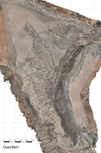
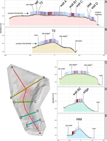
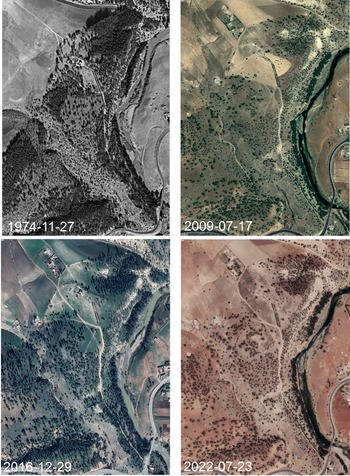
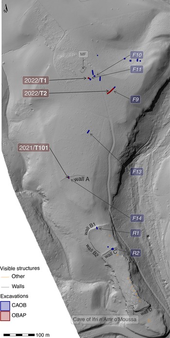
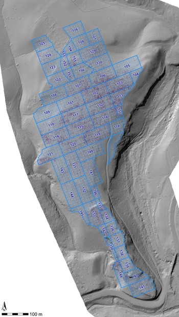
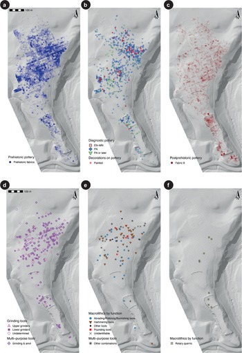


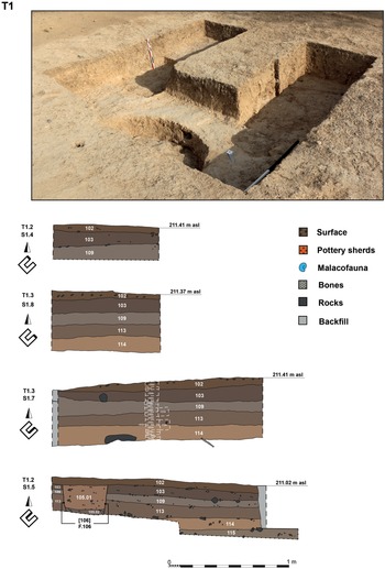


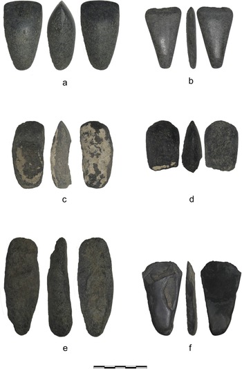


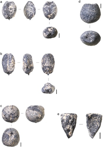


 Open access