


The island of Samos (Fig. 1) has been renowned throughout history for its networking and regional connections. As early as the end of the eighth century BCE, with the construction of the four ships for the Samians by the Corinthians (Thucydides 1.13.2–3) and with the building of Samos’ own fleet down throughout the subsequent 200 years,Footnote 1 Samos is considered to have been a naval superpower. The production of transport amphoras in regionally based workshops connected the island by the seventh century BCE into a trade network for agricultural goods that spread right across the Mediterranean basin.Footnote 2 Further afield, its strong connections from even the early days of the seventh and sixth centuries BCE with Egypt, Cyprus and the Levant, in particular, plugged the island into circulation networks of luxury products, many exceptional objects of which ended up dedicated in the sanctuary of Hera – the so-called Heraion.Footnote 3 Textual evidence takes one further down: at the end of the first millennium BCE, Samos was utilised as a Ptolemaic naval base, exploiting its strategic position in the East Aegean and its natural harbours; while in post-antique phases Samos became a key node in stopover and exchange between the Mediterranean and Near East worlds,Footnote 4 establishing strong international networks for the distribution of pitch, wine, honey, and other products into Northern Europe (Dapper Reference Dapper1703, 192; Tournefort Reference Tournefort1717, 307; Sonnini Reference Sonnini1801, 306; Tozer Reference Tozer1890, 162). Simply put, this modest-sized island located at the favourable intersection of the Aegean and Anatolian, the Mediterranean and the Near Eastern worlds, has been for long and sustained periods well-placed in its connections. Although a well-known story, if one were to interrogate the narrative, one might note that much of the evidence, both material and literary-historical, derives from both the Heraion, with 100 years of excavation and study from the German Archaeological Institute, and the various rescue excavations conducted around the town of Pythagoreio (the ancient polis of Samos).Footnote 5 To what extent, though, was the wider landscape of Samos integrated into these same worlds of production and connection? What role was played by the rural hinterlands in building and developing international networks?
Map of Samos, indicating the location of the island in the East Aegean, and of Karlovasi and Marathokampos on the island.

New data from the West Area of Samos Archaeological Project (WASAP) can help to answer just these questions in relation to south-west Samos.Footnote 6 That is, two seasons of intensive pedestrian field survey conducted in the Marathokampos basin of Samos have yielded a significant ceramic dataset, whose spatial distribution provides valuable information about ancient landscape organisation and whose dating and provenance suggest something of the shape of Samos’ international networking during different periods of its history. The final results of the project are published in various articles: for the first publication of the survey results from south-west Samos, see Christophilopoulou et al. Reference Christophilopoulou, Huy, Loy, Mac Sweeney and Mokrišová2025; and for a data release of all survey data see Loy et al. Reference Loy, Argyraki, Christofilopoulou, Delli, Evans, Huy, Katevaini, Mac Sweeney, Mokrisova, Regazzoni and Vasileiou2025. This article represents work-in-progress, using a representative sample of the survey ceramics to address three specific research goals:
-
• to compare one model of ceramic spatial distribution (the ‘Area of Interest’) against the ancient and post-antique material described in the landscape of south-west Samos by early travellers;
-
• to suggest, through the provenance and production types of a representative sample of survey pottery, how west Samos connected itself to or isolated itself from regional and extra-regional networks and neighbours between the Archaic and Early Byzantine periods;Footnote 7 and
-
• to relate the chronology, quantity and functional groupings of the ceramic landscape of west Samos to patterns known from the east of the island, specifically from the excavations of the Hera sanctuary.
A selection of project data is discussed here, where ID numbers indicated by bold typeface are datapoints that can be cross-referenced to the WASAP core dataset.Footnote 8 This article contributes further analysis and substantive conclusions further to a first data publication made by the project (Christophilopoulou et al. Reference Christophilopoulou, Huy, Loy, Mac Sweeney and Mokrišová2025). For the purposes of this article and for the limits of the area to be discussed, the ‘south-west Samos basin’ constitutes the area south of the village of Marathokampos, between the hamlets of Velanidia in the east and Limnionas in the west. For heuristic purposes and to assist in the discussion of the data and their patterning, the landscape as discussed here is divided arbitrarily into separate named areas, from east to west as Velanidia, East Kampos,Footnote 9 Agios Ioannis, West Kampos, and Limnionas, following a slightly different nomenclature to that employed by the project’s primary publications (see Christophilopoulou et al. Reference Christophilopoulou, Huy, Loy, Mac Sweeney and Mokrišová2025) (Fig. 2). Chronologies used in this article follow the general conventions used for the region by century (Table 1).
Map of the Marathokampos basin, indicating the names of the major areas mentioned in the text.

Chronology and date ranges used in this article.

THE LANDSCAPE OF SOUTH-WEST SAMOSFootnote 10
Ancient commentators note the importance of Samos’ landscape for its wealth of resources: from the author of the Homeric Hymn to Apollo who notes Samos for being well-watered (40–3), to Aeschylus extolling the island for its richness in olives (Persians 879–86), to Herodotus noting the supply of timber and stone on the island (3.47–60), perfect for the construction of warships, to Athenaeus describing the vine-covered hills of the island (Deipnosophists 13.71.47). Similar observations were made by the Early Modern travellers to the island: from stating that the island was abundant in myriad species of trees and flowers (Guérin Reference Guérin1856, 132–8), to noting that the soil on the north side is deeper and more the suitable for growing vines (Randolph Reference Randolph1687, 55).
The area immediately below the village of Marathokampos is a low-sloping terraced agricultural space, principally for the cultivation of olive trees. The town of Kampos was built up on the coast here in the 1980s, with major developments beginning already in the 1960s. Until its development as the town of Votsalakia (later Kampos), the environment here was poor, swampy, and very difficult to cultivate, with fields gifted by fathers to unfavourable children as ‘revenge’ (E015).Footnote 11 The old name of the area is ‘Kourkoudialotopos’, deriving from ‘batter’ and meant to describe the general condition of the landscape.
The crop now predominantly grown in the area is the olive. According to early written sources, there was a large area of cultivation around Marathokampos already in the mid-nineteenth century CE (Guérin Reference Guérin1856, 269), comprising both the fennel from which the village takes its name (marathos, fennel + kampos, plain; see also Lacroix Reference Lacroix1853, 220) and mixed crops. There existed an agricultural community in this area since at least the late seventeenth century (Georgirenes Reference Georgirenes1677, 17; Dapper Reference Dapper1703, 192), with the island in general having been noted for cultivating pitch, oil, honey, wines, and, in the late autumn months, a particular brandy popular for foreign export (Sonnini Reference Sonnini1801, 307). Agricultural activity of the area has declined in the most recent generation, with the focus of Kampos having now shifted to (international) tourism and development (E002).
There is a post-antique church above Kampos dedicated to Agios Ioannis, located beneath the hill of Kastri and long-noted as a point of interest in west Samos (Guérin Reference Guérin1856, 283–4; Kritikidis Reference Kritikidis1869, 54; Bent Reference Bent1886, 146–7). In an area whose terraces were once covered by monumental ‘Hellenic masonry’ and thought to be the location of ‘an extensive Greek town’,Footnote 12 nineteenth-century excavations brought to light both antique and Byzantine structures; the platform on which the chapel is constructed appears to be made from first millennium BCE monumental ashlar blocks (Fig. 3), and an excavation in the 1950s of this area reportedly brought to light black-glazed pottery (Shipley Reference Shipley1987, 254). Of the area from Agios Ioannis down to the coast, Victor Guérin (Reference Guérin1856, 283) reports seeing broken pottery, marble columns and remains of small walls roughly one kilometre from Agios Ioannis, and in the 1980s, too, Graham Shipley noted a carpet of ancient surface material (Shipley Reference Shipley1987, 254). Erosion of the whole area is stable, with possible built structures (some dating from the nineteenth or twentieth century) on the higher terraces (P081, P082, P083, P084).Footnote 13 There is much disturbance in the area: locally, there is a rubbish dump (primarily old tyres and some modern tiles) around the church, but at a wider scale the whole area has been subject to development. Reportedly, since World War 2 and before the development of Kampos, the military used to conduct demonstrations here, detonating controlled explosives (E002, E025), something that would have had a great effect on the presence and quality of standing remains.
Possible first-millennium ashlar blocks, on the foundations of the Agios Ioannis Church. Image taken as part of a set to produce a Structure from Motion (SFM) photogrammetry documentation of the structure.

The area called West Kampos is part of the same environmental landscape as the Agios Ioannis hinterland, albeit defined as a separate zone for the purposes of field investigation, as it was impossible, owing to the presence of modern buildings, to designate a continuous transect between Agios Ioannis and West Kampos. One coastal area has been explored here to date, to mirror the sample taken at the Velanidia coast on the other side of Kampos (see below), and a hilltop was also explored on the road towards the church of Panayia Sarandaskaliotissa (Guérin Reference Guérin1856, 282–3).
Velanidia comprises an area of medium-steep terraced ploughed fields above a basin of low-lying cultivation to the west and south (Fig. 4). The lowest areas of the basin (identified as a former river channel, P113) are thick with maquis and reeds. A massive post-antique aqueduct (P048) and abandoned mill are also known from this area (at the place known by the toponym ‘Kamares’),Footnote 14 with a number of old streams also identified here. The erosion of the terraces is less stable than at Kampos, yielding accumulated clusters of ceramic material on the lower slopes (P102, P104, P105). According to local knowledge, this area has not changed significantly since the 1940s, except from the construction of a reservoir in 1991 and the construction of some holiday cottages on the coast. Cultivated fields immediately behind these houses were still walkable, yielding very large quantities of very small sherds (suspected to be the result of ploughing the soil).
The plain of Velanidia, with the village of Marathokampos in the hills to the right of the picture. Taken from the approximate location of Vel-2 looking west. Image taken by Michael Loy.

The area between Kampos and Velanidia is here referred to in this article as ‘East Kampos’, although the project’s primary publication refers to this area as ‘Ormos’ (Christophilopoulou et al. Reference Christophilopoulou, Huy, Loy, Mac Sweeney and Mokrišová2025).Footnote 15 Terrain across the whole area varies between ploughland, fallow and dense maquis, with the area most directly south of Marathokampos comprising a fairly flat area of plough zones.Footnote 16 To the east of this area (in the environs of the reservoir), the ground is flatter with thin soil and thicker maquis. A dried-up river channel has been identified (P176), around which high densities of pottery have been located.
West from Kampos, the sheer topography of the cliff-face (above the modern-day beach of Psili Ammos) is completely inaccessible by foot. The next area suitable for investigation is around the hamlet of Limnionas, both on the slopes of the village and further down to the sea on the coastal promontories (Akra Chondros Kavos and Makria Pounta; Fig. 5), an area worth exploring for its landscape formations.Footnote 17 On either side of Akra Chondros Kavos, the spur provides a natural harbour where, notably, there is protection from high gale-force winds even when the rest of the south coast is buffeted.Footnote 18 There is disturbance in the area from the construction of a holiday village which, although similar in character, was less extensive than the development at Kampos. As a result of this little disturbance, there exist various standing remains and cut-features in the landscape, some possibly ancient in date (P152–P157). The main area next to the holiday village is gently sloping, unworked land of thin soils and low concentrations of fallow and maquis. Akra Chondros Kavos itself is steeper, with completely unworkable east and south sides, with other parts of the hill also closed off to private olive groves.
Natural inlet between Chondros Kavos and Makria Pounta. Project photo 2022-06-04-005.

INVESTIGATING SOUTH-WEST SAMOS WITH INTENSIVE PEDESTRIAN FIELD SURVEY
The following adapts the longer discussion of the data collection procedure outlined in Christophilopoulou et al. Reference Christophilopoulou, Huy, Loy, Mac Sweeney and Mokrišová2025. Intensive pedestrian field survey of the south-west Samos basin was conducted in 2021 and 2022.Footnote 19 According to the project methodology,Footnote 20 a grid was drawn pre-season by the Geographical Information Systems (GIS) team over the target area for survey, comprising 50 x 50 m grid-squares. A map of target grid-squares was given to field team leaders, along with relevant Universal Transverse Mercator (UTM) co-ordinates of grid-square corners to be located with Garmin eTrex10 GPS units. Any grid-square explored, in full or partially, was recorded as a tract. Tract exploration demanded the noting of various landscape features by a team leader (e.g. slope condition, erosion pattern, vegetation coverage), and the systematic exploration of the unit by a fieldwalker team. Fieldwalker teams consisted of five walkers, spaced at 10 m intervals along the 50 m baseline of a regular-sized tract. Fieldwalkers progressed as far as the landscape would allow, up to 50 m from one side of the grid to the other in regular formation and following a fixed compass-bearing. Fieldwalkers made for each tract a subjective estimate on the surface visibility, recorded arbitrarily as a percentage, where 100% is near-perfect sight of the ground on a clear ploughed surface or similar, and 1% indicates it was almost impossible to see anything on the ground through thick vegetation or fallen leaves.Footnote 21 Across each tract unit, fieldwalkers noted the total number of surface ceramics and tiles seen within a 2 m cone of vision either side of their line walked, entering all information in a tablet through the app KoBo Collect (Loy, Katevaini and Vasileiou Reference Loy, Katevaini and Vasileiou2024), and all ‘diagnostic’ pieces (rims, bases, handles, and decorated feature sherds) were collected for analysis.
The south-west basin of Samos was investigated by the WASAP survey in 2021 and 2022 in 804 regular- and irregular-shaped tract units, giving a coverage of 1.26 km2. In 2024, a team from the University of Vienna led by Naoíse Mac Sweeney covered an additional 12 tracts (0.1 km2) in the area of Velanidia (see below for toponym information); the results of these additional tracts are not discussed here, but are considered in Christophilopoulou et al. Reference Christophilopoulou, Huy, Loy, Mac Sweeney and Mokrišová2025. As continuous a transect as possible was explored across the Marathokampos basin, and, in addition, small ‘test transects’ were placed in various areas west of the main transect, based on ground features identified via Google Earth for in-person autopsy. Private property and sheer topography rendered large parts of this area as non-walkable, i.e. impossible for exploration with intensive survey methodologies. In total 1.41 km2 was marked as unwalkable, bringing the total area discussed in the present article to 2.67 km2 (Fig. 6).
Area covered in the Marathokampos basin by intensive-pedestrian field walking of the WASAP team, 2021 and 2022. Area not walked and non-walkable is marked in cross-hatching.

At Agios Ioannis, general visibility was deemed poor by fieldwalkers (an average subjective visibility score of 26%), owing for the most part to a dense area of maquis immediately west of the church.Footnote 22 Ground visibility on the terraces, by contrast, was fairly high (fieldwalkers usually reporting 70–90% visibility), yielding 1540 sherds across 104 tracts (325 of which were collected for study). At West Kampos, however, the visibility was better than at Agios Ioannis (35% visibility average), but the area overall fairly unproductive in terms of finds, with only 240 fragments registered across 59 tracts (27 of which were collected for study). General visibility across the whole of Velanidia gave an average of 37%, with the highest scoring areas on the terraces, in fields immediately west of the reed basin, and in the fields on the coast. This was the most productive area of the 2022 survey, yielding 19,950 sherds from 290 tracts (1461 of which were collected for study). By contrast, at East Kampos the average visibility was fairly high (33% fieldwalker average), ironically with the areas of highest ground visibility in the areas of modern disturbance, and lowest visibility around the area of the old river channel. And at Limnionas low levels of maquis and disturbance rendered the area a relatively high visibility score when walked in intensive survey (44%), with very low overall counts: only 172 pieces of pottery were counted across 81 tracts, from which 54 were collected (Table 2).
Summary of survey statistics from the main areas of the Marathokampos basin.

Exploratory spatial statistics have been calculated thus far at the level of the walkerline (Fig. 7), i.e. per every 50 m (or less) unit walked by each fieldwalker.Footnote 23 A ‘weighted walker line’ value was calculated by multiplying together the raw pottery count and visibility for each unit: this adjusts walker counts such that in areas of low visibility it is possible there existed sherds that, even though existing on the surface, might have been neither seen nor recorded. The walkerline was also adjusted relative to a walker’s own ‘personal statistic’,Footnote 24 data collected cumulatively on each walker throughout the season relative to their own collection habits in relation to their neighbour walkers within the same tract, accounting for the fact that some walkers might ‘overcount’ ceramics by including rocks in their total, or that they might ‘undercount’. This calculation provided an arbitrary decimal value that could be used to distinguish walkerlines by classification in GIS (Fig. 8). Furthermore, GIS was used to plot the collected ceramics collected on each walkerline:Footnote 25 count-per-tract had been recorded in the field, but precise location of findspot had not, and any visualisation of collected find locations is, therefore, an analytical unit subject to calculation errors.Footnote 26 Using the visualisation of weighted walkerlines and collected findspot location visualised together in GIS, an impressionistic estimate of finds clustering was made in the immediate off-season processing of the spatial data to sketch out ‘Areas of Interest’ (AOIs), ‘hot spot’ clusters where the weighted walker counts or findspots (or both) were particularly high: these AOIs were defined subjectively and not according to any formal statistical criteria.Footnote 27 AOIs are thus drawn heuristically in the field on the basis of unstudied and undated pottery; a more formal designation of survey sites in west Samos is made in the post-field analytical phase of the project using formal quantitative criteria (Loy and Vasileiou Reference Loy and Vasileiouforthcoming), but is not considered here. That is because one of the key research interests of this article is on how the initially defined AOIs now stack-up when the full pottery analysis has been conducted.
Interpretative diagram to illustrate the progression of fieldwalkers through regular- (50 x 50 m) and irregular-shaped tracts. Image: Anastasia Vassiliou.

Area of Marathokampos basin explored in survey, indicating classification of walkerlines according to the weighted statistic calculated.

Fifteen provisional AOIs have been defined to date in south-west Samos (Table 3; Fig. 9). Viewed from east to west: six AOIs at Velanidia related to high counts both of surface finds and of diagnostics collected. Vel-1 and Vel-5 were each eroding out of raised features covered in thick maquis, while Vel-2 yielded large and well-preserved pieces eroding out of terraces. Vel-3 and Vel-4 were accumulations at the bottom of hillsides, possibly related but hard to tell from the spatial distribution alone. Vel-6 was, however, entirely separate, and an area of coastal erosion. Of East Kampos, four AOIs were defined. EK-2, EK-3 and EK-4 were all accumulations from eroding hills, where EK-2 and EK-3, although non-contiguous areas, were eroding from the same hilltop. Fieldwalkers noted that material from these AOIs was fairly homogenous, whereas that from EK-1, an accumulation around a dried river, was much more mixed. EK-1, at least, is still within the 1 km carpet of ceramics from Agios Ioannis noted by Guérin. From the Agios Ioannis area proper, AI-1 is a dense carpet of material radiating from beneath the foundations of the church, while AI-2 appears to be eroding out of a hillside from the north. This area is non-contiguous with West Kampos, where the only AOI defined was on top of the far hilltop explored (WK-1), defined for the number of diagnostics collected here and because fieldwalkers noted the material they collected from here looked significantly different to what else had been collected in the rest of the survey. At Limnionas, Lim-1 encapsulated an area of surface sherd counts relatively high for the area and dense in the distribution of Points of Interest (POIs) recorded. Lim-2 was defined for the cache of sherds collected as P150, but counts and diagnostics were otherwise low here.
Areas of Interest (AOIs) defined in the Marathokampos basin from initial spatial data processing, with indication of size and density of pottery for each unit.

Location of all Areas of Interest (AOIs) defined in the initial spatial data processing. Survey universe including walkable and non-walkable areas is marked in blue.

Of what was previously known before the field season, AI-1 (and possibly EK-1) is the Agios Ioannis site (Guérin Reference Guérin1856, 283–4; Kritikidis Reference Kritikidis1869, 54; Bent Reference Bent1886, 146–7; Shipley Reference Shipley1987, 254), but beyond the ashlars on the uppermost level of terracing next to the chapel, none of the architectural members mentioned by previous writers were located. Vel-6, for its proximity to the aqueduct, most closely fits the description of Shipley’s (Reference Shipley1987, 254) ‘Kamares’. Vel-2 and Vel-3 were known locally (E001, E002) but had not been formally documented. The remaining 10 AOIs can be considered newly discovered as of 2022.
Chronological and spatial patterning
The primary presentation of each of the survey zones in south-west Samos and an overview of results is presented elsewhere in this volume (Christophilopoulou et al. Reference Christophilopoulou, Huy, Loy, Mac Sweeney and Mokrišová2025), with the detailed quantification and the typo-chronological profile of each zone in in the section individually authored by Huy. The results are summarised here (Fig. 10), and the respective figures are given. The following discussion is based on this and aims to discuss the application of the initially designated AOIs.
Weighted bar plots summarising the quantity of wares by date found at each of the main areas of Marathokampos basin.

Archaic pottery was distributed fairly widely across the survey universe (Fig. 11a; Table 4), with the most prominent concentrations at Velanidia, and with not a single sherd of diagnostic pottery found in the tracts of West Kampos nor at Limnionas.Footnote 28 The highest concentrations fall within AOIs Vel-1 (100% of all datable diagnostics collected) and Vel-4 (31.3%; five pieces), with significant numbers also found at Vel-3 (13.2%; five pieces) and Vel-5 (7.8%; five pieces). Although in lesser overall numbers, there were positive indicators of Archaic pottery found at EK-1 (18.8%, the most significant total for this AOI behind the ubiquitous Byzantine pottery; three pieces) and EK-3 (6.3%). In almost all cases pottery fragments were transport amphoras nearly exclusively of the regional Samian-Milesian type. High quantities of Archaic tableware were found at Vel-1 (42 out of 45 diagnostics dated to the Archaic period) and Vel-5 (three out of five). Only one single piece was found outside of Velanidia (1006-5-1), just above the formal designation of AI-1. The Archaic tableware consists predominantly of typical Ionian shapes, among these drinking vessels with simple band decoration and, first and foremost, cups with everted rim (so-called Knickrandschalen, dominated by types 5, 6 and 9 according to Schlotzhauer Reference Schlotzhauer2014) (Archaic types, see Huy in Christophilopoulou et al. Reference Christophilopoulou, Huy, Loy, Mac Sweeney and Mokrišová2025, figs 16–18a, 22ab). The tableware covers the period between the mid-seventh and the late sixth centuries BCE.
Distribution of diagnostic sherds: a) Archaic period; b) Classical period.

Counts of diagnostic ceramic sherds at AOIs according to period and percentage thereof of total dateable diagnostic assemblage: a) all ceramics by period; b) amphoras and tableware separately by period

Classical pottery was found in much lower quantities than Archaic, but the spatial patterning is similar (Fig. 11b; Table 4). Like the Archaic pattern, there were positive indicators at both EK-1 (12.5% of all datable diagnostics collected; two pieces) and EK-3 (2.1%; one piece). Unlike the Archaic distribution, though, the pattern at Velanidia was different. Classical pottery was found almost exclusively at Vel-2 (15.5%; 11 pieces), with a few pieces at Vel-5 too (3.1%; two pieces); pieces securely dating to the Classical period were absent from Vel-3 and Vel-4; but sherds whose dating covers multiple periods and not exclusively the Classical (e.g. 2076-2-2, 2187-3-4) do originate in these areas. The difference in the distribution of amphoras versus tableware is not so stark for the Classical period as for the Archaic, with examples found both across Velanidia and at key points in East Kampos; but the lower number of examples makes it difficult to ascertain how strong this pattern actually is. The AOIs reflect the same types with mushroom rim type amphoras and black-glazed drinking cups and skyphoi, some of which are Attic. There are no finds from the first half of the fifth century BCE and the amount increases slightly in the fourth century (Classical types, see Huy in Christophilopoulou et al. Reference Christophilopoulou, Huy, Loy, Mac Sweeney and Mokrišová2025, figs 18c–i).
At Velanidia, Hellenistic pottery (Fig. 12a; Table 4) was also found in its highest concentrations around Vel-2 (33.8% of all datable diagnostics collected; 24 pieces), with a few pieces also found at Vel-3 (13.2%; five pieces) and Vel-5 (4.7%; three pieces). Further pieces, both amphoras (2175-5-1; Huy in Christophilopoulou et al. Reference Christophilopoulou, Huy, Loy, Mac Sweeney and Mokrišová2025, fig. 19c) and tableware (2168-5-3), were also found south of Vel-5, but outside the limits of the dense scatter of Vel-6. Hellenistic pottery was also present across most AOIs of East Kampos, at EK-1 (6.3%; one piece), EK-2, (6.3%; one piece) and EK-3 (2.1%; one piece); and further west at AI-1 too (2.6%; two pieces). A mixture of amphoras and tableware was found in most areas investigated, with the only notable difference being that fewer amphoras were found across East Kampos, and that of the pieces located in Limnionas only tableware was found. The tableware is mainly represented by plates and bowls of colour coated ware covering the entire period alongside two fragments of Knidian carinated bowls of the late second/first half of the first century BCE. Among the amphoras are both Hellenistic mushroom rim and rounded rim types along with some fragments of household and cooking ware (Hellenistic types, see Huy in Christophilopoulou et al. Reference Christophilopoulou, Huy, Loy, Mac Sweeney and Mokrišová2025, figs 19a–j, 22c–e, 23a–d).
Distribution of diagnostic sherds: a) Hellenistic period, b) Roman period.

Roman-period pottery was found in relatively low abundance across the survey universe (Fig. 12b; Table 4), but there is enough of a dataset to distinguish at least some very loose spatial patterns. Roman pottery was found across almost all AOIs of Velanidia, at Vel-2 (7.0% of all datable diagnostics collected; five pieces) and Vel-3 (13.2%; five pieces), with the highest concentration originating from Vel-5 (stats). Very few pieces of transport amphoras were found south of Vel-5, but in lesser abundance than the pieces of Hellenistic pottery found in the same area. Roman-period pieces were also located at EK-3 (4.2%; two pieces) and EK-1 (12.5%; two pieces), but this is the first period, chronologically speaking, for which no pieces were found at EK-3. AI-1 contained Roman-period material (6.4%; five pieces), but only from the areas in the southern limits rather than distributed across the whole AOI. The pieces were mostly amphoras, alongside some large bowls and cooking pots. No Roman tableware derived from the survey in 2022. The few amphoras are represented by the early Roman pan-Mediterranean type Dressel 2–4 and individual examples of the later types Agora M 54, Dressel 24, Kapitän II and Africana III (Roman types, see Huy in Christophilopoulou et al. Reference Christophilopoulou, Huy, Loy, Mac Sweeney and Mokrišová2025, figs 19k–m, 23e–g). Byzantine and later pottery, by contrast, was so abundant across the survey universe (Fig. 13; Table 4) that it is difficult for the opposite reason to distinguish neat spatial patterns. Byzantine pottery was found at almost all AOIs for Velanidia. The concentrations at both Vel-2 (33.8% of all datable diagnostics collected; 24 pieces) and Vel-3 (55.3%; 21 pieces), and at Vel-5 (82.8%; 53 pieces) were not neatly bounded within the areas defined by the AOI, but in the former case spread further to the west, and in the latter further to the south. By contrast, Vel-6 (97.0%; 64 pieces) comprised pottery of almost exclusively the Byzantine period, as was similarly the case for EK-4 (100%; six pieces). Large amounts of Byzantine pottery occupied EK-3 (85.4%; 41 pieces) and EK-1 (50.0%; eight pieces), although for EK-2 (93.8%; 15 pieces) the density of material was actually less than it had been for previous periods. At Agios Ioannis, Byzantine pottery was quite ubiquitous, covering almost the entire extent of AI-1 (89.7%; 70 pieces) and AI-2 (100%; 7 pieces). For West Kampos, Byzantine diagnostic pottery was found in all parts of this zone (body sherd with turquoise lead glaze: 2014-3-1 on the lower slopes; Early Modern body sherd: 2230-5-1 on the upper slopes; body sherd with olive green lead glaze: 3183-2-1 within the bounds of WK-1), in areas where pottery of no other period had been detected, a similar case as on the slopes of Limnionas (Early Modern body sherds: 2240-5-1, 2250-1-1), albeit there with the presence of Hellenistic pottery too. There was little overall difference in the distribution of transport amphoras and tableware from Velanidia, while there is a marked difference in that East Kampos was more populated by tableware (at EK-2, EK-3 and EK-4, over half of the pottery collected in each sample was tableware, at 87%, 73% and 67% respectively) and Agios Ioannis by amphoras (86% of the total Byzantine assemblage for both AI-1 and AI-2). The majority of the Byzantine to Early Modern material found further west of Agios Ioannis was tableware, although not without a few body sherds of amphoras on the slopes of Limnionas (2237-1-1). The majority of the pottery can be dated to the early Byzantine period. Tableware is especially made up of the large dishes of the Phocean Red Slip ware of Hayes Late Roman C (LRC) forms 3 and 10 (mid-fifth–mid-seventh centuries CE). The amphoras are dominated by the contemporaneous Samos Cistern type and the slightly older Agora M 273 type, alongside Late Roman Amphorae (LRA) 1 and 2 and Aegean Globular amphoras (Byzantine types, see Huy in Christophilopoulou et al. Reference Christophilopoulou, Huy, Loy, Mac Sweeney and Mokrišová2025, figs 20, 21a–c, 23h–j, 24a–f, 25a).
Distribution of Byzantine period diagnostic sherds.

In summary, the first millennium BCE of south-west Samos is overall much less represented than the first millennium CE. The most considerable quantity of first millennium BCE pottery – i.e. Archaic – comes from the zones of Velanidia and East Kampos. The amount of ceramics from the Classical and Hellenistic periods, as well as from the Roman period, is, furthermore, much less significant. In terms of raw counts alone, the chronological distribution could suggest that both areas were occupied since the Archaic period, but that this occupation declined in the fifth century BCE. It was not until the Early Byzantine period that the occupation intensified again.
The finds from Agios Ioannis differ from other parts of the survey universe in that they date almost exclusively from the Early Byzantine period. The lack of older material could be related to the limiting of the survey area by modern construction, or, even in open areas, through landscape disruption caused by local building or military activity. Some sort of recent local taphonomic change is likely, given that as recently as the 1980s Shipley saw material in the immediate vicinity of the church dating between the Archaic and Hellenistic periods, including highly diagnostic Attic black-figured and black-glazed wares (Shipley Reference Shipley1987, 232–6, 254, map ref. 9504). Middle, Late and post-Byzantine finds were few and far between at all AOIs and do not allow for further interpretation. The presence of Modern cooking vessels with lustrous red glaze clearly points to the use of all AOIs in the recent past (Modern types, see Huy in Christophilopoulou et al. Reference Christophilopoulou, Huy, Loy, Mac Sweeney and Mokrišová2025, figs 21d–h, 22g–k, 24g–i, 25d–g).
Among the functional categories of tableware and transport amphoras, generally the same types of vessels were used in the different areas. A particularly striking feature of all areas is the complete absence of Roman sigillatas, which can hardly be regarded as a bias in collecting practice given the shiny red glaze, easily recognisable on the ground. Rather, it underlines a decline in activity at the areas, which is also reflected in the small number of finds. The small number of cooking vessels and transport amphoras could therefore be interpreted as the remains of small dwellings, probably only used seasonally by farmers during periods of agricultural work.Footnote 29 From about the fifth century CE, when the number of finds increases significantly, glazed tableware is again ubiquitous. It is possible that it was during this period that permanent settlements were again established in south-west Samos.
To make some more general comments on patterns of visibility and bias: the authors do not believe that the more surprising or unexpected patterns found in the assemblage are reflective of a gap in the dataset nor from a collection bias for certain types of ceramic. In the field, the directors and experienced team leaders regularly took a sweep along the fieldwalker lines to check the material that was being recorded and collected;Footnote 30 from this practice, it would appear that no major groups nor types were missed.Footnote 31 Furthermore, the assemblage viewed holistically indicates a wide range in terms of sherd size, colour, decoration and shape, such that no one group seems significantly over-represented. If there were a collection bias, it would likely be for large, highly recognisable amphora sherds. Any bias could not change the general observation, though, that Velanidia really is highly populated by these pieces, where significant amounts of tableware, alongside some cooking pots and household ware, were also found. There may be some bias against prehistoric ceramics, whose quality might be so abraded that the shape is lost and diagnostic fabric type unrecognisable. Until 2022 only one body sherd of presumably Early Iron Age hand-formed pottery was found (2362-4-1).Footnote 32 If there was a bias against collecting such pieces as diagnostic ceramics, it is expected that the picture will be corrected in the further processing and study of the survey material: ‘fabric samples’ – representative samples of each fabric group observed within a tract – were also collected in addition to diagnostic sherds which, although currently unstudied, might have within their assemblage prehistoric pieces that were not recognised in the field. Finally, there was a noticeable bias for the collection of amphora body sherds of the Early Byzantine period, with their highly diagnostic ridged design. Such pieces were ultimately discounted in the statistical calculation; but some modest over-collection in this area would not shift the narrative about a strong and ubiquitous Byzantine presence across the landscape. Therefore, while visibility and bias are important to bear in mind qualitatively in the interpretation of the data, their effect does not seem so great as to mask or distort general quantitative patterns.
Verifying the AOI as a unit of measure
By combining the ceramic and spatial patterns, it is possible to consider how useful the initial designation of various AOIs across the landscape was. That is, the dating of material concentrated within various AOIs can be used to plot multi-period activity across the whole landscape of south-west Samos (Figs 14 and 15).Footnote 33 In doing so, one must account for the fact that the representation of Byzantine pottery is far greater than that of other periods, and that even a proportion within the range of 10–30% of ceramics from the whole assemblage dating to some other period is a strong indicator of a site; whereas for the Byzantine period a proportion of greater than 80% is more useful as a strong indicator of a site. Presence of ceramics in lower proportions than these are indicative either of less densely defined AOIs or of AOIs whose secure dating can be debated (i.e. that the ceramics could have been so located in the landscape through some other taphonomic factors).
Location of all AOIs identified in the Marathokampos basin, designated by date. AOIs marked with a spot in the centre of their marker are less certainly defined.

Location of all AOIs identified in the Marathokampos basin, designated by date. AOIs marked with a spot in the centre of their marker are less certainly defined.

Archaic-dominant AOIs are principally located in Velanidia, both at the top of the hill and lower by the main road. One AOI in East Kampos has strong indicators of being an Archaic site, while two others are possibly Archaic although lower in concentration of material. The spread of Classical AOIs is similar, albeit smaller, and with a greater number of small/dubious AOIs. The spread is the same again for the Hellenistic period, although AOIs in East Kampos are all only tentatively defined. In addition, two areas not initially identified as AOIs should be included, the first underneath the modern road and above Vel-6, and the second on the slopes of Limnionas. The spread contracts in the Roman period back towards Velanidia: coastal AOIs are more tentatively defined, with the most clear AOI being the basin-accumulation at the foot of the Velanidia terraces. For the Byzantine periods, there is a spread across the whole landscape of AOIs, all quite securely defined. For the AOIs higher up the hill at Velanidia, though, the identification is less certain, and the greater concentration of AOIs is towards the coast and immediately above Kampos village.
The sample of diagnostic dateable ceramics from each site is fairly low, which makes it difficult to say much about functional groups or the nature of AOIs. However, given the outstanding high amount of Archaic tableware at Vel-1, including delicate pieces of Attic black-figured and Fikellura ware alongside painted roof tiles and a scarab, it is clear that the Archaic site at the top of Velanidia is of a completely different type of AOI to the Classical/Hellenistic Vel-2 and multi-period Vel-5, which are both dominated by transport amphoras. In Vel-1 the character of the Archaic finds indicates practices quite distinct from other parts of the survey investigated to date, which might be indicative of a cultic site (see the presentation of the assemblage in Huy in Christophilopoulou et al. Reference Christophilopoulou, Huy, Loy, Mac Sweeney and Mokrišová2025). The few vessels from East Kampos, consisting predominantly of cooking vessels and transport amphoras with no tableware nearby, do not reflect a normal settlement assemblage. Previous commentary on west Samos has suggested that the area was only permanently settled since the Late Hellenistic/Early Roman period (cf. Shipley Reference Shipley1987, 236). On the basis of the first systematic survey evidence, this hypothesis would appear to be correct but can also be extended. With the exception of those from Velanidia, none of the AOIs contained an assemblage that would indicate a permanent settlement before the Early Byzantine period. Prior to that, we tentatively suggest a more seasonal than permanent usage of the AOIs. Agios Ioannis is almost universally dominated by transport amphoras and tableware of the Early Byzantine period, something that is more consistent with the idea of a settlement, as postulated by previous visitors to the site. The sample from Limnionas and West Kampos is too small for comment.
The study of the material culture has helped to clarify some of the discussion points raised by the spatial distributions. First, there was the question on whether Vel-3, Vel-4 and Vel-5 were related at all, very proximate AOIs, where Vel-3 and Vel-4 were possibly accumulations from the same context. Vel-1 appears to be something quite different to the other AOIs, highly concentrated by Archaic period sherds, while Vel-3 displayed a continuous sequence right down from the Archaic through Byzantine. Vel-3 and Vel-5 are fairly similar in composition with very high quantities of only Archaic and Byzantine sherds, possibly deriving from the same context, albeit the former is a basin accumulation and the latter is erosion out of maquis; this would suggest very major landscape changes in the area, if true. EK-1, by contrast, has a very high ratio of Archaic and Classical pottery. It is also located fairly close to Agios Ioannis church, c. 800 m east. This is within the range of Guérin’s one kilometre radius, and it is actually possible that it could be part of the distribution he noted, and of the Archaic/Classical material noted by Shipley at Agios Ioannis but otherwise absent at AI-1 and AI-2. One hypothesis is that the landscape immediately around Agios Ioannis has been more disturbed and now only the largest and most robust (later, Byzantine) pieces are preserved on the surface, while EK-1 has been subject to less disruption and could represent more fully the ‘original’ pottery assemblage as seen by other commentators in the area. Further in East Kampos, it was suggested above that EK-2 and EK-3 could have been eroding out of the same hill. The assemblage of each AOI, though, is so different that this hardly seems likely, unless one considers a very sizeable Archaic or Byzantine site that enveloped a much smaller Classical/Hellenistic/Roman site.
THE POTTERY OF SOUTH-WEST SAMOS IN A LOCAL, REGIONAL, AND SUPRA-REGIONAL CONTEXT
The spatio-temporal distribution pattern of the pottery in the landscape of south-west Samos will now be considered against the ceramic profile of the entire island and beyond. We address the connectivity and entanglement of south-western Samos in regional and extra-regional networks, firstly through an evaluation of Samian pottery production, and secondly by comparing the survey with pottery assemblages from other parts of the island.
Samian pottery production
There is no doubt that Samos island was home to an extremely rich production of ceramics.Footnote 34 However, we know very little about production sites and resource deposits such as clay beds. Most of our knowledge is based on the sheer number of specific types, and the simple conviction that such a powerful and large island with a sanctuary of supra-regional importance would have produced vessels and votive offerings. Evidence that can be used to verify or challenge this presumption is best provided by archaeometric provenance analysis or by finds that could indicate the existence of pottery workshops (e.g. production tools or misfired sherds). Furthermore, where there are very high quantities of a given type widespread across the island, reliable indicators of production can be given, too. On this basis a general overview of the local production of tableware and transport amphoras can be given.Footnote 35
Trace element analysis by neutron activation and X-ray fluorescence has generated chemical patterns that are convincingly linked with the island.Footnote 36 NAA pattern SamJ was established as Samian production through the special vessels with dipinti of dedications to Hera, found exclusively in the Hera sanctuaries of Samos and Naucratis. The same signature was found in Archaic household wares, transport amphoras of the well-known Samian variant and tableware (mostly with those with simple band decoration, i.e. mugs and Knickrandschalen).Footnote 37 The evidence from the Hera dipinti suggests that the NAA pattern SamJ was produced in the Heraion or the surrounding plain (Kerschner and Mommsen Reference Kerschner, Mommsen, Smirnova, Vakhtina, Kashuba and Starkova2018, 310–11). This is also indicated by finds of overfired tiles and vitrified sherds in Archaic layers of the sanctuary.Footnote 38 Other production areas were situated in the ancient polis of Samos (see below) and can also be assumed at least for the areas of Mavratesi (near Chora) and Karlovasi in the north-west of the island. Clay deposits in these areas were still being used by potters in the second half of the twentieth century CE, but probably not in ancient times (Hampe and Winter Reference Hampe and Winter1965, 151–2; Dupont Reference Dupont1983, 26–7).
The situation of production in the post-Archaic periods is less clear. Kreuzer (Reference Kreuzer2019, 51–2) states that there is no evidence for local fine ware during the fifth century BCE in the Heraion. From the late fifth century BCE onwards, the demand for black-glazed pottery increased significantly, and in layers of the fourth century BCE this class is so frequent that local workshops seem to have started a production in Attic style. Technau described the fabric as ‘distinctly local’ and the glaze as dull and brownish (Technau Reference Technau1929, 41–8; Tölle-Kastenbein Reference Tölle-Kastenbein1974, 150; Isler Reference Isler1978, 105–9). These observations are hardly surprising, given the local production of Attic-style black-glazed pottery, which was appearing throughout the Mediterranean at that time (cf. Cook Reference Cook1965; Trinkl Reference Trinkl, Tsingaarida and Viviers2013).
Evidence for the production of Classical/Hellenistic transport amphoras comes from stamped handles that show Samian coin types.Footnote 39 Two pieces with lion-mask stamps have the rim preserved, proving the local production of mushroom rim type amphoras. They are dated to the years between 310 and 300 BCE (Grace Reference Grace1971, 55, 6, nos 10–11). Another example with a prow-stamp preserved a thick rolled rim, which Grace (Reference Grace1971, 83, pl. 15:15) tentatively dated to the third century BCE. The production of a Hellenistic type is further confirmed by a papyrus from the Zenon archive (P.Cair.Zen. 1.59015.recto): Samian and Milesian vessels are listed in the list of incoming oil deliveries, although we cannot draw any conclusions about the type.
We may safely assume a local production of colour-coated ware – the everyday tableware in the Hellenistic world – as such vessels are ubiquitously found on Samos (Tölle-Kastenbein Reference Tölle-Kastenbein1974, 158–9). Isler (Reference Isler1978, 113–14) also expects the local production of West Slope and relief ware. The latter is proven by the find of a pottery kiln in the area of the city of Pythagoreio that contained a fragmented mould of a relief bowl (Tsakos Reference Tsakos1973, 537–40).
Older literature on Roman pottery identified Samos as the producer of the ware we now call Eastern Sigillata B (ESB), because terms such as ‘vasa samia’ or ‘testa samia’ were used by ancient authors (cf. Bes Reference Bes2015, 16–17). It is now clear that ESB was produced in the Meander Valley on the neighbouring mainland. There is no evidence yet on Samos for the production of Roman tableware, nor for transport amphoras.
In the Early Byzantine period Samos was one of several production centres of Agora M 273 and Samos Cistern type amphoras (Arthur Reference Arthur1990; Bezeczky Reference Bezeczky2013, 156–8). There is currently no information on the production of tableware. Dupont (Reference Dupont1983, 27) suggests that there were Byzantine workshops at the entrance to the Eupalinos tunnel, but does not report reliable evidence. The publication on the tunnel finds (Hautumm Reference Hautumm2004) does not deal with questions of pottery production.
In summary, the following types of tableware and transport amphoras that are found in the survey are generally acknowledged as part of the island’s pottery production:
-
• Archaic (mid-seventh–late sixth centuries BCE): tableware with band decoration (mugs, bowls, Knickrandschalen,Footnote 40 plates, jugs) and Samian-Milesian type amphoras (see Huy in Christophilopoulou et al. Reference Christophilopoulou, Huy, Loy, Mac Sweeney and Mokrišová2025, figs 16, 17e–j, 22a–b).
-
• Classical (second half fifth–second half fourth centuries BCE): black-glazed tableware (skyphoi, bowls) and mushroom rim type amphoras (Huy in Christophilopoulou et al. Reference Christophilopoulou, Huy, Loy, Mac Sweeney and Mokrišová2025, fig. 18cehi).
-
• Hellenistic (second half fourth–first half first centuries BCE): colour-coated tableware (bowls, fish-plates, projecting-rim plates) and mushroom rim and rounded rim type amphoras (Huy in Christophilopoulou et al. Reference Christophilopoulou, Huy, Loy, Mac Sweeney and Mokrišová2025, figs 19a –egh, 22c, 23a–d).
-
• Early Byzantine (fourth–seventh centuries CE): Agora M 273 and Samos Cistern type amphoras (Huy in Christophilopoulou et al. Reference Christophilopoulou, Huy, Loy, Mac Sweeney and Mokrišová2025, figs 20i –k, 24a–f).
Pottery of fabric group 1. a: Archaic amphora of Samian variant, found in East Kampos; b–c: Classical and Hellenistic mushroom rim type amphoras, found in Vel-5; d: Hellenistic rolled rim plate, found in AI-1; e: pre-Roman large bowl, found in Velanidia (not within an AOI).

Pottery of fabric group 2. a–b: Archaic jug and cup, found in Velanidia (not within an AOI); c: Classical mushroom rim type amphora, found in Vel-5; d: undated beehive, found in Vel-4; e: Early Byzantine amphora of Agora M 273 / Samos Cistern type, found in Vel-3.

Pottery of fabric group 3. a: Early Byzantine amphora of Agora M 273 / Samos Cistern type, found in Lim-1; b: Early Byzantine lamp of Asia Minor group, found in Vel-6; c–d: Early Byzantine amphora of Samos Cistern type, found in AI-1; e: Middle Byzantine plate of green and brown painted ware.

Pottery of fabric groups 4 and 5. Group 4: a–b: Modern jug and mug of slip painted ware, found in Vel-3. Group 5: c: Archaic bowl, found in Velanidia (not within an AOI); d: Archaic amphora of Samian variant, found in Velanidia (not within an AOI); e: Archaic amphora of Samos-Milesian type, found in Vel-2.

The ceramic fabrics
The presentation of the fabric groups from the survey ceramics is an important datapoint towards developing a better recognition of Samian pottery outside the island. Ceramic fabric relates to the properties of the fired clay, i.e. after the raw clay has been washed, tempered and fired. It mainly depends on decisions made by the potter during the production of a vessel, including the choice of a raw clay deposit with its geological composition, how the clay is further processed and prepared before forming the vessel (filtering coarse particles, adding tempering agents, mixing different raw clays, kneading to remove air bubbles, etc.), and the atmosphere and temperature of the firing.Footnote 41 Macroscopic fabric classification was carried out routinely during the processing of the finds, using a 10x magnifying glass. Selected pieces were investigated with a 20–30x magnification microscope, and photographs were taken using this same equipment. Important criteria to be noted were temper, type of inclusions, quantity and sorting of inclusions, texture and colour (using Munsell Soil Colour Charts). Similar specimens were grouped together and, where possible, linked to a specific production region. The link of fabric groups to Samos is undertaken along three lines: 1) archaeological reasons: the ubiquity of a fabric group in the survey universe and its occurrence in all periods and vessel types; the represented vessel type, which is established in the range of Samian productions as elaborated above; 2) the comparison to published fabric descriptions that are considered as Samian; 3) the comparison to fabrics of Samian provenance, established via archaeometric analysis.
Assuming that potters sourced their clay from the surrounding area and stuck to known more-or-less identical recipes, it is reasonable to assume that fabrics from a given region reflect the local geology. The fabric groups that we consider as Samian fit well with the geology of Samos, which consists of sandstones and limestone deposits interspersed with crystalline schists in the southern area. In the western part of the island, a large section of limestone conglomerates and clays with units of marbles and mica-schists extends from the Karlovasi plateau to the Gulf of Marathokampos, with some volcanic rocks and porphyries. East to the central mountains are travertine limestones, tuffs and volcanic rocks (Arthur Reference Arthur1990, 284; Whitbread Reference Whitbread1995, 123–4). However, on the basis of macroscopic hand specimens, it is hardly possible to isolate the local Samian pottery production from the neighbouring Ionian mainland in Asia Minor. A typical feature of southern Ionian pottery is the porous, sandy texture found in most of the fabric groups, and the kind of inclusions are mostly the same. This is because the geological environments as well as the pottery traditions are very similar. Hence, macroscopically, the fabrics of Samos, Miletus, Ephesus and other sites in that region cannot be distinguished with certainty (cf. Kerschner and Mommsen Reference Kerschner, Mommsen, Brandt, Gassner and Ladstätter2005, 126), and the attribution to Samos remains hypothetical without in-depth archaeometric provenance analysis.
Five main fabric groups of possible Samian production were identified.
1. Buff sandy, medium-grained with large voids (Fig. 16)
This smooth fabric consists of a sandy, laminated texture with various pores and few large voids. Abundant smaller and larger inclusions, of which limestone, quartz and iron oxides predominate, with silver mica and calcite occurring in moderate amounts. The colour of the sherds ranges for the most part between reddish yellow to reddish brown or light-brown (5YR 6/4–6/6; 7.5YR 6/4–6/6; 10YR 6/4), sometimes with a grey core (10YR 5/1).
This fabric is common among the survey finds and appears in Archaic–Hellenistic vessels, not restricted to a certain type. Included are Archaic amphoras of the Samian variant, Classical–Hellenistic mushroom rim type amphoras, Hellenistic tableware and common ware of the first millennium BCE.
2. Reddish, fine-pored with oblong voids (Fig. 17)
This is a more fine-grained fabric with a quite even fraction (few oblong voids). The slightly porous texture contains inclusions of different sizes, unevenly spread: sand, crushed lime and small iron oxides, interspersed with silver mica and very few larger white limestones and light grey quartzites. The colour ranges from yellowish red to light red (5YR 5/6–2.5YR 5/6).
The group is very common among the survey finds and is not restricted to any period or vessel type. The group is consistent with previously given descriptions of pieces that are supposed to be from Samos.Footnote 42
3. Buff hard, dense and fine-grained (Fig. 18)
The fabric is very hard fired and fine grained with a splintery fracture. The dense texture is well sorted and consists of sand and crushed lime, silver mica and iron oxides with a few larger inclusions. The colour range is between reddish yellow to light reddish brown and pinkish grey (5YR 6/6–6/2) and very pale brown (10YR 7/3–4).
The fabric appears only in Early Byzantine and later sherds, but was found in both tableware and amphoras (Agora M 273 and Samos Cistern types). It is very much in line with the descriptions of the Samos Cistern type given by Williams (Reference Williams1990) and Bezeczky (Reference Bezeczky2013, 157).
4. Orange-red, hard fired, clean break (Fig. 19ab)
This is an extremely hard-fired fabric with clean breaks and a lack of sand. Typical are oblong voids and the few well-defined inclusions of lime, quartz and iron oxides. The colour spectrum is fairly uniform and compares to that of group two with rich orange-red tones (reddish-yellow 5YR 6/6; 6/8), sometimes a little buff.
The fabric is common in south-west Samos and seems to be limited to Modern pottery. It shows some similarities with group two in terms of colour and the kind of inclusions.
5. Purple, hard fired with limestone and volcanic rock (Fig. 19c–e)
This is a distinct fabric of hard fired, dense and slightly sandy texture with conspicuous large limestones and volcanic rock. The colour spectrum tends to be somewhat darker than that of the other groups, with shades of purple-red and brown: from pink to light reddish brown, reddish brown and reddish grey (7.5YR 7/3; 5YR 6/4; 5/4); sometimes darker core, weak to dusky red (2.5YR 4/2–3/2).
This small group is currently found only in Velanidia and exclusively consists of Archaic vessels. These are mostly tableware with painted band decoration but there are also Samian-Milesian type amphoras.
There are several minor groups, each represented by only a handful of pieces. They probably also come from southern Ionia, as they all share similarities with the five main groups and the pieces in them belong typologically to the southern Ionian production (amphoras of the Samian-Milesian, the mushroom rim and the Samos Cistern types). However, a more precise attribution of origin is not possible. One of these groups contains Archaic tableware and amphoras and seems to be consistent with the fabric of the NAA pattern SamJ, possibly from the Heraion region (Fig. 20a–c).Footnote 43
Undefined fabrics: a: Archaic cup with everted rim (Knickrandschale), type 9,3.C, found in Velanidia (not within an AOI); b: Archaic amphora of Samian variant, found in Velanidia (not within an AOI); c: Archaic amphora of Samos-Milesian type, found in Velanidia (not within an AOI); d: Late Archaic / Early Classical amphora of Chios type III-B, found in Velanidia (not within an AOI); e: Classical amphora of Chios type IV-A, found in Velanidia (not within an AOI).

A few fabrics, some identified in conjunction with the type, show clear signatures of other regions, including three fragments from Chios (Fig. 20de) and Klazomenai from northern Ionia, individual pieces from Campania (Dressel 2-4) (Fig. 21a) and Tunisia (Africana III-B), as well as several LRA 1 from the eastern Mediterranean (Cilicia / Cyprus) (Fig. 21bc). The fabrics of two Hellenistic amphoras with round rim (Fig. 21de) and some Early Byzantine amphoras are unknown but probably of south Aegean origin (Fig. 22).
Undefined fabrics: a: Early Roman amphora of type Dressel 2–4 from Campania, found in Velanidia (not within an AOI); b–c: Early Byzantine amphora of type Late Roman (LR) 1, found in AI-1; d–e: Hellenistic rolled rim type amphoras, found in AI-1.

Undefined fabrics: a: Middle Roman amphora of type Kapitän II, found in Vel-4; b: Early Byzantine amphora of type Late Roman (LR) 2, found in Vel-4; c: Early Byzantine amphora of Agora M 273 / Samos Cistern type, found in AI-1; d–e: Early Byzantine amphoras of unknown types, found in East Kampos (not within an AOI).

The ceramics of south-west Samos in comparison to assemblages from other parts of the island
The survey material from south-west Samos can now be compared to the pottery of excavated contexts of the east to discuss the connectivity of the island. Most of the published material comes from the Archaic to Classical sanctuary of Hera (see esp. Walter-Karydi Reference Walter-Karydi1973; Isler Reference Isler1978; Furtwängler and Kienast Reference Furtwängler and Kienast1989; Kreuzer Reference Kreuzer1998; Reference Kreuzer2019). From the Early Byzantine period, publications on the various church complexes and the Eupalinos tunnel are available (esp. Martini and Steckner Reference Martini and Steckner1993; Jantzen Reference Jantzen2004). Of wider chronological importance, especially for the Hellenistic and Roman phases, is the publication by Tölle-Kastenbein (Reference Tölle-Kastenbein1974) on the Kastro Tigani. The Medieval and Early Modern finds have not yet been discussed in detail. The brief descriptions of a few finds of sgraffito and slip-painted wares by Schneider (Reference Schneider1929) and Tölle-Kastenbein (Reference Tölle-Kastenbein1974, 163) do not allow an overall assessment of the preferred wares and forms in these periods.
The Archaic finds from Velanidia, with amphoras of the Samian-Milesian type and tableware with banded decoration, correspond exactly to the contemporaneous coarse tableware and common ware from the Heraion. The banded ware makes up the largest part of the tableware, and the Knickrandschalen as a whole are one of the most common forms in Ionia in the seventh to sixth centuries BCE.Footnote 44 In the Heraion they form a significant part of the so-called cult pottery, which is regarded as a specific local production for use in the sanctuary. With regard to the Archaic assemblage at Vel-1 and a possible ritual character, it is interesting that in Miletus bowls of type 9,3/9,4 such as piece 3146-1-4 (Fig. 20a) were found almost exclusively in the sanctuary of Aphrodite at Zeytintepe and hardly in the settlement contexts of Kalabaktepe, which suggests that they were produced specifically for the sanctuary (Schlotzhauer Reference Schlotzhauer2014, 105–6). Many such cups have also survived from the Samian Heraion (e.g. Kienast and Furtwängler Reference Kienast and Furtwängler2018, 90–1, no. 28, fig. 23; Walter-Karydi Reference Walter-Karydi1973, 24–5; Isler Reference Isler1978, 95, pl. 49) as well as in the sanctuary at the Taxiarchis hill in Didyma (von Miller Reference Miller and Bumke2023b, 474–7 with further references in notes 1199 and 1200).
The situation in the Late Archaic and Classical periods is complex. The fact that no Attic black-figure and red-figure pottery was found during the survey is not surprising, given the small quantity in the Heraion. As B. Kreuzer (Reference Kreuzer2019) has pointed out, the demand for Attic figure-painted pottery, especially in the late sixth and fifth centuries BCE, was driven more by quality than quantity. Nevertheless, the very few finds of Attic black-glazed ware are striking, including only a few drinking bowls at Velanidia (Vel-1). Throughout the Aegean (and beyond) Attic black-glazed ware was in great demand. On Samos, however, finds from the Classical period (at the Heraion and at Kastro Tigani) are relatively rare overall, in particular Attic imports from the first three quarters of the fifth century BCE. It is only towards the end of that century that their number increases significantly (Tölle-Kastenbein Reference Tölle-Kastenbein1974, 148–9; Isler Reference Isler1978, 103–9; Kreuzer Reference Kreuzer2019, 52–7). Kreuzer puts this in the context of the historical – in particular Samian–Athenian – relations in the fifth century BCE, with political enmity between the two poleis. Taking this reading, it would be no surprise to note that the increased import of Attic pottery falls into the period of the Cleruchy (365–321 BCE) and is accompanied by the initiation of a local production of black-glazed pottery in Attic style, mentioned above. Two base fragments found in the survey (Huy in Christophilopoulou et al. Reference Christophilopoulou, Huy, Loy, Mac Sweeney and Mokrišová2025, figs 18ce) probably belong to this group, but are too few to support this hypothesis any more strongly.
The mushroom rim amphoras, produced on Samos, among other places, were documented in all areas investigated of the island, as was the local colour-coated ware typical of the Hellenistic period. Relief bowls are known in fairly large numbers from the Heraion, as well as from the Kastro and the urban area (Tölle-Kastenbein Reference Tölle-Kastenbein1974, 156–8; Isler Reference Isler1978, 119–27; Furtwängler and Kienast Reference Furtwängler and Kienast1989, 137–9); so, their absence from the survey material is probably a coincidence. Regarding the conspicuous lack of any sigillata, noted above, it is important to note the finds of Eastern Sigillata wares A, B and C (rarely also Western sigillata) in both the Heraion and the Kastro (Technau Reference Technau1929, 48–53; Tölle-Kastenbein Reference Tölle-Kastenbein1974, 159–61; Isler Reference Isler1978, 127–30). Judging by the small number of published finds from the Roman period, the amount of finds from this phase is small; Roman transport amphoras from Samos have barely been published (Hautumm Reference Hautumm2004, 214, nos 1337–8, pl. 43, 287, no. 1706, pl. 72).
From the middle of the fifth century CE, the pottery dataset is much richer owing to a period of high activity, evidenced through the construction of many churches and monasteries across Samos. The evidence from the basilica built over the northern peristyle of the villa at Kastro Tigani (Tölle-Kastenbein Reference Tölle-Kastenbein1974), from the so-called monastic estate c. 570–670 CE (Martini and Steckner Reference Martini and Steckner1993), and the finds from the Eupalinus tunnel, to which the inhabitants had retreated in the seventh century CE before the Persian (627/8 CE) and Arab (666/8 CE) invasions (Hautumm Reference Hautumm2004), give an overall picture of the pottery. The survey pottery fully corresponds to these patterns. Phocean Red Slip ware, Hayes LRC forms 3 and 10, was the dominant form of tableware between the fifth and seventh centuries CE, both on Samos and in the neighbouring Ionian cities of Ephesus and Miletus (cf. Waldner and Ladstätter Reference Waldner, Ladstätter, Thür and Rathmayr2014, 50, pl. 2; Sossau Reference Sossau2016, 726, fig. 3:6–11). The glass chalices, of which two fragments were found in Velanidia, are also typical of Early Byzantine tableware in Ionia (Samos: Isler Reference Isler1969, 226–8, fig. 59–61; Megow Reference Megow2004, 67–8; Miletus: Sossau Reference Sossau2016, 725, fig. 3:4–5; Ephesos: Czurda-Ruth Reference Czurda-Ruth2007, 151–2, nos 626–787, pls 18–19). The Samos Cistern type amphoras, named after the finds from a cistern in the Heraion, is the most common transport vessel used on Samos in the Early Byzantine period. Its predominance among the amphoras of the survey therefore fits well into the picture. Besides being used for transport, these amphoras also served as water containers and for storage (see esp. Isler Reference Isler1969, 212–13, pls 85–8; Hautumm Reference Hautumm2004, 206–9, pls 41–2, 290–1, pl. 73). Samos is generally the main place of discovery of this type, which is otherwise very widespread but usually not very numerous.Footnote 45 The amphoras of types LRA 1 and LRA 2, of which some pieces were found during the survey, were also recovered from previous Samian excavations in the same contexts as the amphoras of the Samos Cistern type (Martini and Steckner Reference Martini and Steckner1993, 149–61; see also Hautumm Reference Hautumm2004, 216–17, nos 1347–51, 289–90, nos 1719–20 = LRA 1, 210–13, nos 1328–35, 293–6, nos 1733–45= LRA 2).
Overall, this brief overview suggests strongly that the finds from the areas investigated in the survey fit harmoniously into the broader ceramic landscape of Samos, corresponding to the general trends of the types consumed. However, the few Hellenistic and Roman finds from the west of the island contrast with the presence of these periods in sites in the east of the island. This again supports the hypothesis expressed earlier that the landscape studied was probably not permanently occupied before the Early Byzantine period, but was visited seasonally. With regard to the peculiarities of the Archaic assemblage at Velanidia, in particular the painted roof tiles with antefix, the scarab and the high amount of tableware among these Knickrandschalen type 9,3/9,4, a non-settlement site (possibly cultic) at Vel-1 is again suggested.
And further to the island itself, the pottery assemblage indicates how west Samos is connected into wider networks both regionally and supra-regionally. Most of the imported pottery comes from the neighbouring areas of western Asia Minor and the south-east Aegean, and this is found across the survey universe in all periods. However, the imports constitute a surprisingly small group. Possible trade links are evident in the range of transport amphoras represented in the survey dataset. In the Archaic period, the fabrics of individual fragments of the Samian-Milesian type indicate not only a local origin, but also an origin in the Meander Valley, while, rarely, sherds of Chian and Clazomenian types were observed. Of the Classical–Hellenistic mushroom rim and rounded rim types, the fabrics indicate that most are probably Samian, but that some are likely South Aegean imports from Rhodes and the Knidian peninsula.Footnote 46 A number of Hellenistic amphora stamps have been published from the Heraion and the Kastro (mainly Rhodian, c. 75% of all stamps), suggesting a more-or-less regular import from the South Aegean (Technau Reference Technau1929, 58–63; Isler Reference Isler1978, 136–8; Jöhrens Reference Jöhrens and Rodríguez2004). In the Roman to Early Byzantine times, the import spectrum was more varied, and in addition to regional trade links, long-distance contacts can be identified. The fragments of Agora M 54 and LRA 1 indicate connection to Cilicia. One fragment of a Dressel 2–4 amphora from Campania and the rim of a Tunisian Africana III attest occasional imports from the west. In this context, it is striking that the survey did not reveal any finds of African Red slip ware, which, elsewhere on the island, was found ‘in surprising abundance’, especially in the Eupalinus tunnel (Hautumm Reference Hautumm2004, 247).
Although we thus observe a wide and expanding network across the Mediterranean, it is important to consider, too, what the pattern does not show. Even though qualitatively there is evidence of long-distance connections with Cilicia, North Africa and the west in the Roman and Early Byzantine periods, quantitatively these imported pieces are exceptionally few across the whole assemblage: local pottery far outnumbers imports at around 95%. The general shift from predominantly local/regional products in Archaic times to an apparent orientation towards South Aegean imports in the Hellenistic and the expanding sources of incomes in the Roman, is a common picture in Ionia. For the Hellenistic and Roman periods especially there is so little material that it is possible to see neither consistent nor substantial evidence of an expanding network. Hence, this could not be interpreted as a regular or sustained connection between west Samos and any of these places. Far more likely is that Samos was more indirectly in contact with these places, perhaps through secondary distribution out of a major centre, for instance Ephesus or Miletus. This result is somewhat surprising. That is, the general landscape and topography of west Samos are well-configured for maritime connection. The coast between Velanidia and Kampos provides a natural shelter from the north wind, the main summer wind that 40% of the time can reach speeds of c. 20 knots:Footnote 47 this area provides a natural stopover point for traffic passing in this area, of which, at a chokepoint between various routes in the Aegean and connecting to Anatolia, comparative evidence of the Early Modern period (Georgirenes Reference Georgirenes1677, 54–5; Roberts Reference Roberts, Knapton and Knapton1699, 132), shipwreck evidence (Viglaki-Sophianou, Koutsouflakis and Campbell Reference Viglaki-Sophianou, Koutsouflakis and Campbell2019, 146–225), and the indirect evidence of a trade-route fragment passing south of Samos between Fournoi and the Anatolian mainland would all suggest there were plenty of ships passing here.Footnote 48 Therefore, if one were to expect plentiful traffic in this area, potentially much of it originating supra-regionally and loaded with products made further afield, then it is quite an anomalous situation to observe such low absolute quantities of imports in west Samos. This is clearly an important dimension of west Samos’ connective potential (or lack thereof), and a possible indicator that what is assumed about the ubiquity of sea routes around the Marathokampos bay might need rethinking. On the other hand, this is still just one small slice of west Samos; as more field data is collected, the full nature of the connecting or isolating potential of the sea here will be more fully explored. And in general it should be noted, though, that these patterns remain preliminary: they refer exclusively to imports, and a comparative analysis of the island’s exports could alter the picture. Moreover, a reliable determination of the production regions cannot be established from the fabric groupings alone. They provide initial indications of the relationship between local/regional production and long-distance imports, patterns that can be verified and corrected by scientific analyses in the future.
CONCLUDING NOTES
This article has sought to discuss a sample from a body of material that contributes significant new information on the long-term landscape and regional history of the island of Samos, expanding on the first publication of this material (Christophilopoulou et al. Reference Christophilopoulou, Huy, Loy, Mac Sweeney and Mokrišová2025; Loy et al. Reference Loy, Argyraki, Christofilopoulou, Delli, Evans, Huy, Katevaini, Mac Sweeney, Mokrisova, Regazzoni and Vasileiou2025) to address both methodological and interpretive questions. Having noted comments on the structure of the landscape made by Early Modern travellers, survey ceramics have indicated that there was indeed significant activity in the south-west of Samos, around the Marathokampos basin, continuous in at least some parts of the landscape between the seventh century BCE through to the present day. The research programme of WASAP affords the opportunity to document these distributions, and to consider what it means for the long-term history of Samos and its neighbours.
Analysis in this article has focused in two areas: first, on exploring through the use of just one interpretative model of surface ceramic density the possible configuration through time of south-west Samos’ landscape; and, second, on the ceramic material itself. Detailed analysis of the latter was undertaken with a view to consider how a small sample of the ceramic material of south-west Samos contributes to the narrative of the island and its interconnections in a wider maritime landscape. The area of Velanidia was productive for locating a series of multi-period AOIs, with significant Archaic and Byzantine period loci. By contrast, at the church of Agios Ioannis, an area where there had been an expectation to find antique material, it was only possible to delineate Byzantine period areas of activity. It has been suggested that landscape change and development have played a large factor here in disrupting spatial and material patterning, while areas further east in the periphery of the church that had been subject to less construction activity yielded more first-millennium hotspots. The quantity and range of ceramic types from the West Kampos and Limnionas regions was too few to consider too far site function, while the diachronic quantities of pottery at Velanidia might indicate AOIs of temporary or seasonal use throughout most of the first millennium BCE, before the establishment of more permanent AOIs in the Early Byzantine period. Methodologically, this article has explored how useful the AOI is as a unit of measure – loosely defined soon after the end of each subsequent field season – once the full ceramic analysis has been brought in.
Based on a thorough fabric analysis and in comparison with the wider island pattern and Samos’ networks, the assemblage from south-west Samos is more-or-less consistent with the assemblage from the Heraion and the ancient polis of Samos. For the relative quantities and for the shapes and manufacturing types of individual vessels, there are clear continuities between the south-west and the south-east of the island. The most stark difference is for the Roman period, for which distinctly low quantities of ceramics have been found in the south-west, but for which there is a substantive assemblage from the east. For the pattern of extra-island networking represented by import ceramics, south-west Samos generally kept for the most-part looking inwards. The assemblages are all by far dominated by local productions, and the very few long-distance imports reflect more a coincidental income than conspicuous connections of the people. This is, however, just the import pattern, and any conclusive line drawn on the networks of south-west Samos should take into consideration, too, the exports of (west) Samian material found overseas.
The assemblage of surface-survey ceramics has contributed significantly to shedding new light on the landscape and networks of south-west Samos. As the scientific study of WASAP’s subsequent and final two field seasons is undertaken, and as the whole range of different survey data are brought together in synthetic analysis, the pattern will continue to crystallise and clarify.
ACKNOWLEDGEMENTS
We would like to thank the Hellenic Ministry of Culture and the Ephorate of Antiquities of Samos and Ikaria for granting the WASAP co-directors permission to conduct research on Samos. We also convey our most sincere thanks to Dr Pavlos Triantafyllidis, Acting Ephor, for his permission and important continuing support of this work. We also thank the British School at Athens for their help in facilitating permits to conduct field research on Samos and subsequent study of the material. We are grateful to the WASAP co-directors not involved in the writing of this article – Anastasia Christophilopoulou, Naoíse Mac Sweeney and Jana Mokrišová – as well as to the WASAP field teams for clambering over terraces and falling into thorn bushes to build the dataset discussed here; and, for funding received during the 2021 and 2022 campaigns, the British Academy/Leverhulme Trust, McDonald Archaeological Institute, Cambridge, and University of Vienna. Our special thanks go to Francesca Zandonai, who supported the documentation of the finds in many ways and completed all the drawings for this article; to Caitlin Bamford for her support in digitising the drawings for this article; and to all staff of the Archaeological Museum of Pythagoreio, including the head guard Maria Skapeti, for giving access to the finds material and a study space, and for help, assistance, and good nature during the study. Georgia Delli and Virginia Webb provided us with helpful information during the preparation of this article. Michael Loy completed his work during a period of research funded by the Leverhulme Trust, ECF-2022-015.
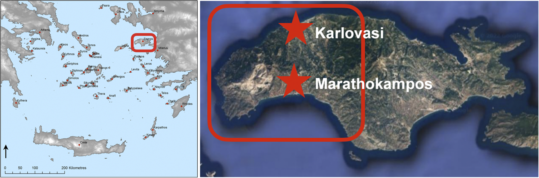
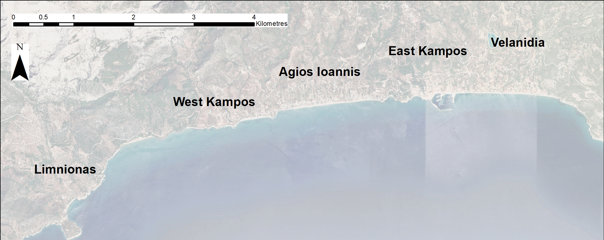
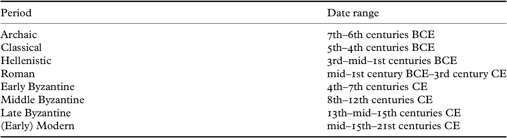
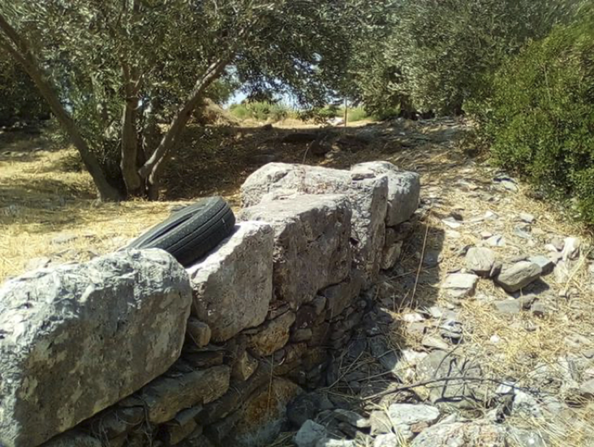
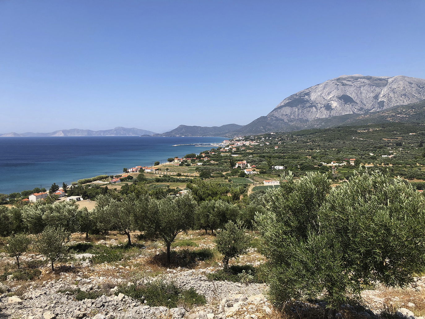
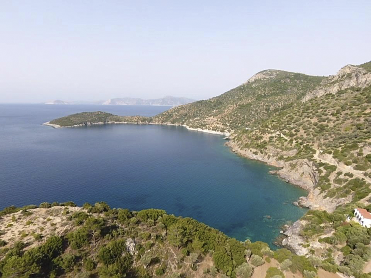
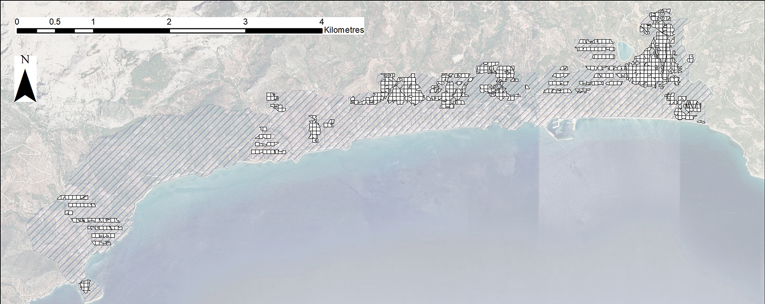
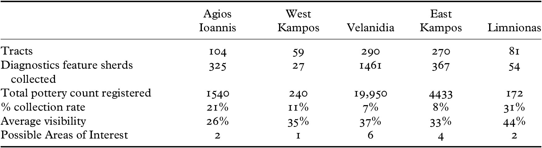
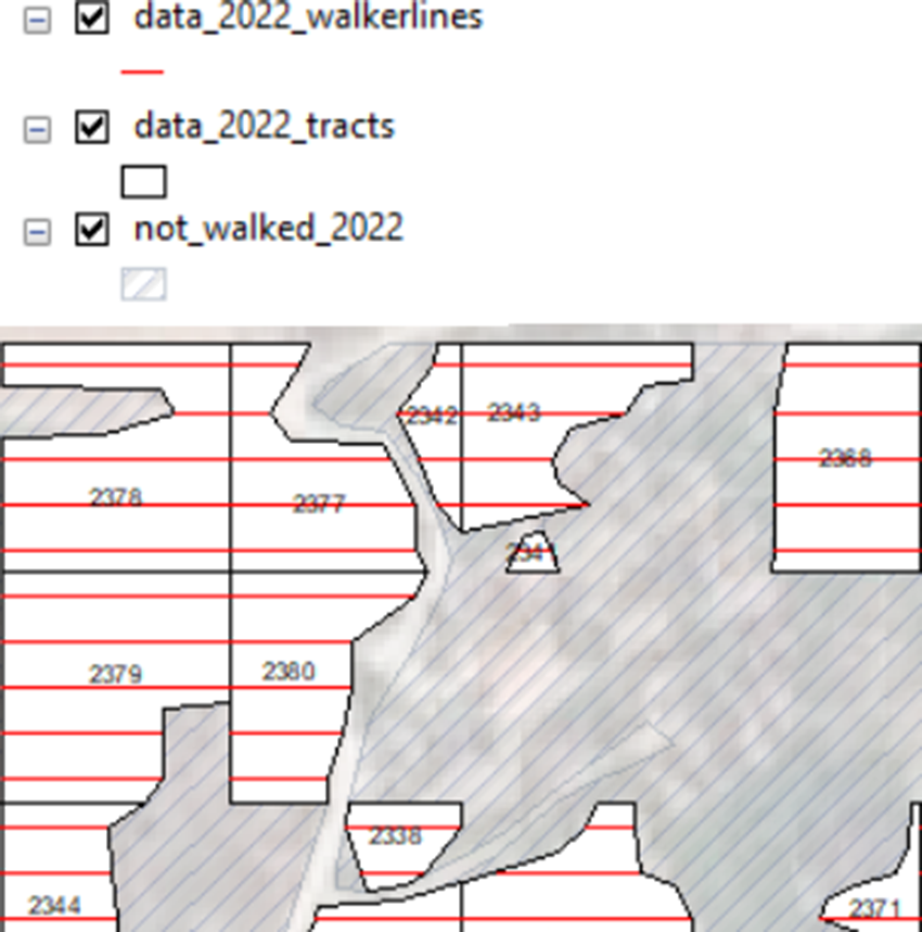
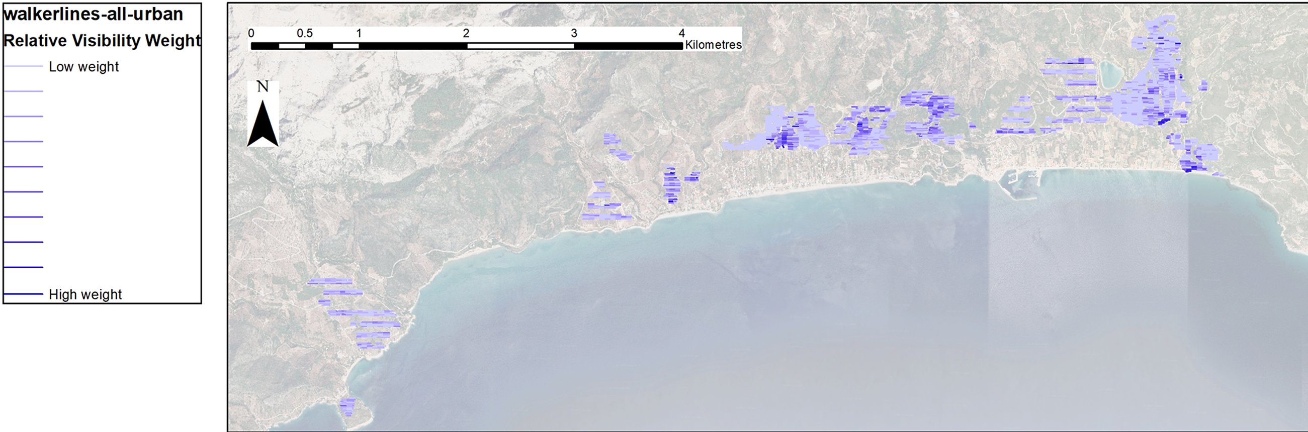
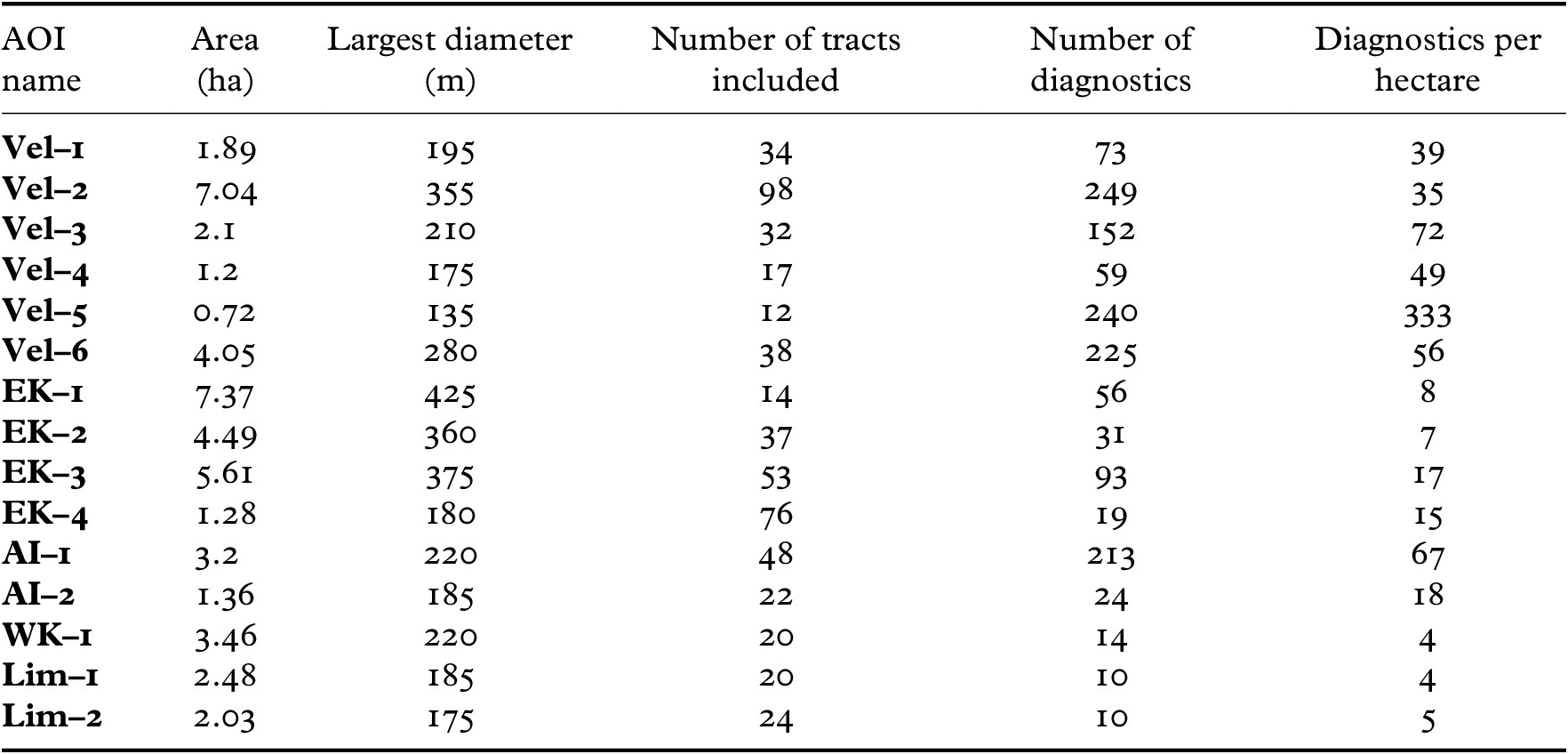
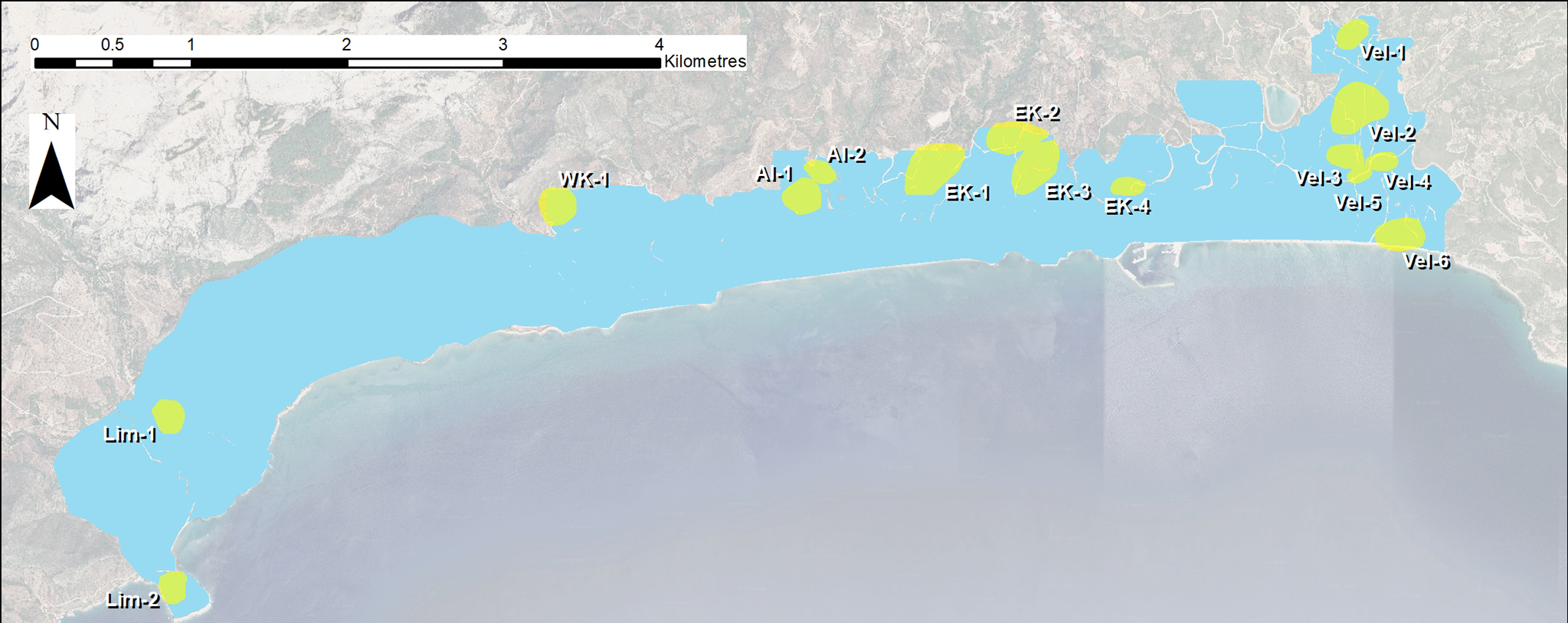
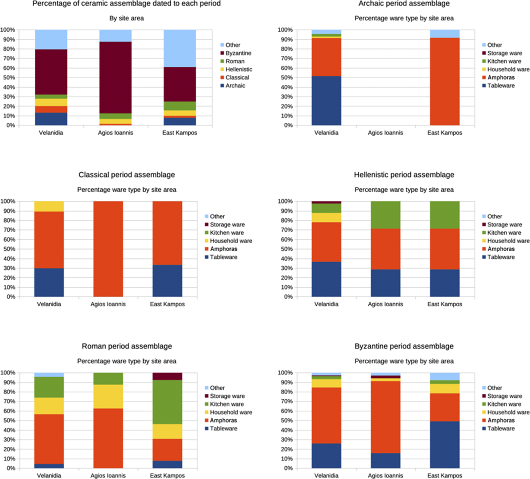
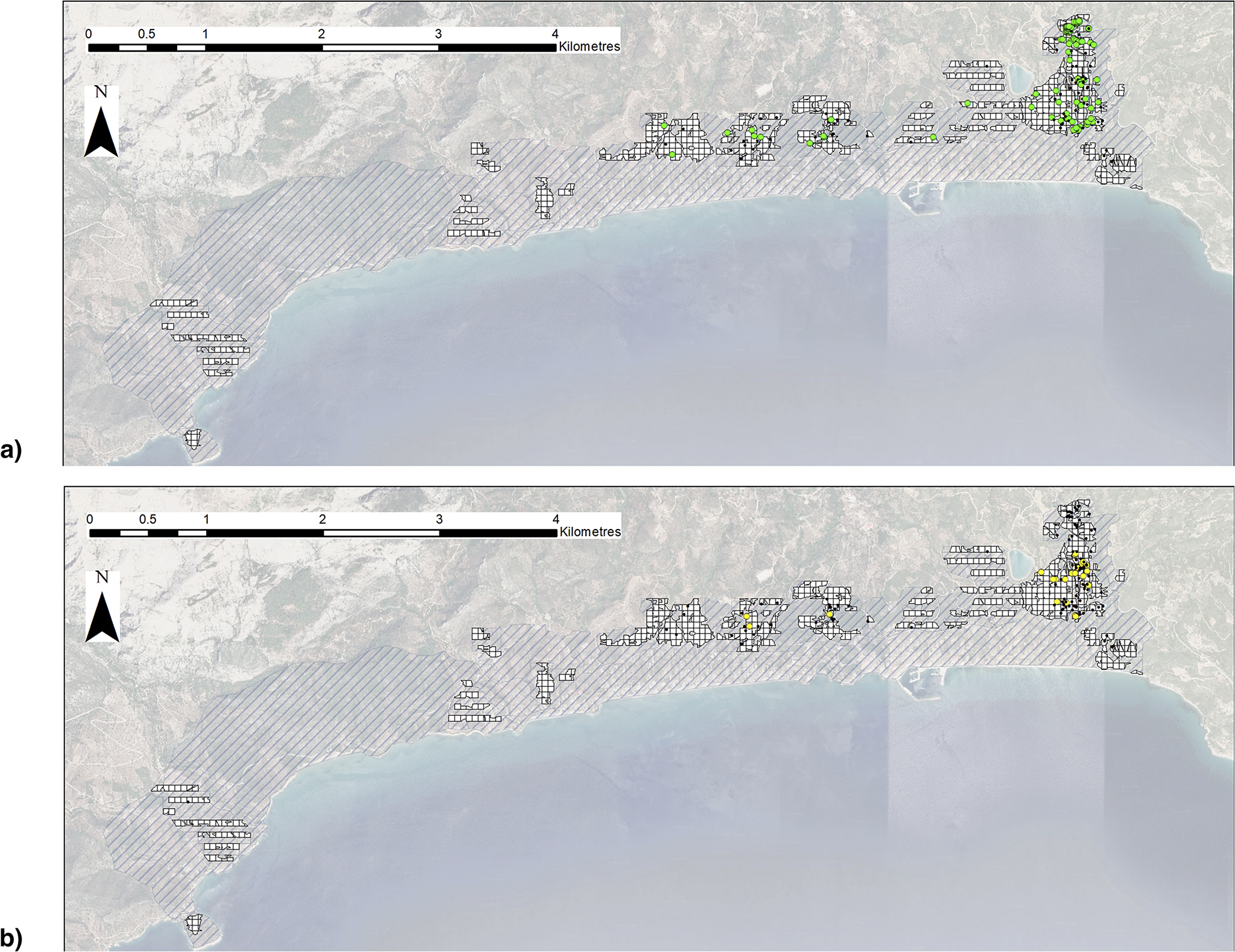
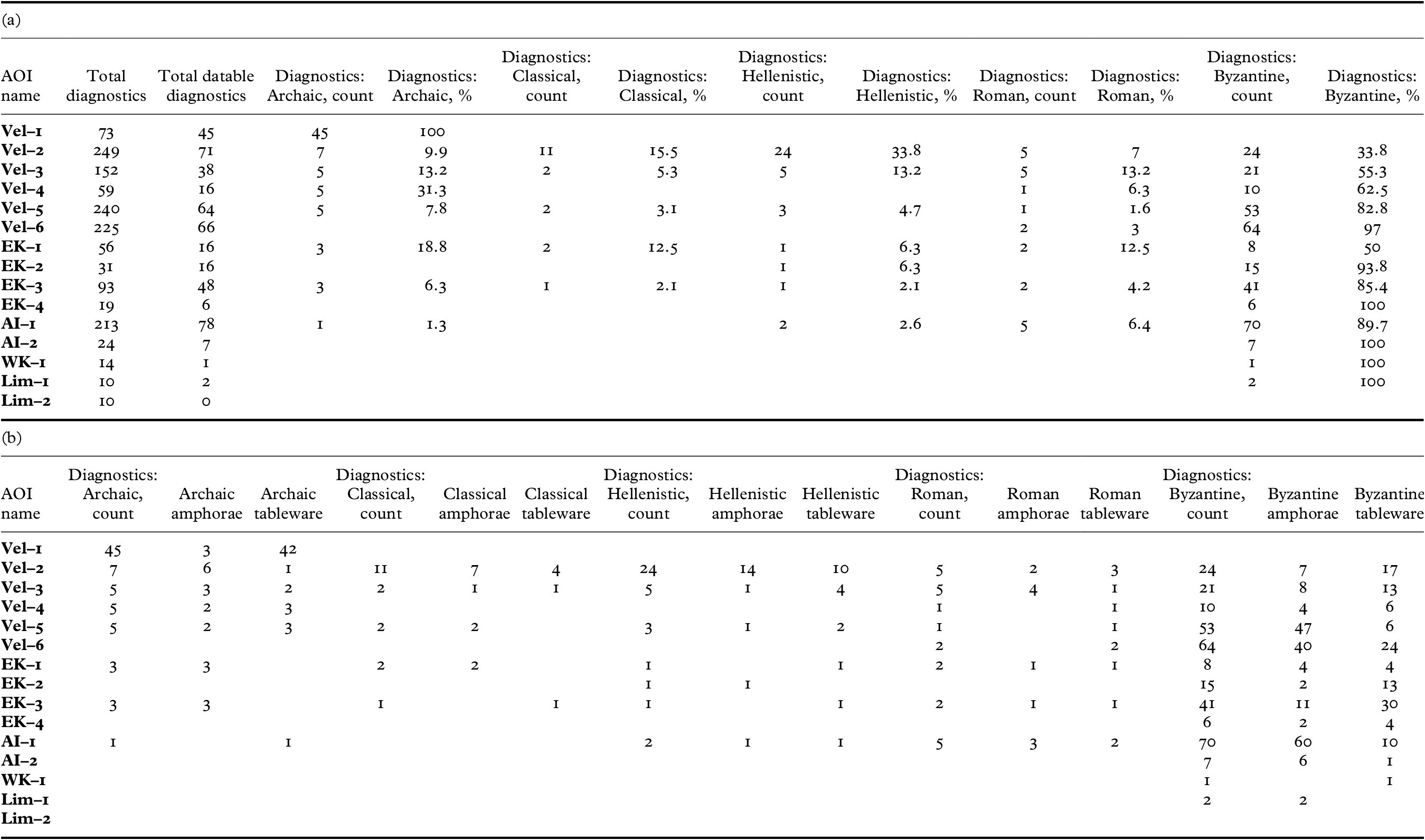
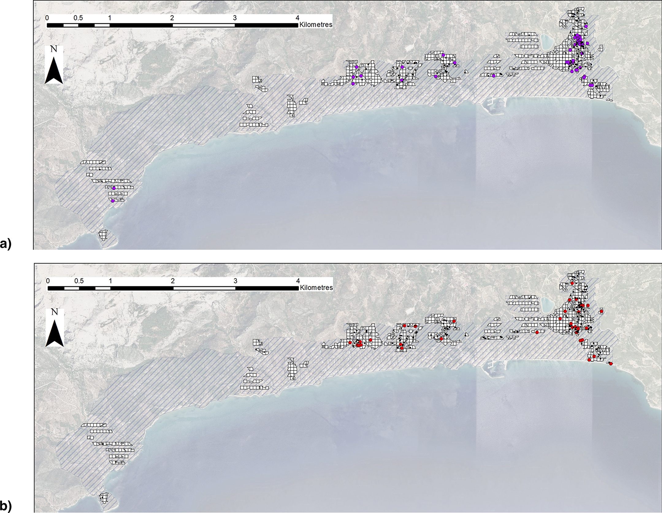
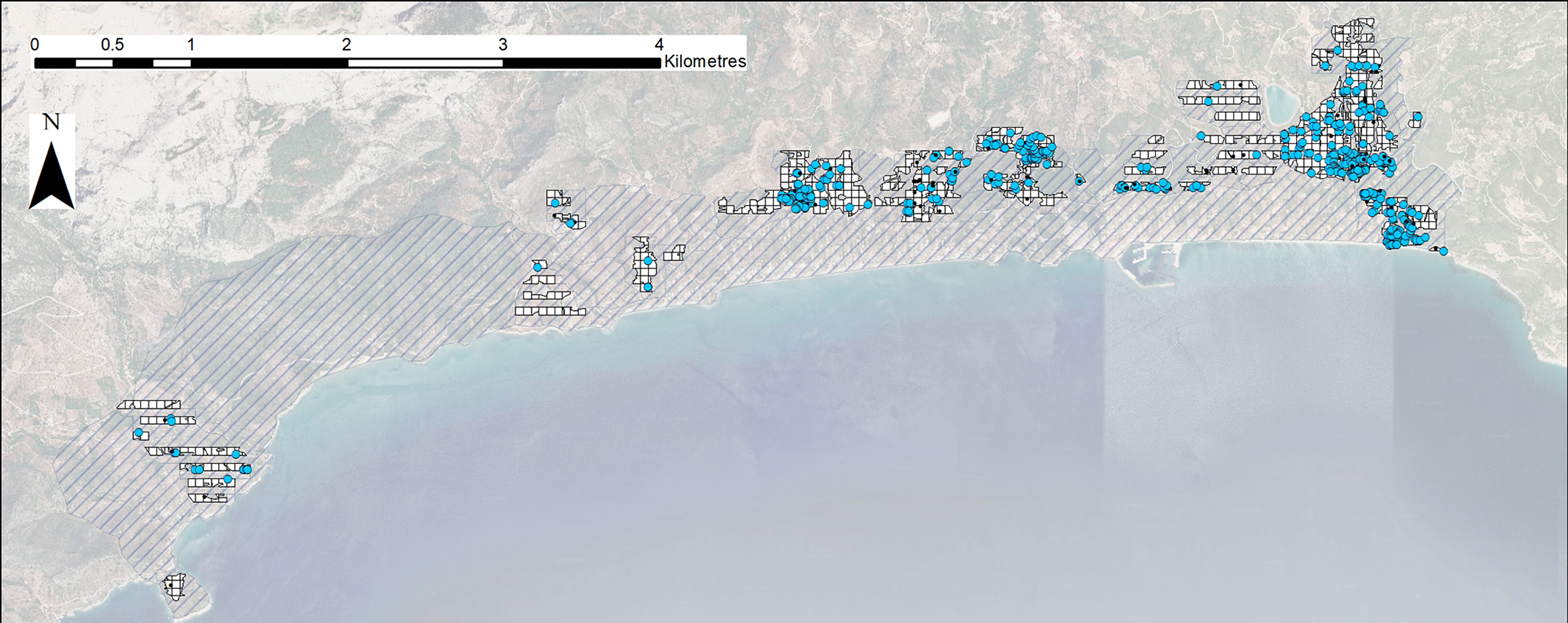
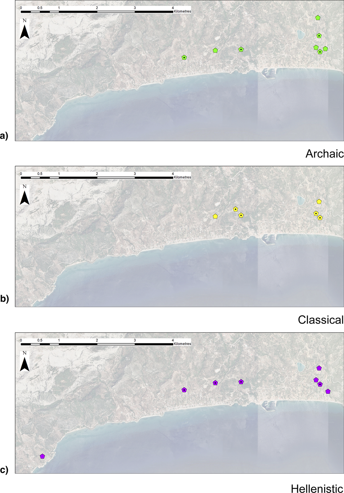
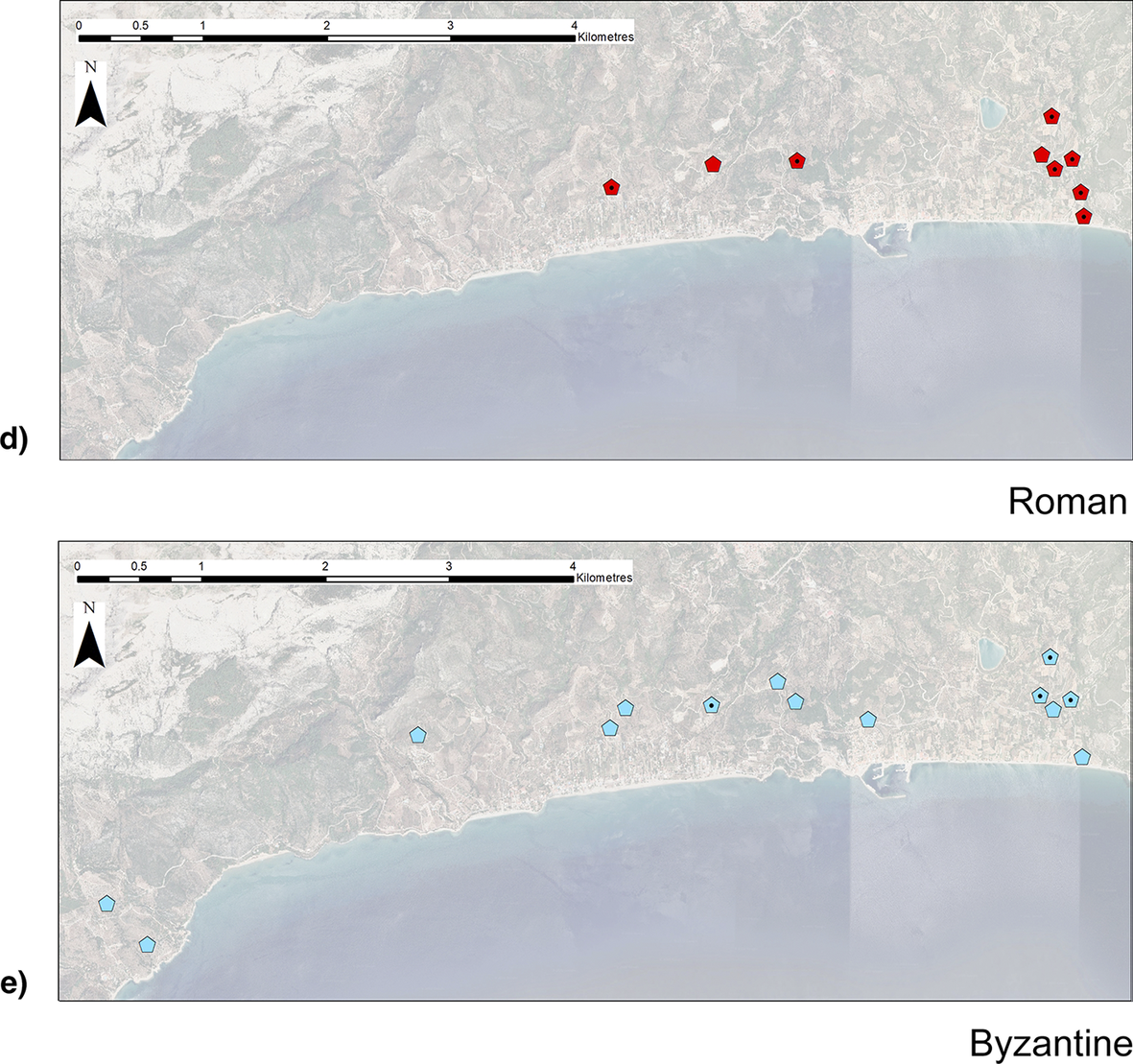
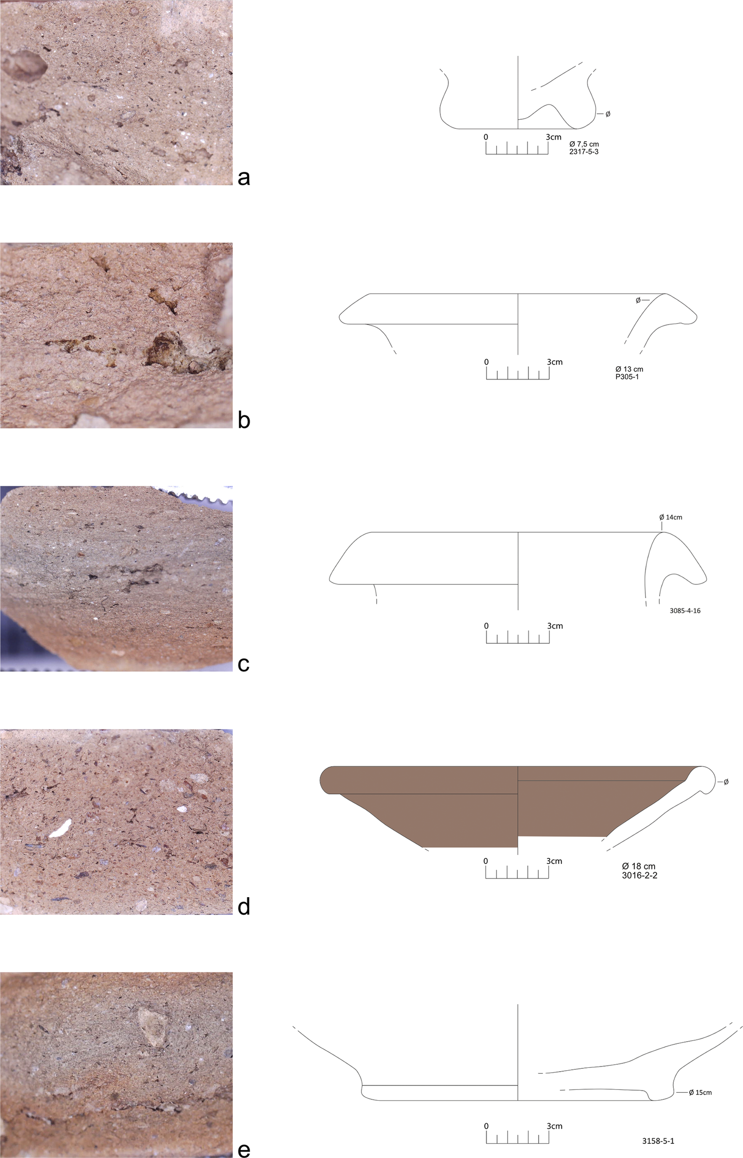
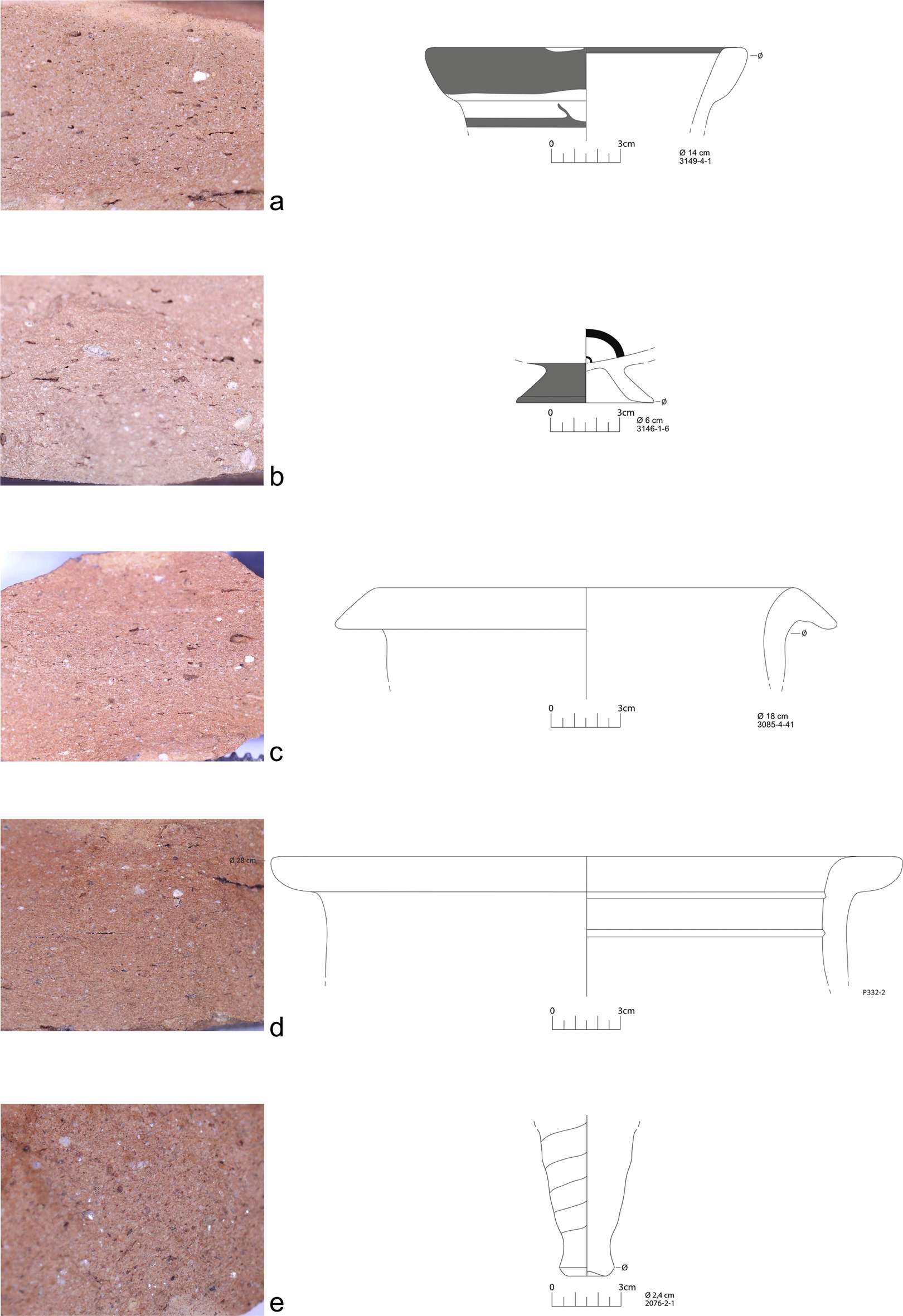
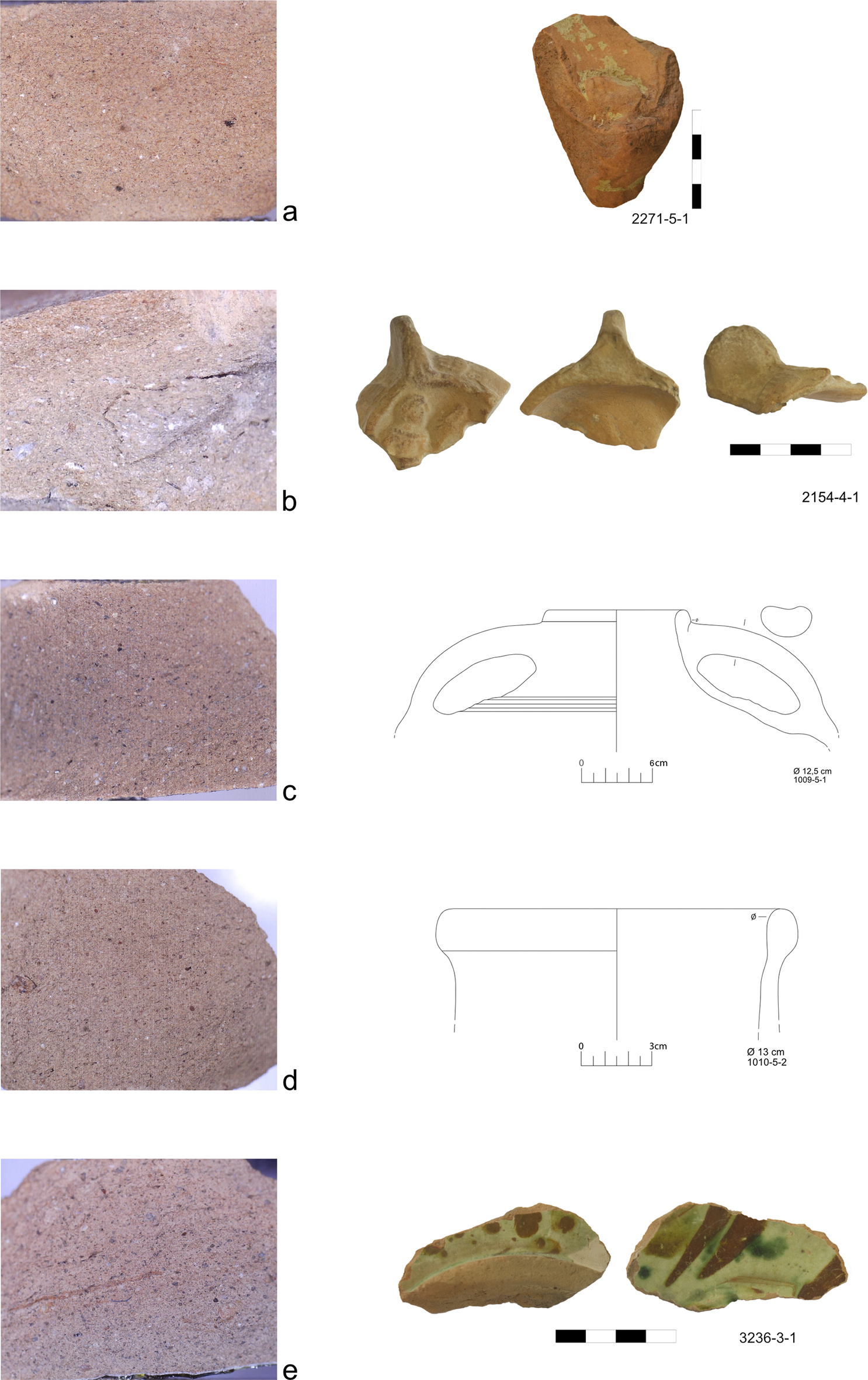
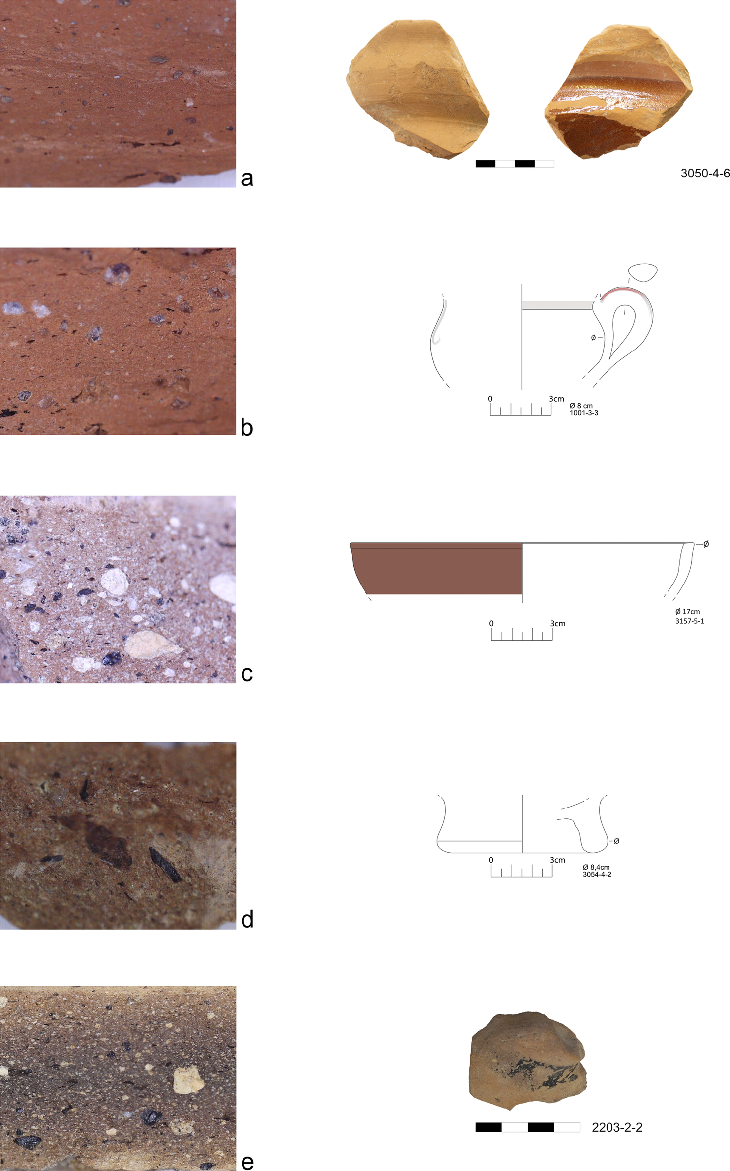
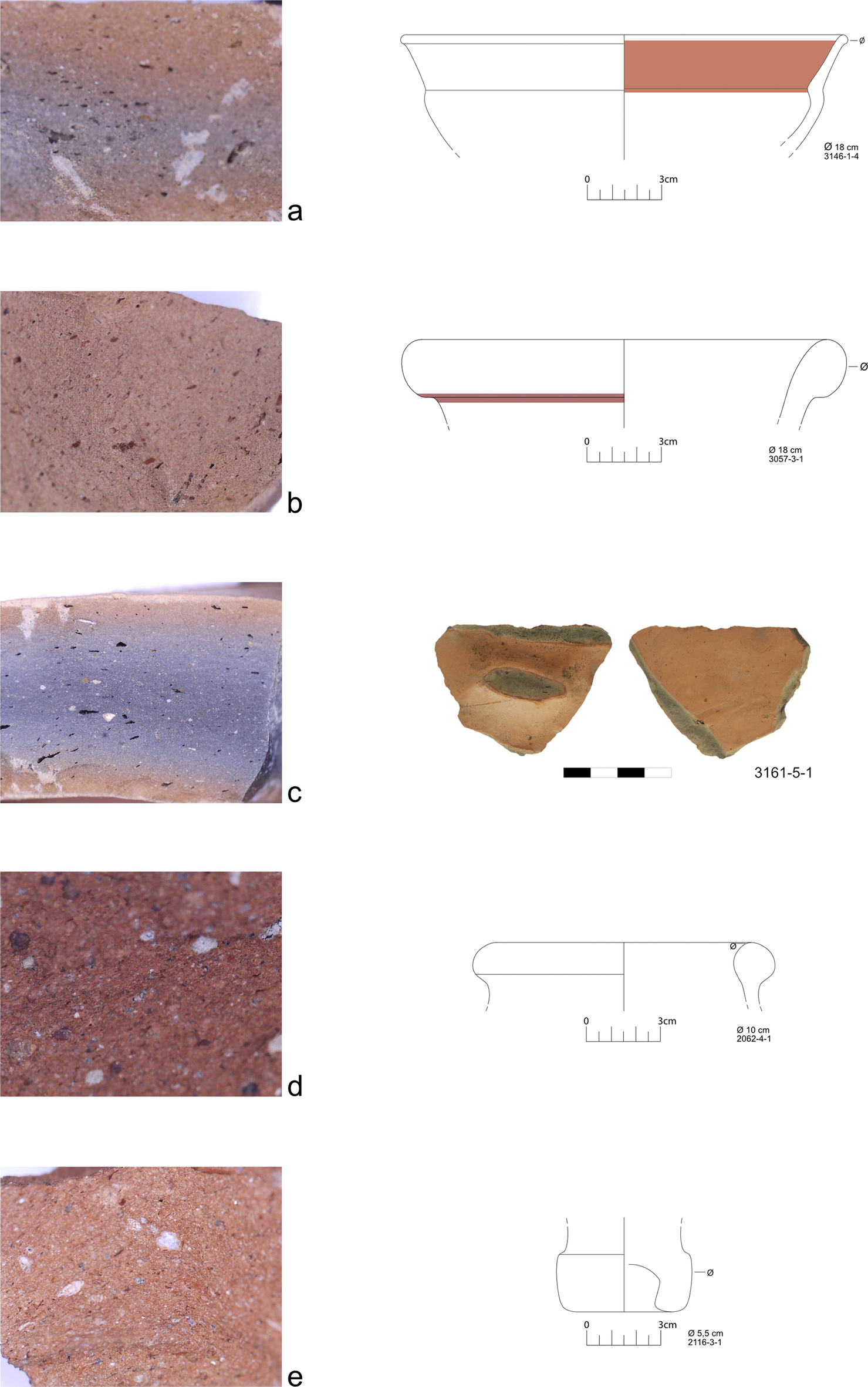
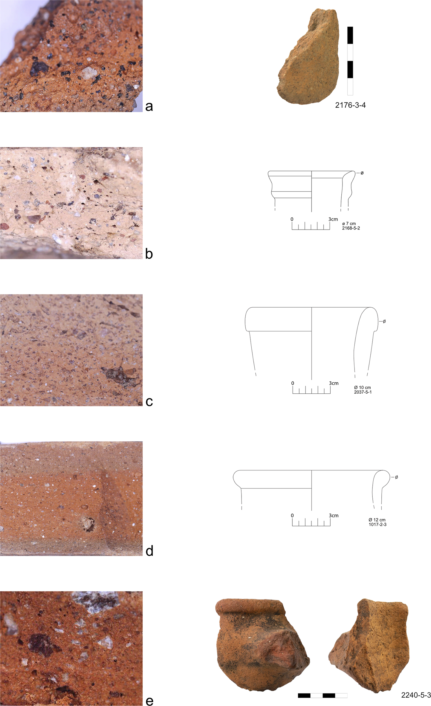
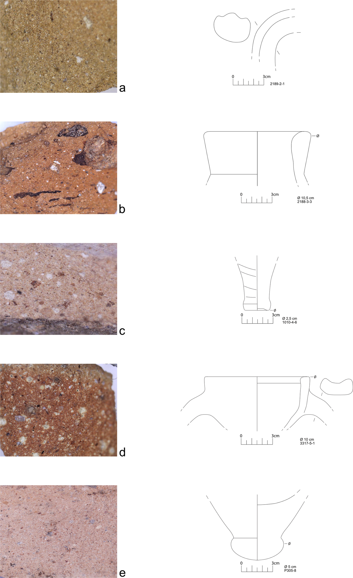

 Open access