

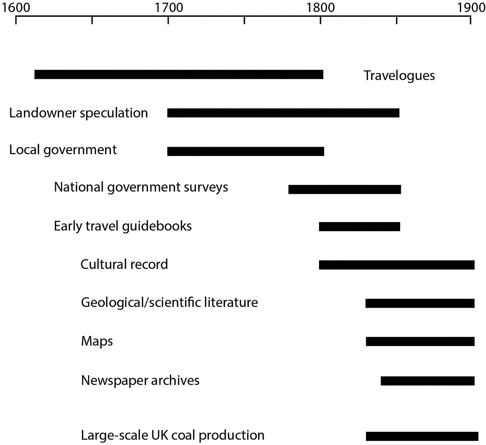
Britain is substantially shaped by its resources of coal, which were exploited over many centuries until recently. The distribution of coal strongly influenced industrialisation and hence the distribution of population, and its extraction still scars the landscape. As in many other countries, almost all of the coal is of Carboniferous age – a consequence of the timing of plant evolution and the fortuitous distribution of continents along tropical latitudes. In other parts of the world, plant-based coals were formed at times post-Carboniferous, and Britain has a representative in the Jurassic Brora Coalfield in northern Scotland. However, in several countries, including China, Korea and Afghanistan, ‘coal’ is exploited from Silurian and older rocks, back into the Precambrian (Wnuk Reference Wnuk2016; Dai et al. Reference Dai, Zheng, Wang, Finkelman, Jiang, Ren, Yan and Zhou2018; Parnell Reference Parnell2022). These resources are not composed of higher plant remains, and are rather marine rocks with high carbon contents, deposited at a time when the deep oceans were widely anoxic. In Britain and Ireland, Ordovician-Silurian (simplified as Silurian hereon, following 19th Century usage) anoxic sediments are represented by the deposits of the Iapetus Ocean. Not surprisingly, when stratigraphy was poorly understood, the Silurian rocks were explored for coal in many areas. The search found highly carbonaceous sediments (up to 5% total organic carbon), which could be enough to engender optimism. The oceans of this age contained abundant algae with a high oil content (Reed et al. Reference Reed, Illich and Horsfield1986; Makled et al. Reference Makled, Farouk, Al-Hadidy, Mohammed and Lawa2021) so the carbonaceous rocks could make a modest fuel. That story is largely overlooked. Here, we bring together evidence from diverse sources (Fig. 1) to tell the story of coal exploration in the Silurian of the Southern Uplands-Down-Longford Terrane (SUDLT) in Scotland and Ireland (Fig. 2).
Range of information sources that contribute to documentation of coal exploration in the SUDLT.
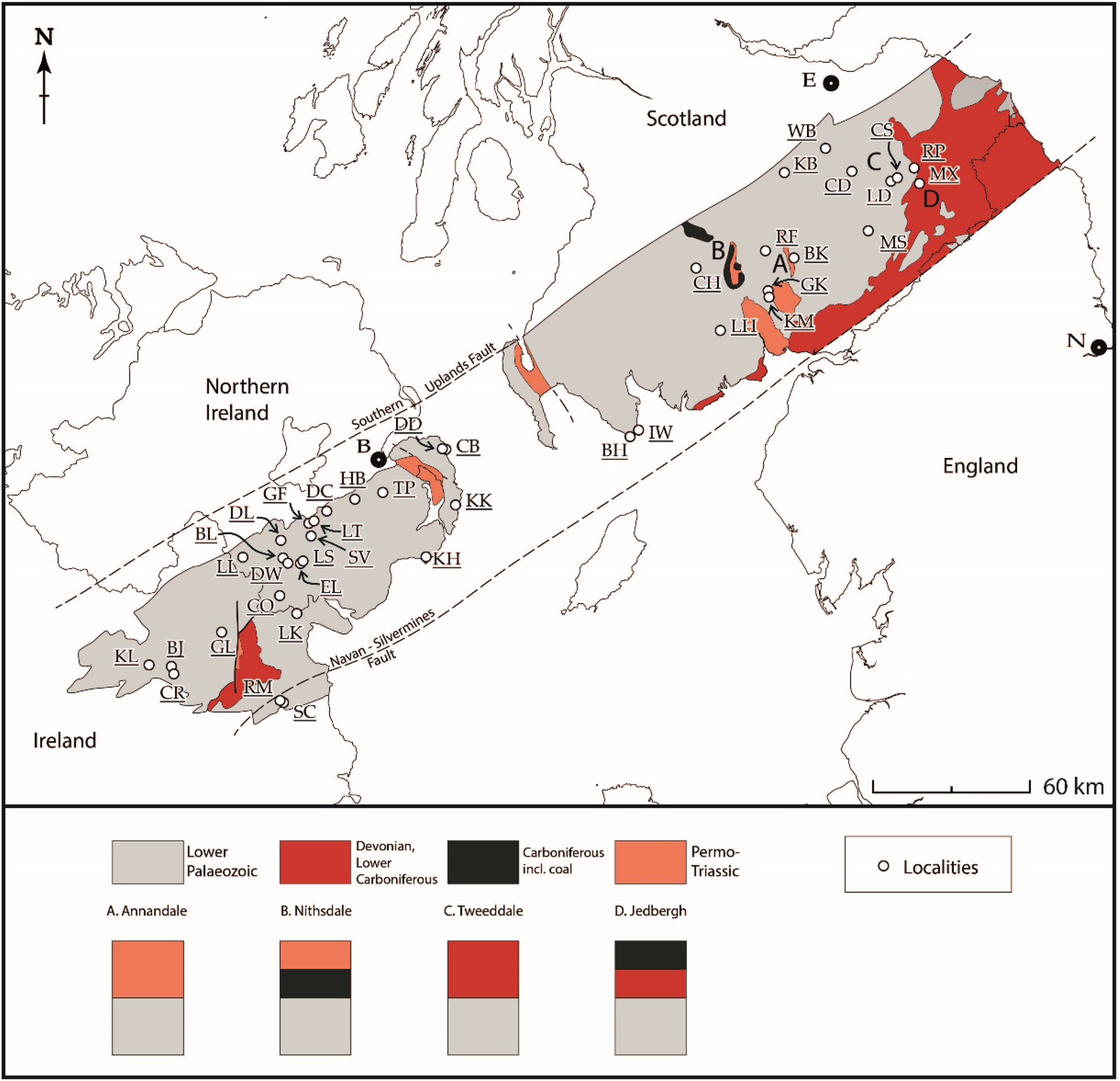
Map of the SUDLT showing locations mentioned in the text and schematic variations in succession of dark units and red beds. Further details in Supplementary Material. Abbreviations: (Scotland) BH = Borrow Head (now Burrow Head); BK = Brekonside; CD = Cadon Bank; CH = Coal Hole; CS = Cauldshiels; GK = Glenkiln; IW = Isle of Whithorn; KB = Kilbucho; KM = Kirkmichael; LD = Lindean; LH = Larghill; MS = Milsington; MX = Maxton; RP = Redpath; RF = Rivox Fell (Coalpit Burn); WB = Windylawsburnfoot; (Ireland) BJ = Ballyjamesduff; BL = Ballylane Lough; CB = Coalpit Bay; CO = Coulter's Bridge; CR = Castlerahan; DC = Donaghcloney; DD = Donaghadee; DL = Drumlack; DW = Drumcrow; EL = Enagh Lough; GF = Gilford; GL = Glasleck; HB = Hillsborough; KH = Killough; KK = Kirkistown; KL = Kilnaleck; LK = Lurgankeel; LL = Lislea Cottage; LS = Lissummon; LT = Lawrencetown; RM = Rathmaiden; SC = Slane Coalpits; SV = Scarva; TP = The Temple; (cities) B = Belfast; E = Edinburgh; N = Newcastle upon Tyne.
1. Geological setting
The variable stratigraphies across the SUDLT help in understanding why exploration could be confused. The full possible stratigraphy is upper red beds (Permo-Triassic), above a section including black coal (Carboniferous), above lower red beds (Devonian-lowest Carboniferous), above a section containing black mudrocks (Silurian). The black mudrocks accumulated with sandstones as an ‘accretionary prism’ at the margins of the non-subducting tectonic plate at a convergent plate boundary (Leggett et al. Reference Leggett, McKerrow and Eales1979; Leggett Reference Leggett1980; Morris et al. Reference Morris, Somerville and MacDermot2003). Four options for local partial stratigraphy in Scotland are shown in Fig. 2. In the western part (e.g., Annandale), the higher red beds (Permo-Triassic) lie directly on the lower black rocks (Silurian). In Nithsdale, the Carboniferous intervenes. In the east (e.g., Tweeddale, Jedburgh), the lower red beds (Devonian) lie on the Silurian, with local overlying Carboniferous. Two potential mistakes are (i) exploration below the Devonian, mistaking it for Permo-Triassic, i.e., confusing the two red bed units; and (ii) exploration below the Permo-Triassic directly into the Silurian, not recognising that the Carboniferous and Devonian are missing. Further, in the Jedburgh area, where thin Carboniferous coal seams occur (Milne Reference Milne1843; New Statistical Account of Scotland 1845c), steep hillsides place both black rocks close together such that accurate geological mapping is required to predict their distribution.
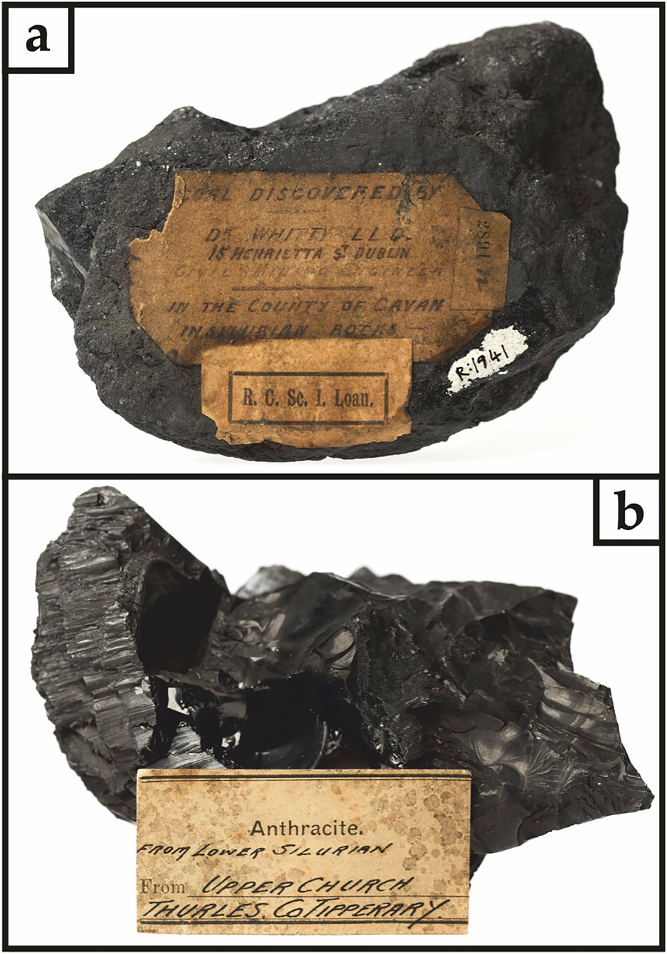
Coal exploration in the SUDLT is focussed on beds of carbonaceous shale, especially the Moffat Shale, which is variably of Ordovician to Silurian (Llandovery) age. Almost all of the shale localities explored for coal are in the Moffat Shale, except those in the southernmost part of the outcrop (e.g., Borrow Head, Slane Coalpits), which may be of slightly younger Silurian age. Repetition of the carbonaceous rocks by thrusting means that outcrops of the Moffat Shale occur at intervals across the structural strike of the SUDLT, separated by successions of turbiditic sandstone (McCurry & Anderson Reference McCurry and Anderson1989; Merriman & Roberts Reference Merriman and Roberts2000; Needham Reference Needham2004; Beamish et al. Reference Beamish, Kimbell, Stone and Anderson2010). The fault-repeated stack of alternating sandstone and carbonaceous shale is oriented with highly inclined dip so that the shale beds occur at intervals in a N-S transect through southern Scotland and the north of Ireland. The pattern of beds repeated by thrusting extends to the western limit of the outcrop in County (Co.) Cavan, where the Moffat Shale is of Silurian age (Morris et al. Reference Morris, Somerville and MacDermot2003). The occurrence and behaviour of carbon in these rocks is described by Parnell et al. (Reference Parnell, Armstrong, Blamey, Boyce, Schito and Muirhead2023). In addition to the shale itself, hydrocarbon generation from the shale yielded solid coal-like matter (‘bitumen’) which must have been the impetus for coal exploration in many cases (Fig. 3). The combination of the oil-prone nature of the carbon in these rocks and its repeated occurrence in an accretionary prism setting made it an understandable target. The carbonaceous matter in the SUDLT Silurian rocks is distinct from that in the younger Carboniferous rocks which include genuine coal deposits. Coal is bedded, contains fossils, and in Scotland and the north of Ireland has a relatively low thermal maturity. In contrast, the bitumen is commonly vein-like, not fossiliferous, and has a relatively high thermal maturity (Schito et al. Reference Schito, Muirhead and Parnell2022). That distinction is evident in the laboratory, and to the experienced geologist, but would not have been obvious to many of the early explorers. The confusion is evident in the use of the term ‘anthracite’, a variety of coal, to describe the carbonaceous matter in the Silurian rocks (Harkness Reference Harkness1851; Whitty Reference Whitty1854).
Samples of bitumen from Silurian deposits in the SUDLT and its SW continuation in Co. Tipperary, mined as coal. (A) Bitumen from Kilnaleck, Co. Cavan, exhibited and described by Dr Whitty, mining engineer Dublin (Whitty Reference Whitty1854, Reference Whitty1855). (B) Bitumen from Upper Church, Co. Tipperary, mined in mid-19th Century (Wynne & Baily Reference Wynne and Baily1860). Samples from collections of National Museum of Ireland (numbers R1941, R1931).
2. Data sources
The sources of information on exploration are diverse, and the categories distinguished below inevitably overlap. They range from the commercial and administrative to the popular and cultural, and of course geological (Fig. 1).
2.1. Travelogues
The earliest accounts of travel through the region, which might include observations of mining, were personal diaries. Some have survived through later transcription.
In Scotland, we have the 1629 ‘Journall into Scotland’ (sic), which refers to coal mining at Milcinton (Milsington), west of Hawick (Lowther et al. Reference Lowther, Fallow and Mauson1894). The location is accurate, within a well-described sequence of places along the journey, but like several other early records the mining is uncorroborated by other evidence and must be considered doubtful.
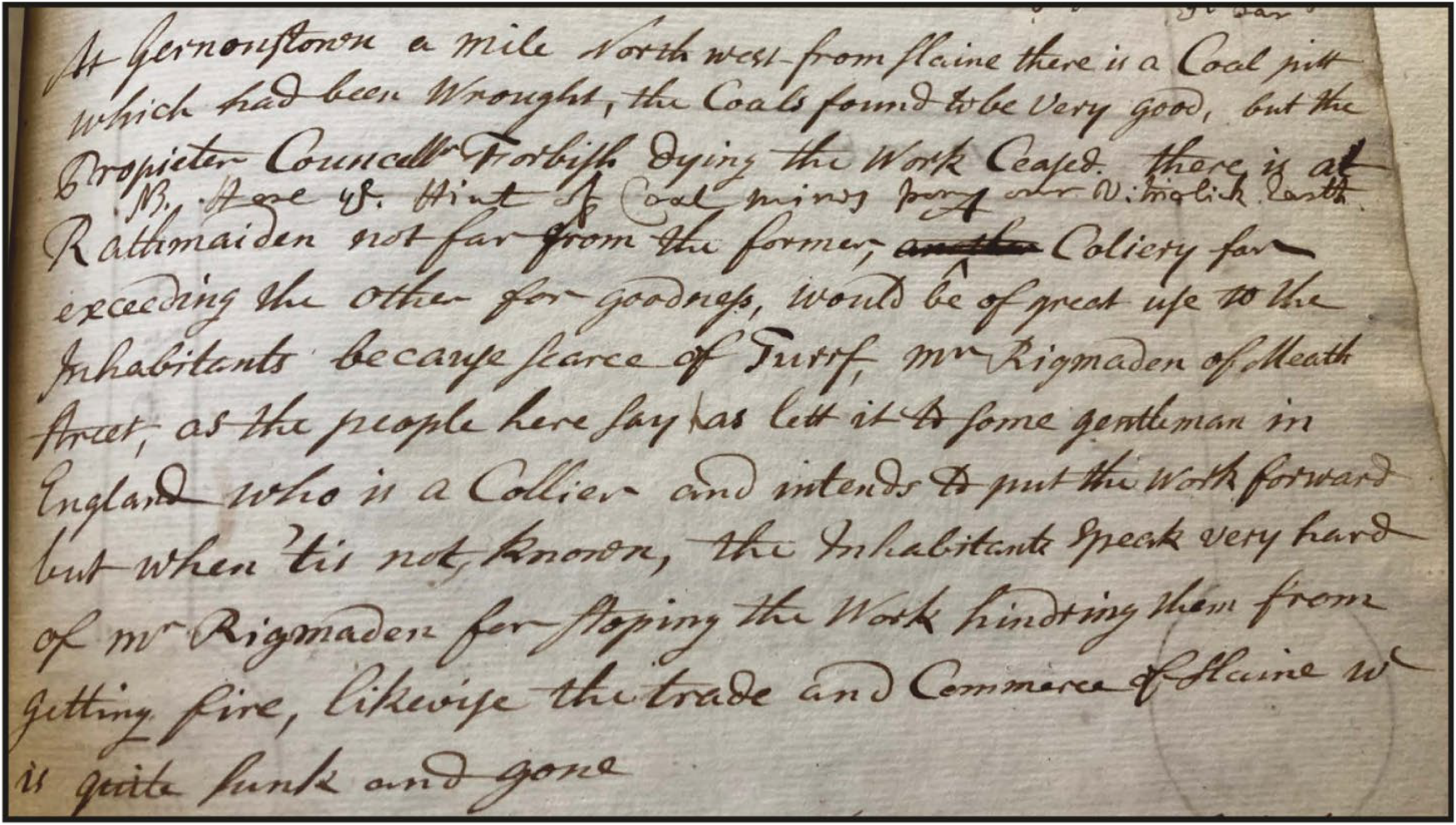
In Ireland, the journal of botanist Isaac Butler is incompletely transcribed, but is preserved at the Armagh Robinson Library, Armagh. The handwritten text (Fig. 4) tells us of mining coal in the region of Silurian rocks north of Slane, Co. Meath (Butler Reference Butler1744). The travels of Richard Pococke, Archdeacon of Dublin and later Bishop of Meath, in both Ireland and Scotland, are well documented. Pococke visited the coal working at Slane, but it was not producing in 1752 (Pococke Reference Pococke1752). Pococke's Journey through County Down in 1760 reported coal mining at Donaghadee. A commentary on this account by Woods (Reference Woods1985) doubted the record, but Pococke's observations in the region were otherwise quite accurate. In Scotland, Pococke observed diggings for coal at the Isle of Whithorn (Kemp Reference Kemp1889). Another early account of Co. Down recorded a shaft sunk for coal at Killough (Smith & Harris Reference Smith and Harris1744).
Extract from the journal of Isaac Butler (Reference Butler1744), referring to coal mines in Silurian rocks at Gernonstown and Rathmaiden, north of Slane, Co. Meath. Transcript in Supplementary Material. Image courtesy of Armagh Robinson Library, Armagh.
The next phase of travel literature is that of early guidebooks, intended to take the traveller to places of interest. These include The Scientific Tourist Through Ireland (Walford Reference Walford1818) and A Topographical Dictionary of Ireland (Lewis Reference Lewis1837). The guidebooks mostly repeat information that had appeared elsewhere, but they do suggest that some mining localities were sufficiently established to be common knowledge. Lewis (Reference Lewis1837) is, however, the sole source of ‘coal’ records at Castlerahan, Co. Cavan; Drumlack, Co. Armagh; and Gilford, Co. Down.
2.2. Local government and the church
In the 18th Century, government could see the value in promoting coal exploration, especially at a local scale, and had the resources to do it.
The Slane story continues with a 1747 petition from four local men to the House of Commons in Dublin for money to develop collieries at nearby Rathmaiden, Co. Meath (House of Commons 1763a). The parliamentary records show that £500 was awarded, remarkably just ten days later, to enable ‘furnishing Dublin … with large quantities of coals’ (House of Commons 1763b), albeit on condition of scrutiny by a group of experts (Fig. 5). Alderman Bevan sank a shaft at Ballyjamesduff, Co. Cavan (Coote Reference Coote1802), which may have been in an official capacity.

Shortly after the Slane investment, in 1755, the town council in Peebles offered land, finance and labour to explore for coal in the Silurian rocks at Windylawsburnfoot (Buchan Reference Buchan1925). In 1759 they also paid for timber to line a coal exploration shaft (Chambers Reference Chambers1864).
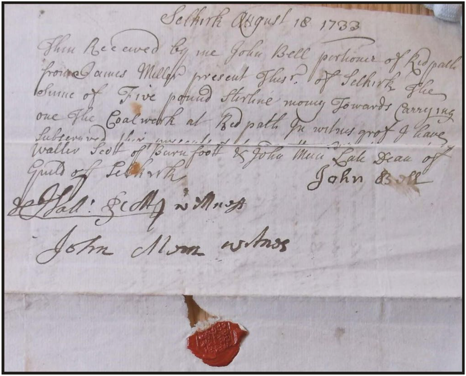
The records of the Selkirk council indicate a prolonged interest in the prospects of coal at Lindean. They agreed to fund a workman to help exploration in 1707; sought advice from the provost of Sanquhar, where Carboniferous coal was mined, in 1718; and resolved to arrange finance to support further coal exploration in 1816 (Craig-Brown Reference Craig-Brown1886). Further evidence for the exploration for coal in the region is fortuitously preserved in a receipt for ‘coalwork at Redpath’ (Fig. 6), witnessed by a Dean of Guild of Selkirk (Bell Reference Bell1733).
Receipt, John Bell of Redpath, to burgh treasurer, for coal work. From Walter Mason papers, burgh accounts WM/7/313, Walter Mason Archive (Scottish Borders Archives GB1097 WM/7/313). Transcript in Supplementary Material. (Border Collections Online, Selkirk; https://www.calmview.eu/HUBCAT/CalmView/Record.aspx?src=CalmView.Catalog&id=WM%2f7%2f313)
The church also played a role in Selkirkshire and Roxburghshire. In the 18th Century, where exploration at Redpath and Lindean had been sufficiently promising to suggest that coal could be found, collections were made at churches to fund local exploration. As an incentive, parishes were promised a 200% return on any investment that resulted in a discovery (Elliot Reference Elliot2012).
2.3. Maps
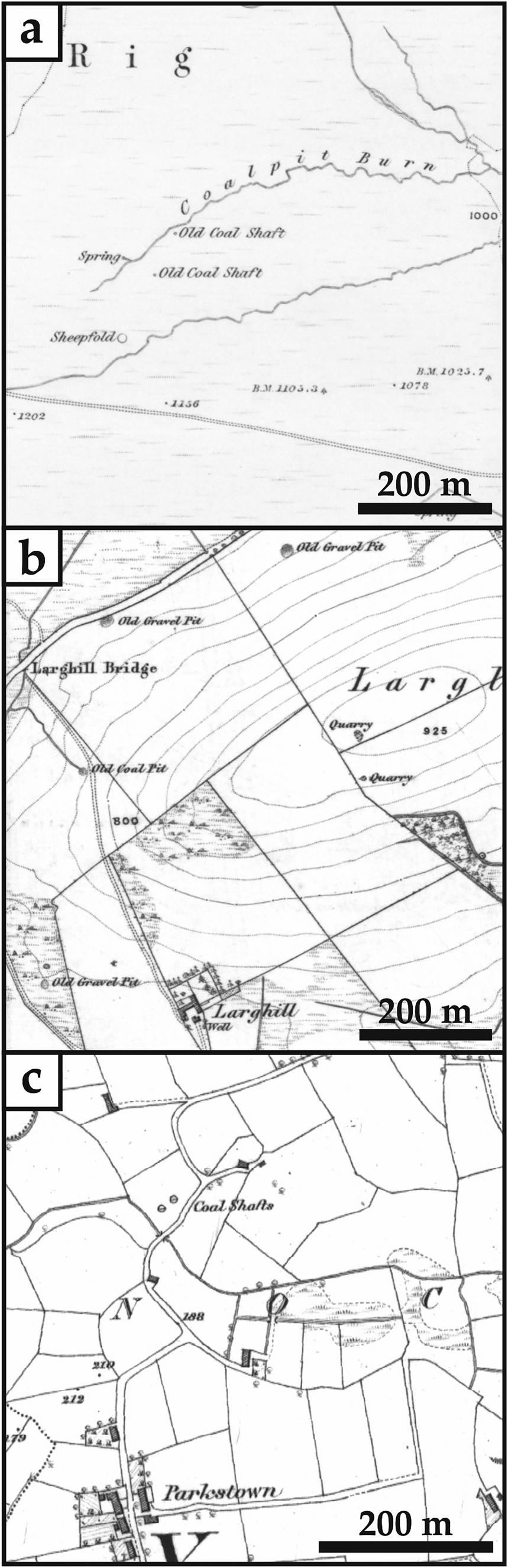
The earliest six-inch to the mile Ordnance Survey (OS) maps, published in the 1840s, record the precise sites of coal shafts (Fig. 7), including sites about which little else is known, such as Larghill, Dumfriesshire, Coalpit Burn, Dumfriesshire; and Lawrencetown, Co. Down. These records are supported by OS namebooks, which explain the origin of place names on the earliest OS maps, such as Coalpit Burn and the Coal Hole in Dumfriesshire, which are named after old coal shafts. The namebooks are original, handwritten, contemporaneous records.
Extracts from Ordnance Survey maps (six-inch to the mile) showing locations of coal shafts in Silurian rocks. (A) Coalpit Burn, Dumfriesshire (Sheet 15, 1st edition, survey 1857). (B) Larghill, Kirkcudbrightshire (Sheet 26, 1st edition, survey 1854). (C) Lawrencetown (Laurencetown), Co. Down (Sheet 26, 2nd edition, survey 1860). Scottish maps reproduced with the permission of the National Library of Scotland. Lawrencetown map contains OSNI information licensed under the terms of the Open Government Licence v3.0.
Names on maps alone may be all that survives. Probably the most famous site in this survey is Coalpit Bay, Co. Down, which has featured in many publications on graptolites and their stratigraphy. The site of the ‘pit’ is known (Mitchell Reference Mitchell2004), but we are not aware of any record of exploration. Curiously, it is the most recently documented, in 1870, when the origin of coal was well established.
2.4. Geological literature
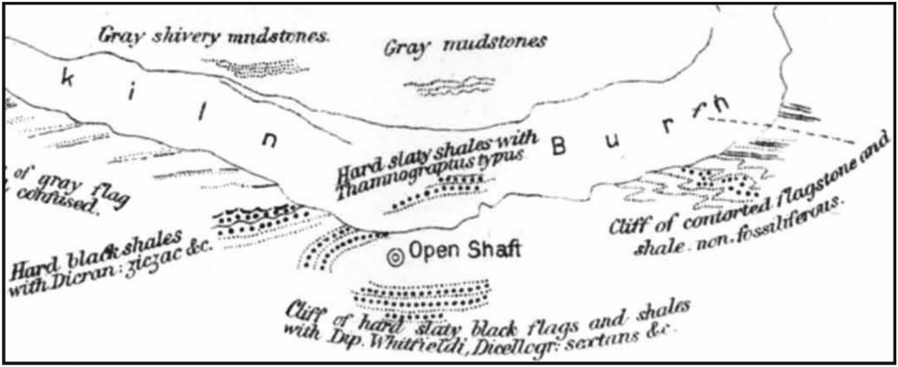
The Geological Surveys based in Edinburgh (now British Geological Survey), Dublin (now Geological Survey of Ireland) and latterly Belfast (Geological Survey of Northern Ireland) have archives where local details are preserved. Memoirs published to accompany one-inch to the mile geological maps in the 19th Century contain records of coal exploration in the Silurian rocks, especially in Ireland. Several localities in Co. Armagh (Ballylane Lough, Enagh Lough, Lissummon, Coulter's Bridge, Drumcrow, Lislea Cottage) and Co. Down (Donaghcloney Bridge) are known solely from the memoirs (Egan Reference Egan1872, Reference Egan1877). In Scotland, the equivalent observations were recorded in papers in scientific journals. Several scientists studied the structure of the Southern Uplands of Scotland, making use of an abundance of fossil localities. Papers by Jameson (Reference Jameson1840), Nicol (Reference Nicol1850), Harkness (Reference Harkness1851) and Lapworth (Reference Lapworth1870, Reference Lapworth1872, Reference Lapworth1878) all incidentally recorded attempts to find coal (Fig. 8). These four authors were to become, respectively, Regius Professor of Natural History at the University of Edinburgh, Professor of Natural History at the University of Aberdeen, Professor of Geology at Queen's College, Cork and Professor of Geology at the University of Birmingham. The Southern Uplands were clearly a good training ground.
Extract from Lapworth (Reference Lapworth1878), showing map of Glenkiln Burn where coal shaft was sunk in an exposure of Silurian black shales.
2.5. Landowners
In the 18th and early 19th Centuries, (titled) landowners were responsible for many mining trials. The trials would usually be beyond the resources of individual farmers, so finance was needed from wealthy landowners, or by local subscription or government. Thus, shafts were sunk or trenching made for coal in the Silurian rocks by the Earl of Traquair at Cadon Bank, Peeblesshire; the Earl of Stair at Stranraer, Wigtownshire; the Marquis of Downshire at Hillsborough, Co. Down; and Lord Cunningham at Slane, Co. Meath.
These men could afford speculative exploration, regardless of geological sense, and in some cases their actions may have been philanthropic, by generating employment (Cowman Reference Cowman2001). The situation was complicated by the practice of deliberately not exploiting a possible coal prospect, or even buying up land to prevent exploitation, in case it gave rise to competition with a landowner's existing assets elsewhere. In Ireland and rural Scotland, a landowner might fear that new local coal would be less expensive to the buyer, and so less profitable, than the coal he was already selling from his mines in England. Suggestions that Lord Londonderry was guilty of suppressing coal deposits in Co. Down for this reason were fully refuted (Dundee Advertiser 1892). Local rumour held that the Marquis Conyngham (sic) had been influenced by an English syndicate not to work the Slane coal mine, and that ‘the railway magnates were subsidised not to construct railways to Irish coal mines so as to hinder their development’ (Drogheda Argus and Leinster Journal 1918). Such practices might have been induced by bribery, as was assumed by the people of Peebles, ‘by certain Mid-Lothian coal proprietors’ (Chambers Reference Chambers1864). Similarly, Edinburgh solicitors Hughes and Milne wrote to Peter Rodger in Selkirk asking permission on behalf of ‘a person accustomed to coalpits to reopen an old coal shaft which was sunk on Lindean … His story being that the conductor of the operation was bribed by the Midlothian proprietor to abandon the work’ (Hughes and Milne 1844). The Duke of Buccleuch, whose coal mining investments in Scotland were extensive, was presumed to have bought up and shelved mines in the Selkirk-Melrose district (Hunter Reference Hunter1867).
Landowners commissioned surveys by men who had some insight into where coal was possible and where not. A letter preserved in the archives of the Dumfriesshire and Galloway Natural History and Antiquarian Society reports a survey in the neighbourhood of Moffat for the Earl of Hopetoun (Taylor Reference Taylor1791). Taylor had a clear understanding of regional stratigraphy, and the need to search for coal between the ‘schistus’ (Silurian) and red sandstone (Permian). While making it clear that the ‘dark schistus’ has ‘no affinity to coal’, he tells us where trials for coal in the Silurian had been made previously, in the Birnock Water and at Breckonside.
2.6. Statistical accounts and economic surveys
Local history is greatly supported by the Statistical Account of Scotland, which was published in the 1780s/1790s, followed by a New Statistical Account in the 1830s/1840s. The economics of individual parishes were described, mostly by local clergy, and in some cases are the only known record of exploring for coal. For example, in Peeblesshire, ‘attempts to find coal … have not as yet been successful’ in Kilbucho (Statistical Account of Scotland 1792) and at Burrow Head, Wigtownshire, ‘trial has been repeatedly made for coal’ (New Statistical Account of Scotland 1845a).
In Ireland, Statistical Surveys were published for individual counties in 1801–1804 (Coote Reference Coote1802, Reference Coote1804; Thompson Reference Thompson1802) and included some specifics of coal exploration. In Co. Cavan, at Glasleck, near Ballyjamesduff, a deposit in the Silurian was described by Coote (Reference Coote1802): ‘There cannot be any coal mine more easily worked; at present one man with a crow-iron and spade could raise above a ton weight daily’.
At about the same time, the Dublin Society commissioned a survey of mineral prospects, organised by county, but of very variable detail. They employed an ‘itinerant mineralogist’, Donald Stewart (Stewart Reference Stewart1799), who recorded a lot of local information. In Co. Down, Stewart learned about ‘coal’ in a drain cut at the old castle at Kirkistown, and that ‘Messrs Reilly and Fify (sic) intend to make a trial for coal’ at Scarvagh (Scarva).
In Scotland, the prospects in the Silurian of Roxburghshire drew the attention of John Buddle, an engineer based in NE England whose popular sobriquet was ‘The King of the Coal Trade’. Buddle published ‘Search for Coal in a Part of the Counties of Roxburgh and Berwickshire, in July 1806’, which reached a remarkable nine editions (Buddle Reference Buddle1807). His reports of coal are from localities in the Carboniferous, but he also described the exploration of localities in the Silurian. Buddle (Reference Buddle1807) and Jameson (Reference Jameson1805) between them discuss the prospects of exploring for coal beneath red sandstone, which in the south of Scotland could mean penetrating the Old Red Sandstone (Devonian) into the Silurian, or the New Red Sandstone (Permian) into the Carboniferous, with very different results. A further possibility involved Carboniferous missing due to pre-Permian erosion so that New Red Sandstone could be penetrated directly into the Silurian. The experiences of the two men in the New Red Sandstone of Dumfriesshire (Jameson) and Old Red Sandstone of Roxburghshire (Buddle) gave them different viewpoints, but they did seem to appreciate the distinction between the two red sandstones.
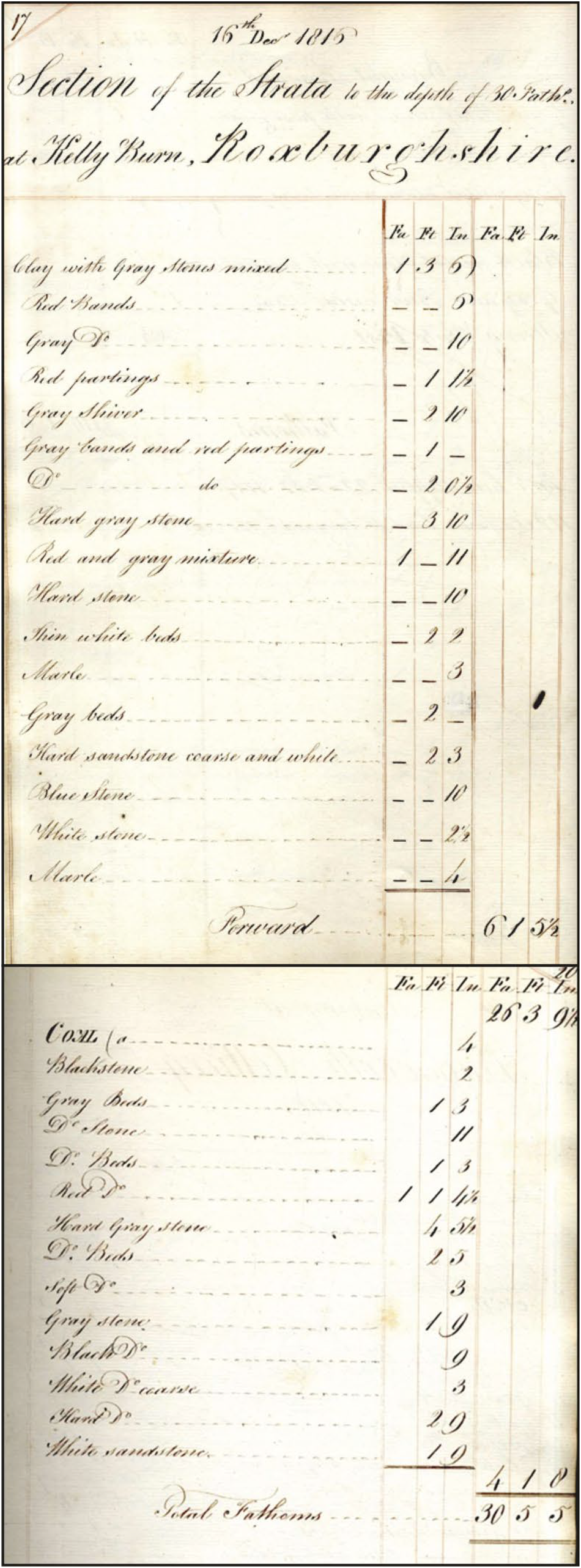
Buddle's reputation in the region drew a query from Hugh Scott (cousin of Sir Walter Scott) about the prospects of Lindean and Kelly Burn, Maxton. The 1816 query, and Buddle's 1817 reply which confirmed his view that the Silurian was unproductive for coal, are held in the National Coal Board Archive, Durham County Record Office (Buddle Reference Buddle1817a). Another archive of Buddle's correspondence, at the Common Room of the Great North, Newcastle upon Tyne (Buddle Reference Buddle1817b), preserves a log of the boring at Kelly Burn (Fig. 9), which refers to small amounts of coal in the section. The Kelly Burn locality was the subject of repeated speculation (Scott Reference Scott1826; Milne Reference Milne1843; Jedburgh Gazette 1912).
Extracts from a log of a boring for coal at Kelly Burn. Document held at the Common Room of the Great North, Newcastle upon Tyne (Buddle Reference Buddle1817b). The extracts show uppermost and lowermost parts of the log, including occurrence of ‘coal’ in the lowest part. However, a letter from John Buddle (‘King of Coal’) to Hugh Scott, 11 January 1817, concluded from the log that no coal would be found there (Buddle Reference Buddle1817a). Letter held at National Coal Board Archive, Durham County Record Office.
2.7. Newspaper archives
Newspapers include two types of reference to coal exploration: advertisements and articles considered to be in the public interest.
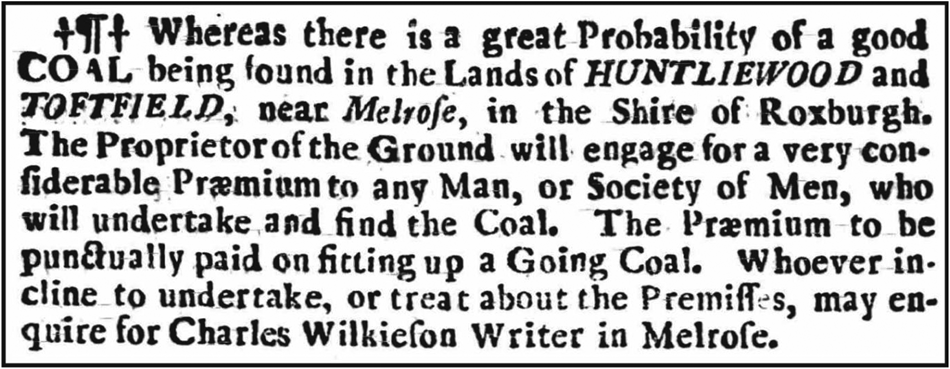
Advertisements relevant to the Silurian include a call to explore for coal (e.g., Caledonian Mercury 1746; Newcastle Courant 1746; eight weeks after the Battle of Culloden) (Fig. 10), a call to manage the development of a new deposit (e.g., at Kilnaleck; General Advertiser for Dublin 1854) and the sale of land which includes a coal deposit (e.g., at Scarva; Dublin Evening Packet 1842) or would be used in the exploitation of a deposit (e.g., at Kilnaleck; The Advocate 1854) (Fig. 11). In the latter example, a property sale near the proposed coal mine highlighted potential income from channelling of the mine wastewater to nearby Corglass Lough, while also praising the lough fishing.
Advertisement in the Caledonian Mercury, 19 June 1746, for workers to explore for coal in Silurian rocks near Melrose.
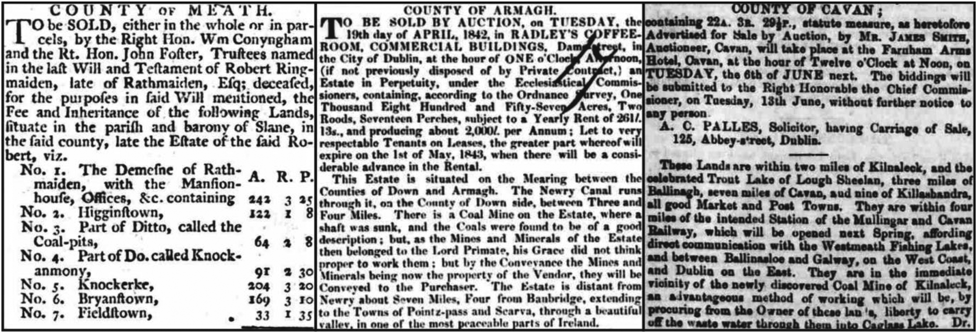
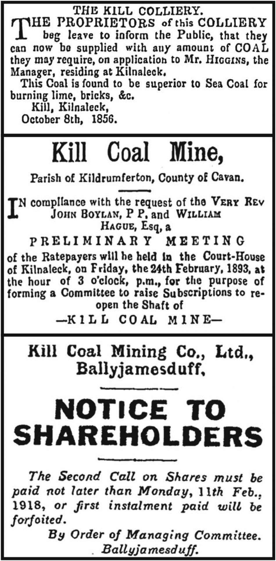
Newspaper advertisements for sales of land which include supposed coal mines, within Silurian outcrops. (Left) Coal pits near Slane (Dublin Evening Post, 25 May 1784). (Centre) Coal mine at Scarva (Dublin Evening Packet and Correspondent, 5 April 1842). (Right) Coal mine at Kilnaleck (The Advocate, or Irish Industrial Journal, 24 May 1854).
The Kilnaleck deposit featured in newspapers for several reasons. Firstly, when it was discovered, it was understood that the host rock was unusual for coal and implied the possibility of hitherto untapped resources in new places. A resource needs infrastructure, and the development of Kill Mine at Kilnaleck could have triggered economic development over a wide region. Kilnaleck coal (Fig. 12) figured in detailed plans for a railway line from Oldcastle to Ballyjamesduff and Kilnaleck (Drogheda Conservative 1880). Coyle (Reference Coyle1880), who owned the Shamrock Hotel in Kilnaleck, drew attention to ‘the vast, extensive, and inexhaustible coal-fields of Kile’, and concluded a railway would pay well. Then, at a time when there were ambitious plans for a ship canal from Dublin to Galway, Rathbone (Reference Rathbone1883) suggested a new canal ‘cut through an extensive coalfield’ in Co. Cavan would be more sensible (anything would have been more sensible). Finally, a proposed Oldcastle-Kilnaleck tramway would open up the ‘valuable coal mine’ (Freeman's Journal 1884). The plans for a railway from Oldcastle were reinvigorated a decade later, and they promised to ‘lead to the re-opening of a rich coal mine at Kilnaleck’ (Freeman's Journal 1895), which would itself be ‘a wonderful boon to the whole country’ (Drogheda Independent 1895). This seemed to be a double blessing when the directors of the Great Northern Railway found the Kilnaleck coal to be ‘very suitable for locomotive purposes’ (Drogheda Independent 1891). A firm was brought in from Glasgow to bore nearby in the Ballyjamesduff area for further prospects (Anglo-Celt 1914). Not long afterwards the coal took on a new significance, to Irish independence, described in the next section.
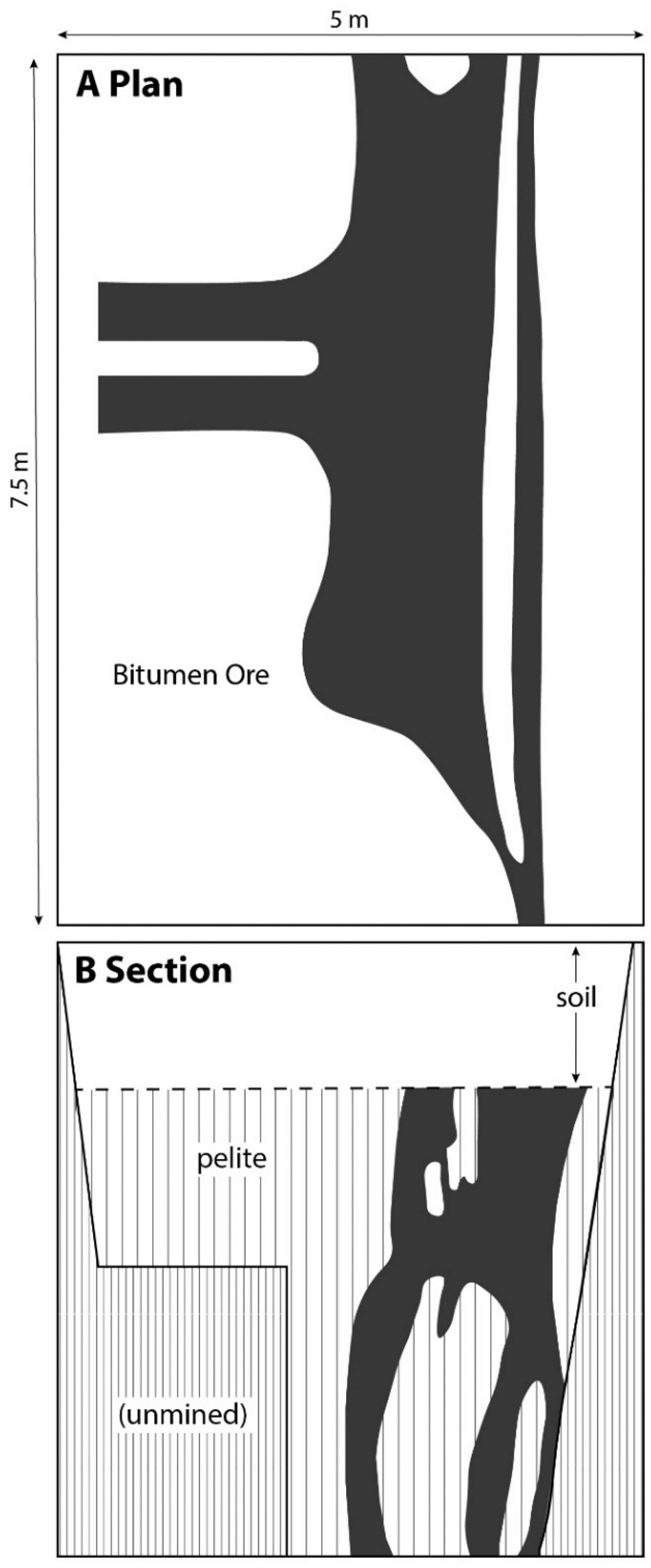
Cross-section and plan view of Kill Mine, Kilnaleck, shortly after discovery, showing distribution of bitumen (‘coal’) (after Whitty Reference Whitty1854). Later accounts indicate several shafts and excavation of galleries, to yield up to 1,000 tons of ‘coal’.
2.8. Irish independence
The fact of Irish independence, in the early part of the 20th Century, is not a distinct type of data, but rather a distinct circumstance that brought matters to the public record. Independence came when the origin of coal was well understood. However, the deposit at Kilnaleck was still considered a viable source of fuel, and it became a pawn in the politics of the time. Ireland was dependent upon British coal, which was potentially a problem, especially considering the added demands of the First World War and subsequent coal strikes in Britain leading to the general strike of 1926. These issues meant that Irish coal reserves were of great significance, and Kilnaleck became the object of close attention.
The United Irish League, which helped to form a platform for eventual independence, enthusiastically supported the mining of coal at Kilnaleck (Anglo-Celt 1901). The deposit was then dismissed by the Westminster parliament as untenable (Russell Reference Russell1912). However, Irish nationalist opinion was scathing of ‘the belief that there could not be coal at Kilnaleck! … Officials of the Department … have been hampered from the first by English trade jealousy…’ (Griffith Reference Griffith1917; note that Arthur Griffith, founder of Sinn Féin and soon to become the president of Dáil Éireann, was jailed three times for anti-British journalism). Local opinion held that ‘English influence was too strong to permit the opening of any Irish mine to thus compete against British coal … Indeed the local legend is that an English manager … had deliberately diverted a stream into the shaft and killed the industry’ (Anglo-Celt 1917). In April 1917, the Irish Independent (1917) lamented the refusal of the British Government Ministry of Munitions to permit import of essential pumping machinery for Kilnaleck and the resultant ‘choking off an Irish industry’. However, in June, Griffith (Reference Griffith1917) reported that pumping machinery had now been installed and was making good progress in dewatering the old pit. A visit from a (government) department expert saw the coal sampled, used, and given a good report (Freeman's Journal 1917). The Commission of Inquiry into the Resources and Industries of Ireland (1921) considered the coal could be of local value, possibly by being made into briquettes with clay. In these fledgling years of the Irish Republic, exploitation of Irish deposits was favoured, to minimise the dependence on British imported coal. Coal was in short supply anyway due to strikes in Britain, so Irish resources were prized. In 1925 the fuel shortage was exacerbated by failure of the peat supply and near-famine in the west of Ireland (Irish Central 2023). Free coal was distributed in rural areas including Co. Cavan, so there was frustration that Kill Mine was not functioning (Ballymena Weekly Telegraph 1925). The local T.D. (Irish Member of Parliament) persuaded President Cosgrove to honour a commitment by Griffith, now dead, to sink three coal shafts near Kilnaleck (Anglo-Celt 1925), but there is no evidence this was done. As the search for Irish supplies of coal took on a new urgency, there were also re-examinations of the Silurian deposits at Coalpits Townland, Slane, Co. Meath, and Lurgankeel, Co. Louth at about that time (Drogheda Independent 1917; Iron and Coal Trades Review 1918).
2.9. Mining companies
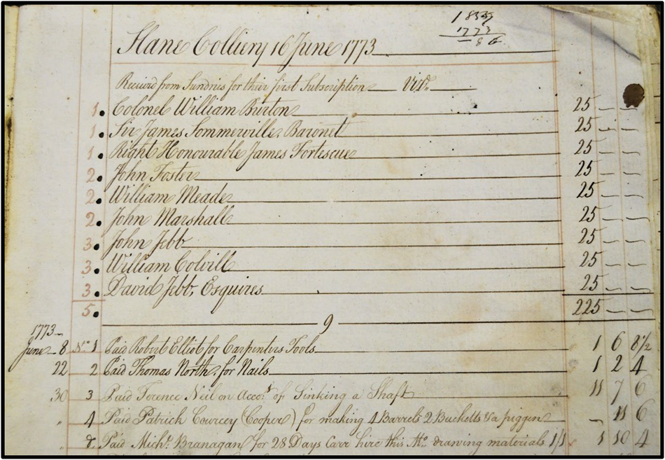
Mining operations rarely proceeded far enough, or formally enough, for written records by a legally constituted company to exist. A rare exception is the account book of the Slane Colliery (Fig. 13), held in the County Meath Library in Navan, but not transcribed (Slane Colliery 1773). It is mostly a record of the men and materials involved in construction of the mine shaft. The cost of workmanship is also recorded at Lindean, where an unpaid bill incurred in the search for coal was addressed by Sir Walter Scott in 1817, in his capacity as a judge (Chisholm Reference Chisholm1918).
Extract from account book, Slane Colliery 1773, showing list of subscribers and payments for carpenters' tools. Courtesy of Meath County Library.
There are, however, a few records of the subscription schemes arranged to finance pit construction, including at Lawrencetown, Co. Down, where the rate was five shillings (Belfast Telegraph 1872), and at Lindean (Craig-Brown Reference Craig-Brown1886). At Kilnaleck, there were several calls for subscription (Cavan Weekly News 1893; Dublin Daily Express 1913; General Advertiser for Dublin 1916), as each attempt to revitalise the pit over nearly 70 years needed money (Fig. 14). The non-payment of subscriptions (Anglo-Celt 1924, 1926; Belfast Telegraph 1926; Drogheda Independent 1926) heralded the end of the Kilnaleck venture. At Lurgankeel, Co. Louth, where boring into the Silurian was attempted through a thin veneer of ‘Old Red Sandstone’ (actually basal Carboniferous), £250 was raised from shares of £5, despite advice from Frederick Egan of the Geological Survey in Dublin (author of local geological sheet memoirs) that no coal would be found. In fact, the local view was that ‘not the slightest credence is attached to the opinion of that eminent geologist … his gratuitous interference is regarded with suspicion’ (Newry Telegraph 1872). So much for geologists. But 50 years later, samples from the ‘mine’ at Lurgankeel were being tested again (Iron and Coal Trades Review 1918), so there was at least some rock worth speculating about.
Newspaper advertisements for Kill Colliery, Kilnaleck. (Top) Sale of coal, 1856. (Middle) Raising subscriptions for re-opening, 1893. (Bottom) Payment of share instalments, 1918.
The scale and formality of mining at Kilnaleck is also indicated by several years of listing in the 1850s and 1860s in the UK Mineral Statistics under the ownership of Messrs. Moore & Co. (e.g., Hunt Reference Hunt1861).
2.10. The cultural record
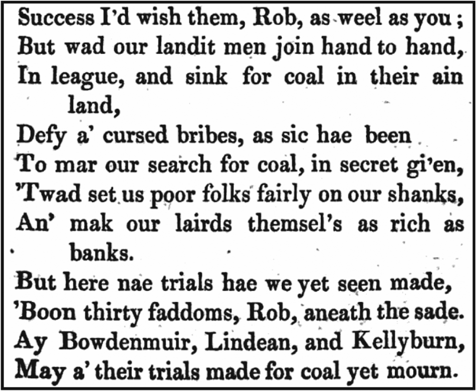
The idea of culture as a source of information about mining may be surprising to a geologist. However, pictorial records (sketches, paintings, photographs) are invaluable, and other data sources might include real locations in fictional writing and lists of people that include their employment. In the Southern Uplands, we benefit from the poetry of Andrew Scott, the Bowden Poet. Two of Scott's poems, ‘Panegyric upon Coal’ and ‘Rail-roads’ (Fig. 15) mention coal workings at Lindean, Bowdenmuir and Kellyburn, (Scott Reference Scott1821, Reference Scott1826), all in the vicinity of Melrose. Their incorporation into published poems suggests that these coal mining enterprises were well known. In ‘Rail-roads’, Scott alludes to the commonly held belief that deposits were not being worked because of ‘cursed bribes … to mar our search for coal’, as noted above in the Landowners section.
Extract from the poem ‘Rail-roads’ by Andrew Scott (Scott Reference Scott1826). The poem refers to coal trials in Silurian rocks at Bowdenmuir, Lindean and Kellyburn, and the belief that their development was prevented by bribery. Modern spellings are Bowden Moor and Kelly Burn.
The extensive archives relating to Sir Walter Scott, also resident in the vicinity of Melrose, have preserved several references to coal in the Silurian rocks. The lands of Scott's home at Abbotsford include an outcrop of carbonaceous Moffat Shale which was explored in several places (Fig. 16). The Bowdenmuir locality mentioned in the poems of Andrew Scott (no relation) is probably the site at Cauldshiels on the border of the Abbotsford Estate. The potential for coal would have been evident from the start of Sir Walter Scott's residence, as his purchase initially excluded land where the previous owner had been searching for it (Sir Walter Scott 1815–17): ‘My predecessor had an humour of digging for coal in it which prevented him including it in our first bargain’ (letter from Walter Scott to Daniel Terry, 25 December 1816).
Map of the Selkirk-Melrose region, showing trace of Moffat Shale bed along which several attempts were made to find coal. The extent of Sir Walter Scott's Abbotsford Estate in 1858 shows that the estate included coal prospects. The trace of the Moffat Shale was mapped by Lapworth (Reference Lapworth1870, Reference Lapworth1872).
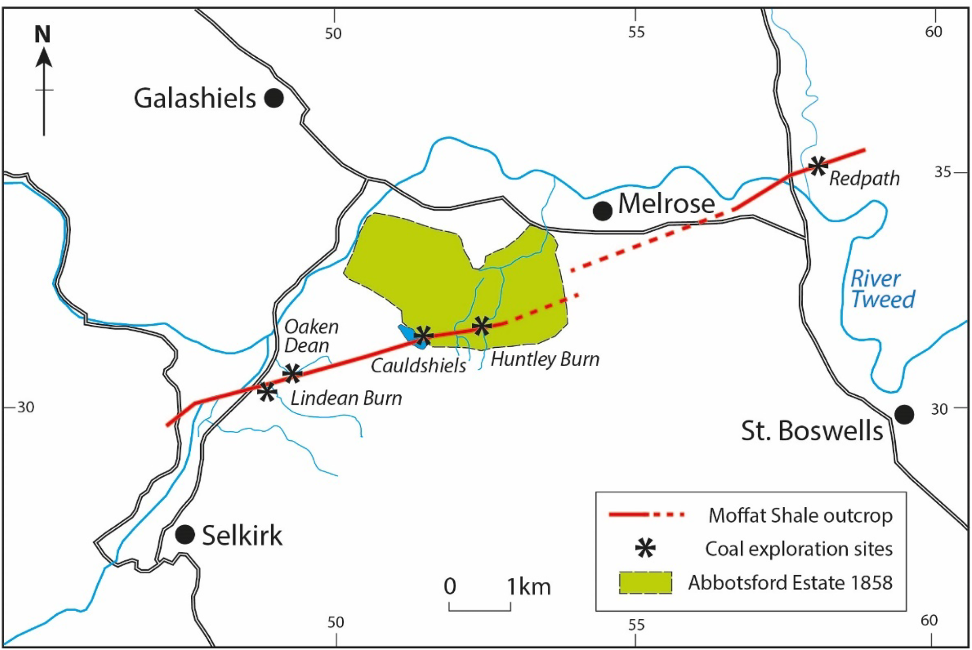
A subsequent letter to Charles Erskine (15 December 1817) records an exchange of land in Rhymers Glen (Huntley Burn) with Andrew-Seton Karr (‘Kerr’), in which Kerr retains mineral rights, specifically mentioning coal (Sir Walter Scott 1817–19). The precise location of the black shale bed crossing Rhymers Glen, which was confused with coal, was mapped by Forbes (Reference Forbes1853).
Scott also makes reference to the scarcity of coal in the region, and in a letter to the Duke of Buccleuch (24 April 1817) records the failure of his neighbours Nicol Milne and Scott of Harden to find it at Lindean and Maxton respectively (Sir Walter Scott 1815–17). Sir Walter Scott had copies of Andrew Scott's poems and, together with the interest in Lindean by his cousin (Buddle Reference Buddle1817a) and his judgement in the Selkirk Sheriff Court of a claim relating to exploration costs at Lindean in September 1817 (Chisholm Reference Chisholm1918), he must have been familiar with the interest in coal in the region.
Folk memory is an important aspect of the cultural record, but it is difficult to verify. Oral tradition can be very strong, but completely at odds with scientific evidence. For example, exploration for coal in the Silurian at Lurgankeel was in the context of family memories of mining coal 80 years previously (i.e., ~1790), a loss of life in a mining accident and the fear of haunting of the pit, and distraction from mining by the Irish Rebellion of 1798 (Dundalk Herald 1872; Newry Telegraph 1872). In 1872, this context was very real to the local population.
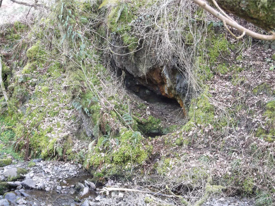
The cultural record extends to the present day, where the archaeological remains of coal exploration (Fig. 17) are documented by groups such as the Southern Uplands Mining Heritage Organisation (SUMHO). Numerous other local archives have preserved and catalogued documents which can be searched for information about coal exploration. Several of the sources cited in this review (Bell Reference Bell1733; Butler Reference Butler1744; Slane Colliery 1773; Taylor Reference Taylor1791; Buddle Reference Buddle1817a, Reference Buddleb, Hughes and Milne 1844) depend on these archives.
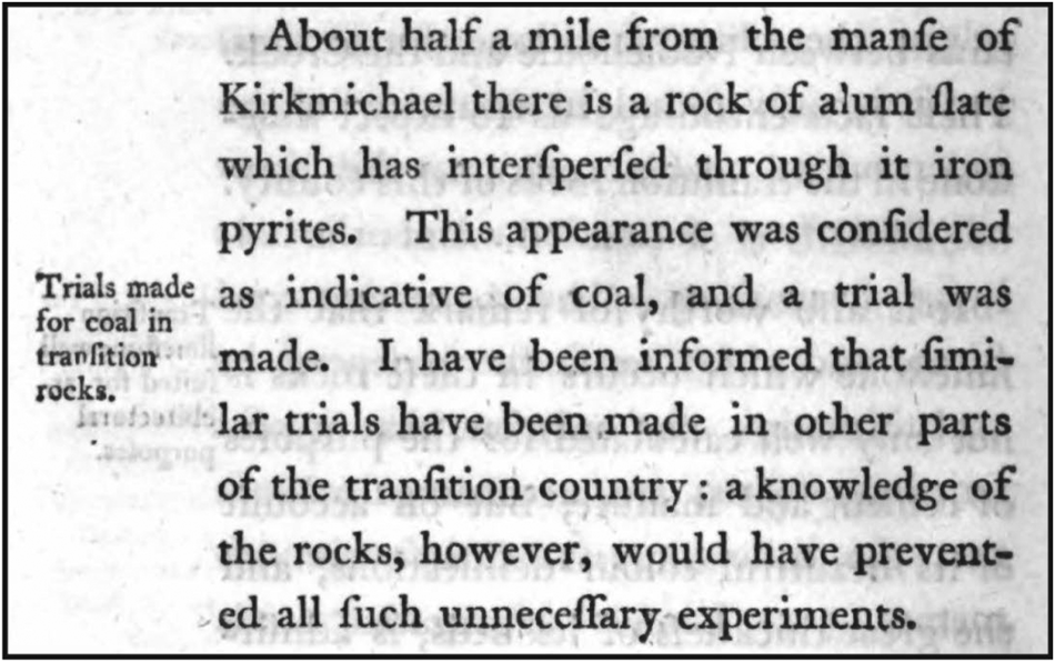
Shaft and working for coal exploration at Tuppark Linn, Kirkmichael (courtesy of SUMHO). The site is probably that of Jameson (Reference Jameson1805) who stated: ‘About half a mile from the manse of Kirkmichael there is a rock of alum slate … indicative of coal, and a trial was made’.
2.11. Scientific understanding
At the turn of the 19th Century, before many attempts to find coal had been made, geologists were already ruling out the ‘transition rocks’ as possible targets (Fig. 18), but documenting examples of misguided exploration in the process.
Extract from Jameson's ‘Mineralogical Description of the County of Dumfries’ (Jameson Reference Jameson1805) stating his view that the ‘transitional rocks’ (between crystalline basement and unmetamorphosed sediment, i.e., Silurian in this case) could not contain coal beds.
Jameson (Reference Jameson1805), in his Mineralogical Description of the County of Dumfries, described these trials as ‘unnecessary’, and more poetically, ‘If the gentlemen of Dumfries-shire are determined to sink or bore for coal in strata of (Old Red Sandstone), we strongly suspect … they may tickle the soles of the Antipodes before they find thick and very extensive beds of coal’. Fifty years later, Murchison (Reference Murchison1854) stated these searches were ‘absurd’. Lindsay (Reference Lindsay1863) scoffed at ‘Dumfriesshire lairds ruining themselves through expensive borings through these same Silurian slates’. A contemporary commentator summed up the issue: ‘It is as black as a coal, as hard as a coal, and as heavy as a coal; In short it is coal altogether, except that it will not burn’ (New Statistical Account of Scotland 1845b). Ironically, the discovery of ‘coal’ in the Silurian was so contrary to geological wisdom that it was reported widely. When a farmer digging a pit in the Silurian of Co. Cavan found the Kilnaleck deposit, the news was syndicated from the Cork Examiner (1852) to the John O'Groats Journal (1852). It is difficult to imagine such a spreading of the word by newspaper today. Most subsequent literature assumed that such mining attempts were mistaken, while overlooking the case of Kilnaleck. Nevertheless, when carbonaceous matter was encountered in excavations for waterworks in Silurian rocks at The Temple, Co. Down, in the early 20th Century, a correspondent (Robert Hanna) ‘brought large samples of these coals to Belfast’ and reported ‘better gas coal I never saw burnt’ (Northern Whig 1901).
Hydrocarbons generated from highly carbonaceous rocks did leave solid residues that were viable as a fuel. At Kilnaleck, where up to a thousand tons of fuel were extracted, it was sold in neighbouring towns. The fuel was favourably recommended by scientific heavyweights, including Sir Robert Kane (Irish chemist, the ‘boy professor’, who published the important Industrial Resources of Ireland (Kane Reference Kane1844)) and Sir Richard Griffith (Irish geologist, who published major reports on coal resources and the first complete geological map of Ireland) (Cavan Weekly News and General Advertiser 1872; Drogheda Argus and Leinster Journal 1880). Elsewhere, records of use by the local blacksmith or during hard winters in Co. Armagh (Egan Reference Egan1877) show that there were products which were highly calorific and abundant enough to fulfil a purpose. There may have been several instances where the enterprise was worthwhile at a local scale, but which will never be proven. The reasoning may have been ‘absurd’, as pronounced by Murchison (Reference Murchison1854), but the result was not always a waste of time.
3. Concluding remarks on the Moffat Shale
The written record preserves a story of exploration whose physical evidence is largely lost or hidden beneath the overprint of agriculture, forestry, housing and other development. Much of the exploration occurred at the end of the 18th and the early 19th Centuries. This coincided with the intense activity of the Industrial Revolution, when coal production in the UK was starting to escalate (Höök et al. Reference Höök, Zittel, Schindler and Aleklett2010; Ritchie Reference Ritchie2019) and there was a clear commercial drive to find new coal resources. Although the objective of exploration in Silurian rocks was misguided, the distribution of localities is a pointer to sites of geological deformation and fluid flow within the SUDLT. For example, around Melrose in the Scottish Borders, a series of mining endeavours can be mapped onto a highly deformed outcrop of carbonaceous Moffat Shale over a distance of 15 km (Fig. 16). Data from such sites, including the evidence of solid carbonaceous residues (the ‘coal’), contributes to an understanding of carbon migration in an accretionary prism (Parnell et al. Reference Parnell, Armstrong, Blamey, Boyce, Schito and Muirhead2023). Over the whole SUDLT outcrop, the horizons of carbonaceous shale played a fundamental role in building the prism geometry (McCurry & Anderson Reference McCurry and Anderson1989; Needham Reference Needham2004). The thrust-related slices in the prism are numbered as tracts 1 to 10 from north to south (Leggett et al. Reference Leggett, McKerrow and Eales1979; Leggett Reference Leggett1980; Morris et al. Reference Morris, Somerville and MacDermot2003). Mining attempts in the Silurian at Kilnaleck, Coalpit Bay and Lindean are in tracts 4, 6 and 8/9 respectively, showing that the whole prism outcrop was explored for coal. The shale horizons subsequently controlled the emplacement of igneous intrusions and mineralisation. The susceptibility to deformation of the soft shales helped to localise intrusions (Brown et al. Reference Brown, Ryan, Soper and Woodcock2008), while the reducing properties of the carbonaceous matter enhanced the deposition of metals including gold and antimony (Rice et al. Reference Rice, Cuthbert and Hursthouse2018; Parnell et al. Reference Parnell, Armstrong, Blamey, Boyce, Schito and Muirhead2023). In our environment, they play a role in hydrogeology because they act as low-permeability barriers to water flow (Macdonald et al. Reference Macdonald, ÓDochartaigh, Kinniburgh and Darling2007), and they allow subsurface mapping because of their distinctive conductivity (Beamish et al. Reference Beamish, Kimbell, Stone and Anderson2010; Beamish Reference Beamish2013). To this list we can add their stimulus for several centuries of exploration for coal.
4. Supplementary material
Supplementary material is available online at https://doi.org/10.1017/S1755691024000069.
5. Acknowledgements
Numerous people helped us to access documents, including Jennifer Hillyard, The Common Room of the Great North; Nick Parkes and Pete Bradshaw, Durham County Record Office; Geraldine Fanning and Tom French, Meath County Library; Lorraine Grattan, Armagh Robinson Library; and Paul Brough, Live Borders. We also thank the Ordnance Survey of Northern Ireland and the National Library of Scotland for permission to reproduce maps, Jamie Bowie for skilled cartographic work, Walter Elliot and Alison Lumsden for advice, and the landowner at Townhead Farm, Parkgate, Dumfries. The British Newspaper Archive and Irish Newspaper Archives were invaluable resources. Patrick Roycroft, National Museum of Ireland – Natural History, kindly provided images of bitumen from Ireland. We are grateful to two anonymous reviewers and the editor, whose expert advice improved the paper.
6. Financial support
J.G.T.A. was partly supported by NERC grant NE/T003677/1.
7. Conflict of interest
None.


 Open access