


Introduction
The Achaemenid Royal Road has long been recognised as a hallmark of the Achaemenid Empire (550–330 BC), regularly referenced for its scale and organisation (e.g. Colburn Reference Colburn2013). Yet despite its prominence, the structural criteria that defined a road as ‘royal’ have rarely been examined. Previous reconstructions—often based on classical sources or modern infrastructure alignments—have paid limited attention to the logistical systems required to support large-scale royal movement.
Rather than treating the Royal Road as a generic communication route, this article advances a more functional definition of it as an engineered corridor designed to meet the operational demands of the Achaemenid court in motion. Classical authors describe a peripatetic convoy numbering in the thousands, accompanied by wagons (harmamaxai) and pack animals (e.g. Curtius Rufus, History of Alexander, 3.3.8–25; Rolfe Reference Rolfe1946). Supporting such movement required more than narrow courier paths. It would have demanded a certain set of stable logistical conditions, including a gentle slope for wheeled vehicles, reliable access to water, regular halting points and intervals of level terrain for large encampments. This approach does not seek to retrace historically attested itineraries, but to define the spatial and logistical criteria that enabled a route to function as ‘royal’ in operational terms.
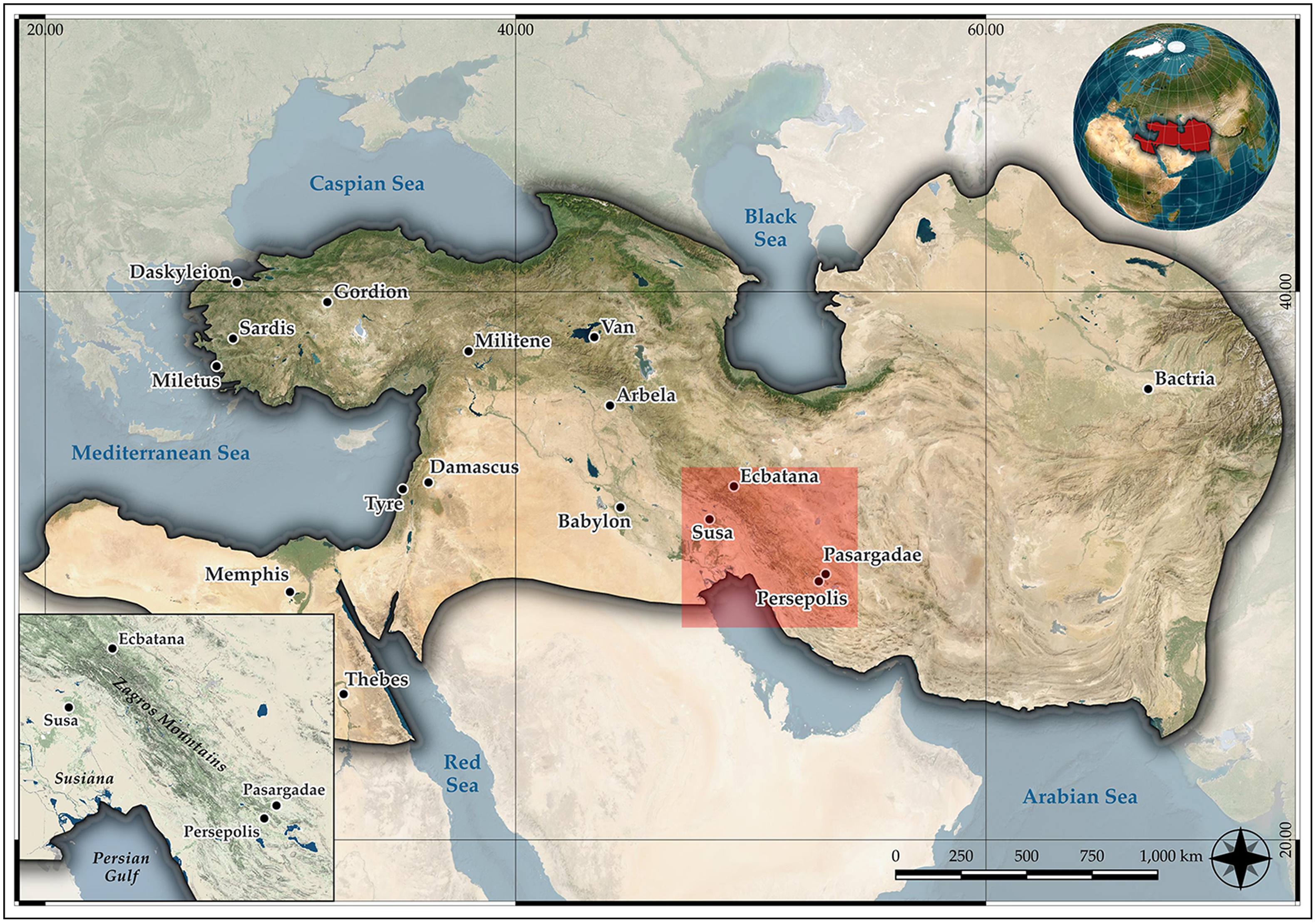
Focusing on the road between Susa and Persepolis (Figure 1), in modern-day Iran, the Marie Skłodowska-Curie Actions-funded PersianTRAIL project applies spatial predictive analysis to identify suitable travel corridors. Its aim is to evaluate topographic conditions for royal-scale movements and clarify the infrastructural characteristics that shaped their design.
Extent of the Achaemenid Empire; inset, the Susa-Persepolis area (figure by author).

Method
Unlike least-cost path (LCP) models, which define a single optimal line, this study applies least-cost corridor (LCC) modelling to identify broader areas that better reflect the variability of ancient travel. Corridors are derived by combining cumulative cost surfaces from both endpoints into a Conditional Minimum Travel Cost (CMTC) grid:
 $${CMTC ={\it\hbox(} {cost{{\; }}from{\rm{ \;}}A + cost{\rm{\; }}from{\rm{\; }}B} {\it\hbox)}/2}$$
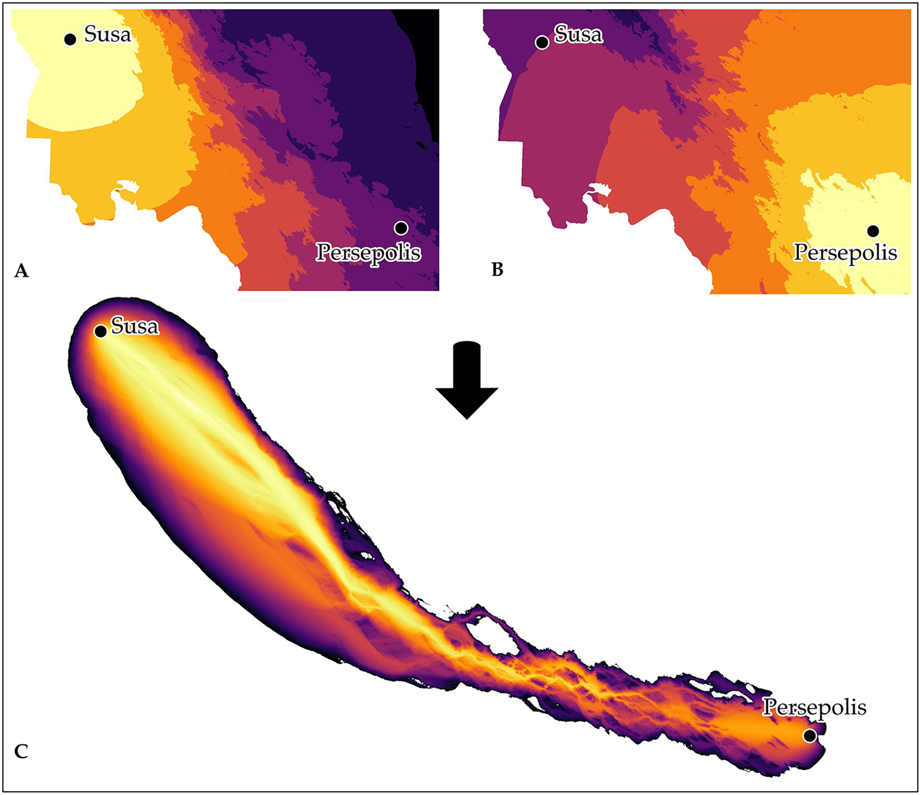
To isolate the most viable zones, the model extracts the lowest decile of CMTC values (i.e. the 10% least-resistant cells; Figure 2). While arbitrary, this threshold follows established practice and narrows the analysis to the most plausible movement zones (Pinto & Keitt Reference Pinto and Keitt2009).
Procedure for generating a CMTC grid for the Susa-Persepolis Corridor: A) cumulative cost surface from Point A (Susa) to Point B (Persepolis); B) cumulative cost surface from Point B (Persepolis) to Point A (Susa); C) corridor created by adding the two grids A and B. The lighter shades indicate the easiest corridor to traverse (figure by author).

The 30m Shuttle Radar Topography Mission (SRTM) digital elevation model (DEM) was selected for its full coverage of the study area. Although higher-resolution datasets exist (e.g. ALOS PALSAR, TanDEM-X, 12.5m), access limitations reduce their utility. SRTM-30m offered adequate resolution for macro-scale modelling and topographic analysis.
A critical slope of eight per cent was set, reflecting the maximum gradient manageable for animal-drawn wheeled transport, based on comparative data from Roman roads analysis and ancient transport studies (Herzog Reference Herzog, Contreras, Farjas and Melero2013 and references therein). Slopes exceeding this threshold were penalised using a quadratic cost function:
 $${Cost (s) = {\it 1} + ( s/\unicode{x02C7}\!\!\!{s})^{\it 2}}$$
(s = slope; š = critical slope)
This discourages steep terrain without making it impassable, mirroring the pragmatic flexibility of ancient travel logistics. Areas altered by modern infrastructure (e.g. reservoirs) and floodplains were manually excluded to better approximate ancient conditions.
To validate results, predicted routes were compared with known Achaemenid sites interpreted as potential waystations (e.g. Potts Reference Potts, Briant and Henkelman2008). This integration of environmental data with archaeological evidence generates testable hypotheses on the infrastructure needed for royal-scale movement.
‘Royal’ road, ‘royal’ needs
In the Achaemenid context, the PersianTRAIL project argues that a road was considered ‘royal’ (hodos basilike) by its capacity to sustain large-scale logistical operations involving the royal convoy, army, and associated elements. Relocation of the imperial court was a structured mechanism of governance central to the Great Kings. By moving seasonally between major centres across the empire—such as Susa and Persepolis—Achaemenid rulers projected tangible imperial presence and engaged directly with local elites and diplomatic delegations by hosting formal receptions along the royal routes (cf. Briant Reference Briant2002; Henkelman Reference Henkelman, Jacobs and Rollinger2010). This practice imposed clear topographic and spatial constraints that shaped the design and layout of the road infrastructure.
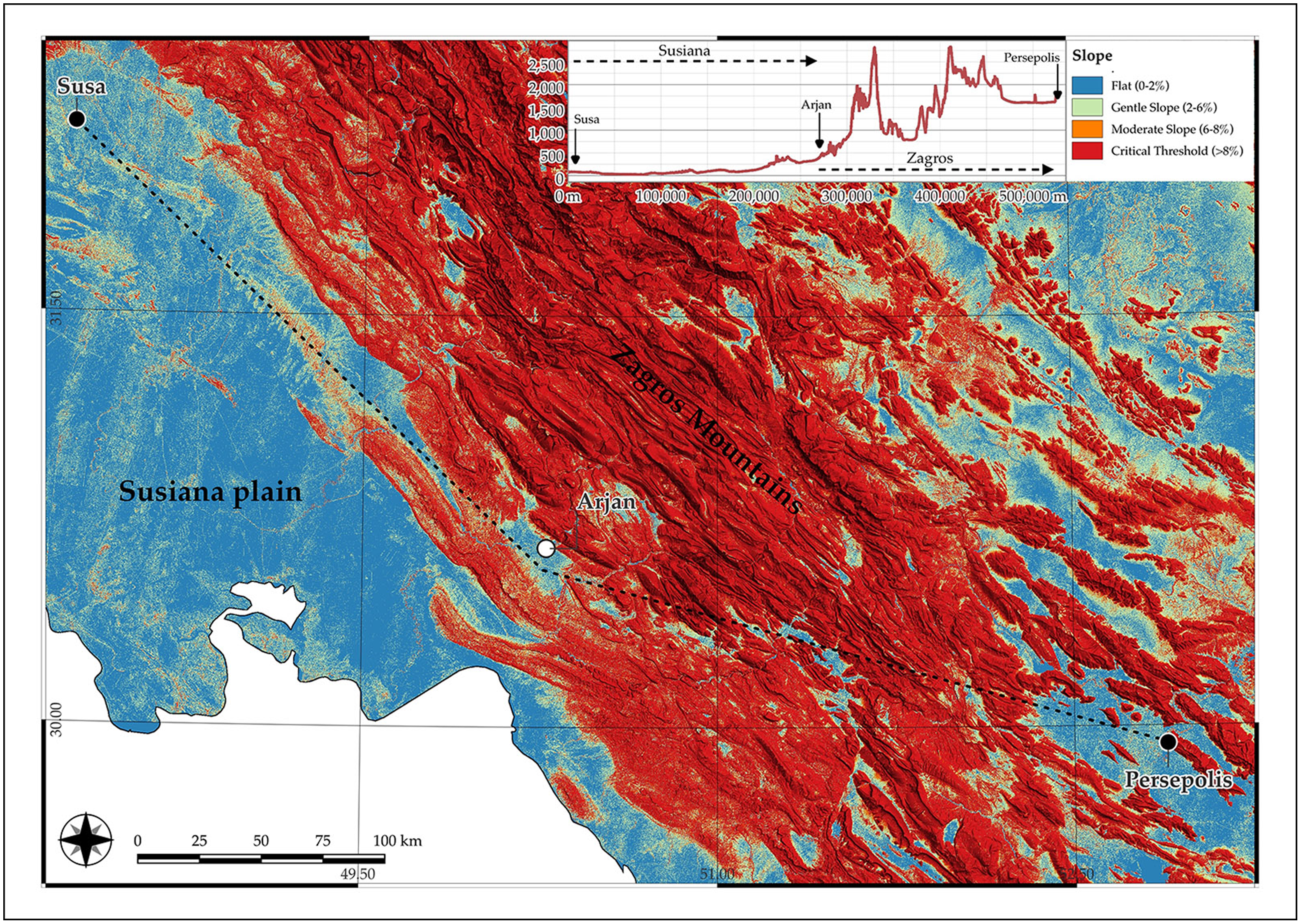
The slope was likely a primary factor, given the involvement of wheeled vehicles. Roads required gentle gradients to ensure steady movement of the court, as steeper inclines would have introduced mechanical strain that harmamaxai could rarely manage (Figure 3).
Slope threshold and topographic profile between Susa and Persepolis (figure by author).

Width was equally important. Narrow tracks could force the royal convoy into a single column, creating long, slow-moving processions with limited manoeuvrability. A train of 20 000 individuals (cf. Athenaeus, Deipnosophists, 4.146.d; Gulick Reference Gulick1928) moving in single file could stretch 10–15km (Lee Reference Lee2007), extending beyond 40km when including pack animals and wagons (Bachrach Reference Bachrach and Pryor2006). With waystations typically spaced 15–20km apart, as archaeological evidence suggests (Potts Reference Potts, Briant and Henkelman2008), such conditions would have severely compromised logistical coordination. Royal roads likely measured 5–7m in width—comparable to Roman standards in West Asia (Hagen Reference Hagen1967)—to permit multiple columns of movement. Potential traces of such roads have been reported in Iran (Sumner Reference Sumner1986).
Halting points functioned as key logistical nodes. Classical sources distinguish modest courier stations (hipponeis) from royal stations (stathmoi basilikoi). During court relocations, the latter operated as temporary imperial capitals, equipped with pavilions, storage buildings and direct access to food and water sources (Briant Reference Briant2002). Their placement—in spacious, flat, well-watered terrain—would need to have been strategic, enabling the royal encampment and sustaining the ‘King’s Table’. The Persepolis Fortification Archive (PFA) supports this model, linking such stations with royal estates (ulhi) and paradises (partetaš), and documenting supplies systematically delivered ‘before the King’ to these elite locations (Henkelman Reference Henkelman, Jacobs and Rollinger2010).
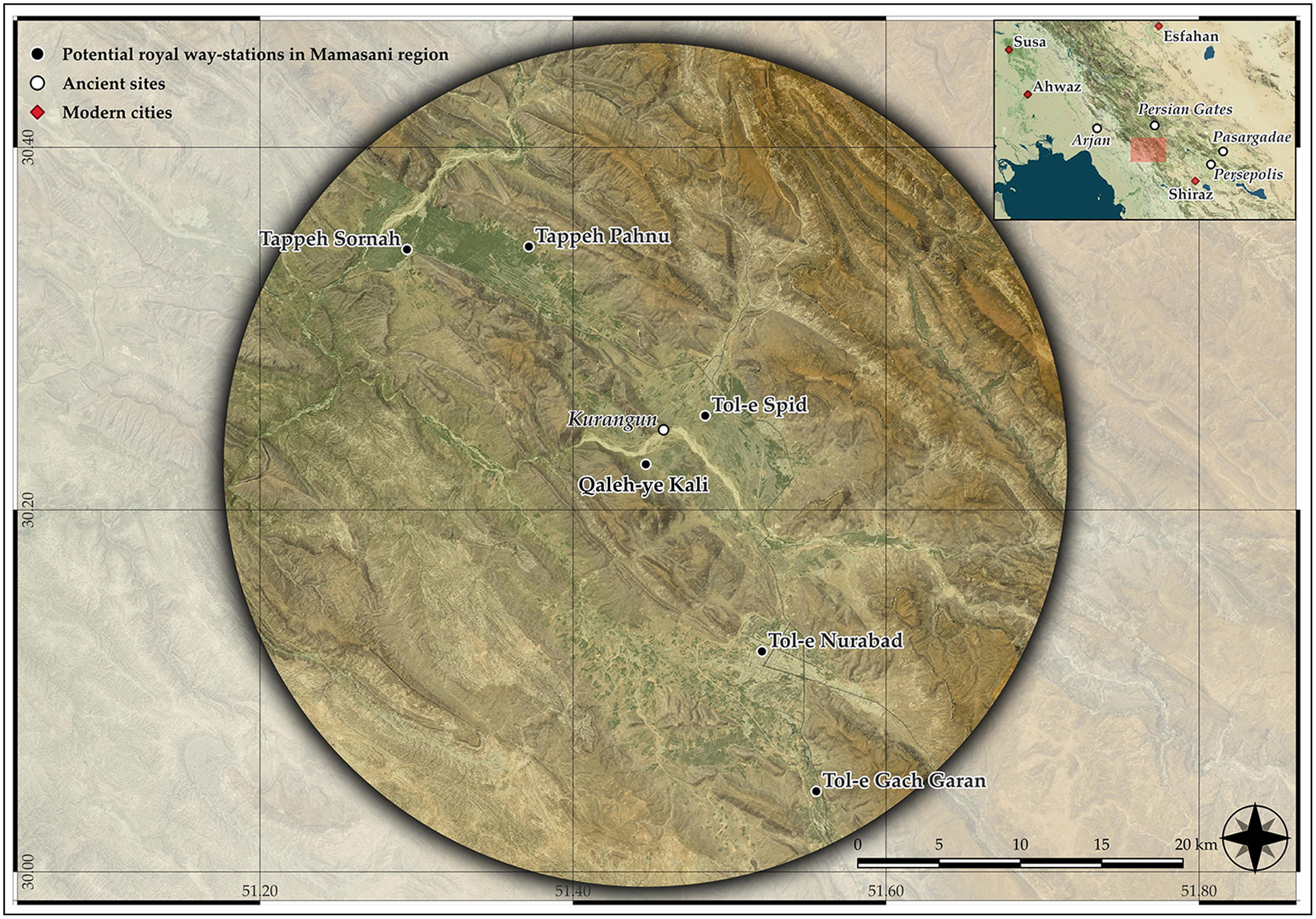
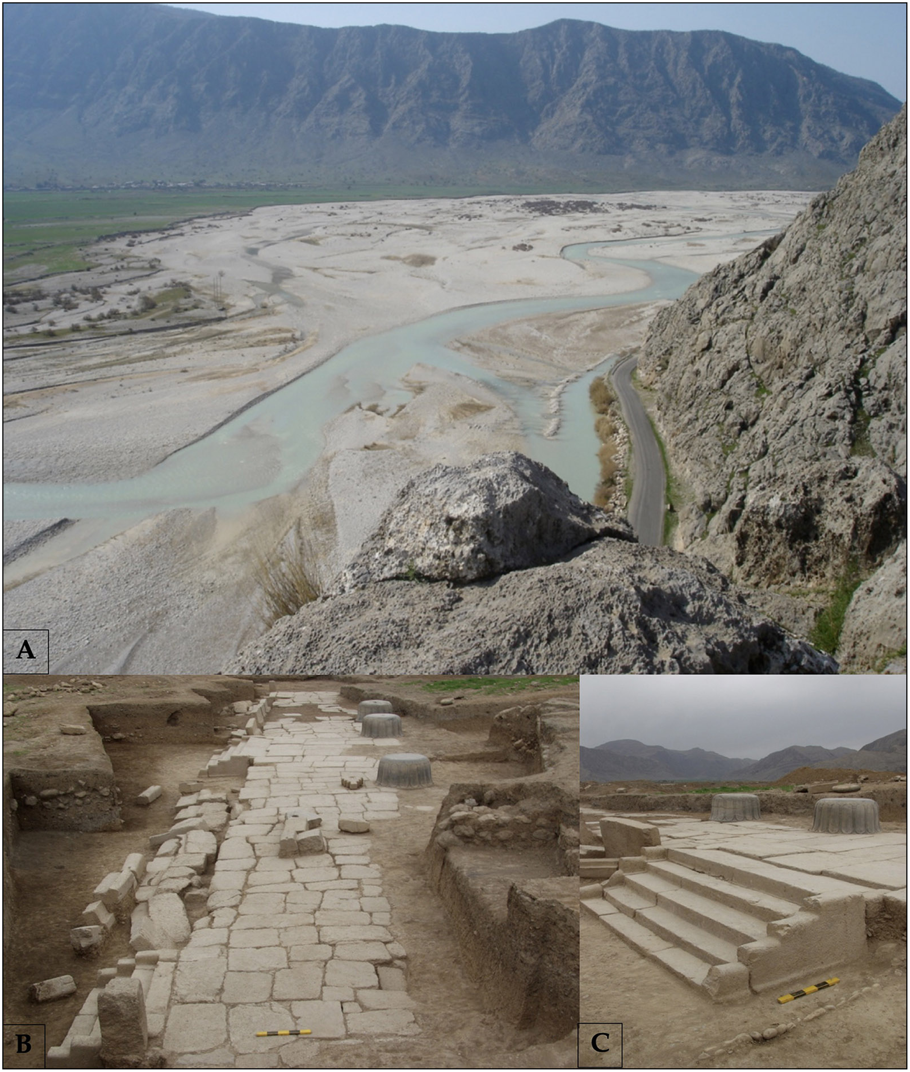
Archaeological evidence reinforces this system. Qaleh-ye Kali in the Mamasani area (Figure 4) offers a compelling case. Architectural features, elite artefacts and storage facilities point to a logistical function consistent with royal use (Dusting Reference Dusting2014), while its location within the modelled corridor—in an open, fertile plain shaped by the Fahliyan River—highlights its strategic integration into the Royal Road network (Figure 5).
The Mamasani region (figure by author).

A) The view south-west over the Fahliyan River toward Qaleh-ye Kali, seen from Kurangun relief; B & C) Qaleh-ye Kali portico (images from Dusting Reference Dusting2014: figs. 4.3, 5.4, 5.5, respectively).

Conclusion and future work
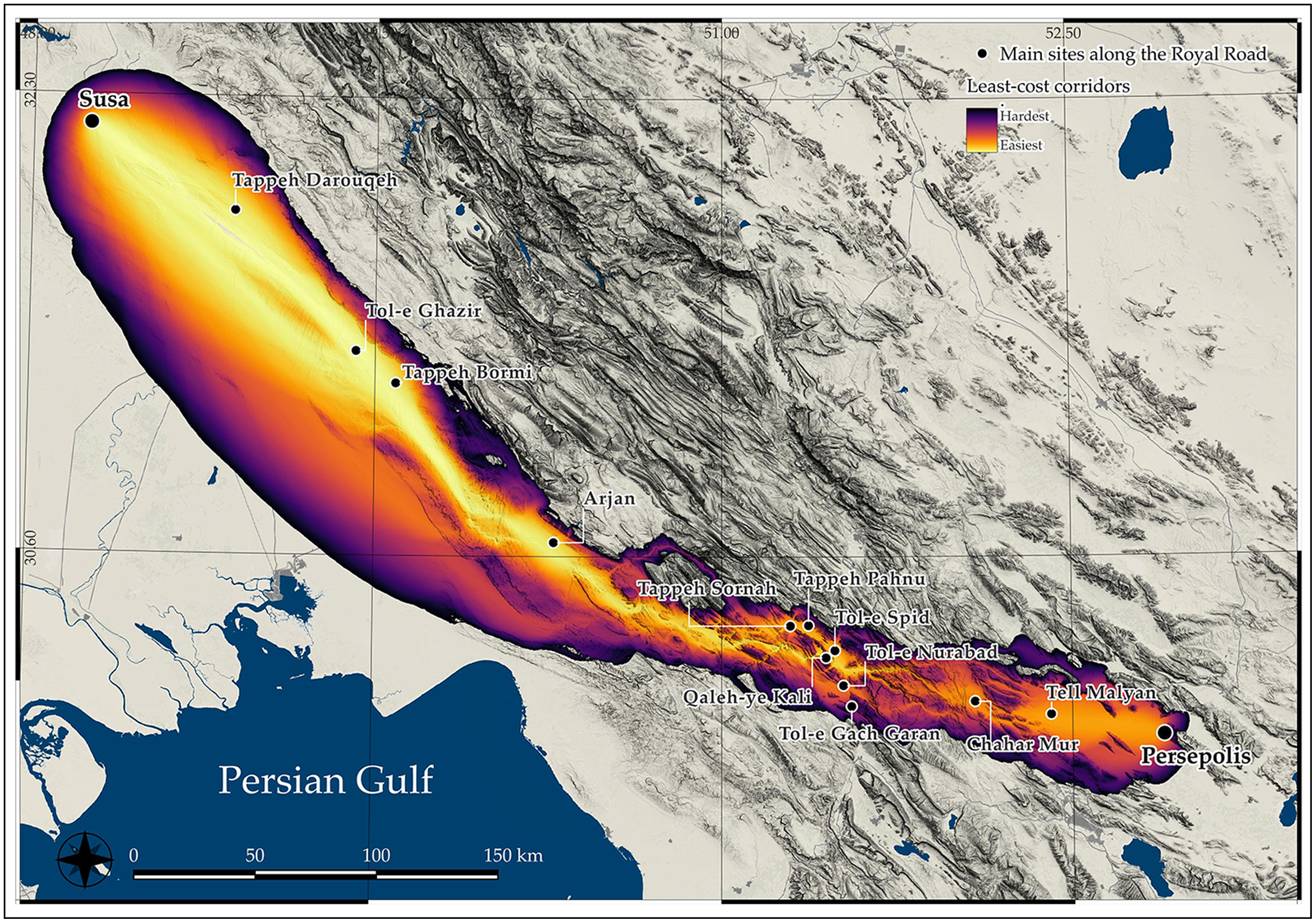
This research introduces a new operational definition of the Achaemenid Royal Road, grounded in the spatial and logistical requirements of imperial mobility. Using GIS predictive modelling, integrated with archaeological data, it identifies high-probability corridors between Susa and Persepolis that reflect these conditions (Figure 6).
Least-cost corridors between Susa and Persepolis (figure by author).

Preliminary modelling suggests that route planning responded to specific practical factors—such as slope tolerances for wheeled transport, the need for a minimum road width and access to regular infrastructure—distinguishing Royal Roads from ordinary routes. These criteria establish a testable framework for spatial hypotheses, refinable through archaeological validation and applicable across other segments of the imperial network.
Future phases of the PersianTRAIL project will extend the model westward toward Sardis, incorporating additional data from the PFA records, alongside settlement patterns, land use, vegetation and seasonal climate. Sociopolitical factors—including regional instability or local autonomy—will also be integrated to refine route modelling. Archaeological verification of predicted halting points will be essential to further calibrate the model’s accuracy and broader applicability. Finally, while necessarily selective, the present analysis provides an interpretative model that will be deepened through future integration of historical route narratives.
By anchoring ancient mobility in measurable conditions, this geospatial approach serves as a durable and transferable tool for analysing large-scale movement and its supporting logistics in imperial contexts, while offering a replicable method for determining the spatial and infrastructural criteria by which a road functioned as ‘royal’.
Funding statement
The PersianTRAIL project has received funding from the European Union’s Horizon programme (MSCA-2023-PF, Project: 101149736), administered by UK Research and Innovation under the Horizon Europe guarantee. It is hosted at the McDonald Institute for Archaeological Research, University of Cambridge, with Professor Cameron Petrie as academic mentor.

 Open access