




Introduction
By the summer of 1945, an overwhelming number of cities throughout Poland, Germany and Britain – to name just three heavily affected countries in Europe – existed in different states of decay and decomposition. While authors of post-war European urban histories often begin their stories by invoking the total and uniform nature of World War II destruction,Footnote 1 war damage maps tell a different tale. Their complicated hatches, outlines, tints, tones and shades take readers on a journey through the material, social and political realities of urban catastrophe, impossible to explain through statistical summaries alone. As key documents that coterminously recorded and orchestrated the transition from ruins to new modernist (often socialist) urban ideological and spatial orders, they help scholars imagine how professionals across eastern and western Europe participated in an ambivalent search for the ideal post-war city.
Our purpose in this article is to introduce cartographic damage records as viable scholarly sources for urban historians working on qualitative analyses of reconstruction, and to position damage cartography as a new subfield in comparative urban history. Read in tandem with development plans, war damage maps found in archives and private collections around the globe help articulate the subjective processes by which engineers, architects and planners extracted economic, aesthetic and historic value from ruins and rubble. Iterative in nature, damage maps can be used to track the incremental material and social reorganization of the urban organism, including the significant morphological alteration of historic town centres so often passed off as faithful reconstructions. At the same time, it is crucial to acknowledge that war damage maps are limited in their capacity to generate empathetic discourses, especially those surrounding the reality of mass human death and burial, conspicuously missing from their legend categories.Footnote 2
For decades, scholars of post-war reconstruction have used damage records primarily to calculate material and monetary losses, utilizing damage maps as passive illustrations of those losses. Damage cartography, as a source of subjective information about the social and political tensions that characterized the reconstruction process, remained untapped until the early 1990s. In 1991, geographer Uta Hohn first began to question the statistical reliability and consistency of maps, but remained focused on quantitative analyses.Footnote 3 Based on subsequent studies of the wartime operation of the London County Council (LCC), as well as the German Task Force for Reconstruction Planning of Destroyed Cities (Arbeitsstab Wiederaufbauplanung zerstörter Städte), in the early 2000s, Robin Woolven and Niels Gutschow published on the broader qualitative dimension of war damage maps. Building on connections that Woolven and Gutschow establish between damage mapping and urban ‘improvement’ projects in Britain and Germany, our work situates individually pursued studies of the early post-war reassemblage of Warsaw and Munich within European architectural, town planning and heritage conservation discourses.Footnote 4
Specifically rooted in analyses of damage mapping practices documented in both cities, we propose a three-part argument: we suggest that the continuous presence of damage maps in European urban history is inconsistent with the dearth of scholarly literature on the subject; that the praxis of damage cartography in Europe has its roots in late nineteenth-century thematic mapping and urban archaeology; and that damage mapping was crucial to the conceptualization of heritage zones as integral elements of modernist urbanism. Embedded from the start in planning processes, damage maps both recorded and acted on existing conditions. In other words, it is tempting to see damage maps as objective evidence of the state of wartime destruction, but taken together, these maps often document a lengthy and recursive post-war process of evaluation and selection of structures to be maintained and those to be removed. As our comparison of Munich and Warsaw suggests, analytical and archaeological damage mapping guided political decisions about the preservation of entire heritage districts. As a form of urban planning, damage assessment and mapping contributed significantly to what we are calling a heritage-making momentFootnote 5 – a remarkably short period of time during which the newly conceptualized historic town centres of dozens of European cities were moulded to represent both the achievements of post-war reconstruction and the paradoxically celebrated immutability of an imagined pre-war heritage.Footnote 6
War damage maps in public circulation
While there is a vast literature on the material and social effects of urban disaster throughout human history, and equally extensive research surrounding World War II aerial bombing and subsequent reconstruction practices,Footnote 7 scholars have rarely used war damage maps as sources for the study of change in urban environments. The rich collections of damage maps found in European archives stand in stark contrast to the relative poverty of geographic and historical work on the subject, including methodological analyses. Due to the dispersal of damage maps in local archives, their temporary nature as working documents, and their classification as ‘secret’ throughout the 1940s, comparatively little has been written on the influence of damage assessment and mapping on town planning practices.Footnote 8
Damage maps were made during and after World War II by Allied and Axis countries throughout Europe. In Germany and Britain, the municipal archives of almost every affected city contain some form of damage cartography: London, Coventry, Hull, Manchester, Berlin, Frankfurt, Hamburg, Nuremberg, Munich and Augsburg – to list only the archives that we have visited or digitally consulted – all collect World War II damage maps.Footnote 9 The State Archive in Warsaw (Archiwum Państwowe w Warszawie, APW) and the London Metropolitan Archives (LMA) hold the most complete damage assessment records: from survey sheets and sketches prepared in situ, to meticulously crafted war damage maps covering the large metropolitan areas of both cities.Footnote 10 As such, the collections have been listed in the UNESCO Memory of the World register, and have received funding for conservation and extensive digitization.Footnote 11
As classified documents, damage maps surfaced slowly in post-war publications, usually in simplified form. In the late 1940s and early 1950s, German and Polish architectural and engineering periodicals rarely published actual war damage maps, instead focusing on new urban design projects, as well as materials research, especially as it related to the recycling of rubble.Footnote 12 Starting in the 1960s, and then intensifying in the 1980s following the German Historikerstreit and the gradual loosening of censorship in eastern and central Europe, German historians such as Edgar Wedepohl, Hartwig Beseler and Niels Gutschow assembled, edited and published damage maps.Footnote 13 Beseler and Gutschow's seminal multivolume work, Kriegsschicksale deutscher Architektur, was the first series to illustrate urban conservation practices using damage maps. Most of the maps printed in these volumes were redrawn and standardized for publication, often omitting three-dimensional data communicated by overlaid hues and hatches.
As mentioned above, in the 1990s, Hohn challenged the reliability of damage statistics and maps as objective historical sources. Based on exhaustive archival work, she showed that the heterogeneous legal bases for damage mapping rendered equally heterogeneous results later prone to uneven readings.Footnote 14 Ann Saunders and Robin Woolven published the first complete collection of the LCC bomb damage maps 14 years later, sparking wider interest in the relationships between war damage mapping, urban planning and heritage conservation. Building on Kriegsschicksale, Niels Gutschow and Jörn Düwel subsequently edited a volume that uses large-format colour reproductions of war damage maps of German cities from Gutschow's personal collection to investigate wartime urbanism throughout Europe.Footnote 15 Between 2012 and 2016, Jerzy Elżanowski and Carmen M. Enss separately published detailed analyses of war and bomb damage maps prepared in Munich and Warsaw during and after the war.Footnote 16 Concurrently, David Fedman and Cary Karacas analysed both US military and Japanese civilian target and bomb damage maps of several cities, including Tokyo, Osaka, Hiroshima and Nagasaki.Footnote 17 Taken together, this recent work asks urban historians to rethink the value of damage maps as sources of summative statistical data about destruction in favour of qualitative interpretations. Its aim is to use cartography as a way to narrate the administrative, design and ideological transformations that led from damage assessment to wartime and early post-war urban planning, including early forms of European heritage planning.Footnote 18
The practice of damage cartography
Mapping existing conditions and planning for change have always been deeply entwined processes. As such, the history of urban mapping shows a recursive progression of visualization strategies that have both responded to and enabled urban growth.Footnote 19 As Ola Söderström argues, urban maps and plans have never been ‘the passive repository of an exterior planning process, but one of the key sites of urbanism in the making’.Footnote 20 The idea that maps as particular ‘modalities of visualization’ have a certain agency is now widely accepted,Footnote 21 but to date, scholars have treated damage maps as chronicles of a largely passive process. By contrast, we argue that damage maps have long been used to legitimize dramatic urban clearance projects, imagined and yearned for even before the catastrophes that made them possible. The emergence of heritage mapping and planning, which we attribute to the years 1880–1950, follows from over two centuries of continuous historical evidence of damage cartography deployed for planning purposes.
Since the second half of the seventeenth century, damage mapping has been explicitly linked to city planning and discourses surrounding urban sanitization. Following London's Great Fire of 1666, King Charles II commissioned a group of surveyors, scientists and engravers – Christopher Wren among them – to produce damage surveys and subsequent plans for the rebuilding of London.Footnote 22 From the outset, the king's goal was to improve London's ‘salubrity’,Footnote 23 and, as an eighteenth-century copy of Wren's plan for London claims, to bring ‘light, air, [and] cleanliness’ to the devastated city.Footnote 24 Damage mapping as a tool for visualizing the spatial effects of disaster continued through to the nineteenth century, when maps recorded losses resulting from catastrophic fires in cities such as Moscow (1812), Hamburg (1843) and Chicago (1871).Footnote 25 Extensive fire damage and excessive industrialization, paired with the need to house rapidly growing populations, fuelled late nineteenth-century discussions about the nature of the modern city, including appropriate ‘sanitary’ planning and zoning methods. Work in zoning and social mapping done in the 1880s by the German engineer Reinhard Baumeister and British social activist Charles Booth, in combination with an increasing interest in historic architecture, contributed to a robust culture of thematic cartography, later deployed in the twentieth century to model, implement and track urban development plans.Footnote 26
Cumulatively, the urban destruction caused by two world wars made the wholescale reorganization of the industrial metropolis tragically imaginable and physically possible. Early Zeppelin and later aeroplane bombing campaigns of World War I forced municipal authorities in cities such as London, Paris and Venice to compile damage statistics and make bomb incident maps.Footnote 27 Smaller cities, like Kalisz in Poland, required detailed damage mapping early in the war, and subsequent long-term reconstruction planning.Footnote 28 Following the war, fire prevention specialists in 1920s London brought together cartography and engineering, publishing highly detailed structural damage analyses of bombed buildings.Footnote 29 Two decades later, these indirectly manifested as national guidelines for urban reconstruction prepared in Nazi Germany by the aforementioned Task Force for Reconstruction Planning of Destroyed Cities.Footnote 30
In combination with experiences gained in thematic mapping, ever more closely entangled damage assessment and crisis management gave rise to the sophisticated damage cartography observed throughout Europe during and after World War II. Along with target charts, aerial photographs and damage assessment reports, World War II damage maps constituted what Fedman and Karacas call a ‘geographical psychology of war’. People ‘turn[ed] their gaze to maps’ that ‘became integral to the myriad exigencies of the war itself’.Footnote 31 Especially in the early 1940s, architects, technicians and civilians compiled damage reports and made maps in numerous German, British and even occupied Polish cities. Rooted in security and fire prevention measures, these wartime maps often managed the mechanics of compensation and individual reconstruction permits.Footnote 32 As carpet bombing and resultant fires began to destroy entire city districts, the focus of damage surveying and mapping shifted in a scalar way towards questions of comprehensive urban, regional and even national reconstruction planning.
Continuously applied throughout World War II, the military cartographic gaze extended beyond the spring and summer of 1945, as civilian architects and planners celebrated the unprecedented opportunities for urban renewal that large-scale destruction had afforded them. Using Coventry City Architect and Planning Officer Donald Gibson's aphorism – ‘the raid on the city had been “a blessing in disguise”’Footnote 33 – Düwel, Gutschow and Woolven all draw similar conclusions about the intellectual climate among architects working to recover from war: wartime destruction was naturally lamented across Europe, but it was also, almost uniformly, seen as an opportunity for a radical rearticulation of the urban organism following modernist planning principles. As we will show, though focused on urban expansion, modernist planning in cities such as Warsaw and Munich nonetheless foregrounded the reconstitution of distinct heritage zones.
Archaeological mapping and heritage zones
While we agree that architects saw damage sustained during World War II as an opportunity to solve the pressing problems of the overcrowded industrial city, we also suggest that historic town centres have their own, unique histories, and require a separate analysis. Beyond the fulfilment of lingering pre-war commitments to urban hygiene, rebuilding historic town centres after 1945 involved a negotiation of changing legal and cultural obligations to preserve the remains of a pre-war historical fabric, and the development of renewed mandates to produce and promote distinct national heritage. Damage mapping, as a form of mourning the loss of key sites of cultural heritage, came with the possibility for liberation from dense nineteenth-century fabric, from real estate speculation and from private land ownership. Mapping served as an evidentiary basis for the construction of hybrid ‘old towns’ (Altstädte) with lowered density and modern architectural programmes, already imagined and desired in the late nineteenth century.
Methods for tracking and relationally representing factors such as social class, population density and land value in urban aglomerations, separately developed by Baumeister, Booth and others, contributed to strategies ostensibly aimed at solving the real and perceived problems of overpopulation, low housing quality and crime, especially in older city districts. By maintaining socially, functionally and economically specialized zones, argued Baumeister, the urban organism could be administered effectively and predictably.Footnote 34 Amidst growing anxieties surrounding the intensive industrialization of cities, and the progressive neglect of historic buildings, architects and conservationists began to assert the presence of historic architecture in surveys, maps and plans. Late nineteenth-century urban archaeology, as Guido Zucconi suggests, developed ‘a new kind of knowledge’, deployed to ‘unearth the information required to reconstruct, both in form and character, all or part of a city that ha[d] disappeared or [was] doomed to disappear in the process of modernization’.Footnote 35 Zoning thus became a strategy for the selective conservation of historic districts.
Miles Glendinning, like Zucconi, recognizes that a complex constellation of influences and debates shaped inter-war European conservation practice in relation to planning discourses. According to Glendinning, despite the fact that ‘there was a wide consensus on the need for planned urban decentralization and land-use zoning…conservation-oriented planners favoured a different policy, of elaborated conservative surgery, including functional modernization’.Footnote 36 The term ‘surgery’, first formulated in the context of heritage conservation by Gustavo Giovannoni in 1913 as diradamento (pruning or thinning), has its history in the urban archaeology movement of late nineteenth-century Italy.
In the 1890s, northern Italian cities, particularly Florence, began to create extremely detailed maps of their historic city centres in reaction to radical plans for the demolition of entire districts on the grounds of urban hygiene.Footnote 37 Measured drawings, articulated in the field of building archaeology, were combined with topographical mapping techniques to provide an overview of historic materiality, not only in monumental buildings and ensembles, but also over entire neighbourhoods.Footnote 38 Blending the tools of urban archaeology and urban cartography produced a form of detailed archaeological mapping that prepared the ground for the application of building archaeology, in combination with planning principles, to the identification, conservation and thinning of historic town centres.Footnote 39
Initially only loosely connected to urban ‘pruning’, with the development of planning practice, and with Giovannoni's particular contribution, archaeological mapping began to serve as a catalyst for the creation of heritage zones with strategically lowered building and population densities. Archaeological mapping in Giovannoni's reinterpretation visualized the relative value of the built fabric, and contributed to the careful modification of buildings deemed less valuable in terms of age, aesthetics and use.Footnote 40 Inter-war conservationists familiar with Giovannoni's work transformed this technique into a tool for selective urban clearance, with the aim of highlighting either particularly monumental buildings or those identified as historically significant.Footnote 41
Associated in early twentieth-century Germany and Poland with Altstadtsanierung – urban remediation and renewal in the tradition of ‘curative urban planning’Footnote 42 – clearance was thus not only restricted to working-class neighbourhoods, but also became part of the planning agenda for central heritage districts. This meant that listed historic buildings began to be included in zoning plans, specifically conceptualized in 1903 for German Altstädte by Joseph Stübben, and implemented in Poland in the following decades.Footnote 43 Harkening back to heritage ‘pruning’ and heritage zoning traditions of the early 1900s, and following the practice suggested by the German Task Force in the early 1940s,Footnote 44 post-World War II maps of cities such as Munich, Kassel, Augsburg and Essen, as well as informal damage maps of the Old Town of Warsaw, specifically marked heritage buildings in historic zones.Footnote 45 Linking the visualization traditions of building archaeology, archaeological mapping and urban zoning, damage maps of historic city centres distinguished between unwanted fabric slated for clearance and valued buildings, including wartime ruins, meant for preservation, restoration and reconstruction.
Comparative cartographies
After 1945, authorities in Warsaw and Munich faced the task of rebuilding their communities in response to massive destruction accompanied by momentous political and demographic shifts. Both cities needed to deal with thousands of returning exiles, displaced persons and refugees from eastern and central Europe, at the same time as they attempted to re-establish new urban identities in shifting political terrains. While the political and infrastructural conditions in these cities were markedly different, both Warsaw and Munich needed to redesign their historic urban landscapes as sites for the performance of new ideological orders.
As the capital of a newly fashioned socialist nation-state, Warsaw's reconstructed urban landscape was crucial to reimagining Poland under Soviet influence.Footnote 46 Its Old Town became the site of a multi-pronged architectural dialectic that synthetically merged the Warsaw of aristocratic palaces, merchant houses and working-class tenements.Footnote 47 Though parallel in the need to re-establish a new moral order, the situation in Munich was different. In an attempt to move past the self-proclaimed image of the ‘Capital of the [National Socialist] Movement’ (Hauptstadt der Bewegung), Munich reached for a regional patriotism paradoxically meant to distance the Bavarian State from the National Socialist dictatorship.Footnote 48 In both cases, securing what was left of the historic urban fabric was crucial to establishing a material basis for the creation of fictional historical continuity.
Notably different in scale and scope, both cities nonetheless relied on the notion of contrast as a way to set their historic centres distinctly apart from the surrounding metropolis, and managed to restrict carefully the work of reconstruction and restoration to manageable and controllable areas. Made at large scales with archaeological precision, damage maps of the historic town centres of Warsaw and Munich helped to articulate heritage districts in delicate counterpoint to master plans for the growth and reorganization of the urban organism. Among other factors, the cartographic distinction between heritage zones and zones for urban growth had to do with the consistent and connected development of graphic standards in social cartography, urban zoning and archaeological mapping outlined earlier.
The production of damage maps reflects a composite approach to rebuilding. Damage mapping was crucial to determining the distribution of rubble and ruined buildings, the location of clearance and redevelopment areas, and the subsequent harvesting of construction material. It also helped establish the economic, historic and aesthetic value of buildings in historic centres. These needs led to a rich cartographic culture that emerged from a combination of established inter-war heritage conservation and urban planning discourses and centralized municipal bureaucracies capable of executing comprehensive development plans based on complex archaeological and damage surveys. The following case-studies consider the particular ways in which these competencies played out in the large-scale reconstruction of Warsaw and Munich completed over the course of the 1940s and 1950s on both sides of the slowly solidifying Iron Curtain.
Damage mapping and the Capital Reconstruction Office in Warsaw
Situating the reconstruction of Warsaw – especially the production, use and dissemination of damage maps – within the history of urbanism in the Polish capital is a complex task that requires an analysis of the personal and political pressures that characterized the intensive theoretical and practical work undertaken in the 1940s by the Capital Reconstruction Office in Warsaw (Biuro Odbudowy Stolicy, BOS).Footnote 49 Working in a legally ambiguous relationship with both the City Council (Zarząd Miejski) and the Ministry of Reconstruction (Ministerstwo Odbudowy),Footnote 50 BOS was one of the first, and for some months one of the only, public sector employers in Warsaw. In its most active period, between 1945 and 1947, BOS employed nearly 1,500 architects, engineers and technicians, with an army of over 9,000 contractors from diverse fields spread over a number of departments responsible for all aspects of reconstruction, from surveying to propaganda.Footnote 51 As a memo listing BOS employees requiring ration cards on 27 February 1945 shows, the institution gathered Poland's most talented architects, engineers, artists and sociologists (with interests in urbanism, housing and heritage conservation) distributed along a broad political and ideological spectrum, from pre-war communists to Home Army resistance fighters loyal to the Polish government in exile.Footnote 52
For the past two decades, Polish scholars, journalists, architects and planners have discussed how political and disciplinary allegiances in BOS affected the reconstructed urban form.Footnote 53 Most experts agree that in 1945 there was a divide between architects interested in keeping Warsaw's historic street pattern and those advocating for complete land expropriation and radical functionalist replanning; however, they also acknowledge that the boundaries of that divide were extremely porous. As Małgorzata Popiołek points out, rather than a Stalinist nationalization scheme, the question of land expropriation in Warsaw was part of a broad international discussion among urban planners about the best way to handle the socio-economic and spatial challenges of growing cities.Footnote 54 Whereas we know that the relatively small size of Warsaw's current historic district is the result of a compromise between the BOS Departments of Historic Architecture (Wydział Architektury Zabytkowej) and Urbanism (Wydział Urbanistyki),Footnote 55 the role of land expropriation and its relationship to damage cartography as tools enabling large-scale reconstruction projects needs further study.
As a method that promised to give information about the state of historic buildings, and provide an overview of possible clearance areas, damage assessment was the first action taken by actors involved in rebuilding. A telling passage in the memoir of Marian Spychalski – a pre-war city planner and the first post-war mayor of Warsaw – shows just how intuitive damage assessment was for planning professionals during and after the war. Spychalski reminisces that immediately following the September 1939 siege of Warsaw, one of the departments jointly responsible for Warsaw's master plan (Wydział Ogólnego Planu Zabudowania miasta Warszawy) decided that the ‘first thing to do’ was to ‘superimpose survey drawings of damaged and heavily damaged buildings onto 1:2,500 scale base maps’.Footnote 56 Spychalski, and most of his colleagues, felt the same in January and February 1945, prioritizing damage assessment over all other activities, save for the clearance of land mines.Footnote 57
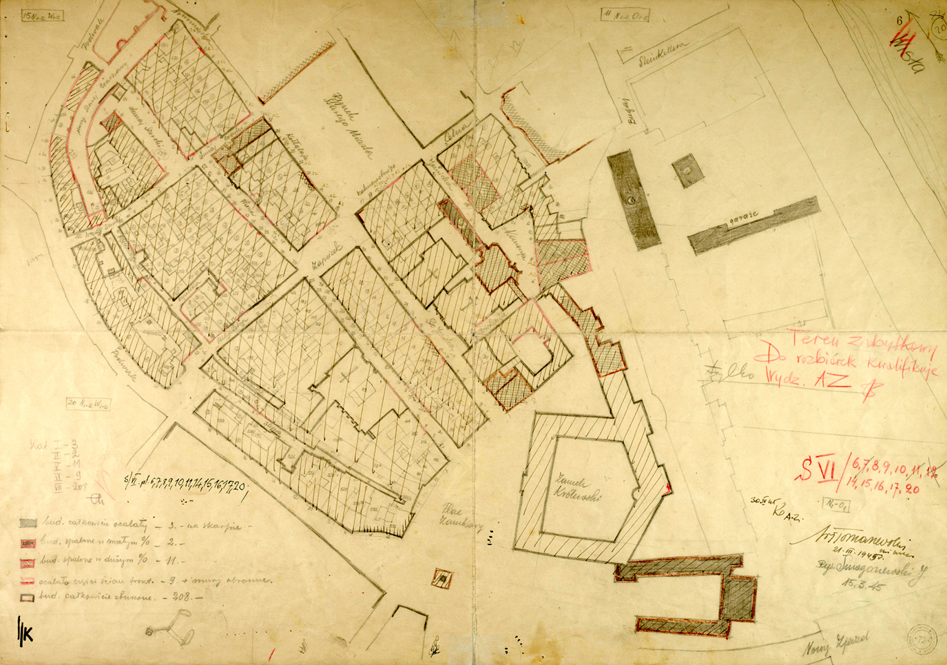
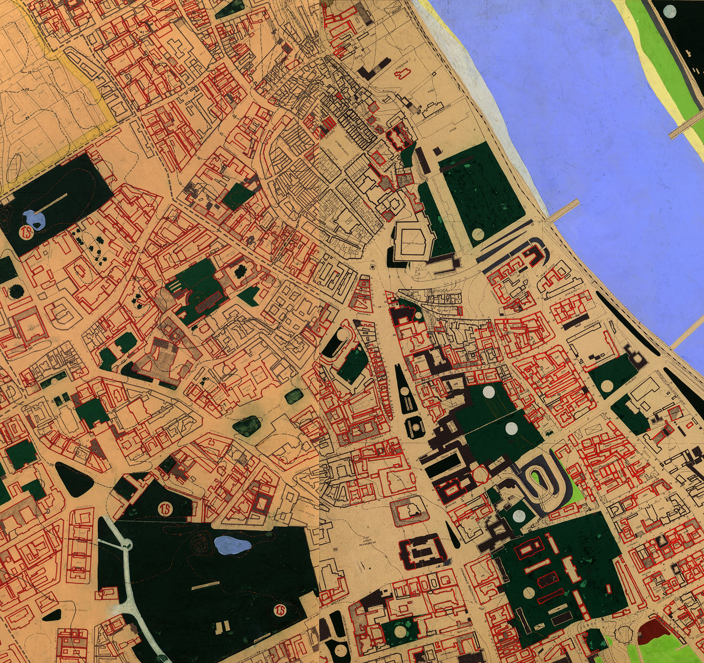
BOS mapped damage in Warsaw at different scales and levels of detail. An entire report on the typology of barricades in the city, a plan showing the location and future disposition of rubble and a huge map of damaged green spaces in the metropolitan area attest to a commitment to documenting diverse aspects of the city's ruinous state.Footnote 58 Apart from the Nazi-organized Jewish ghetto in Warsaw, which was mapped only very selectively,Footnote 59 the BOS Department of Surveys and Statistics (Wydział Inwentaryzacji i Statystyki) mapped the entire city centre, including immediate suburbs, at a scale of 1:1,000, and treated historic areas with particular care. Co-operating with the Department of Historic Architecture, it deployed groups of specialists to map the Old Town as well as the Royal Route, including the churches, historic royal residences and palaces of the aristocracy found along it. Detailed maps of historic city blocks made in situ were marked with the department's acronym ‘AZ’, and included an instruction forbidding demolition without the department's consent (see Figure 1). These were subsequently collated, scaled down and copied in the office, producing an exhaustive 1:2,500 damage map of the entire metropolis (see Figure 2).
Damage map of the Old Town of Warsaw, 21 March 1945. Original scale 1:1,000. State Archives in Warsaw (Archiwum Państwowe w Warszawie, APW), Capital Reconstruction Office (Biuro Odboudowy Stolicy, BOS) 6986/20.
Damage map of the historic city centre of Warsaw showing the Royal Route extending to the south-east of the Old Town, 1945–(?). Detail of plates 31 and 32. Original scale 1:2,500. APW, BOS 1040.
BOS augmented initial surveys with a broad range of drawings – from archaeological studies of ruined buildings to functional traffic diagrams – all produced with a view towards homogenizing the historic urban ensemble, adapting it to a new vision of modernist, and after 1949, socialist Warsaw.Footnote 60 Two diagrams, published in 1956 by Piotr Biegański and Jan Zachwatowicz in their book The Old Town of Warsaw: A Reconstruction, are striking examples of the confluence between heritage, modernist and Stalinist planning. Set out amidst detailed archaeological surveys of masonry, the diagrams position the Old Town as a crucial node within the traffic plan for greater Warsaw and as a key element of the socialist realist city (see Figures 3a and 3b).Footnote 61 With a view cone connecting the Old Town to the newly constructed Joseph Stalin Palace of Culture and Science (Pałac Kultury in Nauki im. Józefa Stalina),Footnote 62 the dialectic synthesis between the Polish kings and Soviet dictators, and indeed Polish and Soviet architectural history, is made to exist uncomfortably in a rational, functionalist interpretation of contemporary urbanism.
Diagrams locating the Old Town of Warsaw in relation to arterial roads (a) as well as the Palace of Culture and Science (b). After P. Biegański and J. Zachwatowicz (eds.), Stare Miasto w Warszawie: Odbudowa (Warsaw, 1956), personal collection of J. Elżanowski.

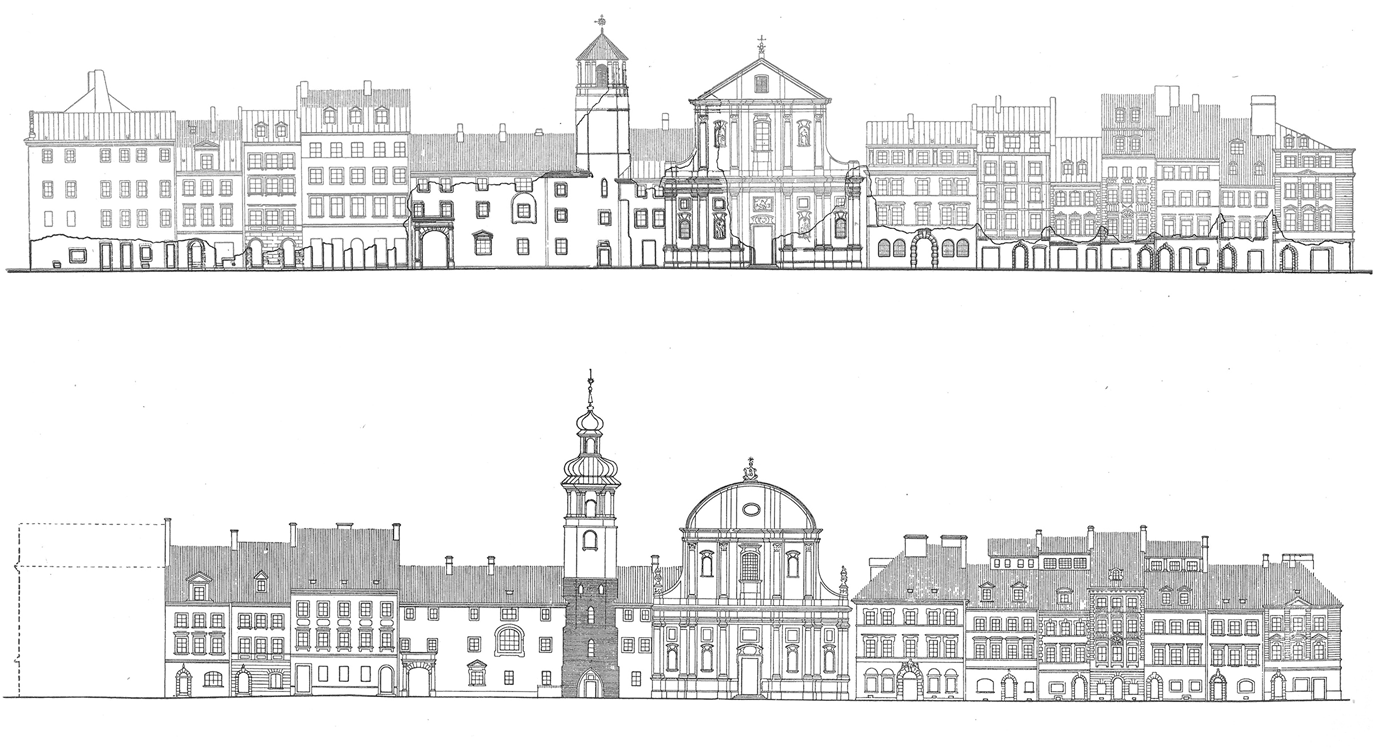
The publication, distributed to celebrate the completion of the Old Town, expertly links the scale of the region, neighbourhood and building, showing the reconstruction of the historic city centre as a precise and complete scientific endeavour, expressed graphically in the language of modernist urbanism. Here, archaeological damage surveys become integral to the design process itself: plans, sections and elevations of ruined buildings are juxtaposed with reconstruction drawings, highlighting the radical changes in the form and function of the neighbourhood within the urban organism. Courtyard buildings are cleared, façades and rooflines altered, corner buildings replaced, church towers entirely redesigned (see Figure 4). Bounded by the partially reconstructed, and partially invented, late medieval city walls and gates, the Old Town is made to resemble the discreet urban node that the diagrams show it to be.
Elevation of Piwna Street in Warsaw based on surveys conducted in 1939 and after 1944 (top), juxtaposed with as-built drawings from 1956 (bottom). After Biegański and Zachwatowicz (eds.), Stare Miasto w Warszawie, personal collection of J. Elżanowski.
The question of exactly when the Old Town became conceptualized as a separate cartographic and planning entity with national symbolic significance (eventually gaining its iconic status as a UNESCO World Heritage reconstruction in 1980) deserves in-depth scholarly attention elsewhere; however, we offer a brief summary here. A look at successive regulatory plans for Warsaw shows that the legend category ‘Old Town’ appeared for the first time in the ‘General Plan for the Capital City of Warsaw’ from 1931.Footnote 63 Concurrently, Jan Zachwatowicz initiated an extensive restoration and reconstruction project of Warsaw's medieval city walls, physically disengaging the Old Town from the nineteenth-century fabric that had grown up around it.Footnote 64 The category ‘Old Town’ continued to exist on the German wartime street map of the Polish capital, and was certainly the staple of the 1940 Nazi plan for reducing Warsaw to a small colonial outpost.Footnote 65 Despite the fact that the category did not appear in early post-war master plans for Warsaw, by the late 1940s, the reconstruction of the Old Town had become a central trope in an odd confluence of socialist realist and functionalist planning that combined restoration and modern housing.Footnote 66
Not only did Polish conservationists, such as Zachwatowicz, see value in functionalist planning generally,Footnote 67 they even framed their own archaeological mapping within the functionalist logic of corridors, nodes and zones.Footnote 68 The Old Town was reimagined as a discreet heritage zone, connected to a historic corridor running south to include the Royal Route and former royal residences. This linear layout conformed to inter-war functionalist preoccupations with a north–south axis, following the natural meanderings of the city's post-glacial escarpment, and intersecting with an east–west thoroughfare in the area of the Old Town.Footnote 69 Steeped in picturesque imagery, and dialectic to the core, the Old Town was placed at the head of an urban ensemble filled with socialist institutions housed in the reconstructed urban palaces of aristocrats and industrialists barely erased from Polish history.
In his introduction to The Old Town of Warsaw, Biegański writes that ‘the problems of contemporary urbanism, transposed onto historic ensembles, have put professionals in the position of considering many questions, including those which, prior to 1944, did not pertain to conservation’.Footnote 70 Indeed, wartime destruction required conservators to respond to unprecedented questions regarding the rearticulation of entire historic districts. But, whereas Biegański identifies 1944 as the moment of a paradigmatic shift in architectural conservation towards planning, our argument here is that conservation has long been intertwined with urban mapping and planning techniques deployed over large urban areas. Those mapping Warsaw's Old Town implemented toolkits already developed in the late nineteenth century to collect information about entire districts.
A comparative look at Munich's damage assessment and planning strategies for its historic city centre confirms our hypothesis. Just like in Warsaw, Munich's post-war symbolic and physical reconstitution – gradually implemented by Theodor Fischer since the early 1900s – relied on ‘pruning’ tools popularized by Giovannoni after 1913 and on functional zoning strategies borrowed from Baumeister and Stübben. As such, the practice of mapping damaged historic architecture in both Warsaw and Munich sits squarely within the history of the development of techniques to record, visualize and thematically map their historic fabric for planning purposes. The following section outlines the history of Munich's damage cartography in relationship to the creation of a new ring road as a boundary for the Bavarian capital's heritage district.
Damage assessment and the creation of Munich's Altstadt
In spring 1946, the head of Munich's Planning Department (Stadtbauamt-Stadtplanung), Karl Meitinger, published a brochure entitled New Munich (Das neue München). The booklet contained a summary of his work surrounding the planning and post-war rebuilding of Munich, with a particular focus on the historic city centre. As a former member of the Nazi party, Meitinger was forced to retire from his influential post the same year his book was published, leaving behind a controversial legacy of urban development plans based on a complex combination of inter-war studies and post-war damage assessments. This section outlines the ways in which Meitinger used and misused damage cartography to promote the creation of a distinct, central heritage zone bounded by a newly cleared ring road that roughly follows Munich's former fortifications.
Based on the popular rhetoric that war damage offered a ‘unique opportunity’ for renewal, Meitinger suggested the creation of 16 break-through conditions around the city centre, connecting the historic core to the newly planned ‘parking-and-traffic ring’.Footnote 71 His 64-page brochure, issued with the consent of the American Military Government, was the first publication to include a damage map of Munich.Footnote 72 Based on a 1:1,000 scale detailed damage survey of the city (Schadensplan der Altstadt) prepared in 1945, Meitinger created a subsequent 1:7,000 scale hybrid damage and development plan. With a delicate purple hatch, the drawing literally crosses out buildings coded with various levels of destruction (see Figure 5).
Bomb damage map of Munich's historic city centre (Altstadt), Department of Planning (Stadtbauamt – Stadtplanung), January 1946. After K. Meitinger, Das neue München: Vorschläge zum Wiederaufbau (Munich, 1946).
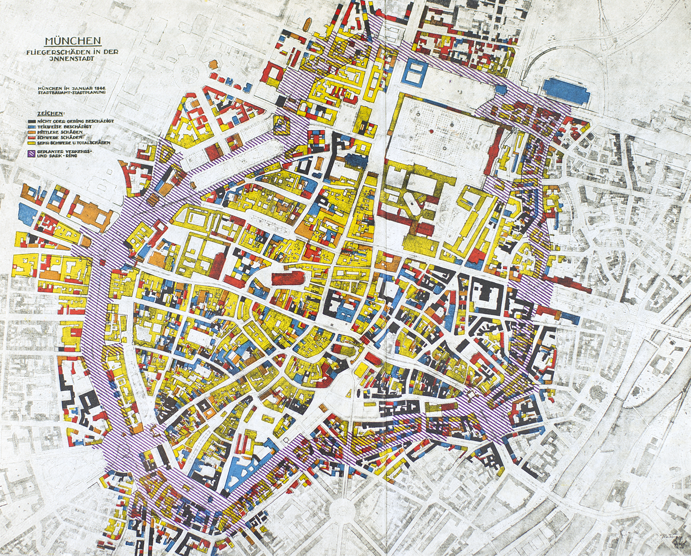
At first glance, Meitinger's hybrid plan seems to present the results of consistent and transparent planning: seriously damaged areas, objectively recorded and mapped by architects, enable the introduction of missing infrastructure, specifically the long-desired ring road; however, upon closer examination, the map reveals a different story. Especially in the south and east ends of the city centre, the new ring road crosses areas marked as relatively intact, suggesting that the road was never a straightforward response to damage assessment. Instead, as the archival documentation shows, damage maps were used to legitimize pre-war plans for the demolition of the surviving built fabric.
As early as 1928, Munich's Planning Department proposed a ring road as a way to facilitate automobile access around the city centre without affecting the perceived historic and artistic integrity. The plan gathered dust until the late 1930s, largely as a result of difficulties with land expropriation. In 1938, Nazi authorities briefly resuscitated the project,Footnote 73 but protests following the demolition of the church of St Matthäus halted progress. By the time Meitinger joined the Nazi party in 1939, and was nominally put in charge of city planning, Hitler's focus had shifted away from the city centre, towards an over-scaled suburban axis. Left with little influence, Meitinger continued to work on plans for a ring road in secret.
The idea of the ring road officially re-emerged as a public project in 1945, and then continued even beyond Meitinger's early post-war leadership of the Planning Department. In his 1946 brochure, Meitinger claimed that building was not a private affair but rather a public concern.Footnote 74 Accordingly, he used the hybrid damage and development map as a tool to convince the public, politicians and his colleagues of the unique possibility to introduce a system of modern traffic routes that would bypass the Altstadt, allowing for its restoration as a place connecting Munich to its medieval history. At the same time, he deployed the original Schadensplan der Altstadt as a working tool to negotiate the transformation of specific damaged quadrants into the nodes of a modern heritage zone.
The Schadensplan der Altstadt (see Figure 6a) – which included a characteristic blue outline delimiting buildings and blocks identified by the Bavarian State Office for the Preservation of Historical Monuments (Bayerisches Landesamt für Denkmalpflege, BLfD) as having particular historic value – documented damaged and surviving buildings for the four districts that collectively formed the historic city centre. By showing surviving walls and intact ground floors, the map offered three-dimensional data of near-archaeological quality. This detailed and dense information, which created the basis for decisions about demolition and reconstruction, can be interpreted as a form of preliminary heritage recording. It allowed for heritage buildings to be selected and protected in anticipation of clearance and reconstruction work. With extremely limited funding, and at the cost of emergency housing measures, the city council paid for the restoration of all the surviving medieval city gates – symbolic cornerstones for the construction of a new heritage district, and the reconstruction of Munich as a whole. Interestingly, the plan gave less attention to both damaged and intact buildings in the areas of the intended ring road.
Selection of damage maps and development plans showing a quadrant of Munich's Altstadt in the area of today's Promenadeplatz, 1945–53: (a) Schadensplan der Altstadt, 1945; (b) reconstruction development plan, n.d., likely 1945; (c) process map layering damage with ongoing reconstruction continuously compiled until September 1953; (d) reconstruction survey, 1953. State Archives in Munich, Plansammlung-Stadtplanung: PS-SP-126-NO-I-1_v; PS-SP-59; PS-SP-0115_NO-I-1-v-a; PS-SP-0115_ NOI-1-21.
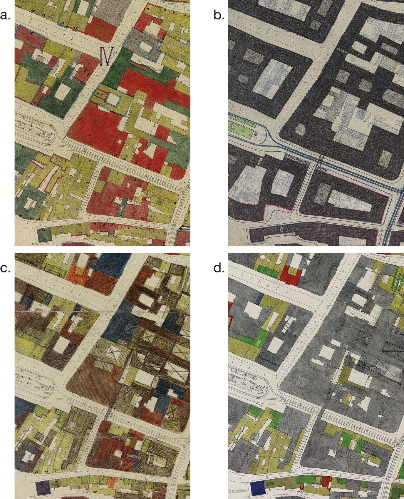
Munich's city council was serious about its commitment to restoring and restructuring the Altstadt. Preparatory work began in the summer of 1945 and lasted until the end of 1951, when the last rubble collection site in the city centre was cleared. The work of rebuilding can be divided into a preliminary damage assessment phase (1945), an intensive rubble clearance phase (1946–49) and a more active reconstruction phase involving private owners (starting with the currency reform in June 1948). Despite a lack of qualified employees,Footnote 75 by the autumn of 1945 the Planning Department had compiled numerous specialized damage maps, and produced a remediation and development plan for the historic city centre (see Figure 6b). Implemented only in part, the plan suggested a combination of rebuilding and clearance, including the restoration of historic monuments and the widening of selected streets to allow for the passage of automobile traffic generated by the new ring road.
In addition to private owners, who remained responsible for the reconstruction and restoration of single buildings, the city council, working with the Planning Department and the BLfD, made a considerable public contribution to rebuilding by clearing rubble and other debris from the city centre, and by repairing technical infrastructure. Starting in May 1946, specialists formerly responsible for fire prevention used hand pulley blocks to carefully tear down unstable and dangerous walls, as labourers removed all remaining rubble with bulldozers. Engineers then stabilized stone façades left vulnerable by the destruction of interior wooden structures. During this demolition and stabilization process, the BLfD compiled detailed damage surveys, reported on the state of listed buildings and monitored valuable architecture during the rubble clearance process.
Private reconstruction began in earnest only in the summer of 1948, after the city council had completed most of the clearance work, and persisted in parallel to the phased construction of the ring road. During this time, the Planning Department continued its practice of mapping the Altstadt, continuously updating its damage surveys until 1953. Figure 6c demonstrates how tonal gradation allowed for a damage map to double as a planning tool. Since lighter colours were used to show heavy damage, and darker colours to indicate minor damage or intact buildings, sites requiring attention could easily be hatched black following reconstruction or development.Footnote 76 Figure 6d, in turn, shows a fragment of a nearly complete reconstruction map – a palimpsest of damage and rebuilding that graphically communicates the complexity of the post-war urban structure.
The ring road, initiated in parallel to the rebuilding of the Altstadt, was finished only in the 1960s. While its planning was not connected to specific damage zones, functionally it created the conditions for the extraction and articulation of a heritage zone within the city. Together with the new break-through conditions, widened street sections and reconfigured squares, it produced a system of thresholds and controlled entry and exit points that acted like a city wall. Within this zone, archaeological mapping performed for planning purposes was correlated with the preservation and reconstruction of buildings and façades that the head of the BLfD, Gerog Lill, saw as historical nodes anchoring post-war Munich to its imagined medieval history. Damage maps made in Munich throughout the 1940s and 1950s show how the conjoined work of rubble clearance, planned demolition and meticulous reconstruction led to a modernized cityscape anchored in a newly articulated Altstadt zone.
Conclusion: from mapping to heritage-making
Relying on the optics of scientific precision, damage maps made in Warsaw and Munich throughout the 1940s and 1950s suggest a comprehensive, objective and neutral representation of the state of the built fabric after World War II. Within this analytical mindset, a contemporary reader might presume a series of axiomatic correlations: all of the buildings in the city were surveyed with equal precision; buildings marked as damaged were the result of wartime violence; destroyed areas were meant for clearance and new construction; and post-war demolition and ongoing clearance processes were not shown. And while damage maps certainly emerged from precise analytical surveys, as working documents prepared by professionals implicated in complex and fast-paced negotiations, they need to be read with a constructivist eye in order to decipher the layers of meaning that often fly in the face of initial assumptions.Footnote 77
Instances of divergence between cartographic representations and the actual post-war state of buildings abound in the cases of Munich and Warsaw outlined above. The paths taken by Munich's ring road, as well as the areas occupied by perimeter parks and transverse roads in Warsaw's Old Town, cannot be reliably correlated to total damage. Both in Munich and Warsaw, destroyed buildings were rebuilt from scratch whereas neighbouring intact buildings were sacrificed to development. In the particularly complex example of Warsaw's Nazi-organized Jewish ghetto mentioned earlier, BOS initially excluded the area from the city-wide damage survey, and mapped it selectively only prior to complete redevelopment. The cartographically neglected ghetto provides a particularly stark contrast to the neighbouring Old Town, meticulously mapped just a few hundred metres away.
Despite its shortcomings and propagandistic intent, damage cartography, including its most precise archaeological subset, provided the data necessary to make informed decisions about the size, scale and feasibility of particular post-war urban design and planning strategies. The boundaries of Warsaw's historic core are the result of negotiations that took place throughout the late 1940s between experts in conservation, urban design, urban planning and sociology, and the communist political elites. The idea to restore a small Old Town, linking it to a long corridor of historic parks and residences woven through the city, speaks to the ultimate success of archaeological mapping deployed in combination with functionalist planning principles. In Munich, damage mapping similarly mediated between urban sanitization and architectural conservation interests.
Both case-studies lead to analogous conclusions about the relationships that existed in the early post-war period between the coeval and entangled processes of damage mapping and the production of heritage. Even before demolition and reconstruction plans were drawn and implemented, damage survey strategies deeply affected decisions about what to demolish and what to rebuild. Without emergency survey missions, buildings could neither be protected from the elements nor lobbied for during political negotiations. While mapped buildings did not necessarily have a larger chance of surviving urban clearance, unmapped buildings effectively ceased to exist. Mapping was thus a way to ensure that damaged architecture – whether historic or not – presented considerable material resistance to an imagined post-war tabula rasa.
Building on emerging scholarship in damage cartography, and based on the case-studies of Warsaw and Munich summarized in this article, we have shown that damage maps not only recorded existing states of ruination, but also projected desired states of urban clearance. Far more than neutral visualizations of a singular state of destruction, damage maps were working documents, continuously updated to serve as base drawings for post-war plans. In Munich, Warsaw, London and in numerous other cities throughout Europe, damage surveys and maps simultaneously recorded World War II destruction, ongoing demolition and future clearance, blurring the boundaries between surveying, mapping and planning.


 Open access

