

Introduction
As a late-coming empire, Japan’s fast-paced activities in the Asia Pacific are best known as a history of plunder and subjugation of weaker peoples.Footnote 1 A conspicuous departure from this simplistic generalization is Japan’s policy toward Muslims, in whom the “Rising Sun” invested more rapport-building and good will than determined firepower to wreck and burn. This departure recalls Imperial Germany’s amity towards the Ottomans and the Balkan Muslims under Emperor Kaiser Wilhelm II, who once earned the sobriquet of “hajji Wilhelm” in local Arab newspapers when he traversed Istanbul and the Middle East.Footnote 2 Perhaps a more poignant comparison is with Nazi Germany, which presented itself as a friend of Islam after the German army landed in Tripoli in February 1941, and for the rest of the war recruited Muslims into the ranks of its army as well as the notorious Schutzstaffel (SS).Footnote 3 On Japan’s part, akin to its Axis partners in Europe, it also engendered a “Muslim Policy” by funding research on the Muslim world, establishing mosques in Tokyo and several other big cities such as Kobe and Nagoya, and sheltering and sponsoring the activities of Muslim independence fighters such as the well-known Tatar Abdurresid Ibrahim.Footnote 4 Short of officially funding Muslims’ military struggles, imperial Japan nonetheless cultivated and onboarded local Muslim allies in Sumatra, Malaya, and North China.Footnote 5
Imperial Japan’s interest in onboarding Muslims in China was situated at the convergence of its “continental policy” aimed at thwarting Chinese claims to a territorial totality cemented by the foregoing Qing Empire, and its Muslim policy, which sought to extend Japan’s sphere of influence well beyond East Asia to include the Arab world, Turkey, Southeast Asia, and Afghanistan.Footnote 6 Regarding its “continental policy,” the ever so erudite Owen Lattimore, in an essay colorfully titled “The Kimono and the Turban,” wrote, “All the most famous conquests of China have been the result of a double process: the forming of non-Chinese coalitions along the Great Wall frontier and the break-up, simultaneously, of Chinese coalitions within China … Japan’s ‘continental policy’ is an attempt to revive this process in a modern setting.”Footnote 7 Whereas Lattimore’s use of the term “coalition” may appear overly egalitarian, this article adopts the corporatist verb “onboard” to highlight the asymmetrical distribution of agency within such alliances. The corporatist dynamics of a “coalition of the willing” in contexts of conquest and political entrepreneurship were first identified by Frederic Wakeman in his seminal work The Great Enterprise. Footnote 8 Building on this insight, Mark Elliott showed how military successes and territorial expansion gave rise to a multiethnic military caste institutionalized in the Manchu Eight Banners.Footnote 9 More recently, David C. Porter has revisited the Qing Eight Banner System in times of peace, exploring how what I term the corporatist logic of onboarding junior partners was not only vital for augmenting the Qing court’s power during wartime, but also essential for asserting its authority in quieter periods of rule.Footnote 10 In this light, the concept of political onboarding offers a productive analytical lens for understanding Japan’s relationship with its various junior partners in the imperial project of Pan-Asianism.Footnote 11 It captures the partnership as a form of political entrepreneurship and encapsulated interests—adventurous and aspirational for all parties involved—without retrospectively imposing a moral binary of collaboration versus resistance.
Newer studies have shown how the Japanese Empire encouraged local social and ethnic groups across East and Southeast Asia to reinterpret and reshape the imperial structure through their own cultural, political, and economic frameworks, treating imperial expansion as an opportunity to get onboard a new “social mobility complex.”Footnote 12 Crucially, this wave of scholarship has not sought to rehabilitate Japanese imperialism or deny its violence. Rather, it seeks to move beyond moralistic readings of collaborators and imperial agents as deluded. By taking the aspirations and agency of these actors seriously, recent research has begun to unpack the appeals of the Greater East Asia Co-Prosperity Sphere, as well as its limitations. This approach is also shedding new light on how competing imperialisms interacted and clashed in contested borderlands such as Inner Mongolia and Xinjiang, where Japanese, Chinese, and Soviet visions of modernity and empire overlapped.
It is notable that Lattimore predicted that Japan’s policy on China’s northwestern borderland was “heading for disaster” because he deemed that the millions of Chinese Muslims there could not “be pried off to make a pro-Japanese state.”Footnote 13 In other words, the onboarding of Muslims in China would fail because they were not interested in partnering with Japan. This top American advisor for the Chongqing-based Republic of China regime, however, quickly contradicted himself by undercutting the agency of northwestern Muslims, writing, “The geography of the oasis is the symbol, in fact, of a permanent tendency toward excessive regionalism and partition into small, independent groups,” while noting that Islam was never able to congeal the region together “quite closely enough to make possible a permanent Muslim State.”Footnote 14
Although Lattimore’s ecumenical foreclosure of a pro-Japanese Muslim state in northwest China was borne out by history, his essay, written in May 1938, does not show us what concrete, disastrous actions Japan took in its attempt to create such a state. To the modern reader, the blueprint insinuated in Lattimore’s essay could sound more like speculation, given that Japan did not follow up in Xinjiang with a pro-Japan state even though the “North of the Great Wall non-Chinese coalitions” had two successful precedents in Manchuria and Inner Mongolia.Footnote 15 Nor does he prove that imperial Japan necessarily shared his analysis of oasis regionalism and Islam’s shortcomings. Those ostensible shortcomings, even if true, should not have stopped Japan from making multiple friends, if not a singular friend, in Xinjiang. The Soviet Union, for instance, did not shy away from doing exactly that.Footnote 16 In fact, stories from far afield attest to Japan’s reputation as a friend of Islam and its being seen as presenting a viable model for Muslim peoples to achieve “modernization without Westernization.”Footnote 17 Turkish nationalist feminist Halide Edib was so inspired by Japan’s defeat of Tsarist Russia that she named her son Togo.Footnote 18 Like Abdurresid Ibrahim, another Russian Tatar Muhammed Gabdulkhay was also enamored with Japan’s hospitality toward Muslims. The two men led the Tatar exile community in Japan and launched their Idil-Ural Tatar movements against the Soviet Union.Footnote 19 Even as the occupying power in Java, Japan was able to marshal enough friends among Muslim nationalists there to maintain effective control.Footnote 20 Conclusively, Japan’s imperial ambition was not locked into its desire to divide and dominate a stumbling China; it looked further south to the Indian Ocean rim and the Pacific, and sought less formal connections in continental Asia such as with Afghanistan and Turkey.Footnote 21 By drawing on new archival sources, this article reveals that even as Tokyo showed keen interest in Western Asia, it did not overlook the vast territory of Xinjiang in its pursuit of geostrategic alliances with Muslims across the globe. Xinjiang’s importance lay precisely in its embeddedness within the broader Muslim world. Only belatedly did Japanese strategists come to recognize that both Xinjiang’s Muslim population and its geography would play a decisive role in shaping Japan’s imperial fortunes during World War II—a realization that has largely escaped scholarly attention. This historiographical oversight stems from the failure to situate Japan’s engagement with Xinjiang within a world-historical framework. As the following analysis demonstrates, by the later stages of the war, the American-Chinese-Soviet alliance had effectively turned Xinjiang into a “pivot,” to borrow a different term from Lattimore.Footnote 22 If Japan succeeded in cutting off the Allies’ supply lines that ran through Burma, it would still have to contend with materiel flowing through northwest China. Tokyo ultimately chose not to invade Xinjiang, opting instead to monitor the region as part of its effort to coordinate imperial expansion and consolidation in Manchukuo, a decision that came at a great cost.
The reluctance to resort to military force was nevertheless accompanied by a notable attentiveness to ethnological understandings of the region’s indigenous populations. While the effort to construct a political demography in Xinjiang ultimately remained aspirational, it displayed a desire to tether indigenous sovereignty to the authority of the colonial state, bypassing Chinese dominance. As Prasenjit Duara argued in his study of Japanese ethnography among the Oroqens in Manchukuo, this impulse reflected a broader historical trend: the emergence of a new “world culture” wherein “imperialism came to be penetrated by nationalist rhetoric, forms and practices,” by which he meant that imperial formations sought to co-opt and re-purpose ethnic nationalism—however latent its forms—within their own projects of domination.Footnote 23 What we see in Xinjiang is a local manifestation of this global phenomenon.
The Challenge in Onboarding Turkic Peoples from Turkestan
Japanese encounters with Xinjiang began with a measured and clear geopolitical interest. According to Noda Jin, Baron Nishi Tokujirō 西德二郎 (1847–1912), famous for his role in negotiating the 1889 Nishi-Rosen Agreement as the Foreign Minister under Itō Hirobumi, was the first Japanese traveler to set foot in Xinjiang.Footnote 24 In the wake of the Russian occupation of Ili in July 1871, St. Petersburg-trained Russologist Nishi decided to return to Japan in 1880 from his diplomatic post as the extraordinary chargé d’affaires in St. Petersburg. On the way he stopped over in Ili, being curious about the ongoing Russo-Qing territorial dispute and the strength of the Qing garrison.Footnote 25 Subsequently, Japanese agents were able to move around in Ili using Russian-issued passports (旅券). Noda suggests that the Japanese agents were keenly following the negotiation of the evacuation of the Russian troops from Ili, which resulted in the St. Petersburg Treaty in 1881, to inform Tokyo’s timing and course of action with regard to annexing the Ryūkyū Kingdom.Footnote 26 Following Japan’s victory in the Russo-Japanese War in 1905, its agents were able to penetrate Russian Turkestan via a torturous route through Siberia and western Mongolia.Footnote 27 In the meantime, Japan also maintained an interest in northern Xinjiang as part of a deal to share intelligence with the British Empire under the auspices of the Anglo-Japanese Alliance, in effect from 1902 until 1921. Notably, Japan missed the opportunity to make inroads into the Muslim-majority Tarim Basin due to the way the Alliance divided responsibilities between the two allies: British intelligence operations oversaw the southwest of Xinjiang centered around Kashgar, while Japan was tasked with investigating the Ili region, Khovd, Uliastai, and Ulaanbaatar.Footnote 28
The classified “Xinjiang Inspection Report” (新疆視察復命書) that resulted from this espionage was published in 1907 by Tōa Dōbun Shoin (East Asia Common Culture Academy) under the aegis of the General Staff Headquarters of the Ministry of Army 陸軍參謀本部 (hereafter the GSH).Footnote 29 Its first section documented Russian influence in Urumqi, Ili, and Tarbagatai, and particularly the presence of Cossack troops. The report’s second section recorded the activities of Russian passport holders, including agricultural settlers, merchants, and Muslims from western Turkestan. The third section provided an overview of the postal system, transportation, and other urban infrastructure, while a final section engaged in some basic ethnology that distinguished between the Chinese-speaking Dungan Muslims and the majority Muslim group—the Turkic people 土耳古人.Footnote 30
According to Ōno Ryōsuke, more intense intelligence gathering took place when the GSH dispatched several military officers to Urumqi, Ghulja, Tarbagatay, and Kashgar in the aftermath of the October Revolution, wherein Japan was an active supporter of the White Russians. In what was known as the “Siberian Intervention,” Japan sent large numbers of troops to Siberia to fight against the Red Army. In this context, espionage in Xinjiang helped to monitor developments of the White Russians and their Cossack allies in Turkestan.Footnote 31 Ōno’s study found that in late 1921 the Ministry of the Army earmarked a monthly expense of 5,600 yen for its Mongolia-Xinjiang espionage apparatus. From this, 7,259 yen, or US$3,506 in 1921 terms (US$62,637 today after inflation adjustment), was spent by its Urumqi cell between October 1921 and March 1922.Footnote 32 Interest in Xinjiang arguably subsided for the remainder of the 1920s due to the extreme unpopularity of the Siberian Intervention, which claimed the lives of some five thousand Japanese soldiers and embroiled the Japanese army and government in bitter disagreements throughout the decade.Footnote 33 Beginning in 1931, Japanese interest in Xinjiang was reignited due to widespread Muslim unrest in the Tarim Basin, from which emerged the Eastern Turkestan Islamic Republic, centered around Kashgar, which lasted only a few months, from November 1933 to the following spring.Footnote 34 The Kwantung Army based in Manchuria, in the wake of founding the Manchukuo in 1932, also took serious interest in forming an “Anti-Communist Ring” that would extend from Manchukuo and Inner Mongolia all the way to Afghanistan via the Muslim belt of northwestern China.Footnote 35 Despite an obvious desire to “carve out a role in the Great Game of the early twentieth century,” Japan seems to have found little success in cultivating allies among the indigenous Turkic people.Footnote 36
That is not to say Japan did not recognize the value in gaining Turkic voices sympathetic to its aims, but those onboarded by Japan were by and large of external origins. Noriko Yamazaki, quoting from Komatsu Hisao, suggests that Ibrahim, the Russian Tatar who self-identified as a pan-Islamist Turk and was a long-time friend to Tokyo’s Muslim Policy circles, visited Xinjiang around 1922, and was in some way involved with the First Eastern Turkestan Islamic Republic.Footnote 37 Ōno also points out that Japanese agents had frequent contact with the Ottoman educator and political activist Ahmed Kemal Ilkul in Kashgar between 1914 and 1917, when he was arrested and detained in Urumqi. Following his release in 1919, Ilkul taught two Japanese officers Chagatai.Footnote 38 Japan’s only known indigenous contact from Xinjiang was a Torghut Mongol, Balta Tura (1882–1920), who studied at Tokyo Shinbu Military Academy.Footnote 39Aside from reconnaissance, Japanese explorers also participated in what Sven Saaler calls “the second age of discovery,” resulting in an academic field of Turkology in Japan.Footnote 40 According to Klaus Röhrborn, when Japanese began to undertake expeditions into Central Asia they were partly motivated by a quest to discover the region’s pre-Islamic—that is, Buddhist—past rather than its Islamic present.Footnote 41 Ōtani Kōzui (1876–1948), the Kyoto-based Buddhist abbot and a member of the British Royal Geographical Society, twice financed his students to visit the oasis settlements around the rim of the Taklamakan desert, in 1908 and in 1910.Footnote 42 Those explorations took his disciples to Lop Nur, Loulan, Khotan, Niya, Keriya, Kucha, Kashgar, and Yarkand.Footnote 43 Expeditions between 1912 and 1913 were led by Tachibana Zuichō 橘 瑞超 (1890–1968), who transcribed and published the discoveries he made in Xinjiang, including a fragment of a Uyghur translation of the ōAmitāyur-dhyāna-sūtra (觀無量壽經 Guan wuliang shoujing).Footnote 44 A comparable amount of scholarly energy was devoted to studying the ancient Turk tribe, apparently spurred by an archaeological discovery of Turkic runes in the Temiya Cave in Hokkaido.Footnote 45
Difficult as it is to disentangle such ventures from imperialism, particularly scientific imperialism, the Japanese exploration of Xinjiang’s past should be understood in terms of Japan’s desire to compete with similar and contemporaneous global entities in uncovering unknown places and pasts.Footnote 46 What bears noting here is that although the stories of Western explorers such as Sven Hedin and Ferdinand Freiherr von Richthofen are well-known to historians, it is often forgotten that in the early twentieth-century international exploration of Xinjiang, Japan, too, made its mark.Footnote 47
By and large, however, imperial Japan formulated no distinct “Xinjiang policy” until the early 1940s, contrary to what Lattimore prematurely suggested in May 1938. Published Japanese sources treated Xinjiang either as an underexplored site of archaeological riches, with the potential to elevate Japan’s status among its Western peers in a competitive scientific imperialism, or as an uncertain place of geostrategic concern. This differed from what the area meant for the three better-entrenched powers—Great Britain, the Soviet Union and successive Chinese frontier state-makers.
Much of Japan’s interest in Xinjiang was coordinated to help with its geopolitical moves further to the east, whether the annexation of the Ryūkyū Kingdom in 1881, or the insulation of Manchukuo from the Soviet Union in 1932.Footnote 48 Keeping the Soviet Union at bay in Manchuria was of utmost importance to Japan’s prudence in Xinjiang in the 1930s. This was because in the late 1930s the Japanese army engaged Soviet forces on multiple occasions along the Mongolian-Manchurian border. In the Battle of Khalkhin Gol in 1939, the Soviet-Mongolian forces won decisively, which eventually forced Japan to return to the negotiation table and sign the Japanese-Soviet Non-Aggression Pact in April 1941.Footnote 49 That neutrality pact essentially ensured that Japan would do little more than watch closely as the Soviets made big inroads in Xinjiang by propping up de facto dependencies such as the Sheng Shicai regime in 1934, and in 1944 the Ghuljia-based Second East Turkestan Republic. This “watchful observer” stance dramatically shifted with a new geopolitical alignment in the region, when Allied countries united in the common cause of defeating Japan. That forced Tokyo to come up with a Xinjiang Policy, albeit belatedly.
Tipping the Balance: The Allied Powers Threaten from an Unsecured Western Flank
Muslims and Muslim territories have rarely been analyzed as a major factor in deciding imperial Japan’s fate in World War II, with the tangential exception of the Cairo Conference held on 27 November 1943. Another, subsequent Cairo Declaration placed massive political pressure on the Japanese army in the China Theater. The tripartite alliance among Chiang Kai-shek, Franklin D. Roosevelt, and Winston Churchill was the keystone of the American “China-Burma-India Theater” (CBI) strategy, which envisioned the defeat by attrition of Japan’s China Expeditionary Army of over a million soldiers. A famous feature of this strategy was the construction of the Ledo Road through Burma to supply the faltering Chinese regime in Chongqing via the mountainous Yunnan-Guizhou Plateau. When that failed, critical supplies were flown in from India over the Himalaya mountains, via a route known as “The Hump.”Footnote 50 Although the CBI strategy found limited success after the falls of Rangoon in March 1942 and northern Burma that April, politically it ensured that Allied aid was ready to help Chinese resistance, both by nationalists and communists, as soon as an alternative supply route became available.
Such an alternative route had existed before this supply route crisis, but it only became crucial when the Allies struggled to break through Japanese encirclement of China from both the southeast and the southwest. This alternative lifeline had been established to landlocked Chongqing in the northwest after the KMT relocated its power center there in late 1937. Another fall of China’s entire seaboard to Japanese occupation compelled Chongqing to secure foreign aid from both southwestern and northwestern routes. Rey Scott’s 1941 film Kukan offers rare documentary footage of Qinghai’s mostly Muslim soldiers constructing motor roads along the skirts of the imposing Qilian mountains.Footnote 51 Those roads could be mistaken as an endogenous pursuit of modernity by General Ma Bufang, Qinghai’s paramount authority, as American journalist Arthur Doak Barnett observed in 1947.Footnote 52 However, new sources divulge that those constructions were funded by a Chongqing desperate to reach out to the Soviet Union for critical war materiel as early as 1937. Mark Baker found that many local resources were exhausted in constructing and maintaining the “mechanized fossil-fuel infrastructure” that is the Gansu-Xinjiang Highway (甘新公路), which consumed “multiple layers of organic energy inputs” including corvée labor and pack animals.Footnote 53
A similar, albeit more ambitious undertaking unfolded in the northeastern part of the Tibetan Plateau and resulted in the Qinghai-Xinjiang highway (青新公路). On 23 April 1947, the Ministry of Communication approved a proposal to reward and confer honors on Ma Bufang along with nearly seventy other Qinghai officers for their feat of constructing that highway, another crucial artery that delivered international aid from Soviet Kazakhstan to Chongqing.Footnote 54 For Chiang, the Qinghai-Xinjiang to Chongqing Highway promised to improve efficiency since it bypassed the gigantic Qinling Mountain Range. In March 1942, an eager Chiang wrote to the Transportation Control Bureau (運輸統制局), demanding it finish surveying the construction conditions for the Xikang-Qinghai Highway 青康公路 via the grassland of Yushu by the year’s end, and embark on construction the following spring.Footnote 55
Earlier documents confirm that the KMT wanted more international aid, and in larger volume, from the Soviet Union. On 11 November 1941, Ling Hongxun 凌鴻勛, bureau chief of the Tianshui-Chengdu Railway 天成鐵路, apparently in response to a request for information from Chiang Kai-shek, stated that his bureau had completed surveying the railway’s 755-kilometer route, which would cost a staggering annual investment of 85 million yuan for three consecutive years. Ling further stated that the railway would be extended westward with two more lines, one running for 400 kilometers from Tianshui to Lanzhou 天蘭鐵路, and the other an 860-kilometer line from Lanzhou to Suzhou (today’s Jiuquan).Footnote 56 To convince Chiang of the urgency in bankrolling the costly project, Ling pointed out that the oil field in Yumen had dramatically increased its output, which justified spending 40 million yuan to jump-start the construction of that section as soon as surveying was completed.Footnote 57 By June 1944, the northwestern truck route became a busy thoroughfare of transportation activity. The Commission on National Recourses 資源委員會 ordered vehicles carrying aid via Lanzhou, Guangyuan (in Sichuan), Nanzheng (in Shaanxi), and Chengdu to make sure that whenever they had a spare trailer it was fully loaded with tungsten.Footnote 58 Judd Kinzley’s study compellingly shows that, in the years following World War I, tungsten emerged as a critical nonferrous metal essential for high-tech armament production. Xinjiang, especially the Bortala region, became a key supplier in the global market, exporting to not only the Soviet Union but also the United States and Britain, with Chongqing serving as a major transshipment hub.Footnote 59
The volume of international aid coming through the Muslim territories of Soviet Kazakhstan and northwest China was more than just an annoyance for Japan. Baker estimates that between December 1937 and June 1941, Soviet aid arriving via the overland northwestern route averaged 1,000 tons per month, excluding fuel and the weight of donated trucks.Footnote 60 In 1939 alone, 4,400 machine guns, 100 million rounds of ammunition, 250 artillery pieces, 140,000 shells, and 1,000 transportation trucks were delivered to the Chinese Nationalists in Xingxingxia on the Xinjiang-Gansu border.Footnote 61 Although Red Army headquarters in Almaty took care of the section from Saryozek—the railhead town of the Turkestan-Siberia Railway in Kazakhstan—to the Xinjiang-Gansu border, the overall construction and maintenance of the eastern section through the Hexi Corridor bore a clear Muslim imprint, since they were overseen by Ma Buqing 馬步青, brother of Ma Bufang, and his officer ranks.Footnote 62
Direct aid from Moscow shrank dramatically when the German siege of Leningrad began in September 1941.Footnote 63 But Japan’s worry over this unsecured western flank did not stop then, even after the conclusion of the Soviet-Japan Neutrality Pact that year. Just as spring 1942 finally brought the fall of Rangoon, and a few months later the entirety of north Burma, the United States and its KMT allies began drawing up serious plans to revive the northwestern route.Footnote 64 The KMT, now equipped with motorized mobility enabled by the Xinjiang-Gansu Highway, moved central government forces into the Hexi Corridor to replace Ma Buqing’s Muslim army, which was ordered to move to the Tsaidam Basin in northwestern Qinghai.Footnote 65 In the meantime, KMT deputies also entered Urumqi at the invitation of Sheng Shicai, who wanted a rapprochement with Chiang Kai-shek.Footnote 66 The only thing that stopped the Chinese Nationalists, backed by the Americans, from taking full control of the northwestern route was the embattled Soviet Union at the route’s western end. However, the Soviet Union turned against Japan toward the end of 1943. The Tehran Conference effectively nullified the Japan-Soviet Non-aggression Pact, as Stalin agreed in principle that the Soviet Union would declare war against Japan following an Allied victory over Germany. In return, Roosevelt promised Stalin the Kurile Islands and the southern half of Sakhalin. This new, unprecedented configuration brought together a U.S.-Soviet-Chinese alliance against a Japan whose strength was already spreading thin in the wide west Pacific. On a practical level, it meant that, just as Japan stopped Allied war materiel from leaking into the China Theater through Burma, a floodgate of aid threatened to open in its unsecured western flank through the Muslim northwest.
Japan was cognizant of the magnitude and consequences of the problem. A handwritten intelligence report posted to the Greater Japan Muslim League (DNKK), then headed by General Hayashi Senjūrō (Army Minister 1934–1935; Prime Minister 1937), in the weeks after the fall of Rangoon reported on what it described as the “centralization of Xinjiang” 新疆中央化 by Chongqing.Footnote 67 It warned Tokyo’s Muslim policy architects that Chongqing was trying to eliminate Muslim political influence in the greater northwest and was on track to make Xinjiang an interior supply base.Footnote 68 Chiang Kai-shek’s move to substitute Ma Buqing’s forces in the Hexi Corridor with his own “central government forces” also alarmed the Muslims who were already onboard with Japan. An editorial published on 4 September 1942 by the Muslim Weekly 回教週報, the Chinese-language mouthpiece of the Greater China Muslim League 中國回教總聯合會 operated under the aegis of Japan’s North China Area Army, called on the Hui Muslim generals in Qinghai and Gansu to be aware of Chiang’s aims to dismantle Muslim authority in those regions.Footnote 69 After a raft of summer uprisings shook southern Gansu, the Muslim Weekly once again warned that the uprisings were a direct result of Chongqing’s moves to cast aside Muslim military and political authority in the region.Footnote 70
It would be wrong to dismiss the “centralization of Xinjiang” as merely an alarmist warning from reconnaissance agents on the ground or the DNKK’s Muslim-facing propaganda. As Hsiao-Ting Lin has explained, Sheng Shicai’s move to switch allegiance from the Soviet Union to the KMT greatly strengthened Chongqing’s claim to Xinjiang and also expanded the Nationalist’s military and political presence across the region.Footnote 71 An overjoyed Chiang Kai-shek confided in his diary: “The territory from Lanzhou in Gansu to Ili in Xinjiang, covering a distance of 3,000 kilometers, with an area twice as large as Manchuria, has now come under Central control. With Xinjiang under Central control, our rear areas have been consolidated.”Footnote 72 The sheer size of Xinjiang gave the KMT vast territorial depth, and another base to evacuate to if they lost Chongqing. This, in the short run, meant that the one-million-strong China Expeditionary Army would have no chance to be redeployed elsewhere in the Asia-Pacific Theater. In the longer run, it also meant that, more than the Mongolian-Manchurian border in the northeast, Xinjiang would be the place from which the combined strength of the Allied powers would be launched eastward. The American interest and tacit Soviet acquiescence to the revival of the northwestern route also “shifted the balance of power” between the Nationalist center and the Muslim warlords in the northwest.Footnote 73 For the first time, the KMT was able to forestall significant Muslim resistance against its move to “domesticate” the northwestern frontier.Footnote 74
“Xinjiang Affairs”: Charting Turkestan with Military Accuracy
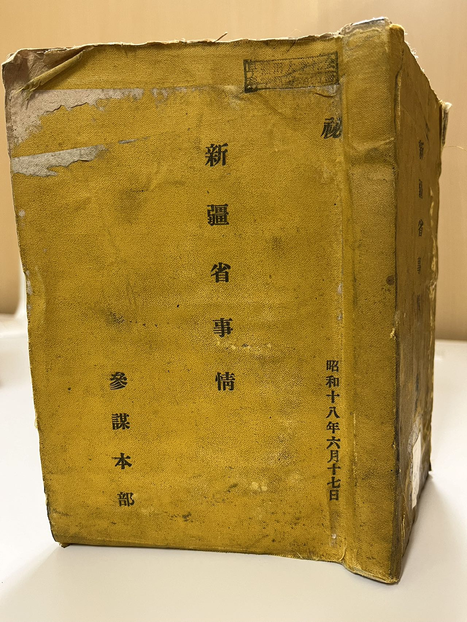
Xinjiang Affairs 新疆省事情 was produced by order of the GSH on 17 June 1943 (figure 1). It bears the mark of “classified” on the cloth-bound cover, and inside, two later stamps of Shō 消 (to destroy/liquidate) under which is a handwritten signature of the GSH.Footnote 75 The preface states that the book was primarily based on “The Compilation of the Military Topography of Xinjiang Province,” produced in 1941 by order of the North China Area Army. However, the GSH deemed the military’s topographic data generally incomplete, and therefore requested “swift collection and examination of supplementary materials” 補修資料ノ迅速ナル收集審查 that drew from six other agencies; three of the reports were newly produced in 1942. Whereas the three older sources were publicly available, such as Keishiro Irie’s (入江啓四郎 1903–1978) 1935 monograph on the “Great Game in Xinjiang,” the three new sources were all military intelligence reports, including the “Comprehensive Investigation of the “Northwestern Route” 西北「ルート」綜合調查 by the North China Area Army, “An Overview of the Support to Chiang Kai-shek in the Northwest” 西北援蔣要覽 by the GSH’ investigation unit, and the “Current Situation in Xinjiang Province” 新疆省現況 by the Kaifeng Reconnaissance Office.Footnote 76 The book is about 9 centimeters thick and contains short but concise chapters on Xinjiang’s topography, transportation and communication infrastructures, aviation routes, the Turkestan-Siberia (Turk-Sib) Railway and the Eurasian Airline, meteorological conditions, public health facilities, urban centers and inhabitants, resources, and ethnicity and religions, in addition to a compendia of seventeen state-of-the-art maps averaging 1.2 square meters in size.
The cloth cover of Xinjiang Affairs (General Staff Headquarters of the Japanese Ministry of Army, 1943, currently deposited at Waseda University Library).
There is no doubt that Xinjiang Affairs was an urgent response to a compelling contingency: Chongqing’s plans to strengthen the northwestern route for bringing the Allied powers’ aid to China. The two-and-half-page “General Statement” 總說, which constitutes chapter one, elucidates this contingency in clear terms. It states that the northwestern route had emerged shortly after the “China Incident” in July 1937, but its importance had only been increasing since the “China Incident” escalated into the Greater East Asian War. The Chongqing government, “emphasizing the northwestern support route, strengthened its infrastructure along this route, not only as a defense against aggression but also as a foundation for resistance and state-building efforts.” The statement acknowledges that the route had been mainly a conduit for the Soviet Union to supply the Chongqing regime with war materiel from the fountain head of the Turk-Sib Railway via the northwest highways. There was a new urgency, though, after the Americans and British made plans to create a new “Chiang aid route” from southwestern Xinjiang through the Pamir mountains. The General Statement further cautions that although constructing a west-east transregional railway would be technologically and financially challenging, Chongqing was eager to begin the undertaking. It also notes that while oases farming currently met the needs of the population, much more land could be developed for agriculture. Similarly, the region’s rich subterranean deposits included oil reserves that could well-supply Chongqing with the material basis for making Xinjiang a base for its state-building. It adds that the region was inhabited by a complex variety of ethnic groups, whose mutual religious exclusions and anti-Han sentiments were marked. It ends by observing that the largest demographic group there was the Turkic Uyghurs 回紇.Footnote 77 The different chapters total just twenty-seven pages, but nearly all highlight structures of military significance. The chapter on communication and transportation tells that the Soviet Union had been upgrading Xinjiang’s transportation and communication networks in the wake of initiating the northwestern route for China aid. The section about the Turk-Sib Railway details the breadth of the railway’s gauge and Almaty’s freight capacity, estimated to be 6,000–7,000 tons per day in 1937. Notably, it asserts that since Germany’s invasion of the Soviet Union, rather than a decrease there had been a dramatic increase in freight traffic through the Almaty terminal, reaching 19,600 tons per day.Footnote 78 We can guess that the freight trains were heading the opposite direction after Operation Barbarossa on 22 June 1941, carrying materials extracted from western Turkestan further west to the front lines. The same chapter says that a southwestern route from India via the Karakoram mountains had been harnessing the region’s existing commerce routes. The GSH surmises that Japan in response would be able to extend its developmental plans to Xinjiang from North China via the Long-Hai Railway (from Lianyungang in northern Jiangsu to Lanzhou in Gansu) and the Jing-Bao Railway (from Beijing to Baotou).
Regarding aviation facilities, the chapter states that the British and the Americans were making plans to begin another Hump from either India or Iran to possible destinations in the Tarim Basin. It reports that flights were already being chartered from Baghdad to Xi’an via stopovers in Tehran, Kabul, and Anxi (Guazhou) in western Gansu. The chapter on major cities lists Urumqi, Suiding (Ili), Yining (Ghuljia), and Kashgar as places of major concern. In Urumqi, it marks out for bombing the northeastern corner, due to the presence of a wireless signal tower there, and the southeastern corner for its airfield. On Suiding, it highlights the northeastern section, where “the ruling Kalmyks” had their residences and granaries, while the arsenal and army barracks were perched on the east and south sides of the city walls. The report nicknames the city of Yining a “Red capital” (赤都) and calls attention to the Soviet consulate and various other military apparatuses there. It again marks Kashgar as the locations of the Soviet and British consulates.Footnote 79
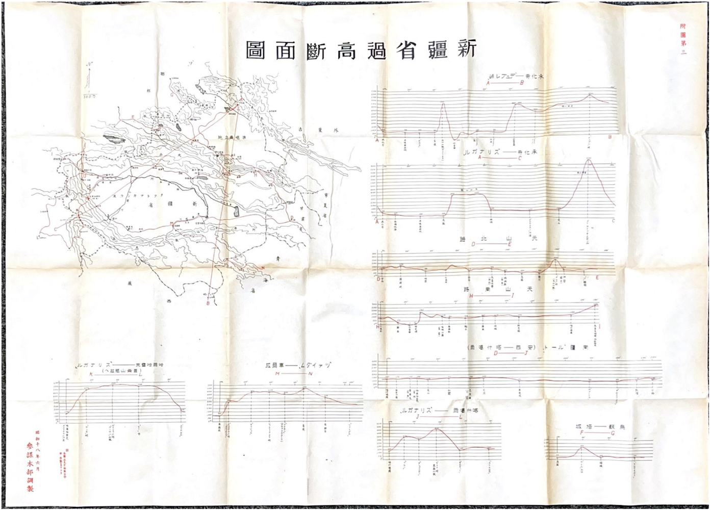
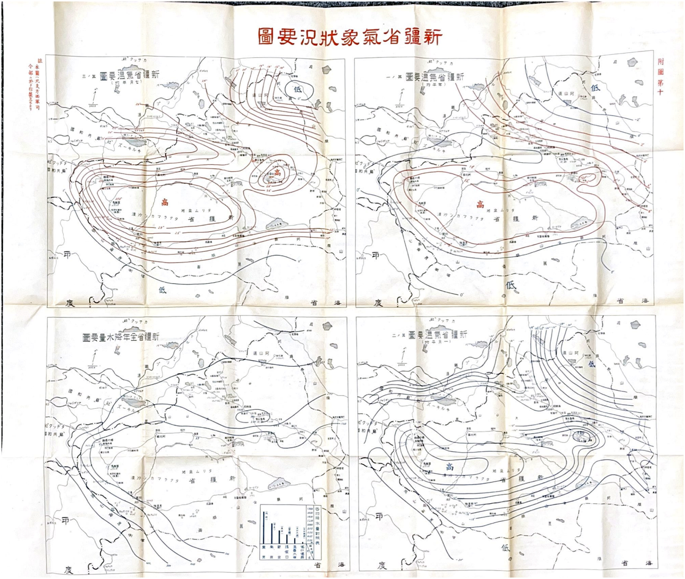
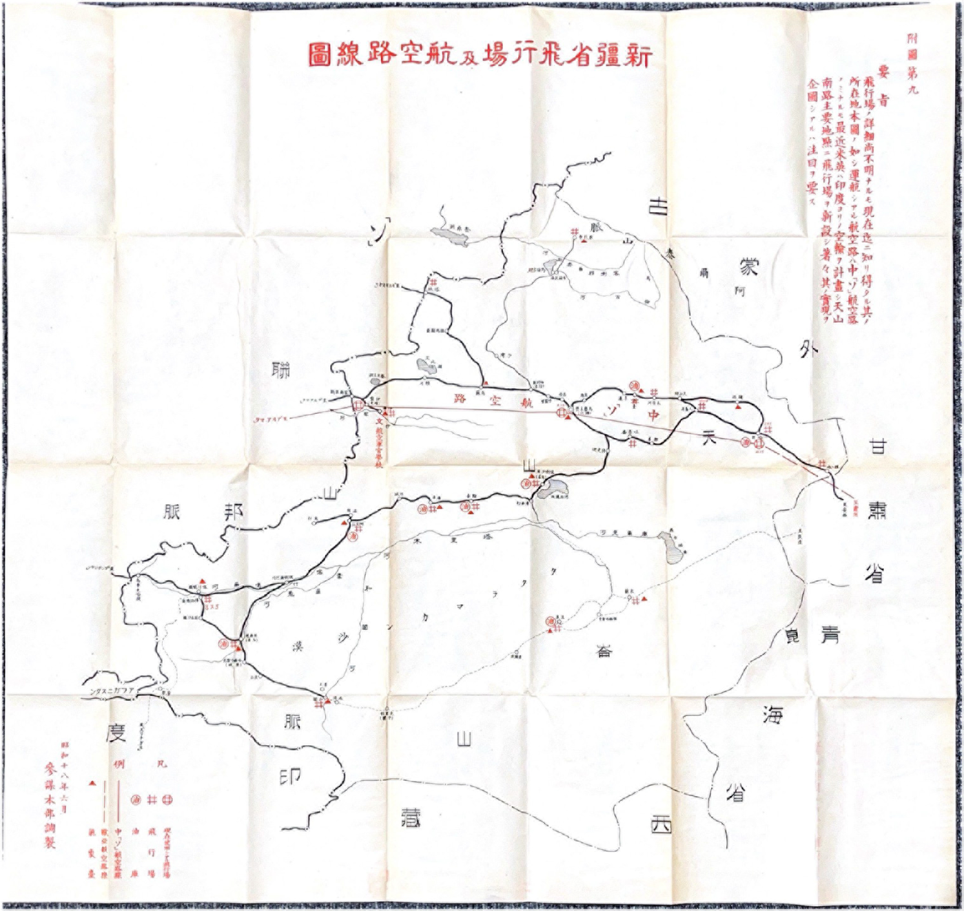
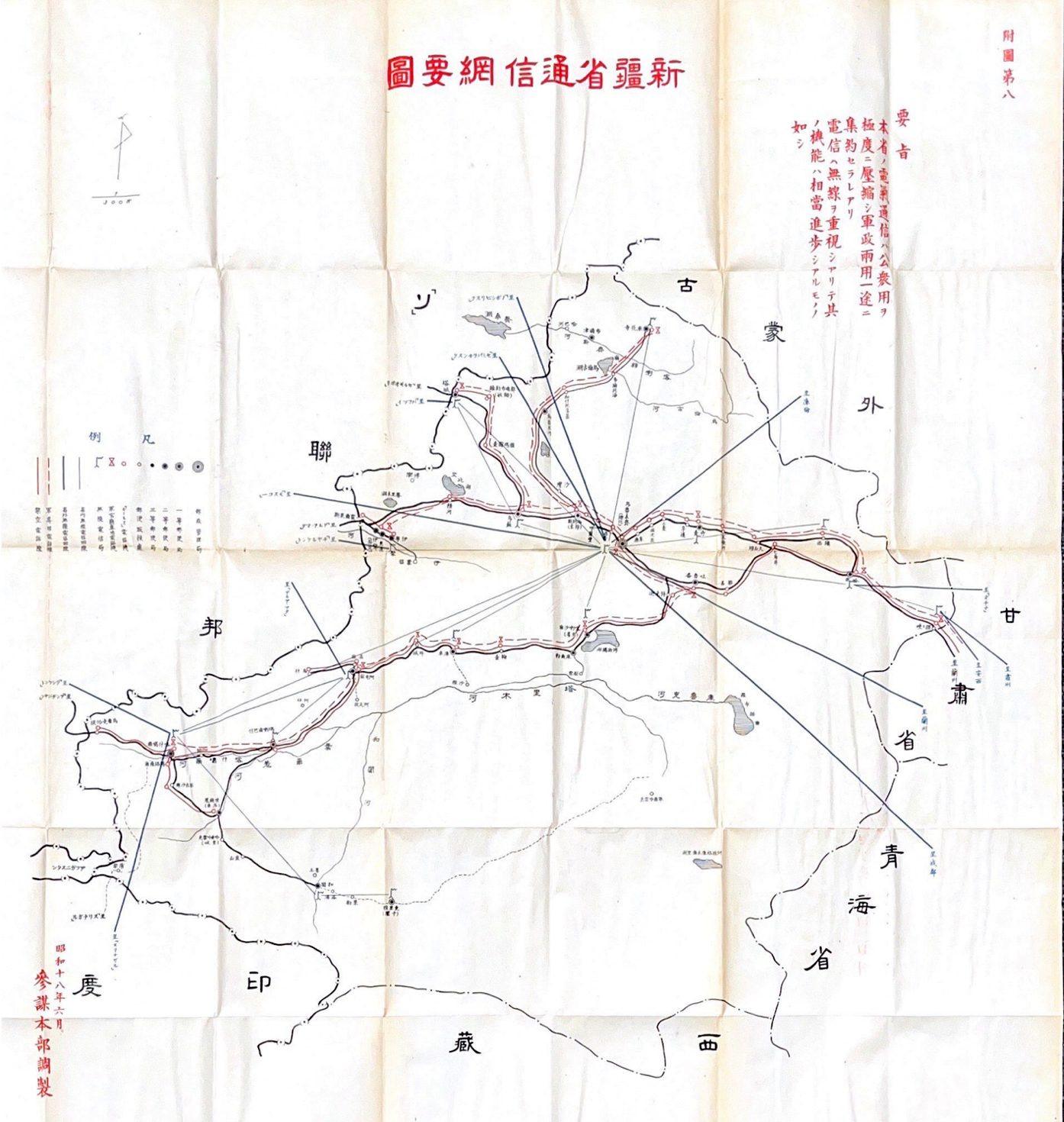
In all likelihood, the GSH was laying down coordinates for a swift military intervention followed by longer-term occupation. The maps on altitudes (figure 2), weather systems (figure 3), airports and aviation routes (figure 4), and marked-out wireless and wired communication networks (figure 5) suggest a plan for aerial bombing. Other maps showing roads for motorized vehicles (attached map 7) and urban centers (attached map 12) could be interpreted as regular nodal points for ground invasions.Footnote 80 Again, all valuable targets for military action are laid out in detail. Yet, this clarity in military aims invites a more significant question: if military action was the centerpiece of Japan’s heretofore unknown grand approach to Xinjiang in the summer of 1943, how could that qualify as part of its “Muslim policy”? In other words, with this charting of eastern Turkestan with such military precision, how did eastern Turks figure in the larger scheme?
Altitudinal extremes of Xinjiang. Attached map 3, Xinjiang Affairs (General Staff Headquarters of the Japanese Ministry of Army, 1943, Waseda University Library).
Meteorological overviews of Xinjiang. Attached map #10, Xinjiang Affairs (General Staff Headquarters of the Japanese Ministry of Army, 1943, Waseda University Library).

Airports and aviation routes of Xinjiang. Attached map 9, Xinjiang Affairs (General Staff Headquarters of the Japanese Ministry of Army, 1943, Waseda University Library).

Wireless and wired communication networks in Xinjiang. Attached map 8, Xinjiang Affairs (General Staff Headquarters of the Japanese Ministry of Army, 1943, Waseda University Library)

Onboarding the Indigenes through Ethnological Encapsulation
A fine-grained analysis of the toponyms and ethnonyms employed in the various maps reveals that the GSH intended to onboard indigeneity, understood as both people and their cultures, as its platform for a possible occupation of Xinjiang. The accommodation of indigeneity, reflected in a conscious privileging of indigenous knowledge production and reproduction over imperial/colonial impositions from outside, is significant because it indicates a cultural sensitivity that aligned with Japan’s political onboarding of indigeneity elsewhere, whether in northeastern Asia or southeastern Asia.Footnote 81 While indigenous toponyms and ethnonyms are loaded cultural repositories ready to attest to a social group’s claim to territorial sovereignty and (dis)connection to historical predecessors, their presence in the highest-level Japanese military maps should be understood with two caveats. First, as described earlier, Japan had been largely unsuccessful in making meaningful connections with the Turkic population during the previous decades. Second, the actual techniques of occupation would have to wait for later treatment, after meeting the immediate goal of militarily cutting Chiang Kai-shek’s supply lines coming from the northwest.
By 1943, diverse sources were available to the GSH to choose from and help it decide on its preferred ethnonyms and toponyms concerning Xinjiang and its inhabitants. The preface of Xinjiang Affairs listed Nakajima Shūhen’s “A Complete Mongol History,” Irie Keishiro’s “Russo-British Rivalry in Xinjiang,” and Kawade Shobō’s 1941 world geography series on China’s frontiers as the three secondary source books that had been consulted.Footnote 82 However, at the time knowledge production on Xinjiang was a small field onto itself. For example, S. V. Nedachin’s Modern Xinjiang, originally published in Dairen in 1935, was translated into Japanese as Gendai Shinkyō the same year by Nakahira Ryou. Both authors were at the time employed by the economic investigation unit of the Southern Manchurian Railway Company (hereafter Mantetsu).Footnote 83 The Russian mining engineer Pavel Stepanovich Nazaroff’s 1935 travelogue Moved On! From Kashgar to Kashmir became available in Japanese translation in June 1943.Footnote 84 Tachibana also published his travelogue Shinkyō Tankenki (A chronicle of Xinjiang adventures) in 1912.Footnote 85 Predictably, there was no consensus across these works regarding the proper ethnonym for Xinjiang’s majority inhabitants. Tachibana does not distinguish between the nomadic Kirgiz and the sedentary Uyghurs in and around Kashgar and lumps all Turkic groups together as “the Turk people” 土耳古人.Footnote 86 For him, possibly due to his Buddhist interest and his teacher’s knowledge of world geography, only the Mongols and Chinese in Xinjiang deserve their own respective categories. Nedachin, thanks to his Russian cultural roots, adopts the term “Sart” (transliterated in Japanese as サルトSaruto) in his Modern Xinjiang to refer to the sedentary Muslim majority; that is, today’s Uyghurs in the Tarim Basin, while he categorizes the sedentary Turkic people in Ili as “Taranchi.”Footnote 87 The Chinese-speaking Dungans and the nomadic Kirgiz are identified as separate groups. The translation of Nazaroff’s From Kashgar to Kashmir again offers the sobriquet of Sart to refer to Turkic Muslims in Kashgar.Footnote 88 The Hui/Dungan Muslim general Ma Fuxing 馬福興 is simply referred to as Chinese. In sum, the published sources left the authorities with more confusion than clarity.
Tokyo’s experts on Muslim affairs were also divided regarding ethnological concepts. Owada Masato, who went by his Muslim name Zekil and was a Muslim convert who served the Greater Japan Muslim League in some advisory capacity, dismissed all ethnic identities. For him, Muslims from Henan, Qinghai, Shandong, and Xinjiang were all Muslims, pure and simple.Footnote 89 Another booklet, published in the same manner and around the same time as an internal reference for the DNKK, did not discuss Muslims in North China and Central China. It focused on the greater northwest and asserted that the territory comprised of Shaanxi, Gansu, Ningxia, and Qinghai were historically Turkic land (元來土耳古族の固有國土).Footnote 90 The original Turkic inhabitants who remained on these lands, due to Chinese invasion and cultural entrenchment, became Sinicized Turks, known later as either “Han-Hui” or “Dungan.”Footnote 91 This position, taken as the fruit of the DNKK’s official investigation, uses the term “Huihe” 回紇 to refer to the Turkic majority in Xinjiang, and it insists that the Huihe people are the “Shujinkō” 主人公, meaning the main protagonist and rightful owners of the land.Footnote 92
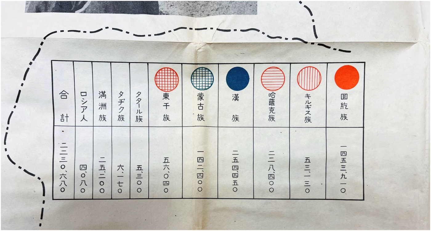
There is good reason to believe that the DNKK’s collective position directly informed that of the GSH. The earlier internal reference booklet came out in print in January 1943, and Xinjiang Affairs appeared five months later. Out of many choices, including Sheng Shicai’s ethnic classification taxonomy that adopted the neologism of “Weiwu’er” 維吾爾 in his 1934 provincial legislature, the GSH adopts the archaic Huihe 回紇 for the sedentary Turkic population in Xinjiang. At first glance, this seems an odd choice given that a katakana transliteration of the most popular term adopted by indigenous intellectuals would be more plausible.Footnote 93 Disagreement with Sheng Shicai’s taxonomy goes further still. Rather than institutionalizing fourteen different groups—the Han Chinese, Uyghurs, Mongols, Kazakhs, Dungan, Sibe, Solon, Manchu, Kyrgyz, White Russian, Taranchi, Tajiks, and Uzbeks—Xinjiang Affairs endorses only ten, possibly collapsing Sibe into Manchu, Solon into Mongol, and Taranchi and Uzbeks into Uyghurs (figure 6).Footnote 94 The adoption of the ancient ethnonym Huihe 回紇 is likely a “symbolic construction of community.”Footnote 95 It was not just any community construction, but one that confirms what Anthony D. Smith calls “a template for ethnic elites in search of a ‘golden age’ of unity and strength.”Footnote 96 The sinological term Huihe is a signifier of ethnic sovereignty par excellence. It not only recalls the Uyghur Khaganate (744–840) in the pre-Chinggis Mongol Plateau, but more importantly, the Tianshan Uyghur Kingdom around the Turfan Depression and the Ganzhou Uyghur Kingdom that territorially overlap with contemporary Northern Xinjiang and western Gansu.Footnote 97
Demographics and ethnic breakdowns of Xinjiang’s residents. A magnified part of attached map 16. Xinjiang Affairs (General Staff Headquarters of the Japanese Ministry of Army, 1943, Waseda University Library).

The choice of toponyms reflects a broader respect for indigeneity in that Xinjiang Affairs relegates nearly all Qing-era Sinitic place names as secondary, enclosed in brackets, while privileging non-Sinitic toponyms possessing a longer history. For example, it adopts Urumqi instead of Dihua 迪化 for the northern metropolis. Although the etymology of Urumqi is unclear, with some scholars arguing that it was named after a Mongol warrior, and others that it was a variation of irumcina from Sanskrit, the term was already in wide use during the Dzungar Empire.Footnote 98 By contrast, Dihua was a more recent invention, coined by the Qianlong emperor to mean “to enlighten and civilize” following the Manchu conquest of the city in 1755.Footnote 99 Xinjiang Affairs also chooses Karashar over the Sinitic term Yanqi 焉耆, Manas over Laisui 來綏, Ili over Dingsui 定綏, Yarkand over Shache 莎車, Kargilik over Yecheng 葉城, and Keriya over Yutian 於闐. The only exceptions were Altay and Kumul. For Altay, Xinjiang Affairs follows the Chinese convention of Chenghuasi 承化寺, another Qing-era neologism to commemorate its reconquest by a Tibetan lama-cum-tulka from Kokonor (Qinghai) in the aftermath of the Great Northwest Muslim Rebellions (1862–1874). For Kumul, the GSH adopts Hami 哈密, presumably due to the predominance of the Sinitic term in recent history.Footnote 100 Shunning the prevailing Chinese taxonomy for Xinjiang’s peoples and places in most cases, the GSH’s onboarding of indigeneity in Xinjiang issues largely from its own multilingual and multi-perspectival research conducted by Tokyo’s Muslim Policy circles, particularly those rallied behind the DNKK. Contrary to Lattimore’s theory that Japan was conjuring up a “Muslim state” in Xinjiang, the GSH’s Xinjiang Affairs treats Xinjiang’s indigeneity with considerable nuance and realism. It acknowledges that the region’s population is divided into ten racial groups. Although the Huihe stands out as a clear majority, Xinjiang Affairs pays meticulous attention to the gathering of accurate demographic data in its ethnic as well as regional breakdowns. Utilizing nine different sources, including a census from the era of Yang Zengxin, a Chinese strongman of the previous era, postal surveys, Mantetsu’s investigation reports, and the North China Area Army’s own investigation reports, it offers demographic data that was precise down to the double digits. For example, its estimate for Xinjiang’s total population stands at 2,230,680, with Uyghurs numbering 1,453,910, or 65 percent, while the Han Chinese number 254,450, or 11 percent. In the regional breakdown, the Chinese were in the majority in Urumqi, with 39,000 or 89 percent. By contrast, with the exception of Aksu, where Uyghurs make up just over 50 percent, Uyghurs are predominant majorities in Kashgar, Yarkand, Hotan, Keriya, Kucha, Turpan, Shanshan, and Hami, while 228,400 Kazakhs predominate in both Altay (Chenghuasi) and Tarbagatai.Footnote 101 Clearly, the GSH was interested in onboarding the Muslims, Huihe as well as other groups, as their main indigenous allies, but it was equally interested in the demographic realities of specific districts.
As Prasenjit Duara laid out in his study of Japan’s 1930s ethnological denotation of the Oroqen people (estimated to number a mere three thousand people) as an “authentic” national group of Manchukuo, Japanese attentiveness to ethnonational specificity and indigenous claims to sovereignty was distinctive, if not unique, among early twentieth-century imperial powers.Footnote 102 To be sure, the Dutch had experimented with a so-called “Ethical Policy” in the East Indies in the 1920s, and the British began seriously entertaining self-government for both Hindus and Muslims after World War I.Footnote 103 Yet both empires ultimately rejected indigenous sovereignty, and treated demands for power-sharing largely as matters of political expediency. In contrast, Japan departed from the detached gaze of colonial rule by actively investing in the rights of indigenous peoples to stake claims to sovereignty, as junior partners in a shared imperial enterprise. This investment may have been partly a reaction to the Soviet Union’s half-hearted accommodation of autonomist activism among other northeast Asian groups, particularly Koreans and Buryat Mongols.Footnote 104 Nonetheless, it positioned Japan as offering a competitive model of political onboarding for multiple subordinate communities in Manchuria and North China. Although still entirely aspirational at the time, ethnopolitical demography was more advanced than Chiang Kai-shek’s “Chinese Nation as One” rhetoric, and it would later become a central mechanism of national mobilization in the postwar global proliferation of ethnonational states.Footnote 105
Conclusion
When Japanese explorers and researchers compiled their topographical data on Xinjiang in the early 1940s, they often found themselves grappling with a maze of parallel place names and ethnonyms for the region’s finite number of indigenous inhabitants and their hometowns. As a region in the shadows of empires that had long been competitors, often since the Industrial Revolution, Xinjiang struck the late-coming Japanese Empire as a territory displaying a palimpsest of temporalities and historical consciousnesses. As I have shown here, the production of knowledge on such a territory was less about finding new empirical data and more a matter of sifting through an already plentiful store of existing data, with a clear objective and an operating principle of selectivity. For Japan, that operating principle was to detach Xinjiang from Sinitic claims of ownership, and to forestall the Allied powers from aiding Chinese state-building in the region by effacing the Turkic and Islamicate features of its indigenous majority. While the GSH’s immediate military objectives foregrounded this principle, in the background was the sifting through of existing data to produce Japanese knowledge of Xinjiang, and this cannot be understood through solely the narrow lens of Sino-Japanese enmity.
The article has shown that Japan’s investigative expeditions to Xinjiang before the 1940s were a part of the often-collaborative but sometimes competitive scientific imperialism that drew world explorers from as far afield as Sweden, Britain, Germany, Russia, and Japan itself. Japan’s geostrategic interest in Xinjiang did not, for the most part, stem from a desire to conquer or dominate Xinjiang per se. Rather, Xinjiang was closely watched with an interest in coordinating imperial expansion and consolidation elsewhere, particularly in Manchuria. This crucial insight tells us that the Russo-Japanese War in 1904–1905 did not settle the geopolitical rivalry between the two powers. One may argue that Russo-Japanese rivalry was the defining fault line in the geopolitical configuration of northeast Asia throughout the first half of the twentieth century. Japan did envision an “anti-Communist ring” that included Afghanistan and Xinjiang in the early 1930s, two decades before the “liberal world” undertook a similar project in the Cold War. This was again the case when, between 1937 and 1941, Soviet Kazakhstan became the chief supplier for Chiang Kai-shek’s regime through the Xinjiang-borne northwestern route.
This article has also shown that the Russo-Japanese rivalry became a truly world historical event in 1942, when the Allied powers sought to revive the northwestern China aid Route after the fall of Burma cut off their supply chains to the China Theater. The implications of that unprecedented solidarity shared by the Soviet Union, the United States, Great Britain, and China against one common foe—Japan—are manifold. It pushed Japan to swiftly draw up plans for an adventurous military intervention in the heart of central Eurasia. The alliance also centered the Muslim northwest, including both Xinjiang and its neighboring Gansu and Qinghai provinces, in the enterprise of Chinese state-building like never before, and brought into the region the construction of airfields, highways, wireless networks, and “central government armies.” It also spelled doom for the Hui Muslim militarist authority that had kept Chinese control at arm’s length for nearly half a century.
This westward shift of China’s national political gravity is comparable in significance to the massive wave of both Chinese and international settlement in Manchuria starting in the nineteenth century—a transformation that by the mid-twentieth century was propelling the region’s rapid industrialization and urbanization. That transformation, especially its formative beginnings, in turn fueled the long-running Russo-Japanese rivalry in northeast Asia and reinforced China’s drive to secure lasting recognition of Manchuria as an integral part of its national territory. By placing Xinjiang within Japan’s “Muslim Policy” knowledge-production complex, this article has underscored the region’s emergence as a world-historical space in the modern era, and foregrounded Islam in China, both its Turkic-speaking and Chinese-speaking adherents, as an essential part of mid-twentieth-century global history.
Acknowledgments
I would like to express my sincere gratitude to Professor Tomoyasu Iiyama and librarian Osamu Shimada at Waseda University for generously granting me access to DNKK-related materials essential to this research. I am also grateful to Professor Nargis Kassenova and other colleagues who offered valuable feedback during the International Conference on the Historical Geography of Central Asia, held in Almaty during the summer of 2024. Financial support from the Asian Studies Center at the University of Pittsburgh was instrumental in enabling this research. I also wish to thank the anonymous reviewers for CSSH, whose insightful comments and critiques greatly helped refine the arguments presented in this article. Finally, I owe much gratitude to David Akin, the managing editor of CSSH, for his meticulous wordsmithship, which helped sharpen my expression substantially.


 Open access