

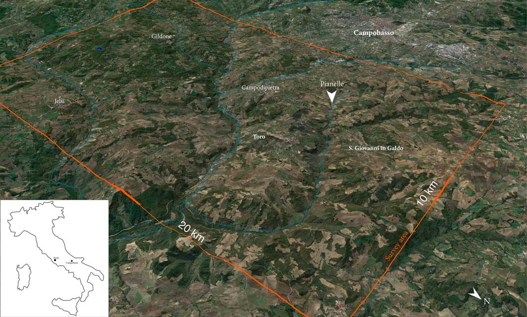
The Tappino Area Archaeological Project (TAAP) studies ancient society in the area surrounding the Tappino River Valley in southern Italy (modern Molise) (Figure 1). In this mountainous landscape, human settlement developed along different trajectories than those on the urbanised coastal plains. The inland polities—usually referred to collectively as Samnites—could, however, field a formidably large army to oppose the expanding Roman Empire during the fourth to first centuries BC (Livy, History of Rome 4.8–10; Foster Reference Foster1922; cf. Oakley Reference Oakley1997). The nature of these resilient non-urban polities sparks curiosity, as societal success and high population densities in the ancient world are usually associated with urbanism (see Dench Reference Dench1995; Morgan Reference Morgan2003). Scepticism about the apparent level of socio-political complexity present in this non-urbanised area has even led to questioning the accuracy of Roman sources concerning Samnium’s military power. The alternative option—that a non-urban societal model such as Samnium’s could be successful in its own right—needs further testing, and archaeology is well positioned to attempt this. The previous Sacred Landscape Project (SLP 2004–2010) investigated the potential role of sanctuaries in such a non-urban settlement configuration. By pedestrian field surveys, the SLP contextualised the sanctuaries of Colle Rimontato, San Giovanni in Galdo and Cupa, Gildone, in their local and regional settlement organisation (cf. Di Niro & Petrone Reference Di Niro and Petrone1993). On the basis of these surveys, several theories about the function and positioning of rural sanctuaries could be tested (cf. Stek Reference Stek2009: Chapter 4 for these models). The SLP concluded that the cult places were not isolated special-purpose sites, but rather, focal points of rural communities that ‘clustered’ around the sanctuary, and in farms and villages (Pelgrom & Stek Reference Pelgrom and Stek2010).
The research area in the Upper Tappino Valley, approximately 20×10km (image by A. Hamel).
Many questions remain, however. To what extent was high site density—and thus presumably a dense ancient population—limited to areas with cultic sites? Did sanctuaries ‘attract’ settlement, or was the landscape overall densely settled? What are the effects of, amongst others, erosion, alluviation and present land-use on the detection of ancient sites by field archaeologists? What was the role of other large sites, such as villages and hilltop sites? What could all this mean for current demographic reconstructions and historical scenarios? As archaeological sites in mountainous areas are notoriously difficult to access, addressing such questions requires highly intensive field approaches and the painstaking study of finds, with usually few chronological anchors.
The TAAP applies such an intensive, holistic archaeological approach to contextualise, both spatially and chronologically, sanctuaries, hillforts and other sites in the area with greater precision. First, the plausibility of the proposed, ‘clustered’ model of settlements associated with sanctuary sites is tested. Second, the project aims to improve our understanding of the character of newly discovered surface sites, by intensifying intra-site surface analysis and excavation. Third, the project develops methods and field tests to compare different survey methods, and to enable the integration of different (legacy) datasets in Molise, especially the Biferno, San Vincenzo and Aesernia projects (Barker Reference Barker1995; Bowes et al. Reference Bowes, Francis and Hodges2006; Stek et al. Reference Stek, Modrall, Kalkers, Van Otterloo and Sevink2015). Altogether, the project aims to compare and combine the different elements and connections that constituted local ancient societies, and seeks to strengthen the dataset sufficiently to engage in comparative studies with other Italian and Mediterranean areas.
Methods and results
Our methods include field survey, excavation and remote-sensing techniques. We tested the ‘cluster hypothesis’ by surveying a statistically significant portion of different types of landscape and geology, including areas that are normally omitted from analysis for reasons of visibility, accessibility and expected absence of archaeological remains. Blocks of 1×1km were surveyed as completely as possible by ‘off-site’, full-collection survey, in which all accessible fields were surveyed with teams of 5–6 archaeologists walking 10m apart and collecting all finds in a 2m-wide strip. Field surveys often focus on agricultural areas for reasons of visibility, accessibility and efficiency (Alcock & Cherry Reference Alcock and Cherry2004; Attema et al. Reference Attema, Burgers and Van Leusen2011). To gain a better understanding of those portions of the landscape that are thus usually skipped, such as hilltops or other areas with thick vegetation, we used LiDAR data and applied point sampling after superficial topsoil cleaning. Thus, we detected, for example, various hidden sites at the Montagna di Gildone hillfort and a large Classical/Roman site at Colle S. Martino, Jelsi (Figure 2).
LiDAR rendering of the hill-fort of Montagna di Gildone, with point samples in red (image by J. García Sánchez).

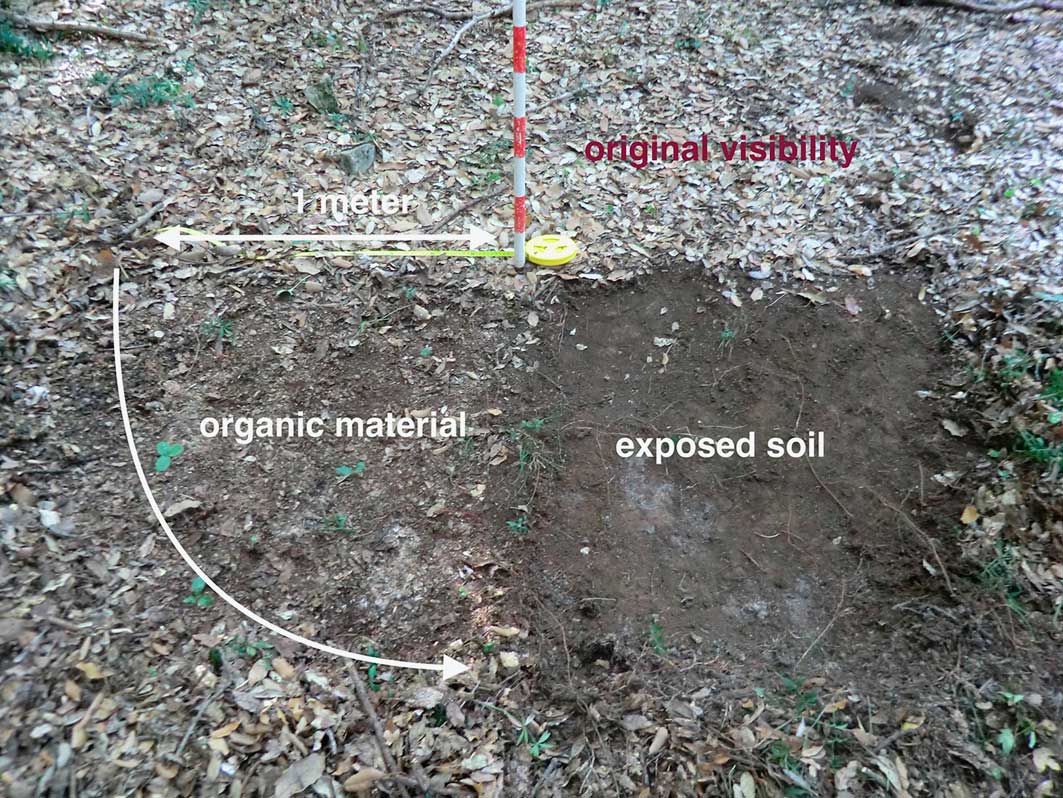
Point sampling is effective for large sites due to its high spatial control (Figure 3). It forms a (cost-) effective approach, particularly when combined with imagery from drones and geophysical data (Figure 4). Two rural sites that we excavated—S. Giovanni in Galdo and at Gildone—yielded not only new information about the surviving structures, but also about their chronology (radiocarbon) and their correlation with finds from other sites revealed by the landscape surveys around the two excavated sites (Figure 5).
Point sampling as a method to sample large rural sites with variable ground visibility caused, for example, by thick vegetation or organic material in non-agricultural, forested areas (image by J. García Sánchez).
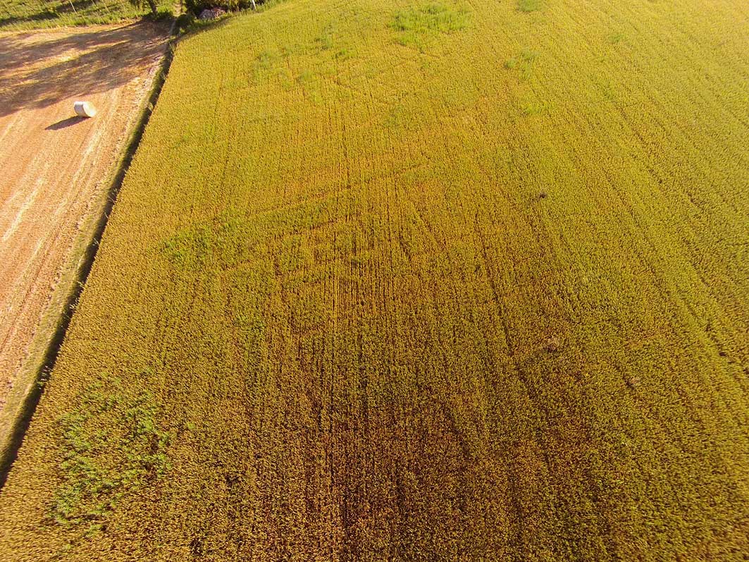
Drone picture of the Le Pianelle site (image by T.D. Stek).
Excavations at the site of Colle Rimontato, San Giovanni in Galdo (image by R. Kalkers).

This study is supplemented by expert revision of the local ceramic typologies and chronologies using TAAP as well as legacy data, applying various techniques (e.g. XRF). Together, the project reveals a rich archaeological landscape, particularly dense with Hellenistic and early Roman settlements clustered on hill plateaus (Figure 6). We are working towards a greater understanding of non-urban settlement organisation in the tumultuous Classical/Hellenistic and Roman periods, with growing precision and less destructive detection and documentation methods.
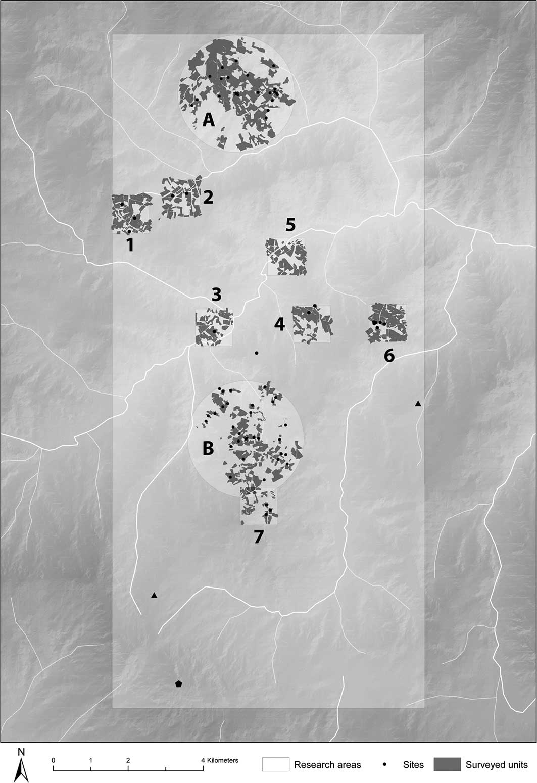
Map of the survey area: A) sanctuary of Colle Rimontato, San Giovanni in Galdo; B) sanctuary of Cupa, Gildone; 1–7) off-site sample areas; 7 corresponds with Montagna di Gildone (image by R. Kalkers).
Acknowledgements
I would like to thank the Soprintendenza Archeologia del Molise and the municipalities of Jelsi, Gildone and San Giovanni in Galdo for our collaborations, leading to the Centro Didattico Internazionale di Studi Archeologici di Jelsi (CeDISA). I sincerely thank the numerous participants.


