

Introduction
Radar backscatter from sea ice is determined by volume and surface scattering of the ice and overlying snow. These depend on ice and snow properties such as salinity, porosity, grain-size, wetness and surface roughness. This allows the detection of multi-year ice in the Arctic, since it has higher backscatter coefficients than first-year ice due to its desalinated, porous surface ice (Reference Onstott and CarseyOnstott, 1992). Since the backscatter signature changes with time (e.g. due to summer warming), the seasonal cycle of radar signatures can be utilized to monitor melt onset and freeze-up in the Arctic (Reference Barber, Thomas, Papakyriakou, Tsatsoulis and KwokBarber and others, 1998; Reference Winebrenner, Long, Holt, Tsatsoulis and KwokWinebrenner and others, 1998). The former is detectable by a sudden decrease in multi-year ice backscatter once air temperatures approach or exceed 0°C and the ice surface becomes saturated with meltwater. Freeze-up is indicated by a slow return of backscatter coefficients to winter values.
In Antarctica, different ice types have also been identified based on their characteristic backscatter coefficients (Reference Drinkwater and HaasDrinkwater and Haas, 1994; Reference Drinkwater and JeffriesDrinkwater, 1998; Reference Morris, Jeffries, Li and JeffriesMorris and others, 1998). Reference Drinkwater and LiuDrinkwater and Liu (2000) used a drop of backscatter coefficients to map melt onset over seasonal pack ice around Antarctica. In contrast to these observations, few studies have shown that backscatter from perennial ice in the Antarctic behaves opposite to the seasonal ice and to ice in the Arctic, since it is higher in summer than in winter (Reference Drinkwater and LytleDrinkwater and Lytle, 1997; Reference Drinkwater and JeffriesDrinkwater, 1998; Reference Morris, Jeffries, Li and JeffriesMorris and others, 1998). A conclusive explanation for this has yet to be put forward.
Time series of European Remote-sensing Satellite (ERS) radar scatterometer data of perennial Antarctic sea ice are continuously available as weekly mean backscatter values around Antarctica. Consequently, the seasonal evolution of backscatter signatures can be described in detail. Based on ice-core and snow data from perennial ice in summer (Haas and others, in press), the seasonal cycle of backscatter signatures, and in particular the increased summer values, is subsequently addressed.
Satellite Data Analysis
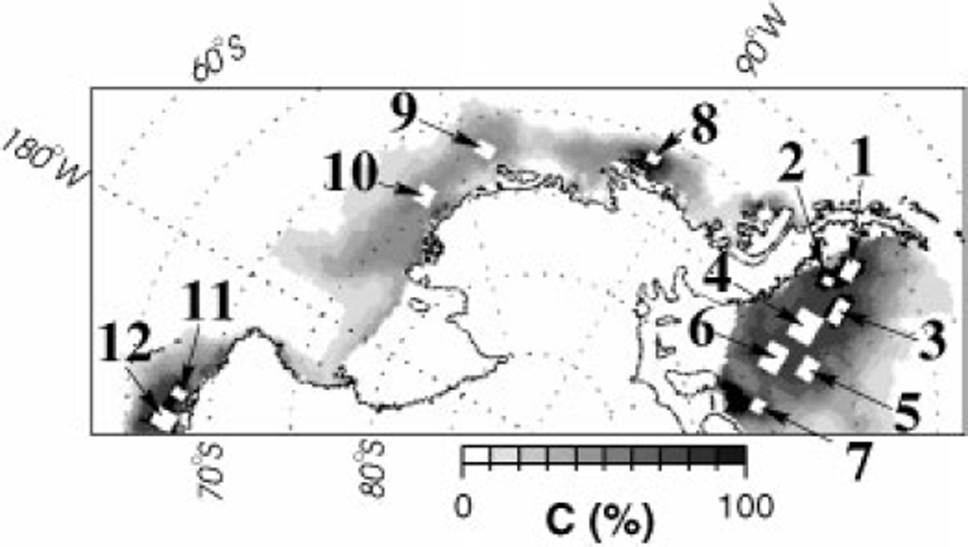
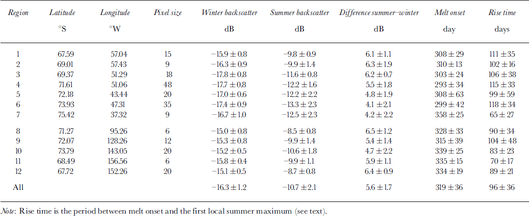
ERS-1/2 scatterometer (ESCAT) data were obtained from the polar sea-ice grids distributed on CD-ROM by the Centre ERS dArchivage et de Traitment (CERSAT) of the Institut Francais pour l’Exploitation de la Mer (IFREMER), France. The data are weekly averages of VV-polarized, C-band (frequency 5.3 GHz, wavelength 5.7 cm) backscatter along 500 km wide swaths, which are projected onto a polar stereographic grid with a pixel size of approximately 25 ×25 km2. Here, we used the backscatter coefficients normalized to an incidence angle of 40° ![]() after Reference GohinGohin, 1995). Time series were computed for 12 perennial-ice regions, from June 1991 tojune 1999. Regions 1−7 are distributed from north to south in the western Weddell Sea, while regions 8−12 cover the coastal area of the Bellingshausen, Amundsen and Ross Seas (Fig. 1, Table 1).
after Reference GohinGohin, 1995). Time series were computed for 12 perennial-ice regions, from June 1991 tojune 1999. Regions 1−7 are distributed from north to south in the western Weddell Sea, while regions 8−12 cover the coastal area of the Bellingshausen, Amundsen and Ross Seas (Fig. 1, Table 1).
Map of the west antarctic, showing the location of 12 test regions where backscatter time series were computed (fig 2). grey shading indicates the mean february ice concentration ( c), 1992−99, derived from satellite passive-microwave (ssm/i) data.
Main characteristics of the seasonal backscatter cycle in the 12 regions of figures land 2 (mean ±1 std dev.)
At low ice concentrations ( <90%), pack-ice backscatter is biased by wind roughening of open water between ice floes (Reference Drinkwater and LiuDrinkwater and Liu, 2000). To minimize this bias, only areas with high average February ice concentrations were taken into account (Fig. 1). Ice-concentration time series of the 12 regions were derived from Defense Meteorological Satellite Program (DMSP) Special Sensor Microwave/Imager (SSM/I) passive-microwave data distributed by the U. S. National Snow and Ice Data Center (NSIDC) on CD-ROM (NSIDC, 1997). They are daily ice concentrations projected onto the same grid as the ESCAT data. Here, weekly mean concentrations were calculated corresponding to the weekly ESCATdata.
Because the analyses have been carried out on a fixed spatial grid, the derived variations may be partly due to seasonal changes and partly due to advection of ice with different surface properties. To overcome this uncertainty, backscatter values were additionally computed along selected ice-drift trajectories, i.e. in a Lagrangian reference system, for a full year. Since no appropriate drift data were available from buoys, the drift trajectories were taken from numerical sea-ice model calculations of Reference Harder and FischerHarder and Fischer (1999). The model was optimized for good agreement between observed and calculated ice drift.
Results
Figure 2 shows time series of backscatter and ice concentration for the 12 regions indicated in Figure 1, and the average of all regions. All regions show a strong seasonal cycle with increased summer backscatter. The sharp increase in November/December and the slow winter decrease are most obvious in the averaged time series. Spring rise and summer maximum are occasionally interrupted by sudden strong backscatter drops, usually only lasting 1 week (Fig. 2). The distinct seasonal cycle is obviously independent of ice concentration, since it occurs even though ice concentrations remain close to 100% in many cases (Fig. 2). In other cases, the summer backscatter rise is not synchronous with ice-concentration decreases.
Time series of weekly mean backscatter coefficients at 40° incidence angle and ice concentration in the perennial-ice regions shown in figure 1, and for all regions averaged (bottom right). arrows point to some sudden backscatter drops typical for summer signatures.
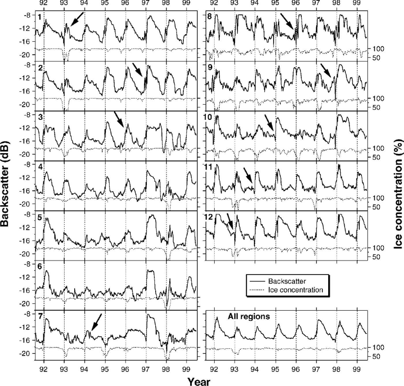
Winter minima and summer maxima have been chosen from smoothed (three-point running average) time series as the local minima preceding and local maxima succeeding the spring rise, respectively, although this procedure is not always unequivocal. Table 1 summarizes the main characteristics thus derived. On average, backscatter increases from a winter minimum of −16.3 dB to a summer maximum of −10.7 dB over a 96 day period, commencing on day 319 (15 November). The differences between summer and winter backscatter are most pronounced in the northwestern Weddell Sea (regions 1−3) and in the Bellingshausen (region 8) and Ross Seas (regions 11,12) Fig. 2; Table 1).
The backscatter evolution along three selected drift trajectories for the years 1993−95, commencing on 1 October at 74° S, 50° W, is portrayed in Figure 3. The drift was more or less northward and parallel to the Antarctic Peninsula. In all three cases, backscatter increases from about −17 dB in November to about −13 to −10 dB in February. There is a sudden weak backscatter drop at the end of January 1995. Backscatter decreases during autumn and winter. However, in contrast to the cycles at fixed positions in Figure 2, backscatter of the Lagrangian measurements does not return to the spring values at the beginning of the drift. This is in agreement with the observed backscatter increase of the time series from regions 7 (south) to 1 (north) in Figure 2.
Backscatter evolution and ice concentration along three drift trajectories derived from model results of Reference Harder and Fischerharder and fischer (1999), starting at 74° s, 50° won 1 october 1993, 1994 and 1995, respectively.

Discussion
From ice-core and snow data of perennial sea ice in the Amundsen, Bellingshausen and Weddell Seas in February, Haas and others (in press) propose a suite of processes taking place at the snow-ice interface during summer. These are governed by strong snow metamorphism and the extensive formation of superimposed ice due to internal snowmelt and subsequent refreezing of downward-percolating meltwater at the colder snow-ice interface. These processes commence once the energy budget at the snow surface becomes positive in spring. Superimposed ice contains air bubbles several millimetres in diameter, and its salinity is typically almost zero. The transition to the overlying coarse-grained and salt-free summer snow is very rough on the centimetre scale. These properties significantly enlarge the microwave volume- and surface-scattering intensities of the ice surface. Similar effects were reported by Reference Holt and DigbyHolt and Digby (1985) and Reference Onstott and CarseyOnstott (1992). Therefore, we assume that the strong spring backscatter rise seen in Figures 2 and 3 coincides with the formation of superimposed ice.
A widespread phenomenon in the Antarctic is sea-water flooding of the basal snow, when the ice surface is suppressed below the water level due to heavy snow loading (Reference Eicken, Lange, Hubberten and WadhamsEicken and others, 1994; Reference Jeffries, Worby, Morris and WeeksJeffries and others, 1997). However, Haas and others (in press) found a clear indication that superimposed ice formed also above the saline and cold flooded snow layer (often referred to as "slush layer"), when the fresh meltwater percolated onto the cold and saline slush. The process is similar to the formation of an ice layer at the meltwater/sea-water interface of under-ice melt ponds in the Arctic (Reference EickenEicken, 1994) by double diffusion. Thus, while sea-water flooding alone would cause a decrease in backscatter, superimposed-ice formation above the slush layer results in the opposite effect. This was not recognized by Reference Drinkwater and LytleDrinkwater and Lytle (1997), although Reference Lytle and AckleyLytle and Ackley (1996) showed that superimposed ice also formed above the flooded snow during their study period in the northwestern Weddell Sea.
Snowmelt on perennial Antarctic ice seems to be too weak to cause significant snow wetting, which would result in the attenuation of radar waves, as observed in the Arctic (Reference Barber, Thomas, Papakyriakou, Tsatsoulis and KwokBarber and others, 1998; Reference Winebrenner, Long, Holt, Tsatsoulis and KwokWinebrenner and others, 1998). In fact, measurements by Haas and others (in press) indicate that summer snow wetness is mostly <4%. However, the sudden backscatter drops in spring and summer indicate that episodic phases of enhanced snowmelt and meltwater saturation nevertheless occur. These result from the passage of large-scale synoptic systems causing advection of warm air masses (Reference Morris, Jeffries, Li and JeffriesMorris and others, 1998). Soon afterwards, wetness decreases again, leaving behind larger snow grains and increased backscatter. The temporary backscatter drops in spring might also indicate sea-water flooding events before superimposed-ice formation commences (see above).
Superimposed-ice formation leads to an upward-growing ice surface with a resulting positive freeboard. This process competes with a steady submergence of floes due to bottom and internal melting, and surface accumulation of precipitation (Haas and others, in press). Once superimposed-ice formation ceases because of surface cooling in early autumn, submergence will become the dominant process. Thus, the freeboard of the ice surface will slowly become negative, and the well-known flood-freeze cycles during the cold season commence. This surface flooding with saline water will gradually attenuate radar waves at the incidence angle of ESCAT, and will cause the slow decline of backscatter during autumn, winter and early spring. In those periods, the formation of new ice in leads between diverging perennial floes will also contribute to a decrease of backscatter coefficients.
As superimposed-ice formation sets in once the surface energy balance reverses from negative to positive, it should be possible to monitor these reversals and their southward progression using scatterometer time series. It was shown above that, on average, backscatter begins to rise on day 319. However, in Table 1, no obvious temporal progression is visible from the northern towards the southern Weddell Sea. Only the magnitude of the seasonal cycle decreases towards the south, indicating less extensive snowmelt and superimposed-ice formation. The detection of an accurate rise date is hampered by averaging over 1 week intervals, as well as by the inherent variability of the signal due to other effects. For example, roughening of the ice surface due to ice deformation also causes higher backscatter (Reference Drinkwater and JeffriesDrinkwater, 1998; Reference Haas, Liu and MartinHaas and others, 1999), and can therefore potentially hide any climatic effects on backscatter. In fact, the anomalous cycle in 1997, when backscatter remained high during much of the winter in the Weddell Sea (regions 2−7 in Fig. 2), might have been caused by the observed high amount of ice ridging (Reference Haas, Liu and MartinHaas and others, 1999).
Conclusions
Radar backscatter from perennial Antarctic sea ice is shown to possess a strong seasonal cycle, with summer values exceeding winter backscatter by 5.6 dB on average over an 8 year period. The rapid backscatter rise in spring is suggested to be a result of the formation of superimposed ice which increases the volume- and surface-scattering contributions of the ice surface. The increase is only temporarily interrupted by short signal drops caused by meltwater saturation of the snow during episodes of strong warm-air advection. In autumn, submergence of floes due to the mass of overlying snow leads to increasingly prevalent cycles of flooding and refreezing, thereby decreasing backscatter coefficients.
Superimposed-ice formation commences once the snow is warmed beyond the freezing point. As the snow begins to melt, meltwater refreezes above the ice surface. However, to cause a strong backscatter increase, melt must be moderate without causing too much snow wetting. In contrast, melting of snow and ice in the Arctic and in the seasonal ice zone of the Antarctic is very fast, and the backscatter therefore drops sharply at the onset of summer melt. This scattering behaviour enables one to detect the melt onset and progression from time series of microwave signals (Reference Barber, Thomas, Papakyriakou, Tsatsoulis and KwokBarber and others, 1998; Reference Winebrenner, Long, Holt, Tsatsoulis and KwokWinebrenner and others, 1998; Reference Drinkwater and LiuDrinkwater and Liu, 2000). For perennial Antarctic sea ice, the surface processes are more complex so that a relationship between the heat budget of the surface layer and backscatter coefficient is more difficult to derive. The occurrence of the seasonal backscatter cycle in most test regions underlines the widespread occurrence of superimposed-ice formation on perennial sea ice in Antarctica.
Acknowledgements
Satellite data provision by CERSAT/IFREMER and NSIDC is gratefully acknowledged. M. Harder kindly provided drift vector fields from the sea-ice model implemented at the Institut fur Meereskunde, Kiel, Germany. I would like to thank W. Dierking for encouraging discussions, and D. Thomas as well as E. Augstein for comments on the manuscript.


