


Background
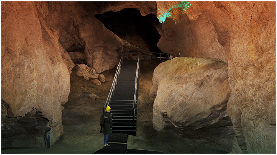
The Sterkfontein Caves, located in the UNESCO World Heritage Site known as the Cradle of Humankind, South Africa, has played an integral role in human origins research and is the richest Australopithecus-bearing site in the world. As the only publicly accessible cave network in the Cradle of Humankind with an ongoing research and excavation programme, the Sterkfontein Caves is an important heritage resource for tourists, educators, students and scientists, contributing to the enrichment of the local economy and South African cultural identity. Ordinarily, tours operate solely through physical engagement with the site, its finds and the underground environment. Multiple recent closures related to Covid-19 and storm damage have highlighted the challenges in maintaining and improving global access to this vulnerable resource. Digitisation of the site was therefore necessary to enable broader access and enhance scientific outreach potential. Archaeological cave sites present challenges in their 3D reproduction due to lighting, complex textures and colours and accessibility. Considering similar projects (e.g. Verdiani Reference Verdiani2015; Cipriani & Fantini Reference Cipriani and Fantini.2017; García-Bustos et al. Reference García-Bustos, Rivero, García Bustos and Mateo-Pellitero.2022; Dutailly et al. Reference Dutailly, Portais and Granier.2023; Karkazi et al. Reference Karkazi2024), where accuracy, scalability and access was valued in digitisation of complex caves with heritage value, we aimed to create a high-quality visual reproduction, while maintaining flexibility in data integration for scientific interrogation. We report here on the initial results of our digital recreation of the largest chamber of Sterkfontein Caves, the Milner Hall (Figure 1).
Photograph of the Milner Hall, taken from the centre of the hall, facing the stairs and exit (photograph by authors).

Methods
Laser scanning in the Milner Hall employed the static terrestrial LiDAR FARO Focus 3D X330, which generated dense point clouds that could be georeferenced to existing ground control (Stratford et al. Reference Stratford, Merlo and Brown.2016) using Global Mapper. One benefit of such data is the resulting high accuracy in the representative spatial form or topology. We created an optimised and georeferenced manifold mesh asset by tessellating these point clouds in PointFuse and processing the resulting mesh in Autodesk Maya (Figure 2). Optimised meshes were modelled to be composed of subdivisible, quad-based surfaces with good edge flow; this allows for precise UV parameterisation (UV here referring to the two axes in a 2D texture space that can be mapped onto the surfaces of a 3D optimised mesh; Maya Autodesk 2023), making advanced texturing possible. It also makes the environment maintainable for future users as technology improves, more research is conducted, and data are added to the platform. The optimised meshes also increase the flexibility and functionality of the platform for visualisation, design and virtual reality.
Georeferenced, retopologised, subdivided and UV’d manifold mesh model of the Milner Hall from the same viewpoint as Figure 1 (figure by authors).

At the site, a series of orthographic high-resolution panoramic photographs were captured from the perspective of the visitor pathways to ensure the highest-quality texture resolution at key angles (processed in Adobe Photoshop). Projective texture mapping was completed referencing these angles and positions using Adobe Substance 3D and Arnold for Maya. The mapping inputs are made up of two blended layers over multiple UV tiles (or UDIMs). The first layer was transferred directly from the high-resolution mesh and included height, ambient occlusion and normal maps. The height and normal maps add the fine detail of the tessellated model’s form without sacrificing performance when used for visualisation. Ambient occlusion improves realism in three-dimensional renders by creating more authentic shadowing. The second layer was created by camera projection matte painting. Transferred colour, position and curvature maps served as a template for matte painting. To produce seamless, high-quality results for all the channels (height, normal and ambient occlusion), orthographic images were used as the base for photogrammetric outputs. In areas of extreme splicing or resolution loss, where accuracy was not prioritised, textures were artistically painted, based on observation. These steps allowed for the creation of a model that replicated the form of the cave to a higher quality and accuracy than is possible with photogrammetry and artistic modelling techniques alone. The globally georeferenced point cloud and excavation datum points were imported using a python script resulting in a consolidated generic file, allowing for easy comparison between the accurate point cloud data and the fully visualised mesh.
Results
Various sample renderings of our results (see also online supplementary material (OSM) video 1) achieved a believable replica in terms of colour and detail (Figure 3). The complex nature of the chamber (see, for example, the stalactite in Figure 3d) made the successful reproduction of the asset challenging. The accuracy of form and spatial features were successfully georeferenced, allowing users to easily identify co-ordinates that align directly to the real space, thereby creating opportunities for interrogation of scientific spatial datasets (such as artefact, fossil, sample and geological or stratigraphic feature locations). The use of the georeferenced data became a useful tool when improving the interoperability between the real and virtual worlds.
Renders of Milner Hall optimised and georeferenced asset: a) centre of hall, facing stairs and exit (compare with Figure 1); b) near exit, facing lake with entrance to right side; c) centre of hall, facing lake and entrance; d) close-up of speleothem and dolomite (figure by authors).

We tested this functionality within Unreal Engine, by creating a digital twin (see OSM video 2) and by redesigning the way visitors navigate the space (see OSM video 3). From this, we noted that the quality of the textures and lighting renders an authentic experience largely due to the advanced texture detailing with the addition of height, ambient occlusion, normal and roughness maps. Having UDIM tiles allows for resolution scaling depending on the purpose. For instance, for online and real-time rendering applications, the textures can be scaled down to a 2K file per UV. In cases where high-quality renderings are needed (animated scientific outreach video sequences, for example), these textures could be exported at 8K per UV. With software and hardware improvements, the resolutions can be scaled higher. As can be observed in Figure 3, the final render can produce several results, with simple tweaks to the texture settings and post-processing effects.
Conclusion
The next steps of this project are to incorporate this environment within Sterkfontein’s public and research digital infrastructure, and to expand the project to include the landscape surface and laboratory, providing an explorable digital site that includes links to archival documents and palaeoanthropological datasets. What makes our data practical is that all optimised layers are accessible, providing a range of accurate data that are easily scaled and visualised by any online visitor. This also allows scientists to quantitatively and qualitatively interrogate spatial excavation and stratigraphic data within a dynamic digital cave environment, and for science communicators to integrate the scientific data into outreach initiatives. With the publication of this article, our dataset is available at https://doi.org/10.5281/zenodo.7821538 (access request required).
Acknowledgements
Gratitude to Mr M. Deacon from PointFuse for his assistance in tessellating the point cloud data and Mr H. Maré for his assistance in providing advice for processing the surfaces using Autodesk Maya.
Funding statement
Support was provided by the National Research Foundation (NRF) of South Africa, the DST-NRF Centre of Excellence in Palaeosciences (DS), the Wits School of Governance: Life in the City Project, WCI Mellon and the University of the Witwatersrand (MS).
Online supplementary material (OSM)
To view supplementary material for this article, please visit https://doi.org/10.15184/aqy.2025.10141 and select the supplementary materials tab.


 Open access