


Introduction
The snow–firn pack is the interface between the atmosphere and the underlying ice and controls the exchange of energy and mass (Reference Brun, Martin, Simon, Gendre and ColéouBrun and others, 1989, Reference Brun, David, Sudul and Brunot1992). Albedo and, hence, ablation are controlled by snow surface characteristics, principally grain size (Reference Grenfell, Warren and MullenGrenfell and others, 1994; Reference Marshall and OglesbyMarshall and Oglesby, 1994; Reference Fily, Leroux, Lenoble, Sergent, Schmitt, Bergh and FestouFily and others, 1998), and the densification of the snow controls trapping of air in the firn and ice (Reference Alley and BentleyAlley and Bentley, 1988; Reference Arnaud, Lipenkov, Barnola, Gay and DuvalArnaud and others, 1998).
Global warming over recent decades has resulted in shrinkage and changes in characteristics of most of the world’s alpine glaciers (Reference Dyurgerov and MeierDyurgerov and Meier, 2000). Snow-pack stratigraphy and the distribution of the different zones of the glacier are basic features which are sensitive to climate change (Reference ShumskiiShumskii, 1964; Reference PatersonPaterson, 1994).
Over the past 45 years, Ürümqi glacier No. 1 (UG1) in northwest China has shrunk by 11%, and the characteristics of its snowpack have changed. Previous studies on this glacier have focused on runoff, mass balance, terminus location and thickness (Reference Li, Han, Jing, Yang and JiaoLi and others, 2003; Reference Yang, Li, Ye, Jiao and ZhaoYang and others, 2005; Reference YeYe and others, 2005; Reference Han, Ding, Ye, Liu and JiaoHan and others, 2006; Reference Jing, Jiao, Yao, Wang and LiJing and others, 2006) but did not investigate long-term changes in the stratigraphy or changes in the spatial distribution of the different zones. In July 2002 a multi-year field campaign was instigated to investigate seasonal changes in the characteristics of the glacier’s snowpack and compare them against historical data. The research was performed as part of the Program for Glacier Processes Investigation (PGPI) carried out by the Tien Shan Glaciological Station (TGS), Chinese Academy of Sciences, since July 2002.
Site Description, Datasets and Observations
UG1 (43˚05′ N, 86˚49′ E), located at the headwaters of the Ürümqi river, in the eastern Tien Shan, northwest China, is a small valley glacier with two branches, east and west. The two branches became separated into two independent glaciers in 1993 as the glacier terminus receded up the valley. In 2001 the total area of the glacier was approximately 1.84 km2. The east branch of the glacier is currently 2.23 km long, with a maximum elevation of 4250 m, while the narrower west branch is approximately 2.54 km long, with a maximum elevation of 4484 m.
Local meteorological data have been recorded from 1958 to 2005 at the Daxigou meteorological station located at 3539ma.s.l., 3 km downstream from the glacier terminus. During the period 1996–2005, the mean annual temperature and precipitation were –5.1˚C and 450.6 mm, respectively. Typically, 90% of the precipitation in this region occurs between May and September. Between 1959 and 2005, the glacier’s equilibrium-line altitude (ELA) was located at an average of 4055 ma.s.l.
Stratigraphic observations of the snowpack have been conducted above the ELA on both branches at elevations of 4068–4150m (where the ice surface slope is about 2–6˚) since 1961. The observations were made according to the International Classification for Seasonal Snow on the Ground (Reference ColbeckColbeck and others, 1990) and included snowpack depth, density, ice and dust layers, grain size and type and temperature. Continuous datasets from more than 120 snow–firn pits were obtained for three periods: 1961–62, 1980–83 and 2002–05 (Table 1).
Table 1. Data series for snow–firn pack on UG1

Results and Discussion
Snowpack stratigraphy
The snow stratigraphy of an alpine glacier reflects processes of snow metamorphism and melt at specific locations on the glacier (Reference ShumskiiShumskii, 1964). Alteration of these characteristics over long time periods can be a direct result of climate change.
Three typical snow stratigraphy profiles of the east branch of UG1 at altitudes of 4068–4150m are shown in Figure 1. Common stratigraphic layers included fresh snow, fine-grained firn, medium-grained firn, coarse-grained firn, dust layers, ice layers and superimposed ice.

Fig. 1. Typical stratigraphic profiles of eastern branch snow–firn pack for the different time periods.
To quantify the variations in the snow–firn pack composition, 120 snow–firn stratigraphic profiles were selected.
They included 26 profiles from the period 1961–62, 34 profiles from 1981–83 and 60 profiles from 2002–05.
Figure 2 shows the average stratigraphic composition of the snow–firn packs. In the period 1961–62 the proportion of coarse-grained, medium-grained and fine-grained firn, fresh snow and other layers (e.g. ice layers, dust layers, depth hoar) accounted for 40%, 25%, 22%, 6% and 7% of the snowpack respectively. In 1981–83, the proportion of the coarse-grained firn layer and medium-grained firn layer increased to 55% and 22%, while the proportion of fine-grained firn decreased from 25% to 12%. By 2002–05 the coarse-grained firn layer had increased to 65% and the proportion of fine-grained firn had continued to decrease, from 12% to 7% between the 1980s and the 2000s.

Fig. 2. Stratigraphic composition of snow profiles for the different time periods.
To summarize, from 1961 to 2005, stratigraphic profiles of the snow–firn pack became less complex, ice layers and ice lenses almost or completely disappeared and coarse-grained firn became the dominant firn type (increasing from 40% to 65%). All of these changes in the snow–firn pack correspond to a warming trend in regional climate, which became more pronounced between 1985 and 2005. The changes in the composition of the snowpack also reflect changes in the distribution of the glacier zones.
Changes in the number of annual layers, percolation and density
Dust and ice layers occur in specific seasons (e.g. spring and summer). This seasonality permits identification of annual layers and hence can be used to date the snow layers. At UG1, Reference Wang, Li, You and LiWang and others (2006) found that one dust layer is preserved in the snow–firn pack per year, as the result of two dust layers merging because of percolation during the summer. Annual layers were thus identified and measured based on single dust layers. Ice layers in the snowpack indicate the presence of small amounts of liquid water. Observations showed that ice layers usually form in spring and summer. In spring, the daytime surface temperature exceeds 0˚C, leading to a partial melting of the snow, and the water refreezes at night, forming an ice layer. In summer, ice layers form when meltwater penetrates downward and refreezes above an impermeable layer such as a layer of glacier ice, or even coarse firn.
Long-term changes in stratigraphy from the three time periods were investigated using historical data collected in 1961–62 and 1980–83 and new data collected in 2002–05. In general, the data suggest that the time required to transform snow into ice has decreased, and the volume of water percolating in the snowpack and the bulk density have increased substantially. For example, between 1961 and 1962 an average of 5.2 dust layers were found in the west branch snowpack (Table 1), suggesting that 5 years of snow accumulation was present above the ice. However, during 1980–83 and 2002–05 the average number of dust layers above the ice (and hence the number of annual layers) was 4.6 and 2.5 respectively. During the same time periods, the average number of dust layers on the east branch decreased from 4.5 to 3.3. The declining number of annual layers identified by the dust suggests that the time required to transform the snow–firn pack into ice has been steadily decreasing.
As well as the decrease in the number of dust layers in the snowpack over the three periods, a decrease was also observed in the number of ice layers. In 1961–62, the west branch contained 7 ice layers, but this decreased to 3.6 and 2 in 1980–83 and 2002–05 respectively. On the east branch, the number of ice layers decreased from 9 to 2.9 over the same period. The decrease in ice layers can be explained by an increase in the percolation of meltwater which destroys the ice layers.
Corresponding to these changes, the average bulk density of the snow–firn pack increased by 20.4% on the west branch and 28.3% on the east branch between 1961–62 and 2001–05.
Snowpack ablation
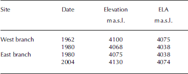
Four long-term stratigraphic observation sites above the ELA were selected to investigate the snowpack response to climate change during spring and summer (Table 2). Snow–firn stratigraphy was recorded every 10 days between May and September in 1962 and 1980 on the west branch and 1980 and 2004 on the east branch.
Table 2. Long- term stratigraphic observation sites on UG1
Snow depth and mean ablation rates for the different time periods are shown in Table 3. The mean ablation rate over the melt season increased at the west branch site by ~26% from 1962 to 1980 and by ~75% from 1980 to 2004 at the east branch site.
Table 3. Changes in snow depth and ablation rate, 1962–2004

The slopes of the linear regression lines in Figure 3 reflect the mean ablation rate of the snowpack during the melt season. We observe that ablation at the west branch site increased between 1962 and 1980, with the regression slope increasing from 0.3 to 0.51. From 1980 to 2004 at the east branch site, ablation can be divided into two periods: 1 May–4 July (days 1–65) (period 1), and 5 July–31 August (days 66–123) (period 2). For period 1, the ablation is remarkably similar from 1980 to 2004, but during period 2 the ablation rate increased significantly, the regression slope increasing from 0.27 to 1.25.

Fig. 3. The temporal development of the snow–firn pack during the melt season (1 May–31 August (days 1–123)) at different times.
Differences in the absorption of solar radiation, determined by slope, surface albedo, aspect and shading, affect glacier ablation rates (Reference Van de Wal, Oerlemans and van der HageVan de Wal and others, 1992). In the period for which there are data for both branches (1980), the slope of the regression line, and hence the ablation rate, is higher for the west branch than for the east branch. The difference is explained by the lower surface slope and shading of the west branch compared to the east branch.
Spatial changes in the glacier zones
The distribution of the glacier’s zones has changed over the past 45 years. Reference Xie, Huang and ShiXie and Huang (1965) found that in 1962 the glacier consisted of four zones from terminus to summit: an ablation zone, an infiltration–congelation zone, an infiltration zone and a recrystallization–infiltration zone (zone classification according to Reference ShumskiiShumskii, 1964). By 1989, the recrystallization–infiltration zone had disappeared, being taken over by the infiltration zone. Meanwhile, the boundaries of all zones moved upward and the accumulation area shrank considerably. By 2004, in addition to the continued change and upward march of the zone boundaries, a small meltwater pool (approximately 30 m2) emerged at the upper end of the east branch (4224ma.s.l.), evidently as a result of air-temperature rise and absorption of solar radiation from increasingly exposed rocks (Reference LiLi, 2005). The appearance of the meltwater pool suggests the melting of UG1 is ongoing at both ends.
Climate change and snow–firn stratigraphy response
Data from the Daxigou meteorological station (3539ma.s.l.) show that the local annual mean temperature increased by about 0.8˚C (95% significance level) between 1959 and 2005. Temperature change was particularly strong after 1997. For example, the summer (June–August) mean temperature ranged from 3.0 to 4.6˚C during 1958–96, and from 4.4 to 5.8˚C after 1997, indicating a step increase of 1.0˚C (Table 3). There was also a strong increase in the annual precipitation rate observed at Daxigou meteorological station. Measurements show an increase of approximately 85 mm (1.9mma–1) or 20.8% over the past 45 years (Reference LiLi and others, 2006). Reference YeYe and others (2005) suggest that one impact of warming (enhanced ablation) tends to overcome the effect of enhanced accumulation through precipitation increase on glacier mass/runoff changes over the last 45 years. We observe that the temperature increase is the main reason for the changes to the snow–firn stratigraphy and the ablation rate on UG1 during the period 1961–2005.
Conclusion
Long-term data were used to determine temporal changes of characteristics of the snow–firn stratigraphy and ablation on UG1.
During the last 45 years, features of snowpack stratigraphy, including depth, structure and composition, were found to be significantly altered by climate warming. In the stratigraphy, the proportion of coarse-grained firn, which is usually formed by infiltration water, was found to have increased from 40% to 65% during the period 1961–2005. The recrystallization–infiltration zone observed in the 1960s turned into an infiltration zone in the 1980s, and a small meltwater pool has emerged at the upper end of the east branch in the 2000s, indicating melting occurring at both ends of the glacier. The mean ablation rate over the melt season increased by ~26% from 1962 to 1980 at the west branch site and by ~75% from 1980 to 2004 at the east branch site.
Acknowledgements
This research was supported by the Knowledge Innovation Project of the Chinese Academy of Sciences (CAS; grants KZCX2-YW-127) and the National Natural Science Foundation of China (grants 40631001, 40571033, 40371028 and J0630966). Support for this research has been provided under the Program for Glacier Processes Investigation (PGPI) conducted by the Tien Shan Glaciological Station, CAS.


