


Introduction
Standing stones (menhirs, statue-menhirs and stelae) are a common feature across Iberia. Several thousand of these monuments have been recorded; displaying a diversity of sizes, forms, arrangements, functions and locations, their use spans six millennia, from the Neolithic to the Middle Ages (c. 5400 BC–AD 1500). ‘Warrior’ and ‘diademated’ stelae (the latter also referred to as ‘stelae with headdress’) are found in south-western Iberia and are traditionally dated to the Bronze Age (c. 2200–850 BC) and Iron Age (c. 850–200 BC) (for catalogues and syntheses see Celestino Pérez Reference Celestino Pérez2001; Harrison Reference Harrison2004; Díaz-Guardamino Reference Díaz-Guardamino2010). For decades, the interpretation of those two groups of stelae has been hampered by the lack of clear contextual information resulting first, from the fortuitous nature of most finds and second, from the lack of fieldwork undertaken at the find spots. While various anecdotal, fragmentary and unverified reports are discussed in the literature, suggesting a link with burial practices and/or a role as landmarks, no indisputable evidence existed to confirm or disprove such claims (Díaz-Guardamino Reference Díaz-Guardamino2010: 31–35; García Sanjuán et al. Reference García Sanjuán2025).
In this article, we present new evidence demonstrating that both warrior and ‘diademated’ stelae served both as grave markers and territorial landmarks associated with trackways. This evidence stems from the newly discovered burial site of Las Capellanías, located in the municipality of Cañaveral de León (Huelva province, south-west Spain), partly below the Las Capellanías road (Figure 1). The site lies at a short distance (around 100km) from other locations where Bronze Age and Iron Age stelae have been discovered, particularly across the lower Guadalquivir Valley and middle Guadiana basin (Sevilla, Córdoba, Badajoz and Ciudad Real provinces), as well as southern Portugal. These stelae have traditionally been classified, according to the motifs present on them, in three main categories: ‘Alentejan slabs’ (restricted to southern Portugal and showing panoplies of weapons), ‘warrior stelae’ (with or without a presiding anthropomorphic figure) and ‘diademated stelae’ (displaying a prominent, headdress-like motif over the head). However, this classification system does not take into account parameters such as location, context, shape/size of the slab, chronology or geology. The discoveries at Las Capellanías challenge such classification, emphasising the importance of location, context and chronology when studying stelae.
Location map of Las Capellanías, also showing Al Idrisi’s itinerary between Sevilla and Badajoz (twelfth century AD) and the main Bronze Age and Iron Age sites mentioned in the text (figure by Timoteo Rivera Jiménez & Leonardo García Sanjuán).

Figure 1 Long description
A detailed map of Iberia highlighting the location of Las Capellanas. The map also traces Al Idrisi’s twelfth-century AD itinerary between Sevilla and Badajoz. Key Bronze Age and Iron Age sites mentioned in the text are marked. The map uses color gradients to represent elevation and terrain features, with various geographic locations labeled. The map is designed to provide historical and archaeological context for the region.
Three stelae have been found at Las Capellanías—the first by chance, the other two during excavations. Two have already been published in detail (#1 and #2; Rivera Jiménez et al. Reference Rivera Jiménez2021; García Sanjuán et al. Reference García Sanjuán2025). Upon the accidental discovery of stela #1 in the spring of 2018, a joint research project by the universities of Durham, Gothenburg, Huelva, Sevilla and Southampton was launched to record the stela and investigate its context. Between 2019 and 2021, surface surveys were undertaken in an area of around 5km around the find spot. In June 2022 and September 2023, excavations were conducted at the site, followed by extensive post-excavation analysis of the stelae and associated finds, including restoration, optically stimulated luminescence (OSL) and radiocarbon dating, and bioarchaeological and archaeometric analyses. While the grave associated with stela #2 has been discussed previously (García Sanjuán et al. Reference García Sanjuán2025), an overview of the Las Capellanías burial complex is presented here for the first time. This contextual information helps settle a debate that has occupied the literature on Iberian stelae for more than a century.
Burial structures
Excavations carried out in June 2022 and September 2023 in a square of 1250m2 revealed 18 burial structures and several more were identified in the surrounding area through geophysical survey (ground penetrating radar and magnetometry) (Figure 2; see also online supplementary material (OSM)). Eight structures were excavated in full; three were largely intact (#7, #12 and #14), the others exhibiting varying degrees of damage by modern or ancient looting (#1a, #1b, #4, #6 and #8). Based on their architecture, three categories of graves were identified.
Plan of the site, showing the location of the stelae (figure by Timoteo Rivera Jiménez and Leonardo García Sanjuán).

Figure 2 Long description
The image presents a detailed plan of an archaeological site, highlighting the locations of three stelae labeled as Stela 1, Stela 2, and Stela 3. The plan includes various structures numbered from Structure 1 to Structure 14, with additional annotations such as a trackway and magnetometric survey areas. Each stela is depicted with an inset image showing its design and inscriptions. The site plan also features measurements in meters, providing a scale for the layout. The magnetometric survey areas are outlined and filled with dotted lines, indicating regions of interest. The overall layout suggests a complex archaeological site with significant historical artifacts and structures.
Structures #1a, #1b and #4 are cist-type tombs consisting of rectangular pits cut into bedrock, lined with vertical slate slabs and originally covered by horizontal slate slabs. In south-western Iberia, these cists were common in the Early and Middle Bronze Age (c. 2200–1550 BC). Structures #1a and #1b were built within structure #1, a circular cairn (5.82m in diameter) made of green ophite pebbles and white quartz blocks, held together by a ring of upright slabs. Structure #1a (2.31 × 0.34 × 0.46m) unusually large for a Bronze Age cist and made of purple slate, was completely empty, containing no grave goods or bones. About 0.50m to the north-east of structure #1a, stela #2—depicting a warrior with weapons—was found inserted upside down in the mound. Structure #1b (1.55 × 0.85 × 0.56m) (Figure 3A) lies parallel and just south of #1a. It contained two ceramic vessels—an inverted, empty La Cruz del Negro type urn and another containing cremated human bone (minimum number of individuals (MNI) = 1)—and a bronze double-spring fibula. The isolated structure #4, 12m south-east of structure 1, is a small, damaged cist (0.75 × 0.35 × 0.49m), still partially lined by slate slabs but missing its capstones. It yielded eight beads and a bronze toiletry set, but no human remains.
Photogrammetric renderings of structures #1b, (A) #6 (B, right) and #8 (B, left) (figure by Timoteo Rivera Jiménez).

Figure 3 Long description
The image displays photogrammetric renderings of archaeological structures. Image A shows a rectangular pit labeled #1b, lined with vertical slate slabs and containing two pottery vessels. Image B shows two structures, with the right one labeled #6 and the left one labeled #8. Structure #6 appears to be a rectangular pit with stone lining, while structure #8 is less distinct but also seems to be a pit with stone boundaries. Both images include measurement scales and markers for orientation.
Structures #6, #7 and #8 are slab-lined and cairn-covered pits, a distinct funerary type known from the Iron Age, particularly in southern Portugal. These tombs consist of roughly rectangular pits cut into the bedrock, not lined with vertical slabs but surrounded by small horizontally laid ones, then covered with capstones and a stone cairn. The best-preserved example is structure #7 (Figure 4), located just north-west of structure #1, beneath the trackway. It consists of an elongated pit (1.9 × 0.8m) covered by purple slate capstones and surrounded by a rectangle (3 × 1.75m) of smaller, horizontally laid slabs. Above this lay a cairn of mixed lithology—white quartz, green ophite, blue-green slates—together weighing about 609kg. The pit contained two large Chardón-type vessels and a high-shouldered bowl, all handmade (see description of material culture below). One vessel held cremated human remains (MNI = 1), charcoal, small bronze items (possibly fibula parts) and pieces of a silver earring. Structures #6 and #8 lie about 15m east of structure #7, directly beneath the track surface (Figure 3B). Both are in poor condition, probably looted but have similar chamber sizes (1.2–1.5m long), delimited by horizontal slabs about 2m long. Structure #6 yielded a small Late Iron Age falcata-type iron knife and cremated bone (MNI = 1). Structure #8 contained a bronze spring fibula, a rectangular iron plate and cremated bone (MNI = 1). Stela #1 stood near structure #6.
Photogrammetric renderings of structure #7 through the excavation process (figure by Timoteo Rivera Jiménez).

Figure 4 Long description
The image displays a series of photogrammetric renderings of structure #7 at various stages of the excavation process. The renderings show the arrangement of stones in different configurations, highlighting the changes in the structure as excavation progresses. Each rendering provides a detailed view of the stones’ positions and the overall layout of the structure.
The third category of burial architecture includes composite structures. Located 6m west of structure #1, structure #12 (Figure 5A–C) has a complex layout subdivided into #12a, #12b and #12c. Substructure #12a is an oval pit (2m across, 0.9m deep) surrounded by small slate slabs, ophite pebbles and white quartz, arranged radially in the north and longitudinally in the south. It contained the largest assemblage of cremated human bone (958.6g, MNI = 2: one adult and one adolescent), together with a glass teardrop pendant, a spherical bead, a copper bead, pottery sherds and clay fragments. Substructure #12b, adjacent and partly overlapping #12a, is also oval (1.5m across, 0.6m deep) and delimited by slate slabs, it was filled with small pottery fragments, charcoal and cremated bone (MNI = 1). Stela #3 partially covered its northern half. Substructure #12c, further west and subcircular, was not excavated but slate, ophite and quartz were identified within its fill—materials extending beneath the northern ring of substructure #12a.
Photogrammetric renderings of structures #12 (A, B & C) and #14 (D, E & F) through the excavation process (figure by Timoteo Rivera Jiménez).

Figure 5 Long description
Photogrammetric renderings of structures 12 and 14 through the excavation process. The image shows six different stages of excavation for two distinct structures, labeled A, B, and C for structure 12, and D, E, and F for structure 14. Each stage reveals different layers and arrangements of stones, highlighting the progression of the excavation. The renderings provide a detailed visual representation of the archaeological process, showcasing the gradual uncovering of these ancient monuments.
To the north of structure #1 lies structure #14 (Figure 5D–F), separated by structure #13 (a circular unexcavated feature). Structure #14 is a shallow quadrangular pit (1.23m wide) lined with one stone row and sealed by eight large slate slabs (526kg total). Inside, a single large (approximately 0.40m tall) wheel-thrown Chardón-type urn was found, lying horizontally and containing abundant cremated bone (626.3g, MNI = 1).
Grave goods
The excavated burials yielded seven ceramic vessels (four in structure #7, two in structure #1b and one in structure #14), displaying differences in manufacture and morphology (Figures 6 & 7). All four vessels found in structure #7 were handmade, while those from #1b and #14 were wheel-thrown. The assemblage reflects mixed cultural practices, with the coexistence of local Bronze Age ceramic traditions (handmade Chardón-type vessels and high-shouldered bowl) and pottery types introduced by the Phoenicians in the ninth century BC (wheel-thrown La Cruz del Negro type urns). The mixed morphologies, with shapes known in the Late Bronze Age (c. 1550–850 BC) and others newly introduced through connections with the eastern and central Mediterranean (e.g. La Cruz del Negro type urn), aligns Las Capellanías with other well-known sites in southern Iberia (see discussion below).
Ceramic vessels and urns found at Las Capellanías (figure by Juan José Lupión Álvarez).

Figure 6 Long description
The image displays various ceramic vessels and urns discovered at the Las Capellanías archaeological site. These artifacts include different types of urns and vessels, each with unique shapes and sizes. The vessels are shown with detailed drawings and photographs, highlighting their distinct features and craftsmanship. The urns and vessels are labeled with their respective structures and measurements, providing context for their archaeological significance.
Ceramic vessels and urns from: A) structure #7; B) structures #1b (left) and #14 (right) (photographs by Miguel Ángel Blanco de la Rubia).

Figure 7 Long description
The image contains two sets of ceramic vessels. The first set, labeled A, includes four broken vessels from structure number 7. These vessels are displayed in a fragmented state, with visible cracks and missing pieces. The second set, labeled B, includes three vessels from structures number 1b and 14. These vessels are also displayed in a fragmented state, with visible cracks and missing pieces. The vessels vary in shape and size, showcasing different designs and levels of preservation. The photograph captures the intricate details of the ceramic vessels, highlighting their historical and archaeological significance.
In addition, a fragment of decorated, handmade pottery was found on the surface during the 2022 campaign, while clearing the cairn of structure 1 (Figure 8). This fragment presents incised lines in two registers: below the lip of the vessel undulating lines cut across each other to form oval shapes resembling eyes, and below this are a series of parallel vertical lines. This decoration has not previously been found in western Sierra Morena (see below).
A) A sherd of decorated handmade pottery found while clearing the cairn of structure #1 (the fragment is 75mm high); B) painted wheel-thrown pottery fragment with a similar motif from La Mota (Valladolid); C) incised hand-thrown pottery fragment with a similar motif from Escuela de Hostelería, Mérida (Badajoz) (A: photograph by José Ruiz Flores; B: after Blanco García Reference Blanco García, Rodríguez González and Celestino Pérez2019: 199, fig. 15:2; C: after Jiménez Ávila & Heras Mora Reference Jiménez Ávila, Heras Mora and Jiménez Ávila2017: 119, fig. 8).

Figure 8 Long description
The image contains three distinct pottery fragments. The first is a sherd of decorated handmade pottery, 75 millimeters high, found while clearing the cairn of structure number one. The second is a painted wheel-thrown pottery fragment with a similar motif from La Mota in Valladolid. The third is an incised hand-thrown pottery fragment with a similar motif from Escuela de Hostelería in Mérida, Badajoz. Each fragment showcases unique decorative patterns and craftsmanship.
The metal finds (Figure 9B) consist largely of prestige goods produced and circulated within a regional framework. Structure #7 yielded remains of one silver ‘arracada’ (earring of ‘crest’ type), comparable to those recently recorded in Extremadura and Portugal (see Nogueira et al. Reference Nogueira2021). These objects emulate larger and more elaborated gold jewels, such as those from the ‘Aliseda Treasure’ (Rodríguez Díaz et al. Reference Rodríguez Díaz2019). Bronze ornaments include the complete double-spring fibula found inside one of the urns in structure #1b and the ‘Tartessian’-type belt buckle also from structure #1b. Despite its poor preservation, the buckle can be identified as a passive half with coiled terminals, probably fitted with two hooks. A fragmentary bronze ring-type fibula from structure #6 represents a typical Early Iron Age (c. 850–550 BC) prestige item, which was found together with a falcata-type iron knife. The slightly later chronology of these artefacts coincides with the radiometric dates obtained for this tomb (see below). Structure #4 yielded a bronze toiletry set (Jiménez Ávila & Lorrio Alvarado Reference Jiménez Ávila and Lorrio Alvarado2019) consisting of one stylet and two small knives, all decorated with fine incised lines. In the same tomb, small bronze clamps may indicate one or more boxes or coffers. This assemblage is the richest so far excavated at the site and it is possible that a fibula was also deposited in this tomb, though only the pin has survived.
A) Beads: numbers 1 to 5 and 8 to 10 from structure 4; numbers 6 and 7 from structure 12. B) Drawings of metal objects: 1) silver crest-type earring (structure 7) (approximate scale); 2) bronze double-spring fibula (structure 1b); 3) bronze ‘Tartessian’-type belt buckle (structure 1b); 4) bronze ring-type fibula (structure 6); 5) Falcata-type iron knife (structure 6); 6) bronze toiletry set (stylet and two small knives) (structure 4) (photograph by David Wheatley; drawings by Marisol Crespo Ros).

Figure 9 Long description
Section A of the image features ten beads, each with distinct colors and forms. The beads are labeled from one to ten. Beads one to five and eight to ten are from structure four, while beads six and seven are from structure twelve. Section B presents six detailed drawings of metal objects. These include a silver crest-type earring from structure seven, a bronze double-spring fibula from structure one b, a bronze Tartessian-type belt buckle from structure one b, a bronze ring-type fibula from structure six, a Falcata-type iron knife from structure six, and a bronze toiletry set, including a stylet and two small knives, from structure four. The photograph is credited to David Wheatley, and the drawings are by Marisol Crespo Ros.
Eight glass and carnelian beads were recovered from structure #4 (Figure 9A), alongside a coarsely worked stone pendant. Two are black fusiform beads with inlays that contribute to the ongoing debate concerning this type of manufacture in south-west Iberia (Gomes Reference Gomes2021; Lončarić et al. Reference Lončarić2024). Isolated glass ornaments are also present in tombs #1b and #12a. A distinctive teardrop-shaped glass pendant (Figure 9A, no. 7) was recovered from substructure 12a—an uncommon form in Iberian archaeology but comparable to artefacts from other Mediterranean areas—alongside an annular-spherical glass bead and a copper bead.
Bioarchaeology
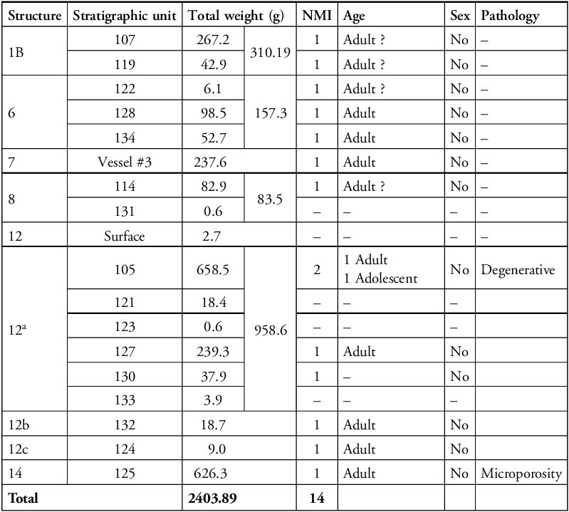
Demographic information for the cremated human remains from structures #1b, #6, #7, #8, #12 and #14 is shown in Table 1. Almost 2.5kg of cremated material was collected, though the quantity of bone found in each structure varied greatly, ranging from 85.5g in structure #8 to 958.6g in structure 12a. Anatomical regions are unevenly represented in the cremated material (using reference values proposed by Gonçalves Reference Gonçalves2012) and do not match what would be expected from complete individuals. This may be explained by the looting and/or reuse of some burials (#1b, #6, #8 and possibly #12), or by the selective recollection of the bones after cremation, as these burials are clearly secondary in nature with the original place of cremation unknown. All fragments present a homogeneous brownish colour, suggesting firing temperatures between 285 and 525°C, with only a few examples of calcined fragments. However, bone colour may be influenced by variables other than temperature, so these results must be viewed with caution.
Summary of demographic data.

Table 1 Long description
The table presents demographic data of cremated human remains from structures numbered 1B, 6, 7, 8, 12, and 14. It includes columns for structure, stratigraphic unit, total weight in grams, NMI, age, sex, and pathology. The table has 14 rows and 7 columns. The total weight of cremated material collected is 2403.89 grams, with individual structure weights ranging from 2.7 grams to 958.6 grams. The NMI values vary, with some structures having multiple entries. Age is categorized as adult or adolescent, with some entries marked as uncertain. Sex is mostly unspecified, and pathology notes include degenerative conditions and microporosity.
In total, a minimum of 14 individuals are identified. Most structures contained only one individual, with the exception of structures #1b (MNI = 2), #6 (MNI = 3) and #12 (NMI = 6). No specific age estimations or sex determinations could be made. The observation of pathological bone was constrained to the identification of slight articular and non-articular degenerative disease in bones from structure #12a (SU 105) and possible porosity on a cranial fragment from structure #14 (SU 125).
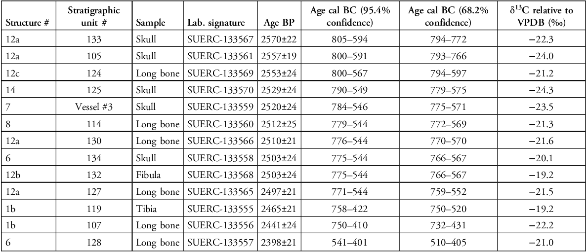
Relative measurements of stable carbon isotopes (δ13C) were obtained as part of the radiocarbon dating process (Table 2). The δ13C values range between −19.2 and −24.3‰, with an average of −21.6‰, compatible with a marine fish-based diet (Nash et al. Reference Nash2011), although the closest access to the sea would have been more than 100km away (via a then-present marine bay into which the Guadalquivir River emptied, near modern-day Seville). Some individual values are also compatible with a diet based on C3 plants but δ15N data are not available to qualify this.
Summary description of radiocarbon dates. All dates were calibrated using OxCal 4 (Bronk Ramsey Reference Bronk Ramsey2021) and the IntCal20 atmospheric calibration curve (Reimer et al. Reference Reimer2020).

Table 2 Long description
The table presents data on radiocarbon dates and stable carbon isotope measurements from various samples, including skulls, long bones, and other bones. It includes columns for structure number, stratigraphic unit number, sample type, lab signature, age before present (Age BP), calibrated age ranges (Age cal BC at 95.4% and 68.2% confidence), and delta 13C values relative to VPDB. The table has 14 rows and 8 columns, with each row providing detailed measurements for specific samples. Notable trends include the range of delta 13C values between 19.2 and 24.3, with an average of 21.6, indicating a diet compatible with marine fish or C3 plants.
Radiocarbon dating
A set of 13 radiocarbon dates were obtained on cremated bone (Table 2). The dates are largely coherent, suggesting a ‘compact’ chronology for the cremation burials, ranging between c. 800 and 550 cal BC (at 95.4% confidence), corresponding to the Early Iron Age. Only one sample (SUERC-133557) returned a later date; this sample corresponds to structure #6, in which a falcata-type iron knife typical of the Late Iron Age was found.
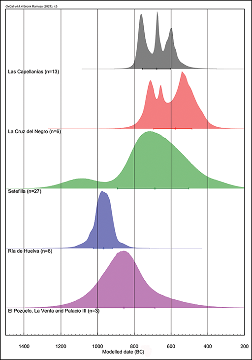
A Bayesian model produced using the ChronoModel software (Lanos & Dufresne Reference Lanos and Dufresne2024) narrows down this chronology, offering a start date between 836 and 609 BC and an end date between 706 and 453 BC (at 95.4% confidence), or a start date between either 810 and 713 BC (53%) or 708 and 672 BC (15%) and an end date between 638 and 519 BC (at 68.2% confidence). The dated cremations display a duration ranging from 0–304 years (95.4%) or 9–205 years (68.2%), with activity likely peaking around 620 BC. In general, the chronology of the cremation burials at Las Capellanías corresponds with the early stages of the Phoenician and Greek presence along the Mediterranean and Atlantic coasts of Iberia, which is represented by sites like La Joya, La Cruz del Negro and Setefilla, all within 100km from Las Capellanías (Figure 10). This chronology must be understood within the context of what appears to be a long history of activity at Las Capellanías, as two OSL dates obtained from soil samples taken from below stela #2 yielded ages between the late third and mid-second millennia BC (García Sanjuán et al. Reference García Sanjuán2025). Therefore, it is likely that the dated cremations represent a later stage in the history of the site.
Kernel density estimate of the Las Capellanías radiocarbon dates as compared with other coeval sites in south-west Spain (figure by Francisco Sánchez Díaz).

Figure 10 Long description
The graph displays several normal distribution curves, each representing radiocarbon dates from different archaeological sites in south-west Spain. The x-axis represents modeled dates in BC, ranging from 1400 to 200 BC. The y-axis represents the density of the dates. The curves are color-coded and labeled with site names: Las Capellanas, La Cruz del Negro, Setefilla, Ria de Huelva, and El Pozuelo, La Venta and Palacio III. Each curve shows the distribution of dates for the respective site, with peaks indicating periods of higher activity. The curves vary in shape and height, reflecting differences in the dating evidence from each site. The graph provides a comparative visual representation of the chronological data from these sites.
Discussion
Debate surrounding the function of Iberian ‘warrior’ and ‘diademated’ stelae has persisted due to a lack of precise, high-quality contextual data. The investigations at Las Capellanías demonstrate that both types of stelae are associated with burials, used as markers for burials and for pathways (as revealed for megaliths by Murrieta-Flores Reference Murrieta-Flores2012). Stela #1 was found next to structure #6, stela #2 was found embedded in the mound of structure #1 (next to structure #1a) and stela #3 was found partly covering structure #12. All stelae were also closely connected to the Las Capellanías trackway: stela #1 was found beneath the road, stela #2 was discovered on its edge and stela #3 barely six metres to the south. The trackway is likely to have been used since at least the Middle Age, as it corresponds almost exactly with the itinerary set by the twelfth-century AD geographer Al Idrisi between the cities of Sevilla and Badajoz, in the lower Guadalquivir Valley and middle Guadiana basin respectively (see Figure 1) (Rivera Jiménez et al. Reference Rivera Jiménez2021). A statistically significant association has also been found between traditional rural pathways and drovers and the location of megalithic monuments in the region (Murrieta Flores Reference Murrieta-Flores2012).
The analysis of engraved motifs and assessment of stelae ‘types’ are beyond the scope of this article (for a discussion, see Rivera Jiménez et al. Reference Rivera Jiménez2021; García Sanjuán et al. Reference García Sanjuán2025), yet two general features of the Las Capellanías stelae stand out. First, the chronology, potentially spanning from the early second to the mid-first millennia BC. While the two OSL dates obtained from soil underneath stela #2 provide maximum ages in the first half of the second millennium—a time frame consistent with the architecture of structure #1, in which this stela was embedded—the radiocarbon chronology of the cremations places structures #6 and #12 largely within the Early Iron Age. As stela #3 was found partly overlaying structure #12, its use (or reuse) may be contemporaneous to or postdate the ages provided by the cremated bones found within the structure (early eighth to mid-sixth centuries BC). While there is still much work to be done regarding the chronology of these stelae, Las Capellanías provides the first secure empirical evidence to frame the discussion—and future research.
The second notable feature is the iconography, certain aspects of which place this site within a broader network of connections extending to the lower and middle basins of the Guadalquivir, Guadiana and Tagus rivers. These connections are evident in the depiction of a possible fibula and/or comb over the right shoulder of the human figure. This motif appears on all three stelae from Las Capellanías and on stelae from Torrejón Rubio 2 (Tagus), Fuente de Cantos (Guadiana) and Ategua (Guadalquivir). The specific way of depicting the warrior’s body on stela #2 from Las Capellanías is also observed on stelae from Burguillos (Guadalquivir), Fuente de Cantos (Guadiana) and Aldeanueva de San Bartolomé (Tagus). Further, the presence of a bow and arrows on stela #2 aligns it with a small group of ‘warrior’ stelae that includes examples from São Martinho 2 in the middle Tagus basin, from Capilla 3, Alamillo, El Viso 1 and six other examples located in the middle Guadiana basin, and from Torres Alocaz, Cuatro Casas/Carmona, Montemolín and Écija 3 in the lower Guadalquivir Valley (see Díaz-Guardamino Reference Díaz-Guardamino2010 for detailed descriptions). It can be no coincidence that the main parallels for stelae #1 and #2 are located in the neighbouring Guadalquivir and Guadiana valleys, once connected by the Las Capellanías road.
A long period of construction, use and frequentation is also suggested by the adjacency of the burial structures and their formal variability. The architecture of the burials suggests a gradual ‘beehive’-type pattern of growth, with an early ‘foundational’ construction (structure #1) to which others were gradually attached ‘centrifugally’. The best example of this adjacency pattern is recorded between structures #7, #13 (unexcavated) and #14; the outer limits of these structures were carefully constructed to be in contact without overlapping or breaking into each other. This suggests a diachronic and sequential pattern of conscious (and careful) expansion of the burial area, which, given the relatively short radiocarbon chronology, may have occurred over the course of a few years or decades. The formal diversity of the burials echoes practices documented in the Early Bronze Age (cists) and in the Late Bronze Age and Early Iron Age (Chardón and La Cruz del Negro type vessels used as cremation urns). This reveals Las Capellanías as a place of hybridisation, and ‘glocalisation’ where different cultural inputs—local and ‘global’, were blended into a larger whole: a large necropolis monumentalised with stelae. A similar situation was noted for the Almargen stela, in Málaga (Díaz-Guardamino et al. Reference Díaz-Guardamino2020). It is impossible not to connect this phenomenon with the location of the necropolis upon a major communication route.
In terms of architecture and spatial organisation, multiple sites are analogous to Las Capellanías. These are typically characterised by cists or pits surrounded and covered by stone cairns, like structure #1, and delimited by rings of vertically placed slabs. Limiting the scope of the comparison to the south-western quadrant of Iberia, and based on published radiocarbon dates and associated material culture, analogous architecture can be found at necropolises dating to the final centuries of the third millennium BC and first half of the second, like Atalaia, Alfarrobeira, La Traviesa (Early and Middle Bronze Age), Provença, Corte Cabreira, Pessegueiro and Quiteira or Vale da Telha and Nora Velha (and maybe some structures in Atalaia) dating to the Late Bronze Age and Early Iron Age) (see summary discussion in García Sanjuán et al. Reference García Sanjuán2025). Many of these Late Bronze Age and Early Iron Age necropolises follow a formal pattern already found in the Early Bronze Age (Jiménez Ávila Reference Jiménez Ávila2003). As at Las Capellanías, their chronology is complex, with periods of persistent use occurring over long stretches of time. Yet these necropolises also differ from Las Capellanías in many ways—especially regarding the presence or absence of stelae and of certain aspects of material culture.
In terms of material culture, the La Cruz del Negro-type wheel-thrown urn found in structure #1b provides a link between Las Capellanías and the eponymous necropolis located in Carmona (Seville), in the lower Guadalquivir Valley, some 140km to the south-east. La Cruz del Negro type urns have been found in Early Iron Age burials across southern Iberia, including the Spanish Levant (Fernández & Moriel Reference Fernández and Moriel1984), Málaga province (Sánchez Bandera et al. Reference Sánchez Bandera2001) and southern Portugal (Gomes Reference Gomes2018). The three Chardón-type vessels retrieved from structures #7 and #14 also align Las Capellanías with other Late Bronze Age and Early Iron Age burial sites in southern Spain, including Setefilla (Sevilla), also in the lower Guadalquivir Valley, where a ‘warrior’ stela was found covering a grave in one of the burial mounds (Aubet Reference Aubet1997). Another stela of the same type was later discovered at the site of Mirasiviene, just 3km to the east from Setefilla (Díaz-Guardamino et al. Reference Díaz-Guardamino2019). Only a few comparable examples have been found for the incised sherd retrieved from the top of structure #1 (Figure 8). One comes from La Mota (Valladolid), in the north of the Spanish central plateau, where a wheel-thrown vessel with a similar painted motif, considered a ‘southern import’, was dated to the sixth–fifth centuries BC (Figure 8B; Blanco García Reference Blanco García, Rodríguez González and Celestino Pérez2019: 199, fig. 15:2). A handmade vessel retrieved in Mérida (Badajoz) provides an incised example dated to the Early Iron Age (Figure 8C; Jiménez Ávila & Heras Mora Reference Jiménez Ávila, Heras Mora and Jiménez Ávila2017: 119, fig. 8). The metal artefacts and beads found at Las Capellanías match the typical repertoire of grave goods in ‘Orientalising’ (i.e. dating to the Early Iron Age, when sustained Aegean and Levantine cultural influence was brought to Iberia) necropolises of the Iberian south-west, particularly those with less prominent burials dated to around the seventh century BC.
These material parallels draw a map of connections than run from the lower Guadalquivir Valley, across the middle Guadiana basin towards northern Spain, echoing the geographical distribution of ‘warrior’ stelae (Díaz-Guardamino et al. Reference Díaz-Guardamino2020) and the long-distance route connecting south-western and north-western Iberia that the Las Capellanías trackway was part of in the Middle Ages (Rivera Jiménez et al. Reference Rivera Jiménez2021). Thus, the burials at Las Capellanías materialise the communication role this route probably played even in second and first millennia BC. The possible marine diet of some of the individuals buried there between the eighth and sixth centuries BC is probably not unrelated to this, revealing coastal connections and lifestyles.
The broad geographical scope revealed by the architecture, iconography and material culture of Las Capellanías corresponds with the temporal persistence of the site. This can be seen, for instance, in the presence of a La Cruz del Negro cremation urn, usually associated with Phoenician cultural influence, in a cist likely to have been built in the Early Bronze Age and then reused in the Early Iron Age. Early second-millennium tradition and early first-millennium innovation appear to have blended effortlessly at Las Capellanías. Radiocarbon dates on human bone reveal the reuse of old megalithic monuments during the Late Bronze Age/Early Iron Age in the surrounding Huelva and Sevilla provinces, as in the case of La Venta and El Pozuelo (Nocete Calvo et al. Reference Nocete Calvo and Nocete Calvo2004), about 40km to the south, and Palacio III, 60km to the east (García Sanjuán Reference García Sanjuán, Celestino Pérez and Jiménez Ávila2005; Murillo-Barroso et al. Reference Murillo-Barroso2015) (Figure 10). Therefore, Las Capellanías was not the only ancestral site being reused in the early centuries of the first millennium BC. At this time, exceptional metallurgical and commercial activity was taking place in the Riotinto mining district and the Huelva province more generally. This activity triggered powerful ‘Orientalising’ cultural developments along the Atlantic coast of Huelva, best reflected at the necropolises of La Joya (Huelva city) and Hoya de los Rastros (Ayamonte) (Blanco-González et al. Reference Blanco-González2023). It is unlikely that the cremations found at Las Capellanías were unrelated to this phenomenon.
Conclusion
The excavations at Las Capellanías have revealed temporal persistence, geographical connectivity and cultural hybridisation in burial architecture and artefacts. These investigations provide valuable and novel data for understanding the social and cultural context of the use of prehistoric stelae in Iberia like no other before; and for expanding existing knowledge about associations between communication routes and monuments (see Murrieta-Flores Reference Murrieta-Flores2012). Located upon an ancient trackway, Las Capellanías opens new horizons for the analysis of interactions between local and ‘foreign’ people between the tenth and sixth centuries BC, a period of intense cultural exchange connected with the burgeoning mining, smelting and trading occurring in the Huelva province and the wider region of south-western Iberia.
Acknowledgements
We are grateful to several people who collaborated in the fieldwork carried out as part of this study, including Rosa Otero Béjar, from the Huelva Regional Cultural Board, and Mercedes Gordo Márquez, Miguel Muñoz Sánchez and Luisa Conejo Olivo from the Cañaveral de León city council for their continued support throughout. We also thank Judit Praena García, Manuel Tristán Martín Ruiz and Itzel Duarte González, undergraduate students at the University of Sevilla, and Kalliopi Hadjipateras, Robert Lanigan, Huang Qinghuan, Thea Lewin, Ellie Newton, Ian Wong, Pandu Ilalang and Amelia Holden, undergraduate students from Durham University.
Funding statement
This study was funded by the following institutions: Maritime Encounters Project of the University of Gothenburg (Sweden), Riksbankens Jubileumsfond (RJ) (Grant number M21-0018), Durham University (UK), Research Group ATLAS (HUM-694) of the University of Sevilla (Spain), the University of Southampton (UK) and the City Council of Cañaveral de León (Huelva, Spain).
Online Supplementary material (OSM)
To view supplementary material for this article, please visit https://doi.org/10.15184/aqy.2026.10369 and select the supplementary materials tab.
Author contributions: CRediT categories
Timoteo Rivera Jiménez: Conceptualization-Lead, Data curation-Lead, Formal analysis-Lead, Funding acquisition-Lead, Investigation-Lead, Methodology-Lead, Project administration-Lead, Resources-Lead, Software-Lead, Supervision-Lead, Validation-Lead, Visualization-Lead, Writing - original draft-Lead, Writing - review & editing-Lead. Marta Díaz-Guardamino: Conceptualization-Lead, Data curation-Lead, Formal analysis-Lead, Funding acquisition-Lead, Investigation-Lead, Methodology-Lead, Project administration-Lead, Resources-Equal, Supervision-Lead, Visualization-Lead, Writing - review & editing-Equal. David W. Wheatley: Formal analysis-Lead, Funding acquisition-Lead, Investigation-Lead, Methodology-Lead, Software-Lead, Supervision-Lead, Validation-Lead, Visualization-Lead. José Antonio Lozano Rodríguez: Formal analysis-Lead, Investigation-Lead, Methodology-Lead, Writing - review & editing-Equal. Raquel Montero Artús: Data curation-Lead, Formal analysis-Equal, Investigation-Equal, Methodology-Equal, Writing - review & editing-Equal. Lucy Shaw Evangelista: Formal analysis-Lead, Investigation-Lead, Methodology-Lead, Writing - review & editing-Equal. José Ruiz Flores: Investigation-Supporting, Resources-Equal, Visualization-Equal, Writing - review & editing-Supporting. Juan José Lupión Álvarez: Data curation-Supporting, Investigation-Supporting, Visualization-Equal. Javier Bermejo Meléndez: Investigation-Equal, Methodology-Equal, Writing - review & editing-Equal. Javier Jiménez Ávila: Data curation-Equal, Formal analysis-Equal, Investigation-Equal, Methodology-Equal, Writing - review & editing-Equal. Florian Cousseau: Formal analysis-Equal, Investigation-Equal, Methodology-Equal, Writing - review & editing-Equal; Johan Ling: Conceptualization-Equal, Funding acquisition-Lead, Project administration-Lead, Writing - review & editing-Equal. Francisco Sánchez Díaz: Formal analysis-Equal, Investigation-Equal, Methodology-Equal, Writing - review & editing-Equal. Leonardo García Sanjuán: Conceptualization-Lead, Data curation-Lead, Formal analysis-Equal, Funding acquisition-Equal, Investigation-Lead, Methodology-Equal, Project administration-Lead, Resources-Lead, Supervision-Lead, Validation-Lead, Visualization-Lead, Writing - original draft-Lead, Writing - review & editing-Lead.




 Open access

