


Introduction
In recent decades, researchers have challenged depictions of the 1532 Spanish invasion and subsequent colonisation of the Andes that emphasise sudden rupture and immediate totalising change (e.g. Lamana Reference Lamana2008; Bray Reference Bray2019; VanValkenburgh Reference VanValkenburgh2019). This scholarship demonstrates that the creation of Spanish sovereignty was an extended process (e.g. Covey Reference Covey2020), reveals how Andean people resisted Spanish impositions and incorporated Spanish material culture into long-standing practices (e.g. Norman Reference Norman2019; Hu Reference Hu2022), and tracks how pre-Hispanic Inka rule shaped subsequent Spanish interventions (e.g. Wernke Reference Wernke2013). This work shows that understanding the consequences of the Spanish invasion requires attending to the complexity and contingency of colonial rule, including the political underpinnings of socioenvironmental continuity and transformation. In this article, I examine the consequences of Spanish colonialism in the Andes by querying ecological changes at Ollantaytambo, in the Cusco region of Peru. My approach follows scholars who emphasise that colonialism is an enduring structural imposition (e.g. Wolfe Reference Wolfe2006; Dedrick et al. Reference Dedrick, McAnany and Batún Alpuche2023), archaeologists who examine the persistent ecological consequences of colonial and imperial rule (e.g. Langlie Reference Langlie2018; Morrison Reference Morrison2018; Rosenzweig & Marston Reference Rosenzweig and Marston2018), and researchers who highlight the ways in which Andean landscapes and ecologies shape the social practice of agriculture and the political constellations through which land is managed (Zimmerer Reference Zimmerer1991; Erickson Reference Erickson, Balée and Erickson2006; Wernke Reference Wernke2013; Grant & Lane Reference Grant and Lane2018; Hunter & Huamán Mesía Reference Hunter and Huamán Mesía2023). For the latter group of scholars, the non-human environment shapes human action, even as it is also recursively constituted through practices such as agricultural labour; as such, landscapes and ecologies are shaped by sociopolitical communities who are responsive to broader political changes, including colonialism. I bring these perspectives together to query the timing and form of lasting structural changes to agroecology at Ollantaytambo following the Spanish conquest. Clarifying these processes elucidates the specific social processes through which colonial rule worked lasting ecological change in the region.
Ollantaytambo is one of a string of archaeological sites arrayed along the Urubamba River that were royal estates of the Inka Empire (c. AD 1400–1532, see Figure 1). These estates were the personal possessions of individual Inka rulers. They included opulent palaces, pleasure gardens, elaborate waterworks, game preserves and sprawling agricultural complexes (Niles Reference Niles1999; D'Altroy Reference D'Altroy, Alconini and Covey2018; Quave Reference Quave, Alconini and Covey2018). As at other estates, the Inka built a dramatic anthropogenic landscape of terraces and walled fields at Ollantaytambo to generate the yields of maize, tubers and other crops that undergirded imperial authority (Kosiba Reference Kosiba, Alconini and Covey2018). Spanish rule—and attendant changes in the administration of land, the introduction of new flora and fauna, new tributary and labour demands, and the creation of a new colonial political economy oriented around the extraction of tribute—produced both incremental and sudden shifts in the region's ecology. Yet, even as the Inka-built landscape was clearly reshaped under Spanish rule, it is not immediately obvious when practices of land use changed at Ollantaytambo, nor how social and governmental shifts reverberated through the local agricultural landscape. How did the sudden interruption of Inka rule, the availability of new plants and animals, and the institution of new modes of labour organisation (i.e. colonial conscription) change how people living around the estate used and maintained Ollantaytambo's terrace system? When did these changes initiate structural transformations within that agrarian system? What social processes prompted those shifts in land management?
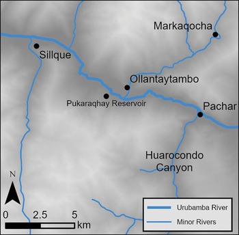
Inset) map of Peru; main map) Urubamba Valley region of Cusco, indicating locations of select Inka royal estates along the Urubamba River (figure by author).

In this article, I draw on data from excavations at a derelict Inka-era reservoir, in conjunction with published palaeoenvironmental data and archival research, to consider these questions. These data indicate significant regional agricultural deintensification at Ollantaytambo around the close of the sixteenth century AD. I conclude by discussing factors that likely contributed to this deintensification.
The Inka estate at Ollantaytambo
The core of the Ollantaytambo Inka estate is a palace and temple complex at the confluence of the Patacancha and Urubamba rivers (Protzen Reference Protzen1992). Inka-built fields radiate out from this complex through those valleys and onto adjacent terraced hillsides (Figure 2); colonial-era land claims and the distribution of Inka-era sites suggest an area stretching from Pachar in the east to Sillque in the west, and from the Sondor Valley in the south to Markaqocha in the north, was associated with the estate (Kosiba & Hunter Reference Kosiba and Hunter2017; Hunter Reference Hunter2021; see Figure 3). Analysis of agricultural land in the region demonstrates that many of the estate's fields were planned and built as part of a cohesive agricultural system (Kosiba Reference Kosiba and Bray2015, Reference Kosiba, Alconini and Covey2018). Inka workers terraced hundreds of hectares, and protected those fields with kilometres of retaining walls that channelled the Urubamba and Patacancha rivers. Many of these fields were articulated via elaborate extended canal networks; such fields were managed together to ensure the appropriate distribution of water, nutrients and labour required to make the land productive (Kosiba Reference Kosiba, Alconini and Covey2018).
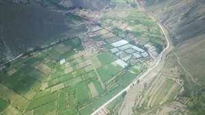
Drone photo of Inka-built walled fields and terraces emanating from Ollantaytambo's urban core and lining the Urubamba River (figure by author).

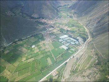
The Ollantaytambo region (figure by author).

At Ollantaytambo, the form of the agricultural system structures agricultural practices. Terrace fields retain solar energy and shed frost, modulate the flow of water and level planting surfaces, thereby shaping planting sequences and the seasonal allocation of labour. At the same time, this agricultural system requires constant maintenance and upkeep—activities that demand regional co-ordination and supra-local political organisation. Thus, the intensification of production at Ollantaytambo under Inka rule created an elaborate environmental structure that required regional co-ordination to facilitate day-to-day agricultural practices (i.e. planting and irrigation schedules), routine maintenance of canals and terraces, and repair of acute damage to those infrastructures. Within an ideological system that predicated political authority on the ability to provide, the Inka reinforced their claims to power over people and land by managing these processes (Kosiba Reference Kosiba, Alconini and Covey2018). Indeed, fields, buildings and other infrastructures were located within the region to reinforce and naturalise social distinctions between Inka elites and their subjects (Kosiba & Bauer Reference Kosiba and Bauer2013). How, then, was this landscape transformed when Spanish colonial rule replaced Inka governance?
Colonial transformation of the Ollantaytambo terrace system
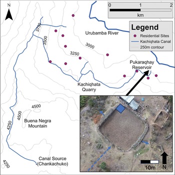
To understand how the shift from Inka to Spanish Colonial governance reverberated through Ollantaytambo's agricultural system, I turn to stratigraphic and sedimentary evidence from an Inka-era reservoir within a field complex on the southern hillside of the Urubamba Valley. The Pukaraqhay reservoir is the terminus of a defunct 15km canal system that originates in a high-altitude plain, circumnavigates a steep mountain and descends from west to east along the southern wall of the Urubamba Valley (Figure 4). Along this trajectory, the canal passes through multiple archaeological sites dating to the Inka and pre-Inka periods and above numerous terrace complexes arrayed on the hillside of the Kachiqhata region. When in use, the canal—and associated reservoirs, including Pukaraqhay—required regular maintenance and cleaning to remove accumulated silt. These activities demanded co-ordination between farmers arrayed along the length of canal, connecting people who lived and worked in distinct communities. When this maintenance stopped, the canal continued to deposit sediment in the reservoir until it too ceased to function. Thus, excavating in reservoir sediments is, in effect, to explore the process of infrastructural dereliction on the southern hillside of the Urubamba Valley.
Kachiqhata canal trajectory from the source in the Chankuchuko plain to the Pukaraqhay reservoir. Inset: drone photo of the reservoir showing water inflow and outflow directions (blue arrows) and excavation location (blue square) (figure by author).

Excavations in the Pukaraqhay reservoir were conducted in collaboration with local landowners and the Asociación de Productores Agrícolas de Simapuqio, an agrarian co-operative that manages nearby fields. A 2 × 2m unit was placed in the corner of the reservoir opposite the intake, where sediments were least likely to be perturbed as they settled. This unit was excavated in 50mm arbitrary increments. Excavators collected all cultural and organic material encountered during excavations, as well as 6l bulk soil samples for macroremain analysis and separate 250ml sedimentary samples for pollen analysis (following Bryant & Holloway Reference Bryant and Holloway1983).
Reservoir stratigraphy
The reservoir was excavated to a depth of approximately 1.50m below the contemporary surface, or 2.50m below the height of the reservoir wall and datum (Figure 5). A thick layer of compact sterile clay 0.75m below surface marks the bottom of the reservoir during the period of Inka use. Immediately above this, a 0.40m matrix of near-uniform semi-compact silt comprises sediment that accumulated in the reservoir after regular maintenance ceased (Inka/colonial deposits). Local farmers report that several centimetres of sediment accrue annually in comparably sized reservoirs, so this accumulation may represent only a few decades of infilling. A caprid mandible—one of only a few identifiable bone fragments recovered from the sequence—confirms that sediments above the clay reservoir bottom were deposited in the colonial era, likely after the middle of the sixteenth century when non-native fauna became common in the region.
Stratigraphy of excavations in the Pukaraqhay reservoir, indicating locations of dated samples and datum on the reservoir wall (figure by author).

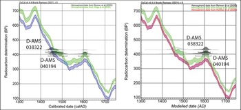
A series of radiocarbon dates from the reservoir sequence offer further temporal precision. Of these dates, two [D-AMS 038322, D-AMS 040194] are from the stratum of concern. Overlap in the calibrated date ranges of these two samples further confirms that the upper silty strata in the reservoir accumulated rapidly. Other dates [D-AMS 038323, D-AMS 038324], from lower in the sequence, are considerably earlier and are assumed to be from unrelated phases of reservoir construction, which seemingly mixed together Inka- and underlying Formative-era material (2200 BC–AD 200; see Figure 5). Table 1 provides calibrated date ranges for all samples using both the SHcal20 curve and a bespoke curve mixing the SHcal20 curve and the IntCal20 curve to account for seasonal atmospheric mixing between northern and southern hemispheres in the Andes (Marsh et al. Reference Marsh, Bruno, Fritz, Baker, Capriles and Hastorf2018; see Ogburn Reference Ogburn2012 on mixed curves; see Hogg et al. Reference Hogg2020 and Reimer et al. Reference Reimer2020 for curve data). The use of such mixed curves is increasingly common in the Andes (Lane & Marsh Reference Lane and Marsh2023; Arkush et al. Reference Arkush, McCool and Smith2024). The bespoke curve and associated OxCal code used here was developed by Lane and Marsh (Reference Lane and Marsh2023) for Machu Picchu; given the proximity of that site to Ollantaytambo (approximately 30km) I reproduce the Machu Picchu curve exactly.
Radiocarbon dates from the Pukaraqhay reservoir. The upper two rows are from the stratum deposited in the Colonial era. All dates were calibrated using OxCal v.4.4.4 (Bronk Ramsey Reference Bronk Ramsey2009). Upper stratum dates were modelled assuming deposition in the Colonial Era (AD 1533–1822).

Fluctuations in the radiocarbon curve in the sixteenth and seventeenth centuries introduce bimodal distribution to calibrated probabilities. As a result, calibrations return a wide range of possible dates at the 95.4% certainty level (Table 1, Figure 6). The introduction of Bayesian priors—here, colonial deposition signalled by the presence of introduced fauna in the sequence—enables elimination of the bimodal issue through the creation of a terminus post quem model using the OxCal ‘After’ function. With assumed deposition after 1532—the earliest possible introduction of non-native caprids—the model returns a high probability that the silty stratum was deposited at the end of the sixteenth or beginning of the seventeenth century AD. The range of possible dates is especially narrow at the 68.3% level of probability. This result suggests that the canal and reservoir were maintained for more than half a century following the collapse of Inka rule, well into the colonial era.
Distribution of calibration probabilities for Inka/Colonial samples from the Pukaraqhay reservoir. Scale bars indicate 95.4% and 68.3% probabilities. Left) unmodelled calibration using SHcal20 curve, note bimodal distribution; right) modelled distribution with mixed curve, note elimination of bimodal distribution (figure by author).

Botanical analysis
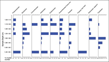
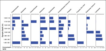
Botanical samples from the reservoir provide indicators of changing agricultural practices as the reservoir silted in. Both pollen samples and macroremains were analysed by Luis Huamán Mesía at the Palynology and Palaeobotany Lab at the Universidad Peruana Cayetano Heredia in Lima. Macroremain analysis procedures are reported in Hunter and Huamán Mesía (Reference Hunter and Huamán Mesía2023). Pollen samples were processed following Traverse (Reference Traverse1988) and were spiked with a known quantity of Lycopodium spores to facilitate concentration calculations. Pollen counts were targeted to a minimum of 200 grains per sample, but in several samples the total number of grains counted was under 200 (Huaman Reference Huaman2019; see Figure 7). This may limit the degree to which pollen counts from those samples represent the plant community surrounding the reservoir.
The composition of pollen assemblage counted (Lycopodium spike counts at far right), plotted against depth, in metres, from unit datum. Deposition likely began c. AD 1600 (figure by author).

Pollen results
Pollen grains were either brought to the reservoir via the canal or fell directly onto the reservoir surface (‘pollen rain’). The assemblage thus reflects plants directly surrounding the reservoir, plants from the high plains and hillsides traversed by the canal, and, in the case of widely dispersed high pollen producing taxa, the broader region. Pollen concentrations in the sequence are low overall, in line with expected concentrations in dry soils rather than saturated contexts (e.g. Dimbleby Reference Dimbleby1985). Because of this, I provide both the relative percentages and pollen concentrations in each sample (Figures 8 & 9). Pollen grains are susceptible to repeated desiccation and saturation, so poor preservation may be due to the wet/dry cycle of Andean seasonality. Low pollen counts and variable concentrations mean these data should be approached with caution. As such, I draw conclusions from pollen data only where findings are supported by independent datasets, including macroremains, published environmental proxies and the archival record.
Percentages of major pollen groups in counted assemblage plotted against depth, in metres, from unit datum. Deposition likely began c. AD 1600 (figure by author).

Concentrations of major pollen groups in counted assemblage, with Lycopodium spike plotted against depth, in metres, from unit datum. Deposition likely began c. AD 1600 (figure by author).

The Pukaraqhay pollen sequence suggests both regional and localised ecological transformations during the colonial era. No taxa are ubiquitous throughout the sequence, although Cheno-Ams (species from either the Chenopodium or Amaranthus genera) appear at all depths except 1.40–1.45m. Alnus (alder) was the second most ubiquitous pollen, present in six of the eight samples. This ubiquity likely reflects both the prevalence of alder in the landscape and the high production and wide, wind-blown dispersal of pollen from this taxon. Podocarpus, Solanum and Poaceae pollen are also present in most samples, although at highly variable concentrations. Solanum pollen may represent any of a wide range of Andean taxa. Though it is not possible to definitively identify its source, Solanum tuberosum (potato) and other native tubers are commonly dry-farmed in the vicinity of Pukaraqhay today. If the Solanum pollen in the sequence is from S. tuberosum, the presence of maize pollen in the earliest sample and Solanum in subsequent strata may indicate a shift in cultivation practices from maize to tuber growing. As maize cultivation at Ollantaytambo demands significant infrastructural investment to ensure both irrigation and field drainage, this shift in the pollen assemblage may signal a change in the management of fields surrounding the reservoir or along the path of the canal that precluded maize cultivation. The sequence does not indicate a dramatic drop off in wide-dispersing regional tree cover, suggesting silt was deposited prior to broad regional deforestation in the seventeenth century (Chepstow-Lusty & Winfield Reference Chepstow-Lusty and Winfield2000). However, the proportion of pollen from herbaceous taxa—in lower depths largely Cheno-Ams and in later samples Poaceae, Solanaceae and Asteraceae—increases over time. Many of these taxa—particularly the Asteraceae—are ruderals that colonise recently disturbed soils or uncultivated fields, and so their presence may indicate erosion or the conversion of land into pasture (e.g. Brugger et al. Reference Brugger, Gobet, Osmont, Behling, Fontana, Hooghiemstra, Morales-Molino, Sigl, Schwikowski and Tinner2019).
Macroremain results
Macroremains recovered from the reservoir are predominantly charred seeds, which were likely deposited following fires in adjacent fields. Macroremains occur at overall densities ranging from 0.615 to 10 elements per litre of sediment. The overall density of these remains trends upwards over time, perhaps indicating more frequent fires in the surrounding area. Plants represented in the assemblage include cf. Xylopia sp., Parahancornia sp.—both fruit-bearing genera common at elevations lower than Ollantaytambo—and Celtis sp. (deciduous hackberries). Seeds of Tilesia, small plants with distinctive yellow flowers that establish rapidly in disturbed or eroded soils, increase in density through the sequence, perhaps indicating increasingly unstable soils over time. The sequence also contains a single carbonised seed of Solanum, further suggesting that that taxon was cultivated around the reservoir as it silted in (Figure 10).
Macroremains raw counts (top) and densities (bottom) by depth. Deposition likely began c. AD 1600 (figure by author).

The presence of lower-altitude tree species in the seed assemblage is difficult to interpret. Sixteenth-century cadastral surveys reference a nearby Inka ‘guerta’ (garden or orchard), perhaps indicating that Inka farmers maintained special conditions around the reservoir to grow exotic fruits (Biblioteca Nacional del Perú (BNP), Manuscritos B-1030, 1629). Such a garden would have required particular care to maintain a microclimate suited to lower-elevation plants. Given that preservation conditions were likely stable across the relatively short period represented by the Pukaraqhay sequence, and that overall macroremain density increases over time, the absence of lower-elevation pollen and macroremains from the upper levels of the reservoir suggest either a significant change in anthropogenic deposition or the disappearance of these taxa from the landscape as the reservoir silted in.
Discussion
Collectively, these data indicate that the infrastructural system to which the Pukaraqhay reservoir belonged broke down around the turn of the seventeenth century, and that this transformation was associated with agroecological shifts in the surrounding landscape, including a possible shift from maize to potato cultivation on nearby fields, the neglect of fields that required special care and repurposing of cultivated land into pasture. In short, infrastructural dereliction and agricultural deintensification. Records from historic cadastral surveys at Ollantaytambo support this interpretation. In 1594, fields surrounding the reservoir were described as cultivable land, suited for producing maize and potatoes (BNP, Manuscritos B-1030, 1629). In 1659, however, the same fields were listed as “tierras de poco fruto”, poorly productive lands upon which little could be cultivated (Archivo Regional de Cusco (ARC), F: Colegio Ciencas, L: 26, f. 115–115v).
Comparison with findings from a stratigraphic core extracted from a wetland called Markaqocha, approximately 10km from Ollantaytambo up the Patacancha Valley, enables regional extrapolation of data from Pukaraqhay. The Markaqocha core indicates a landscape that was less intensively managed under colonial rule than in the Inka period, characterised by increasing rates of erosion, fire (possibly to clear fields, see Chepstow-Lusty et al. Reference Chepstow-Lusty2009) and deforestation—likely the combined result of colonial demands for timber and the collapse of Inka edicts protecting estate forests (Chepstow-Lusty & Winfield Reference Chepstow-Lusty and Winfield2000; Chepstow-Lusty et al. Reference Chepstow-lusty, Frogley, Bauer, Leng, Cundy, Boessenkool and Alain2007). In addition, an increase in the concentration of oribatid mites in the Markaqocha core—a proxy for animal grazing—is aligned temporally with the turn of the seventeenth century, likely reflecting animal introductions at this time (Chepstow-Lusty Reference Chepstow-lusty2011). In sum, the Markaqocha data suggest a similar suite of ecological transformations at the regional scale as data from the Pukaraqhay reservoir suggest more locally: a shift in land management around the close of the sixteenth century that resulted in large-scale agricultural deintensification. Again, Spanish colonial land evaluations confirm this trend. Between surveys in 1594 and 1629, land use changes in fields across the valley floor and hillside terrace complexes led colonial surveyors to declare approximately half the cultivated land surrounding Ollantaytambo vacant or underused (see Kosiba & Hunter Reference Kosiba and Hunter2017). The delay in the structural transformation of the local agrarian system indicated in the Pukaraqhay stratigraphy and chronology suggests that many aspects of the Inka agroecology at Ollantaytambo, including expansive irrigation systems and terrace complexes, continued to be used by local farmers well into the colonial period. Seemingly, farmers who once worked under Inka domination continued to maintain elaborate infrastructures for generations after the collapse of Inka bureaucracies. In turn, this result indicates that farmers sustained the social cohesion required for upkeep of the agrarian system long after the collapse of centralised Inka authority.
This finding of complex agrarian organisation independent of centralised authority reinforces moves by researchers in the Andes to challenge neo-Wittfogelian theories linking complex agricultural infrastructures and a top-down administrative state (e.g. Mayer Reference Mayer2002; Erickson Reference Erickson, Balée and Erickson2006 ). It also prompts questions: why did land use tend towards deintensification around the end of the sixteenth century? Why were some infrastructures that underpinned intensive cultivation allowed to deteriorate at that juncture? Why did land managers value these fields differently within the context of a transforming colonial political ecology?
In some respects, the timing of transformations in land use at Ollantaytambo is unsurprising. Until roughly the 1570s, Spanish colonisers made few incursions into rural areas and governed through a policy of indirect rule that depended on the authority of local lords. That said, simply linking agroecological transformation to more direct Spanish rule at the close of the 1500s is insufficient to understand why land use changed when it did. Rather, sociopolitical shifts associated with colonialism need to be linked to specific changes in agricultural practice. In the Andes more broadly, researchers have correlated agricultural deintensification during the colonial period with factors such as the climatic cooling of the Little Ice Age, depopulation and the reorganisation and resettlement of agrarian workers by the Colonial State (see discussion in Wernke Reference Wernke2010; Plekhov et al. Reference Plekhov2021). These factors are certainly relevant to the Ollantaytambo case study: the community was consolidated into a single tributary town in the 1570s, even as the Little Ice Age reduced altitudinal production limits—perhaps by as much as 80m for some crops—and the population dramatically decreased (Glave & Remy Reference Glave and Remy1983; Kosiba & Hunter Reference Kosiba and Hunter2017). As demography and climate have been discussed elsewhere, I focus here on additional factors that, given the archival record, likely had a disproportional influence in reshaping Ollantaytambo's colonial ecology: namely, newly available plants and animals combined with new modes of land governance.
The introduction of non-native plants and animals fundamentally altered the constraints of production at Ollantaytambo, in the process shifting ecological strictures in place during the era of Inka land management. For instance, the availability of wheat—which can be grown with minimal irrigation and on steeper slopes than maize—expanded the area of land that could be planted with high-value grain crops. Some farmers at Ollantaytambo responded by shifting away from maize cultivation, curtailing the need to maintain irrigation infrastructures, or claiming new lands on previously uncultivated hillsides (Kosiba & Hunter Reference Kosiba and Hunter2017). The value of wheat within the emerging colonial political economy also shifted production incentives. Indeed, the Ollantaytambo kuraka, or town leader, collaborated with Spanish colonists to farm wheat commercially between the 1550s and the 1570s (Burns 1999; BNP, Manuscritos A-300). Where wheat cultivation replaced maize, the lower water requirements of the introduced crop may have discouraged the maintenance of irrigation systems.
Introduced animals like pigs, cattle and caprines also shifted agricultural strictures, including by offering modes of production that required less intensive labour inputs. Husbandry of introduced animals became common around Ollantaytambo at the close of the sixteenth century. By the 1590s there were no fewer than 10 estancias in the region, the majority owned and operated by Spanish colonists (Hunter Reference Hunter2021). These ranches kept thousands of animals. In the high reaches of the Sillque Valley, for example, an erstwhile Inka noble named Carlos Inka kept hundreds of cattle and perhaps as many as 3000 sheep. Such herds were not ecologically benign. Andean farmers often complained that animals threatened traditional cultivation practices as they roamed; for instance, in 1608 an Andean noble who grew tubers in high altitude fields above Ollantaytambo complained that Spanish-owned animals were encroaching on his planted fields (ARC, Benficencia Publica, L:46, f:222). Introduced animals also actively contributed to the dereliction of field systems; as they grazed on terraces and drank at canals, they destabilised slopes and toppled retaining walls. Indeed, indicators of increased erosion and pasturing in the Markaqocha core align with the 1594 establishment of an estancia at that site (ARC, Colegio Educandas, L:02). Similarly, the dereliction of the Pukaraqhay reservoir was coincident with the creation of an estancia for keeping goats along the Kachiqhata canal (ARC, Protocolos Notariales N:260, 1618). Grazing on hillside fields would have actively damaged irrigation infrastructures and terraces, and would have disincentivised field maintenance, ultimately rendering some fields unsuited for intensive cultivation. Importantly however, introduced taxa did not influence production on all fields equally; broad and flat fields on the valley floor may have increased in value relative to hillside fields as they were more suited to the newly available technological complex of the ox and plough (Hunter Reference Hunter2021).
The establishment of grazing estancias points to another major structural transformation in the colonial era: the consolidation of privatised ownership over Ollantaytambo's fields. Spanish colonists began claiming land at Ollantaytambo in the 1550s, but these claims accelerated in frequency and expanded in area dramatically in the 1590s (Amado González Reference Amado González1998; Hunter Reference Hunter2021). Ultimately, landholding consolidated in the hacienda system of land management, which concentrated land and social power in the hands of a few individuals by the late 1600s. The proliferation of privatised landholding in the late sixteenth century would have fractured the social organisation required to maintain complex agricultural infrastructures. For instance, land along the canal that feeds the Pukaraqhay reservoir was divided into at least four parcels in the late sixteenth century, including three held by Spaniards and one by a group of Andean people from a distant region (ARC, Protocolos Notariales, N:260, 1618; BNP, Manuscritos B-1030, 1629). Fragmented ownership would have made the co-ordination of maintenance difficult, contributing to the silting of the reservoir, the cessation of canal function and agricultural shifts towards dry farming. Indeed, evidence suggests that the consolidation of landholding at Ollantaytambo by privately held haciendas in the seventeenth century cemented colonial transformations to the region's ecology. Haciendas devoted their most fertile lands to commercial maize production and allocated other lands to worker subsistence or pasturing hacienda herds. As Hunter and Huamán Mesía (Reference Hunter and Huamán Mesía2023) point out, the circumstance of servitude likely disincentivised intensive agriculture for worker subsistence. In this sense, the consolidation of colonial property holding marked a comprehensive restructuring of Ollantaytambo's agrarian system, even as Inka-built infrastructures continued to undergird hacienda production.
Conclusion
Data from Ollantaytambo highlight the delayed onset of structural transformations to the Andean regional environment brought about by Spanish colonialism. Substantial agricultural deintensification did not begin in earnest until the close of the sixteenth century: a juncture associated with the reorganisation of peasant communities, mass demographic transformation, the proliferation of introduced agricultural taxa and the expansion of individualised possession of the fields around Ollantaytambo. These findings highlight that the Spanish ‘conquest’ of the Andes, while initiated in 1532, was drawn out and historically contingent. More tellingly, they suggest that the Andean community at Ollantaytambo independently maintained a significant portion of the elaborate Inka field system around the town through the first half-century of colonial rule. At Ollantaytambo farmers maintained complex infrastructures indelibly linked to a powerful state apparatus for their own ends after collapse of that bureaucracy. Indeed, it is notable that the consolidation of more centralised control under Spanish rule corresponds with agricultural deintensification and the dereliction of agrarian infrastructures. As Wernke (Reference Wernke2010) highlights, deintensification is an inherently political process. At Ollantaytambo, eroding terraces and fields were not the inevitable result of colonial rule, rather, they were the result of decisions about land use made, increasingly, by Spanish landowners. Hence, the structural transformation of Ollantaytambo's agrarian system can be understood both as part of a global wave of environmental change initiated by colonialism in the sixteenth century, and as a situated response by agriculturalists to changes to Ollantaytambo's local political ecology under colonial rule. In this sense, shifts in the ecological system initiated by colonial land management demonstrate the mutual construction of ecology and society at Ollantaytambo; the ‘nature’ of the agrarian system was, and is, fundamentally a social construct.
Acknowledgements
The author is especially grateful to the Asociación de Productores Agrícolas de Simapuqio and Justo Ccaywa for supporting and collaborating on fieldwork, and to Eliana Vera and Dr Luis Huaman for critical research support. Special thanks to Steve Kosiba for sharing transcriptions of several historical documents, to Jesus Galiano and Alex Usca Baca for archival assistance, and to Mudit Trivedi for assistance with radiocarbon modelling. The author is deeply appreciative of thoughtful comments from two anonymous reviewers.
Funding statement
This research was funded by a National Science Foundation Doctoral Dissertation Research Improvement Grant (#1834850) and a grant from the Rust Family Foundation (RFF-2018-60).
Online supplementary material (OSM)
To view supplementary material for this article, please visit https://doi.org/10.15184/aqy.2024.200 and select the supplementary materials tab.
Archival resources
The archival resources cited in this article are listed below. These documents are held at the Archivo Regional de Cusco (ARC) and the Biblioteca Nacional del Perú (BNP).
ARC. Colegio Educandas, Legajo. 02, 1568–1722. Venta de tierras en Pire y Marcacocha.
ARC. Beneficencia Publica, Legajo. 46. Tierras y moxones cerca de pachar.
ARC. Colegio Ciencias, Legajo. 26, 1555–1725. Salvador de Mora vecino del pueblo de Ollantaytambo…solicitando amparo de los terrenos que poseía.
ARC. Protocolos Notariales, N:260, 1618–1619. Testigo Luis Vizente.
BNP. Manuscritos A-300, 1581. Cargos que el ylustre señor capitán Albaro de Mendoça corregidor e juez (Archivo Libros Raros).
BNP. Manuscritos B-1030, 1629. Expediente Sobre La Peticion presentada por el Licenciado Luis Enriquez.


 Open access