


The edge of the Uinta Basin in northwestern Colorado marked the upper limits of Formative agriculture in the Middle Rocky Mountains. The region was a frontier for the eastern Fremont archaeological tradition, a loose collection of part-time foragers and farmers based primarily in Utah during the first millennium AD (Madsen and Simms Reference Madsen and Simms1998; Simms Reference Simms2008; Spangler Reference Spangler, Madsen and Metcalf2000). Archaeologists have long been interested in classifying Fremont culture variants because of their economic, artistic, and social diversity over time (e.g., Allison Reference Allison, Harry and Roth2019; Gunnerson Reference Gunnerson1969; Janetski and Talbot Reference Janetski and Talbot2014; Kidder Reference Kidder1924; Madsen and Simms Reference Madsen and Simms1998; Marwitt Reference Marwitt1970; Morss Reference Morss1931; Spangler Reference Spangler, Madsen and Metcalf2000). Today, most researchers agree that the Fremont encompassed a spatiotemporal patchwork of immigrant farmers from the Southwest, as well as in situ foragers, hunters, and horticulturalists who practiced flexible mobility patterns.
Fremont archaeology in northwestern Colorado closely parallels that of eastern Utah, with shared material traditions such as thin-walled grayware ceramics, Uinta side-notched arrow points, one-rod-and-bundle basketry, and composite corncob-stick artifacts (Baker Reference Baker1998a; Burgh and Scoggin Reference Burgh and Scoggin1948; Creasman Reference Creasman1981; Hauck Reference Hauck1993; Holmer and Weder Reference Holmer, Weder and Madsen1980; Wenger Reference Wenger1956). Fragments of unfired clay figurines found across the region resemble the iconic trapezoidal anthropomorphic rock art of the Uinta Basin (Lister Reference Lister1951; Wenger Reference Wenger1956). Basic settlement and food-storage strategies are similar, featuring hamlet-style habitations (Baker Reference Baker1998a; Creasman Reference Creasman1981; LaPoint et al. Reference LaPoint, Davidson, Creasman and Schubert1981), beehive-shaped corn granaries tucked into canyon ledges (Baker Reference Baker1997; Wenger Reference Wenger1956), and defensive structures built along cliffside prominences (Baker Reference Baker1998b; Bauer Reference Bauer2022; Biela et al. Reference Biela, Meyer and LaBelle2022; Creasman and Scott Reference Creasman and Scott1987; LaPoint et al. Reference LaPoint, Davidson, Creasman and Schubert1981). However, the eastern frontier also shows distinctive local variation. The study area lacks semisedentary farming villages; most habitations represent rural single-family households and short-term occupations (Baker Reference Baker1997; Creasman Reference Creasman1981; Gardner and Gardner Reference Gardner, William, Roth and McBrinn2016; Gardner, Hadden, et al. Reference Gardner, Gardner and Lammers2020). Regional rock art blends Classic Vernal and San Rafael styles (Cole Reference Cole1987; Creasman Reference Creasman1981), and some radiocarbon dates suggest that the frontier was a late Fremont refuge up to the 1600s (Creasman and Scott Reference Creasman and Scott1987).
The existing 1,500-year radiocarbon chronology for Fremont sites in Colorado is a composite of many different types of dated events and sample types (Reed and Metcalf Reference Reed and Metcalf1999:109–130). In this article, we reframe a chronological analysis of the Fremont by focusing on a single facet of their subsistence economy: maize horticulture. We argue that it is problematic to assume that the total sample of Fremont radiocarbon dates mirrors the specific chronology of small-scale farming; the decision to incorporate cultigens into Fremont diets likely responded to specific needs to supplement foraged resources based on demographic and climatic changes (Barlow Reference Barlow2002; Finley et al. Reference Finley, Robinson, DeRose and Hora2020; Madsen and Simms Reference Madsen and Simms1998; Vernon et al. Reference Vernon, Yaworsky, McCool, Spangler, Brewer and Codding2024; Yaworsky et al. Reference Yaworsky, Vernon, McCool, Hart, Spangler and Codding2024). Ebbs and flows in the horticultural chronology may have operated at different temporal scales than did other variables influencing change within Fremont lifeways. Thus, our approach to modeling the chronology of corn horticulture solely uses dates of corn macrofossils and of storage features used to cache cultivated foodstuffs. Our methods are consistent with other recent cultigen-specific chronologies emphasizing dataset hygiene and direct links to farming intensification and diffusion (e.g., Adair et al. Reference Adair, Duncan, Young, Bozarth and Lusteck2022; Filipović et al. Reference Filipović, Meadows, Corso, Kirleis, Alsleben, Akeret and Bittmann2020; Finley et al. Reference Finley, Robinson, DeRose and Hora2020; Hart Reference Hart2022; Solheim Reference Solheim2021).
We first unpack the radiocarbon chronology by applying basic chronometric hygiene protocols to sites containing corn samples and granary features in northwestern Colorado. We carefully consider the context of these materials and the behavioral implications suggested by corn deposition within sites. We then construct an accurate chronology of corn horticulture and crop storage by developing a site-specific Bayesian age model that addresses the beginning and end of corn farming in the region. We conclude with a complementary analysis of the summed probability distribution (SPD) of calibrated dates to better understand the temporality (peaks, dips, and plateaus) of these agricultural practices and to address potential systemic biases related to sampling errors.
Our results support a region-wide pattern of corn farming intensification between the late tenth and early twelfth centuries AD, comparable to peak farming and community formation practices observed throughout the Uinta Basin and West Tavaputs Plateau (Barlow Reference Barlow2002; Finley et al. Reference Finley, Robinson, DeRose and Hora2020; Hart et al. Reference Hart, Brenner-Coltrain, Boomgarden, Brunelle, Coats, Metcalfe and Lewis2021; Spangler Reference Spangler, Madsen and Metcalf2000; Yaworsky Reference Yaworsky2021). However, in northwest Colorado, the Fremont’s approach to cultivation differed from those of other established farming communities by maintaining mobile rural lifeways without ever forming dedicated farming hamlets and pithouse villages. In addition, our analysis of maize cultigens and granaries does not support the extended “Late Fremont” chronologies commonly attributed to eastern Fremont sites in Colorado (e.g., Creasman and Scott Reference Creasman and Scott1987; Reed and Metcalf Reference Reed and Metcalf1999): we argue this is an outcome of our careful consideration of reliable dates and our exclusion of problematic samples. We report a significant downturn in maize horticulture between cal AD 1200 and 1300 following a period of consistent decline beginning in the mid-1100s. This rapid deemphasis of corn horticulture coincided with broadly recognized changes to maize subsistence economies, mobility, and population densities across many of the eastern Fremont culture areas (Finley et al. Reference Finley, Robinson, DeRose and Hora2020; Thomson et al. Reference Thomson, Balkovič, Krisztin and MacDonald2019; Vernon et al. Reference Vernon, Yaworsky, McCool, Spangler, Brewer and Codding2024; Yaworsky Reference Yaworsky2021).
Methods
Dating the Fremont in Northwestern Colorado
Fremont sites in northwestern Colorado are found along the major tributaries of the White, Yampa, and Green Rivers at the western edges of Moffat and Rio Blanco Counties. Several site concentrations have been extensively investigated as part of academic research and cultural resource management projects. The most prominent is the Castle Park Archaeological District of Dinosaur National Monument, which includes a series of well-known rockshelters and middens such as Mantle’s Cave, Marigold Cave, and Hells Midden (Brooks Reference Brooks2023; Burgh and Scoggin Reference Burgh and Scoggin1948; Goff Reference Goff2010; Little Reference Little2024; Lister Reference Lister1951; Sommer Reference Sommer2013). Another notable concentration is the Canyon Pintado National Historic District found in the Douglas Creek Valley, a 16,000-acre linear stretch of Fremont rock art galleries, granaries, pinnacle architecture, and habitation sites (Bauer Reference Bauer2022; Creasman Reference Creasman1981; Gardner and Gardner Reference Gardner, William, Roth and McBrinn2016; Hauck Reference Hauck1993; LaPoint et al. Reference LaPoint, Davidson, Creasman and Schubert1981; Wenger Reference Wenger1956).
Lesser known but equally compelling clusters of sites include granaries in the Shavetail Wash basin leading to the White River (Baker Reference Baker1997; Gardner, Gardner, and Lammers Reference Gardner, Gardner and Lammers2020), as well as granaries and rockshelters on the southern slopes of Blue Mountain in the Skull Creek and Willow Creek watersheds (LaBelle and Meyer Reference LaBelle and Meyer2025; LaBelle et al. Reference LaBelle, Meyer, Kenyon and Dinkel2023; Wenger Reference Wenger1956). A small group of sites near the Browns Park National Wildlife Refuge represent the northernmost node of Fremont horticulture in the region: they are found roughly 20 km south of the Wyoming border along the Green River (Gardner et al. Reference Gardner, Hays, Kohler, Snyder, Clarke and Thompson2002; Puseman and Cummings Reference Puseman and Cummings2001).
Our analysis focuses on 33 sites with radiocarbon dates on corn macrofossils and granaries (Figure 1). The list was compiled primarily from our ongoing field research but also from site forms and reports made available by the Office of Archaeology and Historic Preservation (OAHP), master’s theses covering Fremont-related excavations and surveys (e.g., Gardner Reference Gardner2009; Little Reference Little2024; Wenger Reference Wenger1956), and annual reports by universities of their field projects in the region (e.g., Gardner and Lammers Reference Gardner and Lammers2024; Gardner, Gardner, and Lammers Reference Gardner, Gardner and Lammers2020; Gardner et al. Reference Gardner, Lammers, Gardner and Dirksen2022; LaBelle and Meyer Reference LaBelle and Meyer2025; LaBelle et al. Reference LaBelle, Meyer, Kenyon and Dinkel2023). Roughly half the sites are located south of the White River in the Douglas Creek Valley and Shavetail Wash area, demonstrating the significance of Canyon Pintado and its adjacent drainages. The remaining sites make up lesser portions of the Fremont clusters described earlier or represent isolated occurrences of activity throughout the study area.
Map of sites containing radiocarbon dated corn macrofossils or granary storage features in northwestern Colorado, Moffat and Rio Blanco Counties. See Table 1 and Supplementary Material 1 for numbered site locations.

Dry rockshelters and shallow canyon overhangs make up 88% of the sites in the sample (n = 29); the low proportion of open-air habitations with corn or granaries suggests the possibility of a sampling bias, taphonomic bias, or both favoring shelters. Slightly more than half the sites contain surface-level granaries or buried cists used to store basket loads of corn (Figure 1). The granaries usually consist of semicircular chambers made from locally procured sandstone slabs and mud daub. Some of the features have composite wooden elements, such as willow lattices or larger pinyon beams to support roofing (Figure 2). At several sites, granary chambers take up most of the interior floor space, whereas other sites exhibit a mixture of occupation debris, including habitation features, cooking hearths, ground stone, ceramics, and processed animal remains.
Illustration of corn granary feature chambers in a shallow rock overhang at the 5MF374 site, Skull Creek Wilderness Study Area, Moffat County, Colorado.

We tally a total of 62 radiocarbon dates from the sites in our sample, but we excluded nine of these from analysis. Radiocarbon dates had to meet three criteria: the dated samples had to be (1) obtained directly from corn or from granary architecture, (2) produced using current laboratory methods that correct for isotopic fractionation (δ13C), and (3) free of modern carbon contamination. Nine samples—including wood charcoal from hearths, packrat fecal matter adhering to a granary surface, grass thatch material from a habitation structure roof, multiple dates lacking isotopic correction, modern or nearly modern lab ages, and a single case of unspecified organic matter from rockshelter sediment—did not meet these criteria (see Supplementary Material 1).
Our revised list of radiocarbon dates (n = 53) focuses on materials unequivocally associated with corn horticulture (Table 1), but the behavioral context of each sample still varies. We report 41 dates on corncobs and five from isolated kernels. Archaeologists excavated eight samples directly from hearths, strongly indicating food preparation and consumption. Another 16 dates come from excavated contexts including general matrix and nongranary features, such as small middens and bundles. At least 22 radiocarbon dates correspond to corncobs found on the interior floors of partially collapsed granaries or on the surface of rockshelters. It is difficult to determine specific site formation processes related to loose corncobs in the sample. Some likely represent dropped or misplaced food from basket loads being transported to or from granaries, whereas others could represent daily consumption during shelter occupations. Both processes may be represented by corn samples within a single site. Detailed stratigraphic information is generally lacking, and it is presently not possible to determine specific sequences of site occupation, granary construction, and corn deposition.
List of (n = 53) Radiocarbon Dates Analyzed in This Study.

Notes: Dates calibrated using the IntCal20 curve and rounded to the nearest 10 years (Reimer et al. Reference Reimer, Austin, Bard, Bayliss, Blackwell, Ramsey and Butzin2020). Modeled ages rounded to nearest five years, based on uniform phase model implemented in OxCal v.4.4 (Bronk Ramsey Reference Bronk Ramsey2009). See Figure 1 map for numbered site locations.
Lastly, we include seven radiocarbon dates on fragments of wood or plant specimens from granary architectural materials (Table 1). Five dates represent small whole twigs and wood chips sampled directly from the mud daub paste adhering to granaries. Two of the dates are from small branch beams used to support roof slabs, including an outer ring sample from a viga pole. Species represented primarily include pinyons, willows, greasewoods, and small flowering plants. We acknowledge that radiocarbon-dated wood specimens, particularly those of pinyon, may suffer from old wood issues. The dates from annual growth rings in our sample may be much older than the events targeted by our analysis (Baker et al. Reference Baker, Dean, Martin and Towner2023; Hamilton and Krus Reference Hamilton and Krus2018; Martin Reference Martin2016; Schiffer Reference Schiffer1986). However, our inclusion of shorter-lived fragments on potentially old-lived species, such as branches and twigs from pinyon, helps mitigate (but not solve) the old wood problem.
Bayesian Modeling and Summed Probabilities
Measured ages from our revised list of radiocarbon dates generally span from 1370 to 700 BP, with median calibrated ages falling between 670 to 1220 cal AD based on the IntCal20 curve (Reimer et al. Reference Reimer, Austin, Bard, Bayliss, Blackwell, Ramsey and Butzin2020). However, these estimates do not account for statistical uncertainty introduced by calibration effects, nor do they consider archaeological context as a potential constraint on date probabilities (Buck et al. Reference Buck, Cavanagh and Litton1996; Bayliss Reference Bayliss2009; Bronk Ramsey Reference Bronk Ramsey2009; Hamilton and Krus Reference Hamilton and Krus2018). To help account for these issues, we built a site-specific Bayesian age model in OxCal v4.4 using our calibrated dates and several parameters that act as prior information to bound posterior density estimates of date ranges (Bronk Ramsey Reference Bronk Ramsey2009).
We developed a phase model representing the tradition of Fremont corn horticulture and storage, with uniform boundary parameters representing posterior estimates for the start and end of phases. We arranged the dates into overlapping subphases for individual sites; for sites with more than one date, we included additional uniform boundaries for the start and end of maize use. We concluded our model with an interval command to build posterior estimates for the duration (yrs) of corn horticulture in the region. Model code is provided in Supplementary Material 2, and the model structure is depicted in Figure 3.
Bayesian age model structure showing hpd results for Fremont corn horticulture and storage phase, including start and end boundaries for the entire dataset (green, red) and individual site subphases (blue, yellow). Modeled results for individual sites lacking multiple dates are depicted in gray. All analyses completed using OxCal v.4.4. (Bronk Ramsey Reference Bronk Ramsey2009) and the IntCal 20 calibration curve (Reimer et al. Reference Reimer, Austin, Bard, Bayliss, Blackwell, Ramsey and Butzin2020). (Color online)

Our phase model was based on several assumptions about site-formation processes that influenced our decision to use uniform boundary parameters (Bayliss Reference Bayliss2015; Bronk Ramsey Reference Bronk Ramsey2009). First, prior to analysis, we did not assume a specific trend in dated event frequency over time; we expected a constant probability of maize deposition after Fremont architects constructed granary storage features or consumed maize during site occupations. It was tempting to suggest that architectural dates on granaries would be distributed closer to the beginning of site occupations and that loose corn cobs would represent the last events of foodstuff storage. However, we believed these alternate assumptions were not justifiable based on contextual grounds. Fremont architects may have repaired or modified granary features over time, introducing new datable material into the mud daub and roofing elements. Similarly, radiocarbon dates on corncobs could be a random sample of any consumption or storage event during site occupations, and not necessarily the last events to occur within individual sites. It may be possible to conduct regional spatiotemporal modeling of granary construction and repair episodes in the future, but we expect that doing so would require more intensive sampling of corn cobs and granary architectural elements from each site.
We did not design our Bayesian model to detect different peaks, dips, and plateaus in the dated event distribution over time. Instead, we explored this issue using dedicated software for analyzing summed probability distributions (SPDs) based on the rcarbon package in the R statistical environment (Crema Reference Crema2022; Crema and Bevan Reference Crema and Bevan2021). We first applied the binPrep routine to group together samples from individual sites with normalized median calibrated dates within 50 years of each other. This routine formed a local SPD for closely related dates within sites and helped mitigate sample intensity bias for sites with numerous dates in one occupation phase (Crema and Bevan Reference Crema and Bevan2021:27; Hart Reference Hart2022; Robinson et al. Reference Robinson, Bocinsky, Bird, Freeman and Robert2021). We then used a model fitting routine to compare the cumulative observed SPD with a uniform theoretical SPD based on 1,000 Monte Carlo-type conditional simulations, using modelTest (Crema and Bevan Reference Crema and Bevan2021:29–33; Hart Reference Hart2022; Riris et al. Reference Riris, Silva, Crema, Palmisano, Robinson, Siegel and French2024). We applied a 50-year moving average to help smooth over artificial spikes in the calibration curve, consistent with other implementations (e.g., Bird et al. Reference Bird, Freeman, Robinson, Maughan, Finley, Lambert and Kelly2020; Crema and Bevan Reference Crema and Bevan2021; Lawrence et al. Reference Lawrence, Palmisano and de Gruchy2021). Positive or negative deviations from the 95% critical envelope strongly suggest nonrandom date densities in the observed SPD, indicating periods of greater, lesser, or expected use (and storage) of cultivated maize.
SPDs are imperfect representations of economic processes over time (Bronk Ramsey Reference Bronk Ramsey2017; Brown Reference Brown2015; Crema Reference Crema2022; Rick Reference Rick1987; Shennan et al. Reference Shennan, Downey, Timpson, Edinborough, Colledge, Kerig, Manning and Thomas2013). Our binning methods help resolve issues with sample intensity described previously, but there are other potential sources of error (Crema Reference Crema2022). For example, our research group and others may have preferentially dated corn from specific types of sites, such as surface-level granaries in rockshelters. We may have pursued more intensive dating projects in tightly spaced clusters of Fremont sites and excluded other environments with dispersed settlement patterns, creating a geographic bias. Further, cultural site formation processes may have influenced our abilities to effectively sample a statistical population representing Fremont corn horticulture over time. The transport of corn-filled baskets to and from granaries may have introduced a larger datable sample population per occupation event than less-intensive activities, such as regular consumption of corn during habitation events.
We explored whether granary sampling bias or geographic sampling bias existed in the SPD by using mark permutation hypothesis tests in rcarbon (Crema and Bevan Reference Crema and Bevan2021:33). We first created categorical marks for each date, denoting whether the site contained granaries; then we created marks for site locations (north or south of the White River). We chose the White River as a logical geographic cutoff because approximately half the sites span either north or south of the river’s main stem. We applied the permTest routine in rcarbon to compare our marked SPDs with simulated significance envelopes generated by randomly shuffling dates belonging to each categorical mark (Crema and Bevan Reference Crema and Bevan2021:Figure 4 Kelly et al. Reference Kelly, Mackie, Pelton and Robinson2025; Kitchel and Mackie Reference Kitchel and Mackie2022; Thomas et al. Reference Thomas, Cossette, Benner, Camp and Robinson2025).
As with the cumulative SPD, we binned dates from sites within 50 years of one another and computed 1,000 iterations of the random mark shuffling procedure to create the significance envelopes. Deviations from the permuted envelopes suggest nonrandom date densities over specific periods and further indicate sample biases related to granaries or geographic location. Our methods do not account for all potential issues with SPD analysis but act as a point of departure in exploring common sources of sampling error. Supplementary Material 3 provides R code to reproduce our results in rcarbon.
Results
Fremont Age Model
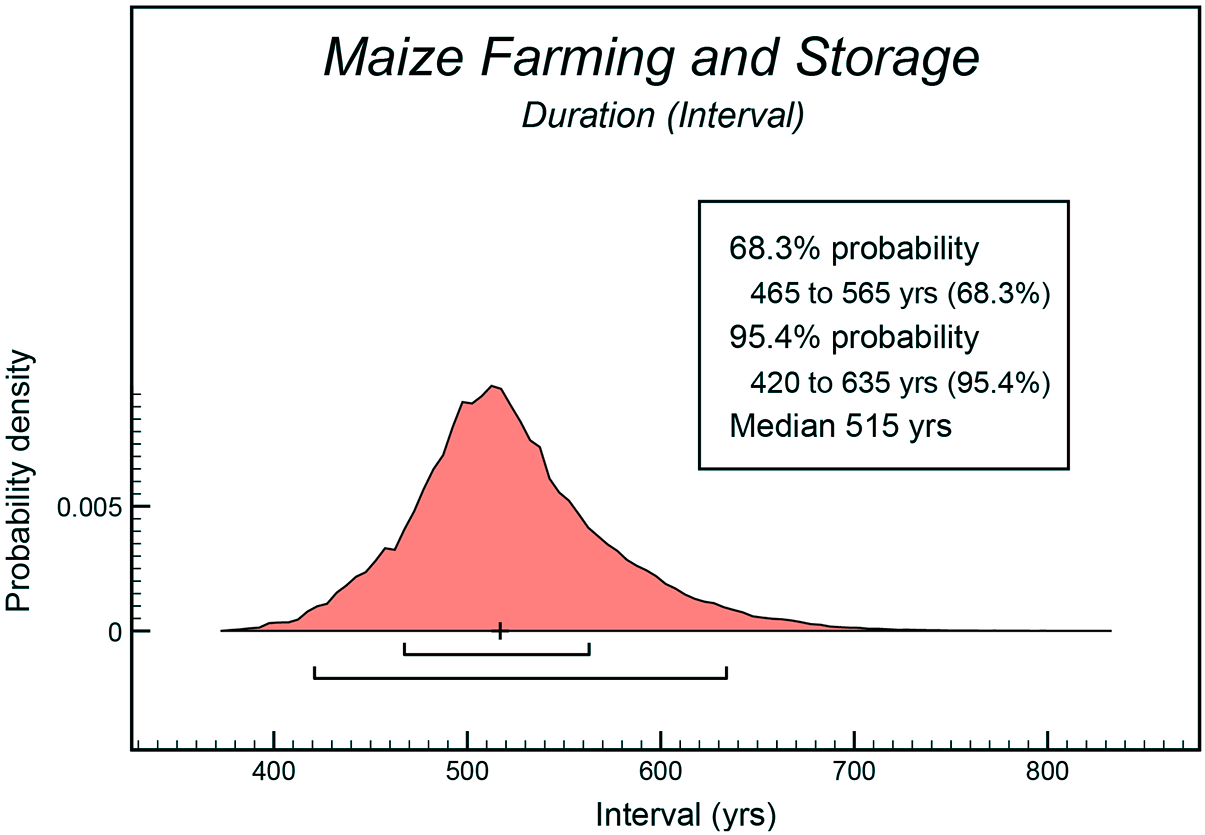
Our Bayesian model in OxCal provided posterior density estimates (hpd) for the beginning and end of Fremont maize horticulture in northwestern Colorado, rounded to the nearest five modeled yrs. Small-scale corn farming likely started cal AD 675–835 (95.4% hpd), and most probably from cal AD 740–815 (68.3% hpd). We estimate the phase ended between cal AD 1225 and 1335 (95.4% hpd) or, more likely, cal AD 1270–1320 (68.3% hpd). In addition, our model produced an hpd for the total duration of Fremont maize farming and storage: the phase most likely lasted for a period of 515 years based on the median of the entire hpd distribution, with ranges of 420–635 years (95.4% hpd) and 465–565 years (68.3% hpd; Figure 4).
Modeled duration (interval) for the Fremont corn horticulture and storage phase.

Table 2 provides a summary of the modeled boundaries in the uniform phase, including estimates for the beginning and end of maize-related deposition in site subphases. Modeled ranges for individual dates and phase boundaries can vary slightly between model runs due to stochasticity in the Markov chain simulations and rounding errors, but the differences per iteration are not substantive (ranging from 5 to 10 years on average). The Bayesian model passed with good agreement using the standard indices in OxCal (Amodel = 85, Aoverall = 82.6).
Highest Probability Density (hpd) Age Estimates for Boundary Parameters in the Uniform Bayesian Model Phase.

Notes: Modeled dates and ranges rounded to the nearest five years. See Table 1 for modeled ranges of individual radiocarbon dates.
Temporality of Corn Horticulture
The cumulative SPD of our calibrated dates deviated significantly from a simulated theoretical distribution represented by a 95% critical envelope (Figure 5a), with a global p-value of 0.004. Significant positive local deviations occurred between cal AD 970–1050 and cal AD 1090–1130, suggesting higher than expected date densities or “peaks” in our SPD centered near the first millennium AD. Significant negative local deviations were also present and spanned cal AD 650–710, cal AD 730–770, and cal AD 1200–1300. We did not formally analyze rates of change or modal differences as part of our analysis, but the data hint at relatively short, multidecadal intervals of farming intensification and decline. The positive local deviations may represent only a few generations during which eastern Fremont farmers invested heavily in maize cultivation as an economic option. A downturn took place over the next 70 years after cal AD 1130: corn became significantly underrepresented in site assemblages (cal AD 1200–1300), suggesting that eastern Fremont communities rapidly rebalanced their economic practices toward other options as cultivation became less successful or desirable over time.
Summed probability plots depicting results of hypothesis testing conducted with the rcarbon package in the R statistical environment (Crema and Bevan Reference Crema and Bevan2021): (a) cumulative observed SPD; (b) marked granary permutation test; (c) marked nongranary permutation test; (d) marked northern geographic sample permutation test; (e) marked southern geographic sample permutation test. The gray bands in each plot represent a 95% confidence envelope based on 1,000 simulated realizations of the null model. For the cumulative SPD (a), the null model represents a uniform constant probability of events over time. For the mark permutation tests (b–e), the null model represents randomly shuffled permutations of mark presence or absence over time. Temporal ranges highlighted in red indicate a positive local deviation from the null model. Temporal ranges colored blue represent negative deviations from the simulated null envelopes. (Color online)

The results of the mark permutation tests did not reveal significant sample bias regarding the presence of granary features (Figure 5b–5c). The sample of dates from sites with granaries was larger than that from sites without granaries, but the permuted SPDs did not differ significantly when compared to the 95% critical null hypothesis envelope representing random shuffle simulations of marks (p = 1). The chronology of maize storage did not show unique peaks or pauses when compared to other dated contexts with maize, suggesting that needs for storage followed the same general trends as maize consumption over time. Fremont researchers may still have preferentially sampled sites with granaries given the differences in sample size, and sites with granaries may still yield more datable corn given the nature of basket transport. However, there is a strong indication that researchers are effectively sampling both corn storage and general consumption of corn over time, given the similarities of the two marked SPDs.
We document minor differences in the geographic permutation test (Figure 5d–5e). First, a global p-value of 0.28 suggests that our observed SPDs do not differ significantly from a null hypothesis of random marks; all else being equal, dates from north or south of the White River could be drawn from the same statistical population, and there is no significant evidence for geographic bias. The test detected two local deviations in the SPDs. Dates from cal AD 650 to 750 are overrepresented south of the White River and underrepresented north of the White River, suggesting the earliest dates occur in the vicinity of Canyon Pintado, which may be the location for the earliest use of maize in the region. The date range approximates a span of time with a significantly low sample size overall, as demonstrated by results of the test comparing our cumulative SPD with a uniform theoretical null model. We believe that the local deviations are primarily a result of edge effects in the SPD analysis, rather than of geographic differences in the corn horticulture timeline. Other studies have documented similar issues with edge effects in SPD analysis (e.g., Bird et al. Reference Bird, Freeman, Robinson, Maughan, Finley, Lambert and Kelly2020; Hart Reference Hart2022; Kelly et al. Reference Kelly, Mackie, Pelton and Robinson2025; Timpson et al. Reference Timpson, Colledge, Crema, Edinborough, Kerig, Manning, Thomas and Shennan2014).
Our SPD analyses are based on low sample sizes by comparison to larger studies that examine demographic changes over time. Low sample size is thus a valid concern in the detection of significant peaks or lulls in the SPD, although there is no definitive method for determining minimum sample sizes in most cases (Crema Reference Crema2022). We argue that our SPD analysis subverts many of the well-known issues with archaeological interpretation of radiocarbon-dated contexts in very large datasets (e.g., Dates as Data, or DAD), which attempt to aggregate many different types of target events to model demography over time. Our analysis focuses solely on dates from corn macrofossils and storage features and does not make use of other types of radiocarbon dates (such as hearth charcoal or animal bone) that may complicate a clear understanding of the rise and fall of corn farming practices. Therefore, despite our sample size issues, we expect that the models described here accurately reflect eastern Fremont horticultural trends, which took place at narrow multigenerational timescales.
Discussion and Conclusion
Our modeled Bayesian chronology and SPD analysis provide additional context for interpreting previously defined trends of Fremont lifeways in northwestern Colorado and across the Uinta Basin. First, we find no evidence that corn horticulture was used during the Formative-era transition encompassing the “Early Fremont” period described by Spangler (Reference Spangler1995, Reference Spangler, Madsen and Metcalf2000) for the Uinta Basin (AD 1–550) and later adopted by Reed and Metcalf (Reference Reed and Metcalf1999:118–119) for Moffat and Rio Blanco Counties. These authors describe the Early Fremont as a preceramic phase of experimental corn horticulture, when hunting was still popular and residential mobility was relatively high. Finley and colleagues (Reference Finley, Robinson, DeRose and Hora2020) document the initial onset of maize horticulture between cal AD 100 and 380 (68.3% hpd) for the Cub Creek Uplands in the western portions of Dinosaur National Monument in Utah—a time when year-to-year precipitation was unpredictable, perhaps necessitating small-scale agriculture to supplement foraged diets (Finley et al. Reference Finley, Robinson, DeRose and Hora2020:Figure 4; Talbot and Richens Reference Talbot and Richens1996, Reference Talbot and Richens2004). We find no strong evidence of Early Fremont maize horticulture in northwestern Colorado, however, and we suggest that corn farming practices may have diffused to our study area (and perhaps other marginal areas) much later than in the core of the Uinta Basin.
The rcarbon model-fitting routine detected spikes in the cumulative SPD between cal AD 970–1050 and cal AD 1090–1130, which are consistent with Spangler’s (Reference Spangler1995, Reference Spangler, Madsen and Metcalf2000) Uinta Fremont period (AD 550–1050) and Reed and Metcalf’s (Reference Reed and Metcalf1999) Scoggin period. These researchers defined the period as a time when Fremont communities consolidated into farming hamlets and practiced intensive horticulture including the use of grayware ceramics and granary-storage features. In Cub Creek, Finley and coworkers (Reference Finley, Robinson, DeRose and Hora2020) documented intensive occupation of lowland pithouses between modeled dates of cal AD 840 and cal AD 1080 when precipitation regimes stabilized between drought intervals during the Medieval Climate Anomaly (MCA), suggesting a concerted formation of farming communities. Their dataset combines radiocarbon dates on corn macrofossils with a large sample of hearth charcoal dates (Finley et al. Reference Finley, Robinson, DeRose and Hora2020:Table 1), and although it can be difficult to parse out maize-specific chronologies from this work, it does suggest an intensification of material deposition during the MCA. Thus, our new results support evidence of a basin-wide pattern of intense farming practices during the MCA that included the easternmost fringe of Fremont activity in Colorado, despite a lack of evidence for major pithouse community formation. The popularity of maize farming may have extended into Colorado at roughly the same time as the core of the Uinta Basin, but the paucity of farming villages suggests that populations maintained a rural character.
Spangler (Reference Spangler1995, Reference Spangler, Madsen and Metcalf2000) defined the Late Fremont period for the Uinta Basin (AD 1050–1300) based on a dearth of radiocarbon dates and limited evidence of corn horticulture, suggesting a 300-year decline of the basin’s prominent farming villages. Reed and Metcalf (Reference Reed and Metcalf1999) redefined this timeframe as the Wenger period in northwestern Colorado to encompass continued evidence of farming and use of Fremont material culture. They also introduced the Texas Creek Overlook period to accommodate extremely late-dating Fremont activities persisting from AD 1300 to AD 1600.
Our modeled chronology does not extend into the Texas Creek Overlook period; the end of maize farming in northwestern Colorado mirrored the Late Fremont period throughout the Uinta Basin. Investigations at the Texas Creek Overlook site (5RB2435) identified a single maize pollen grain indirectly dated by other types of materials (Creasman and Scott Reference Creasman and Scott1987). Creasman and Scott (Reference Creasman and Scott1987) refer to late dates from 5MF373 and 5MF379 in the Skull Creek area as additional examples of the extended Late Fremont lifeway, but these dates were produced in the 1950s using solid-carbon methods lacking isotopic correction. The lack of directly dated maize or granary storage features within the hypothesized Texas Creek Overlook period calls into question previous assertions about late Fremont lifeways along the eastern fringe; additional chronological research on other aspects of the Fremont tradition (such as rock art, defensive pinnacle architecture, and open or sheltered habitation sites) is needed to further address this issue. In sum, we recommend that archaeologists in Colorado and elsewhere make a focused effort to apply updated chronologies using reliable sample types engaged with clear depositional outcomes and behavioral processes, as opposed to broadly defined phases of a hypothesized Late Fremont tradition.
Our modeled chronology of maize horticulture in northwestern Colorado presents a more restricted timeline of the quintessential Fremont farming lifeway than previously considered, a period spanning 515 years centered on the first millennium AD. We believe this is the direct result of our choice to focus on accurate radiocarbon dates with a clear context and an association with the byproducts of Fremont corn farming, including directly dated corn macrofossils and food-storage features. We exclude potentially erroneous and irrelevant dates from other types of samples and features that may be cursorily related to Fremont occupation phases or reflect nonfarming aspects of the Fremont lifeway. For further research, we suggest improving the precision of our modeled chronology by producing new radiocarbon dates on corn and granaries. Researchers should radiocarbon date additional types of materials not considered in this article, such as charred cooking residues with maize phytoliths (e.g., Hart Reference Hart2022). We also suggest comparing the chronology of directly dated animal remains and foraged plants in Fremont site contexts to better understand the balance of corn within Fremont diets over time. Lastly, we suggest that researchers perform detailed paleoenvironmental reconstructions focusing on the MCA in this easternmost fringe of the Uinta Basin. Recent chronological and paleoenvironmental models of the Range Creek and Nine Mile Canyon granary clusters on the West Tavaputs Plateau (Vernon et al. Reference Vernon, Yaworsky, McCool, Spangler, Brewer and Codding2024; Yaworsky Reference Yaworsky2021; Yaworsky et al. Reference Yaworsky, Vernon, McCool, Hart, Spangler and Codding2024) and in the Cub Creek area of Dinosaur National Park (Finley et al. Reference Finley, Robinson, DeRose and Hora2020) provide an opportunity for fine-grained spatial and temporal assessments of the risks and opportunities associated with corn farming, community aggregation, and decisions to cache cultivated crop yields. Such analyses may help us understand why pithouse communities and villages are missing from the eastern Fremont record in Colorado, despite seemingly dense arrangements of granary features in specific drainages like Canyon Pintado.
Acknowledgments
We thank our field crews for assisting in recording the granaries and collecting the maize samples discussed in this project, and we recognize the efforts of Julia Kenyon, Spencer Little, Kim Biela, and Michelle Dinkel in making this project a success. Thank you to Kathy Puseman for providing her macrobotanical expertise on our projects. We greatly appreciate the efforts of the Bureau of Land Management in supporting this work through permitting, discussion, field visits, review, and funding. Specifically, we want to thank Brian Yaquinto, Sarah MacDonald, and Lukas Trout of the White River Field Office and Dan Haas and Natalie Clark of the Colorado State Office of the Bureau of Land Management. We very much appreciate the Ute Indian Tribe of the Uintah and Ouray Reservation for granting us permission to radiocarbon date the maize as part of this project. Finally, we are grateful to Judson Finley and three anonymous reviewers for their supportive comments, constructive criticisms, and helpful suggestions for clarity.
Funding Statement
Funding for this project was provided by the James and Audrey Benedict Fund for Mountain Archaeology and the Bureau of Land Management.
Data Availability Statement
For all data and code for reproducing this analysis, see the Supplementary Materials.
Competing Interests
The authors declare none.
Supplementary Material
The supplementary material for this article can be found at https://doi.org/10.1017/aaq.2025.10161.
Supplementary Material 1. Radiocarbon dates excluded from this study (figure).
Supplementary Material 2. Bayesian model code (code).
Supplementary Material 3. Summed probability model code (code).


 Open access