


Introduction
Mesopotamia is the home of the world's first cities, and one of the largest of these urban centres, at approximately 500ha, is ancient Lagash (Tell al-Hiba, in the Dhi Qar province of south Iraq). Occupation of this site dates mainly to the Early Dynastic period (c. 2900–2334 BC). Archaeological survey data suggest that, during this period, southern Mesopotamia reached its most urbanised, with estimates that 71–82 per cent (Adams Reference Adams1981: 90) or 60–90 per cent (Marchetti et al. Reference Marchetti2019) of the population lived in cities. These urban centres commonly extended to several hundred hectares in size (Wilkinson et al. Reference Wilkinson, Ur, Hritz, Wilkinson, Gibson and Widell2013; Algaze Reference Algaze2018; Lawrence et al. Reference Lawrence, Philip and de Gruchy2021).
Early Dynastic southern Mesopotamia was divided among multiple city-states ruled by hereditary dynasties. Inter-state conflict is evidenced by monumental artistic representations of kings as military leaders. Royal inscriptions record battles, including between Lagash and its neighbour, Umma (Cooper Reference Cooper1983; Richardson Reference Richardson2012). These inscriptions also describe other royal endeavours, including the construction of city walls, temples and irrigation canals. Regional traditions in material culture suggest that conflict was paralleled by peaceful contacts and collaboration in the acquisition of luxury materials, such as lapis lazuli. This tension between conflict and collaboration, and the intensity of urbanism, make the Early Dynastic a stimulating period for research, and the predominantly Early Dynastic occupation of Lagash offers a rare opportunity to examine multiple contemporaneous aspects of a single, important Mesopotamian city. In this article, we introduce some of the results of the Lagash Archaeological Project.
There is an unresolved debate over the density of occupation within Mesopotamian cities (Wilkinson Reference Wilkinson2003; Algaze Reference Algaze2008, Reference Algaze2018; Wilkinson et al. Reference Wilkinson, Ur, Hritz, Wilkinson, Gibson and Widell2013; McMahon Reference McMahon, Heffron, Stone and Worthington2017: 374; Marchetti et al. Reference Marchetti2019). Fletcher (Reference Fletcher1995) argues for an upper limit of approximately 100ha for densely occupied agrarian settlements; according to this model, Lagash, at 500ha, could only bypass this limit with low-density occupation and open areas within the urban area. The research questions of the Lagash Archaeological Project thus begin with demographics: how large was the city's population, and did the residents live in crowded neighbourhoods or a dispersed, low-density pattern? The enormous extent of Lagash, and its proximity to two other cities—Girsu/modern Tello and Nigin/modern Tell Zurghul (Figure 1)—also raises questions of how these cities were economically sustained. For example, Lagash was close to marshes, with access to rich but often underestimated resources, including reeds, fish, birds and boar, which may have contributed to the city's viability; how did the city draw on its immediate hinterland for resources? In connection with this, where were the canals and river channels on which the settlement depended for irrigation and transportation, and how were they integrated into the urban landscape? Finally, our project examines the urban economy: did the population's demands for manufactured goods lead to intensification of specialisation and the clustering of manufacturing for production efficiency? And what craft production, if any, was organised at the household level? With these research questions, we approach Mesopotamian cities from a new, multi-scalar perspective.
Location of Lagash and other sites mentioned in text (figure © Lagash Archaeological Project).

Previous research
Tell al-Hiba is identified as ancient Lagash from an inscription found by Safar and Jacobsen in the 1950s. The first organised excavations were undertaken by Crawford and Hansen in 1968–1976 and 1990, focusing on religious and administrative buildings (Crawford Reference Crawford1974; Hansen Reference Hansen1978, Reference Hansen1992; Figure 2). These include, in Area A in the south-west part of the city, the Ibgal temple, dedicated to Inanna, goddess of love and sex; the temple is dated by inscribed foundation deposits to the reign of King Eannatum, c. 2400 BC. The Bagara temple, located in Area B in the west of the city, was dedicated to Ningirsu, warrior god and patron deity of the Lagash city-state. Inscribed objects from the Bagara temple suggest it was contemporaneous with the Ibgal temple. Area C, near the centre of Lagash, was the location of an administrative building, of the same date as the temples, dedicated to trade and redistribution. Finally, another possible temple, of Early Dynastic I date (c. 2900–2600 BC), was located in Area G in the south-west of the city. The findings of these early excavations were supplemented in 1984 by surface survey, which assessed the expansion and contraction of the city over time and identified possible production zones for pottery and metal-, stone- and shell-working (Carter Reference Carter1990).
Plan of Lagash with 1968–1990 excavations, 1984 survey units, and 2019 trenches, survey units and magnetic gradiometry survey areas (figure by E. Hammer).

Thus, at the start of our project in 2019, we began with a good knowledge of the site's monumental architecture and of the spatial distribution of materials, set within a detailed framework of third-millennium BC political history. Our research questions, outlined above, sought to develop understanding of complementary aspects of the city's archaeology through environmental sampling, drone imagery, magnetic gradiometry, surface survey and excavation.
Environmental studies
The modern Lagash floodplain slopes only 8m over the course of approximately 80km from Rifa'i in the north to al-Islah in the south, with slight depressions between current and former canal levees (Cotha Consulting Engineers 1959). Historical documents from the Islamic (AD 628/629) and Mongolian (AD 1258) invasions of Iraq detail the effects of major floods and shifting rivers, which largely established the modern Shatt al-Gharraf regime (flow, sedimentation and diversions), and which mask earlier hydrological conditions (Khidher Reference Khidher2020). Nevertheless, the region's mosaic of lakes, marshes, fields and steppe was already present in the third millennium BC; indeed, humans have engineered and exploited this complex setting for at least 7000–8000 years (Wilkinson et al. Reference Wilkinson, Rayne and Jotheri2015).
During the fifth to third millennia BC, Lagash lay within a highly active delta environment that was subject to both natural and anthropic processes. Shifting sea-levels, coastline and river courses determined the rate and form of alluvial progradation and thus the physical underpinnings of the city and its hinterland. These natural phenomena and the timing of these changes, however, remain poorly understood at the micro-regional level. Irrigation was established in southern Iraq by the sixth millennium BC at least, and increasingly arid conditions from the early fourth millennium BC onwards (Altaweel et al. Reference Altaweel2019) may have compelled the construction of larger, longer canals, which would have affected the hydrology in the city's micro-region. Together, rivers and irrigation systems had a disproportionate impact on economies of scale across Mesopotamia by increasing land fertility and enabling long-distance transport, supporting large urban populations and increased social complexity (Kennett & Kennett Reference Kennett and Kennett2006; Algaze Reference Algaze2008; Pournelle & Algaze Reference Pournelle, Algaze, McMahon and Crawford2014; Wilkinson et al. Reference Wilkinson, Rayne and Jotheri2015).
The exact courses of the Tigris River and canals near Lagash in the third millennium BC are largely unknown, although proposals have been made based on remotely sensed data (Hritz Reference Hritz, Altaweel and Hritz2021). The lack of local, high-resolution geomorphological data compels us to rely on Early Dynastic texts to extrapolate the ancient ecology of the area. These texts mention the ‘Marsh of Lagash’, which contributed fish and birds for consumption and exchange (Jacobsen Reference Jacobsen1969: 105; Prentice Reference Prentice2010). These texts also confirm that Lagash and neighbouring cities co-existed within a dense network of smaller towns and villages, with inhabitants engaged in hunting, fishing, farming and pastoralism (Carroué Reference Carroué and Bruschweiler1983: 103–109; Lecompte Reference Lecompte, Selz and Dittmann2015: 236). Storehouses, watchtowers and rural shrines dotted the landscape (Selz Reference Selz1995: 122; Rey Reference Rey2016: 40), illustrating a “fluid continuum” (Adams Reference Adams1981: 26) between city and countryside. Water was crucial to this system. By the late Early Dynastic, the major cities of the Lagash city-state were connected by a large, artificial watercourse—the id-NIGINki-DU, ‘Going-to-Nigin Canal’ (Carroué Reference Carroué1986: 14; Rost Reference Rost, Selz and Wagensonner2011)—which, at one point, extended to the Persian Gulf (Heimpel Reference Heimpel1998: 153). Additional canals linked shrines dedicated to divinities of the state pantheon (Huh Reference Huh2008), who took symbolic boat journeys within the city-state and beyond (Sauren Reference Sauren1969; Beld Reference Beld2002). The Gu'edena, a fertile and well-watered area, lay between Lagash and its rival Umma, and inscriptions describe the intergenerational struggle for its ownership and use (Cooper Reference Cooper1983; Schrakamp Reference Schrakamp and Berking2018: 125). In addition to large, state-managed watercourses, smaller canals managed by households, temporary dams and run-off basins collectively created a dissected and largely artificial landscape.
Geoarchaeological research
To characterise the environmental context of Lagash during its urban development, we extracted eight 12m-deep sediment cores by hand-auger and one 16.5m core by rotary drill, at pre-determined off-site locations (Figure 3). Our sampling strategy targeted relict features of geoarchaeological interest identified on satellite imagery, including former levees, crevasse-splays and delta lobes. We are currently conducting sedimentological, radiometric and geochemical fingerprinting studies at the Woods Hole Oceanographic Institution to identify and date past micro-environments and their physical relationship to the city.
Approximate territorial boundaries and Early Dynastic site locations based on Jacobsen's (Reference Jacobsen1969) regional survey, with auger locations (after Rey Reference Rey2016: figs. 24 & 26) (figure by R. Goodman).

Multi-disciplinary survey and remote sensing
A site as vast as Lagash requires large-scale spatial and landscape archaeology approaches to reconstruct the layout of the city. In 2019, we used three survey and remote sensing methods, based on those recently applied at Ur (Hammer Reference Hammer2019) and informed by results obtained at Uruk, Fara and other sites in southern Iraq (Fassbinder et al. Reference Fassbinder, Becker and Ess2005; Marchetti et al. Reference Marchetti2019).
Surface survey
Integrated archaeological surveys incorporate data from a range of methods but are anchored by systematic surface collections to document artefact chronology, density and the distribution of materials and activities. At Lagash we build on the earlier site survey (Figure 2; Carter Reference Carter1990). Our 2019 surface collections confirm Carter's conclusion that most of the pottery dates to the late Early Dynastic (Early Dynastic III, c. 2500–2334 BC). With this main period of habitation confirmed, we have sought to use the distribution of ceramics and other materials to map industrial, residential and administrative activity areas.
The survey units of 10 × 10m were spaced 50m or 100m apart, depending on the specific objective for collection in each area (e.g. broad area coverage to expand on the earlier survey versus higher-resolution context for our excavation trench in Area H). We used a Trimble R1 GPS with Viewpoint RTX correction service and ESRI's Collector for ArcGIS mobile application to navigate to pre-determined locations. Surveyors traversed each 10 × 10m unit in five transects spaced 2m apart, collecting all diagnostic ceramics (rims, bases, handles and decorated body sherds) and any non-ceramic artefacts. Surveyors also recorded the total number of sherds and fragments of ceramic production waste. Where artefact density was particularly high (approximately 2000+/10m2), totals were calculated based on a sample count along one transect multiplied by five. All diagnostic sherds were counted, weighed and recorded by type and date.
In 2019, we covered survey units south of Area C that were inaccessible in 1984 due to recent flooding related to the greater extent of the adjacent marshes in the 1980s. The water of these former marshes was slow-moving and had deposited sediment, but erosion and artefact displacement appear to have been minimal and our survey recorded a dense spread of artefacts. We also carried out a higher-resolution surface collection in Area H, around our excavation trench, establishing the extent of pottery and ceramic waste concentrations in the southern part of the city (Figure 4A & B). The distributions of non-ceramic artefacts indicate multiple areas possibly associated with the production of metal objects and stone tools (Figure 4C & D). This pattern confirms and extends the evidence for the economic multi-centrism suggested by Carter's earlier survey work.
A) Ceramic counts for the 122 survey units in 2019; B) ceramic slag concentrations surrounding Area H; C) concentrations of metal finds; D) concentrations of chert and flint (figure by E. Hammer).

UAV photogrammetry
In regions with mudbrick architecture and soil salinisation, such as southern Iraq, under the right conditions, UAV (or drone) photography is a powerful tool for mapping buried, near-surface architecture. Following rainstorms, walls, streets and room fills absorb or shed water and cause the precipitation of salts at different rates. The resulting contrasts in soil moisture and salinity may reveal archaeological features. In 2019, we captured more than 31 000 photographs from an altitude of approximately 80m, with a DJI Phantom 4 drone, using Drone Deploy for flight planning and Agisoft Metashape for photogrammetric processing.
Given Lagash's large size and flat topography, it was plausible that the site was characterised by low-density activity; we can now conclude that this was not the case. The UAV photography reveals a very high density of architecture across hundreds of hectares. Most areas of the city are densely filled with architectural remains; the survey, and excavations (of 2019 and 2022), indicate that these features are probably of Early Dynastic III date (Figure 5). Based on an estimate of 100–200 persons per hectare commonly used for other ancient Near Eastern cities (Wilkinson et al. Reference Wilkinson, Ur, Hritz, Wilkinson, Gibson and Widell2013), the later third-millennium BC city may have housed 60 000–120 000 inhabitants. Such a large potential urban population underscores the necessity for a robust, yet flexible, economic base. The UAV imagery is currently being processed as the basis for a full spatial analysis of walls, streets and other urban features. Here, we highlight two notable discoveries: monumental walls surrounding large areas of ‘organic’, or unplanned, occupation in the southern part of the site (see below), and highly regular and densely occupied residential areas in the northern part of the city. These distinctive areas may present slightly different phases of urban growth or, alternatively, quarters set aside for specific groups, perhaps determined by origin, profession or identity.
Example of UAV photography results showing dense architecture; north at top (figure by E. Hammer).

Magnetometry
Geophysical methods have proved effective for mapping subsurface architecture at Mesopotamian sites (Fassbinder et al. Reference Fassbinder, Becker and Ess2005; Hahn et al. Reference Hahn2022). Our long-term plan is to achieve site-wide geophysical coverage. In 2019, we started by surveying four test areas, totalling approximately 14ha, using a fluxgate magnetic gradiometer (Bartington Grad 601-2; Figure 2). Data were collected in 20 × 20m grid squares with 0.5m transect separation and processed for noise reduction and image optimisation using Archaeofusion software (Ernenwein et al. Reference Ernenwein, Hargrave, Cothren and Avery2014).
The results from south of the Area H excavation reveal a particularly clear section of a city wall, approximately 10m wide, with 6 × 6m buttresses placed every 20m (Figure 6). A gate with towers provided access to a main street running north-west into the site. Inscriptions of the Early Dynastic III period describe city wall construction as one of the main royal building activities; King Ur-Nanshe (c. 2500–2450 BC) specifically claims to have built the wall of Lagash (Cooper Reference Cooper1983: 44). City walls are ostensibly defensive, and their documentation thus supports textual descriptions of inter-city conflict during the Early Dynastic III. As corporate monumental architecture, however, city walls also served as ideological tools to reinforce concepts of citizenship; their high visibility and permanence within a shifting landscape of marshes, gardens and fields may have advertised the stability of the city and the power of its kings.
Magnetic gradiometry results showing the buttressed city wall and towered gate at the site's southern edge (figure by E. Hammer).

Excavations
Area G
Our excavations in Area G, in the south-west of the site, aimed to examine the monumental architecture of Lagash at an early stage in the city's development. Previous excavations had exposed two architectural features: a curving enclosure wall to the east and a complex of rooms housing administrative activities to the west (Hansen Reference Hansen and Edzard1980–1983, Reference Hansen1990; Ashby & Pittman Reference Ashby, Pittman, Nadali, Pittman and Polcaro2022). Work in 2019 explored the area between these features, in order to clarify the nature and phasing of activities carried out in the building.
A 4 × 20m trench was positioned over a previously unexcavated section of the enclosure wall. We identified two building phases (Figure 7). Phase II corresponds to the Early Dynastic I (c. 2900–2600 BC) initial construction and use of the wall (Hansen's Level 2A; Hansen Reference Hansen1990). Four trampled ashy surfaces (‘floors’) are associated with this phase. The earliest sloped down from the wall at 10cm/m over a distance of 3m. Later floors had a steeper slope near the wall face but levelled out rapidly and then sloped gradually upward, before disappearing at the surface at the western end of the trench. The irregularity of these floors and lack of architectural features suggests that the space between the wall and western complex was an open courtyard used for work and/or outdoor rituals. Multiple ‘T-drains’—a specialised cylindrical ceramic form with two spouts at the base (Renette Reference Renette2021)—were recovered in this area.
A) Plan of Area G; B) drone image of Area G; C) N section of 2019 trench (figure © Lagash Archaeological Project).

The later Phase I is represented by a poorly preserved rebuilding of the enclosure wall, identifiable primarily by traces of a layer of reeds laid within the wall. Reeds were commonly used elsewhere in Area G and at other contemporaneous sites (e.g. Nippur; McMahon Reference McMahon2006: 9, 21 & 25) to separate building phases and prevent the uneven settling of superimposed structures. Post-dating these two phases, we also identified intrusive features from eroded levels of Early Dynastic III date (c. 2500–2334 BC). These consist of pits filled with pottery, ash and faunal remains, as well as two human graves, which contained one adult and one infant, interred in flexed positions; there were no intact grave goods. Intramural burial was common in the Early Dynastic, and these graves were presumably buried below a now-eroded structure.
Area H
Area H is located at the southern end of the site, where slag, ash and wasters noted in the 1984 survey cover the surface. This area was selected for excavation to examine the intensity of pottery production and the nature of any workshops. A particularly dense area of ash and slag was selected as the focus for a 10 × 10m trench. Five kilns were identified. The oval firepits were the only preserved parts, the domed upper structures having been completely eroded. All are orientated consistently, north-east to south-west (Figure 8). From the stratigraphy, four are approximately contemporaneous, and two are partially superimposed, suggesting dedicated and intensive use of this space. The kilns were dug into earlier heaps of finely stratified sloping ash more than 1m in depth, indicating that the area was the focus of sustained pottery production activities over some time. The recovery of thousands of carbonised date pits from deposits of material raked out from the kilns suggests that these seeds were a major source of fuel. The only architectural features identified consisted of small mudbrick walls, which probably served as windbreaks or storage features. Based on the associated pottery, the kilns date to early Early Dynastic III.
Area H, showing overlap of kiln 2 (later) and kiln 5 (earlier) (figure © Lagash Archaeological Project).

Material culture
The objects recovered during the survey and excavations are typical of third-millennium BC southern Mesopotamian sites and demonstrate the existence of trade networks with the Zagros Mountains and Oman, bringing stone and copper, respectively, to the city. Thirty-two fragments of stone vessels were recovered: 11 from Area G, four from Area H and 17 from the surface survey. These are primarily of banded calcite. A few copper/bronze fragments were recovered during survey, and a total of 29 lithics were collected from the survey and excavations, comprising mostly flint blades or scrapers, along with three heavily reduced cores.
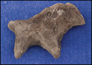
Within the combined survey and excavation assemblage, tools made of clay are almost as common as stone tools, including eight fragments of fired-clay sickles, multiple ceramic discs and net weights, three ring scrapers and several spindle whorls. These objects reflect the diversity of the city's economic base: farming, fishing, and ceramic and textile production. Nine fired-clay animal figurines were found in or near the kilns in Area H—all quadrupeds of unidentifiable species (Figure 9A). Comparable figurines are known from Abu Salabikh (McAdam Reference McAdam and Green1993) and previous excavations at Lagash (Bahrani Reference Bahrani1989). A clay cone foundation deposit with an inscription of King Enmetena, a successor of Eannatum, was collected during the surface survey (Figure 9B).
A) Animal figurine from Area H; B) inscribed foundation deposit of King Enmetena; C) seal impression with figurative design; D) seal impression with geometric motif; E & F) seal impression with possible ‘city seal’ design. Scales in cm (figure © Lagash Archaeological Project).

Area H yielded 59 fragments of clay with sealing impressions. Most of these fragments (39) were recovered from ash fill in the northern kiln; the remainder came from adjacent ash layers. Recognisable among these objects are six door sealings, three bag sealings, three jar neck sealings and one jar stopper, reflecting a range of sealing practices, including the management of storage and the movement of goods and raw materials. The sealing designs find their best parallels in late Early Dynastic I, as represented by the Seal Impression Strata at Ur (Legrain Reference Legrain1936). They are also comparable to sealings previously recovered in the western complex of Area G. Patterns include figural imagery (Figure 9C), geometric patterns (Figure 9D) and one impression of the ‘city-seal’ variety (Matthews Reference Matthews1993) (Figure 9E & F). The early date of these impressions suggests that they were redeposited from earlier levels, perhaps during construction of the kiln fire pits.
Ceramics
The Area G excavations yielded typical Early Dynastic I pottery. Conical beakers and bowls (Figure 10, nos 1 & 2) represent over two-thirds of the assemblage, totalling hundreds of examples. These mass-produced vessels, used for individual eating and drinking, are the most widespread form throughout southern Mesopotamia in the third millennium BC. We also recovered solid-footed goblets—a chronological marker of early Early Dynastic I (Figure 10, no. 3). These mass-produced vessels are similarly widely attested in central and southern Mesopotamia and associated with the communal consumption of beverages, probably beer (Benati Reference Benati and D'Andrea2019: 66). These beakers and bowls suggest that the open courtyard within the building was used for ritual feasts. Among the closed shapes there is a high percentage of low-necked jars (Figure 10, no. 4), which may have been used as cooking pots (Renette Reference Renette2021), as well as spouted jars for liquid storage and serving (Figure 10, no. 5). Flat-bottomed serving trays (Figure 10, no. 6) were also recovered. Phase I yielded a number of late Early Dynastic I or early Early Dynastic IIIA vessels. In this phase, large deep bowls (Figure 10, nos 7 & 8) and fenestrated stands are attested, perhaps reflecting a shift in emphasis from individual to communal consumption.
Ceramics from Area G (1–8) and Area H (10–12). Scales in cm (figure © Lagash Archaeological Project).

The pottery from Area G also includes a Scarlet Ware jar sherd with painted decoration featuring quadrupeds and vegetation. Scarlet Ware was produced mainly in central Mesopotamia and in the Diyala Valley to the north-east of Baghdad (Del Bravo Reference Del Bravo and de Miroschedji2014); the presence of this ware at Lagash suggests that extended trade links via the Tigris River existed early in the city's history.
The pottery assemblage from Area H dates to Early Dynastic IIIA. Conical bowls, represented by thousands of sherds and complete vessels, make up approximately 75 per cent of the assemblage; many have warped shapes and overfired fabric, suggesting that they were wasters from the kilns. In comparison with Early Dynastic I examples, they are shallower, with a wider rim diameter, following regional trends (Gruber Reference Gruber, Dittmann and Selz2015) (Figure 10, no. 9). Large, deep bowls (Figure 10, no. 10) and a variety of jars were retrieved, including hole-mouth jars (Figure 10, no. 11) that were probably used as cooking pots (Renette Reference Renette2021) and necked jars for liquid storage (Figure 10, no. 12). The variety of ceramic forms suggests that the workshops responded to a range of demands.
The pottery from the survey mostly belongs to the Early Dynastic III (97 per cent), confirming the site's principal period of occupation. The Early Dynastic III pottery assemblage matches that from the Area H excavations and mainly consists of open forms, with conical beakers and bowls being the most common, plus a wide range of jars. Sporadic late third- to early second-millennium BC sherds were also recovered.
Discussion
The first results of our excavations and survey work at Lagash provide insight into questions about urban population density and the zoning of activities within the city. In Area G, for example, changes between Phases II and I may reflect the alteration, relocation or abandonment of a major public building, suggesting a restructuring of this part of the city during its period of maximum growth. The survey and remote-sensing data confirm that the city was densely occupied, and demand for space for housing may have compelled some urban restructuring.
The Area H excavations allow us to begin to address questions about the intensity of craft production and to reconstruct the resources that sustained the city's population. Activities on the edge of the fourth-millennium BC city of Tell Brak, north-east Syria, comprised a mix of industrial production, rubbish dumping and human burial (McMahon & Stone Reference McMahon and Stone2013), reflecting a flexible approach to the use of early urban space. Our project examines whether such flexibility was also characteristic of a later southern Mesopotamian city, or whether the demands of a larger population and strong traditions of property ownership in an established city led to more permanent industrial quarters and more rigid urban zoning. The superimposed kilns and deep ash layers in Area H suggest intensive production in dedicated workshops. The high density of kiln waste there covers an area of approximately 75 × 150m; if there were four roughly contemporaneous kilns per 10 × 10m across this entire area, this would amount to 500 kilns. This number seems unlikely, however, as it is probable that kilns were arranged in groups, each associated with an open space for raw materials storage and the discard of kiln waste. The number of kilns in this wider area, however, may easily have reached 100 in such an arrangement. The intensity of this production and its efficiency of organisation, bringing together labour and the large-scale acquisition and storage of raw materials, maps well onto the dense population suggested in the UAV imagery and magnetometry results.
Most studies of urban resource demands and supplies focus on food and materials such as metals or stone; access to fuel, however, is crucial to a city's sustainability. In the arid Mesopotamian alluvial plains, the acquisition of fuel would have been an important concern, both for manufacturing and domestic purposes. The supply of wood was limited, and existing timber, such as acacia and poplar that grew near rivers and canals, was in demand for the construction of boats, furniture, roofing and other purposes (Willcox Reference Willcox1992). Oak is occasionally evidenced by phytoliths for the fifth millennium BC but was no longer present by the third millennium BC (Altaweel et al. Reference Altaweel2019); palm trees were only used as fuel when no longer productive. Animal manure and dried reeds were common alternative fuel sources (Miller Reference Miller1984). The use of date pits for kiln fuel in Area H is comparable to the occasional use of olive pomace (the material remaining after olive oil pressing) as fuel in the Levant from the third millennium BC, and more commonly around the Mediterranean in the Roman era (Rowan Reference Rowan2015). Strabo (Geography 16.1.14; Falconer & Hamilton Reference Falconer and Hamilton1889) records the use of date pits for fuel by Hellenistic bronze workers in Babylonia; date pits converted to charcoal were also used by silversmiths in early twentieth-century Iraq (Dowson Reference Dowson1921: 60). The use of date pits for fuel at mid-third millennium BC Lagash is one of the earliest examples of this practice, emphasising the deep history of traditional crafting activities. As date pit fuel has not yet been reported from other southern Mesopotamian sites, Lagash adds to our evidence for the diversity of resources exploited across the region.
Conclusion
The Lagash Archaeological Project has initiated a multi-scalar approach to one of the largest of the early cities of Mesopotamia, addressing the organisation of the urban landscape and the integral role of the surrounding micro-region. New remotely sensed data demonstrate dense urban occupation, occasionally relieved by areas dedicated to industrial production, public buildings and streets. Large walls defined parts of the city perimeter and possibly bounded some neighbourhoods within it. The site's extraordinary scale and occupational density were enabled by intensive production and by the availability of a mosaic of resources from the gardens, marshes and riverbanks surrounding the city. By looking beyond palaces and monumental buildings and focusing on the organisation of space and acquisition of resources at Lagash, our results demonstrate the importance of bottom-up approaches to early Mesopotamian cities and their hinterlands.
Acknowledgements
We thank the former and current Ministers of Culture, Tourism and Antiquity, Dr Abdulamir al-Hamdani and Dr Hassan Nazim; the former and current Directors General of the State Board of Antiquities and Heritage, Dr Qais Rashid and Dr Laith Majid Hussein; and the Inspectorate of Dhi Qar, Tahir al-Hosseini. Thanks also go to Ahmed Khadem, Haider Schneiwer and Saad Ali of the State Board of Antiquities and Heritage, Iraq; Dr Liviu Giosan (Woods Hole Oceanographic Institution); and Eijkelkamp North America.
Funding statement
Funding was provided by the British Institute for the Study of Iraq; Louis J. Kolb Society of Fellows, Penn Museum; Metropolitan Museum of Art; National Geographic Society (#386R-18); Reckitt Trust; and University of Pennsylvania.


 Open access