Introduction
During recent times the vast North African region has contributed exciting discoveries and a dramatic improvement of knowledge on – to name just a few – the early stages of human evolution, the emergence of our species or the early manifestation of symbolic behavior (e.g. d’Errico et al. Reference d'Errico, Vanhaeren, Barton, Bouzouggar, Mienis, Richter, Hublin, McPherron and Lozouet2009; Gallotti et al. Reference Gallotti, Muttoni, Lefèvre, Degeai, Geraads, Zerboni, Andrieu-Ponel, Maron, Perini, El Graoui, Sanz-Laliberté, Daujeard, Fernandes, Rué, Magoga, Mohib and Raynal2021; Hublin et al. Reference Hublin, Ben-Ncer, Bailey, Freidline, Neubauer, Skinner, Bergmann, Le Cabec, Benazzi, Harvati and Gunz2017; Richter et al. Reference Richter, Grün, Joannes-Boyau, Steele, Amani, Rué, Fernandes, Raynal, Geraads, Ben-Ncer, Hublin and McPherron2017; Sahnouni et al. Reference Sahnouni, Parés, Duval, Cáceres, Harichane, van der Made, Pérez-González, Abdessadok, Kandi, Derradji, Medig, Boulaghraif and Semaw2018), which have significantly enhanced the role of north Africa in understanding major evolutionary dynamics of the human lineage.
Despite the interest of different international research groups especially focused on a number of North African areas of intense research distributed mainly along the Atlantic and Mediterranean belts and the Nile river, much remains unknown about Pleistocene contexts in the Sahara, which covers almost a third of the continent and is certainly among the privileged places for investigating human migration, adaptation and survival in recurrently extreme environments.
Together with difficult accessibility of some areas and the particularly demanding efforts to sustain archaeological fieldwork in the most remote areas, cyclical sociopolitical instability suffered especially in recent years by several regions can also be advocated for the rarity of intensive geoarchaeological missions. Nevertheless, Saharan research ‘hot spots’ do exist, and have provided crucial information on Pleistocene human occupation of large areas and regions. Among these are the Jebel Gharbi, located close to the very northernmost edge of the Sahara, in Libya (Barich et al. Reference Barich, Garcea, Giraudi, Mutri and Lucarini2010; Garcea and Giraudi Reference Garcea and Giraudi2006; Spinapolice and Garcea Reference Spinapolice and Garcea2014); the oases of Dakhla, Kharga (Hawkins Reference Hawkins, Hublin and McPherron2012; Kleindienst Reference Kleindienst, Marlow and Mills1998), Bir Tarfawi, Bir Sahara (Nicoll Reference Nicoll2018; Wendorf et al. Reference Wendorf, Schild and Close1993), Farafra (Barich et al. Reference Barich, Lucarini, Hamdan and Hassan2014; Mutri Reference Mutri, Bagnall, Davoli and Hope2013) in Egypt’ Western Desert; the Acacus and Messak in south-western Libya (here discussed); Adrar Bous in Northern Niger (Clark and Gifford-Gonzalez Reference Clark and Gifford-Gonzalez2008).
The increasingly awareness of the late Middle Pleistocene and late Pleistocene paleoenvironmental variations recorded in North Africa suggests that the region played an essential role in wide-scale processes of cultural and biological evolution by triggering and driving dispersals and shaping demography (e.g. Coulthard et al. Reference Coulthard, Ramirez, Barton, Rogerson and Brücher2013; Drake and Breeze Reference Drake, Breeze, Jones and Stewart2016; Drake et al. Reference Drake, Breeze and Parker2013; Ehrmann and Schmiedl Reference Ehrmann and Schmiedl2021; Larrasoaña Reference Larrasoaña, Hublin and McPherron2012; Larrasoaña et al. Reference Larrasoaña, Roberts and Rohling2013; Nicoll Reference Nicoll2018; Pausata et al. Reference Pausata, Gaetani, Messori, Berg, Maia de Souza, Sage and deMenocal2020; Quade et al. Reference Quade, Dente, Armon, Ben Dor, Morin, Adam and Enzel2018; Scerri et al. Reference Scerri, Drake, Jennings and Groucutt2014; Tierney et al. Reference Tierney, deMenocal and Zander2017). However, the scarceness of archaeological, chronometric and paleoanthropological data, also due to severe preservation constrains, prevents development of reliable models about the relations that linked the different bio-geographic regions north and south of the Sahara at the time of crucial transitions and turnovers, as for example the emergence of our own species, thus leaving the overall picture very fragmented.
Further, the weak chronological control we still have upon the large majority of Stone Age archeological contexts in the Sahara implies that we are trapped within de-contextualized and circular arguments connecting archaeological evidence with paleoenvironmental conditions, inevitably and automatically linking the presence of artefacts with wet phases and diffuse availability of water sources. If on one side this equation is not here questioned, it is anyhow suggested that the exclusion a priori of humans’ relations with challenging environments can be misleading. Coping with difficult or unknown ecological settings could in fact have been a major driver for behavioral adjustment, large scale displacement, increased interactions between populations and diffusion of technological innovations.
According to this perspective, it is here proposed a review of the archaeological record of mostly Middle and late Pleistocene age from the Sahara of SW Libya, with an emphasis on the Middle Stone Age, in an attempt at framing the puzzling and still incomplete evidence from this part of North Africa into a narrative at the very least plausible.
The main data source upon which this review builds was assembled through the research, surveys and excavations carried out between 1990 and 2011 by the Italian-Libyan archaeological mission in the Acacus and Messak, one of the most long-lived geo-archaeological missions in this part of the Sahara. Here, the mission had proficiently worked for more than half a century (e.g. Cremaschi and di Lernia Reference Cremaschi and di Lernia1998b; di Lernia Reference di Lernia1999b; di Lernia and Manzi Reference di Lernia and Manzi2002; di Lernia and Zampetti Reference di Lernia and Zampetti2008; Garcea Reference Garcea2001c; Liverani Reference Liverani2005; Mori Reference Mori1965, Reference Mori2013), until the dramatic outcomes of the 2011 revolution and the post-revolutionary processes made the country definitively inaccessible to foreigners, and its heritage at risk (di Lernia Reference di Lernia2015; di Lernia and Gallinaro Reference di Lernia, Gallinaro and Castillo2014). Although not in a systematic way, the data are appropriately complemented by results of the geoarchaeological research activity conducted by the research teams of the Desert Migration Project-Paleo (2007–2011) led by Marta Mirazón Lahr and Robert Foley who has been intensively investigating part of the same general area (Mattingly Reference Mattingly2019; Mirazón Lahr et al. Reference Mirazón Lahr, Foley, Armitage, Barton, Crivellaro, Drake, Hounslow, Maher, Mattingly, Salem, Stock and White2008, Reference Mirazón Lahr, Foley, Crivellaro, Okumura, Maher, Davies, Veldhuis, Wilshaw and Mattingly2009, Reference Mirazón Lahr, Foley, Crivellaro, Maillo Fernandez, Wilshaw, Purdon, Halladay-Garrett, Veldhuis and Mattingly2010, Reference Mirazón Lahr, Foley, Crivellaro, Fernandez, Wilshaw, Copsey, Rivera and Mattingly2011).
The region witnessed alternated population dynamics driven by fluctuating water availability in the alternation of glacial/interglacial periods which likely triggered diverse behavioral tuning of the human species who left the huge amounts of lithic artefacts scattered nearly everywhere in the region and are a sign of protracted human occupation. The paleoenvironmental setting of the study region is thus first presented with an overview of the main landforms and the geological proxies upon which Pleistocene environments and climate are reconstructed. The evolution of the human occupation is then proposed following the classic tripartite subdivision of the African Stone Age, not only because of the special attention that this article would like to focus on cultural elements, but also because the artefactual evidence represents the most commonly available basis on which to build a coarse chrono-cultural framework of population dynamics. In many cases, and with the evident risk of circular reasoning, the artefactual evidence is also the only source of information used to assign some chronological boundaries to the geological evidence.
Like other areas in the wider Saharan region, the central Saharan massifs are characterized by a deeply eroded landscape where Plio-Pleistocene geo-archaeological archives are extremely rare, preventing thus the construction of long chrono-cultural sequences from multiproxy stratified deposits. Exceptions do exist, like the caves and rock-shelters inside the Acacus mountains. Thanks to the preservation conditions and the studies conducted there, they still represent key reference sequences of, for example, the Aterian occupation (Cremaschi et al. Reference Cremaschi, di Lernia and Garcea1998) and the far better preserved Holocene archaeology (Barich Reference Barich1987; Cremaschi and di Lernia Reference Cremaschi and di Lernia1998b; Cremaschi et al. Reference Cremaschi, Zerboni, Mercuri, Olmi, Biagetti and di Lernia2014; di Lernia Reference di Lernia1999b; Garcea Reference Garcea2001c).
Apart from these cave deposits and a few other preserved sequences (such as dunes, lacustrine and soils), Pleistocene sites mostly consist of lithic scatters of variable size, complexity and spatial definability, whose archaeological content was mostly defined on the spot on the basis of recognizable diagnostic artefacts (Anag and di Lernia Reference Anag, di Lernia, Anag, Cosentino and Di Lernia2007; Biagetti et al. Reference Biagetti, Cancellieri, Cremaschi, Gauthier, Gauthier, Zerboni and Gallinaro2013; Cremaschi and di Lernia Reference Cremaschi, di Lernia, Cremaschi and di Lernia1998a). The ‘life-times’ of different technologies can overlap or are separated by large gaps, and the chrono-cultural phases inferred from them may span long periods of time, so that the classification of most part of the archaeological record is only definable in terms of broad attributions, and the resulting picture is inevitably coarse-grained.
Moreover, especially in the deflated stone pavements of the mountains, artefacts are usually intermixed with residual surfaces, hindering the recognition of discrete clusters and phases of occupation. From a methodological viewpoint, thus, one of the issues to be addressed in this kind of environments is the very definition of ‘site’ (e.g. Foley Reference Foley1981; Olszewski et al. Reference Olszewski, Dibble, McPherron, Schurmans, Chiotti and Smith2010). If the clustering of stone artefacts in the sand dunes are often discrete entities, this is not the case of the residual stone pavements such as the hamada of the Messak or the structural terraces of the Acacus. Here, the progressive dismantling of sedimentary units by wind erosion generated stony surfaces where artefacts related to different occupations separated by thousands of years lye on the same surface. Even if the preservation of some spatial configuration could be in some cases recognized, the rule is a palimpsest of artefacts without well-defined boundaries. In some areas of the Messak plateau, for example, the density and continuity of artefacts distribution, resulting from complex depositionary histories (Knight and Zerboni Reference Knight and Zerboni2018) is as high (Foley and Mirazón Lahr Reference Foley and Mirazón Lahr2015) as the sole methodological approach is to arbitrarily split the surface record on a statistical basis, e.g. predefined sample areas. This type of approach is not new to African archaeology, especially in those areas that present similar challenges, such as the Egyptian high desert (Olszewski et al. Reference Olszewski, Dibble, Schurmans, McPherron and Smith2005).
A research strategy based on a large territorial scale of fieldwork has been able to intercept different and diverse topographical and morphological contexts to relate to inferable macro-dynamics of land use, lines of human penetration and dispersals. Even if hampered by the scarceness of stratified contexts and of datable materials, it provided elements useful at least for perceiving the complexity of Pleistocene human dynamics in this part of the central Sahara.
The study area
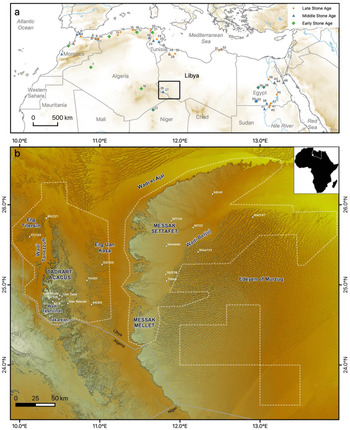
The study area is located in the south west of the Fezzan region, in Libya, near the border with Algeria and Niger (Figure 1a). It is approximately framed between 24°–26° N and 10°–13° E. It consists of a range of diversified physiographic features, comprising mountains, sand seas and large fluvial plains (Figures 1b and 2). Most of its geomorphological features are fossil and they originated in warm pluvial phases of the Tertiary, the Pleistocene interglacials, and the Early Holocene (Perego et al. Reference Perego, Zerboni and Cremaschi2011; Zerboni et al. Reference Zerboni, Perego and Cremaschi2015).

Figure 1. (a) Localization of the research area (rectangle) in the wider North African context. Major Stone Age sites are also identified (after Barham and Mitchell Reference Barham and Mitchell2008; Barton et al. Reference Barton, Bouzouggar, Hogue, Lee, Collcutt and Ditchfield2013; Bouzouggar and Barton Reference Bouzouggar, Barton, Hublin and McPherron2012; Cancellieri and di Lernia Reference Cancellieri and di Lernia2013; Garcea Reference Garcea2010, Reference Garcea, Hublin and McPherron2012; Hawkins Reference Hawkins, Hublin and McPherron2012; Ramos et al. Reference Ramos, Bernal, Domínguez-Bella, Calado, Ruiz, Gil, Clemente, Durán, Vijande and Chamorro2008; Roset Reference Roset2005; Van Peer Reference Van Peer, Jones and Stewart2016): 1, Jebel Irhoud; 2, Casablanca sequence; 3, Contrebandiers, Dar es-Soltan; 4, Mugharet el Aliya; 5, Benzù; 6, Kehf el Hammar; 7, Tabelbala; 8, Ifri n Ammar; 9, Taforalt; 10, Rhafas; 11, La Mouillah; 12, Tighenif; 13, Columnata; 14, Rassel; 15, Afalou Bou Rhummel; 16, Tamar Hat; 17, Aïn Hanech; 18, Tihodaine; 19, Bir el Ater; 20, Ouchtata; 21, Sidi Zin; 22, Adrar Bous; 23, El Guettar; 24, Horizon Collignon; 25, Wadi Akarit; 26, Uan Tabu; 27, Uan Afuda; 28, Shakshuk; 29, Ras el Wadi; 30, Wadi Ghan; 31, Hagfet ed Dabba; 32, Haua Fteah; 33, Bir Sahara; 34, Bir Tarfawi; 35, Dakhla; 36, Kharga; 37, Sai 8-B-11; 38, Arkin; 39, Nazlet Kather 4; 40, Wadi Halfa; 41, Jebel Sahaba; 42, Ballana; 43, Taramsa; 44, Shuwicat; 45, Wadi Kubbaniya; 46, Sodmein Cave; b: Main geographic features of the research area and localization of sites and areas discussed in the text; dashed lines indicate the extent of the territorial researches carried out so far.
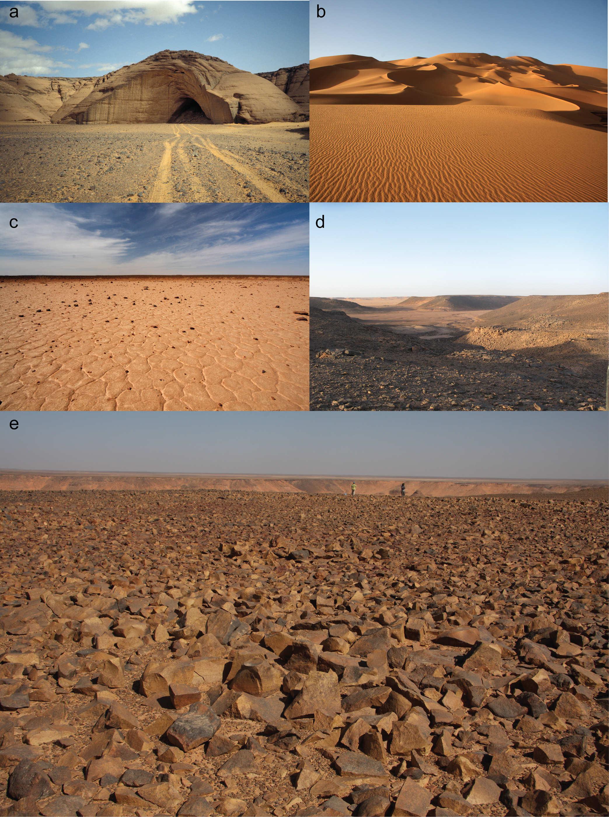
Figure 2. Some examples of diverse environmental settings of the study region: the Uan Afuda cave in the Tadrart Acacus (a); a dune-field along the Wadi Tanezzuft (b); the surface of an endorheic depression (c); net of large wadis and tributaries (d); and the typical hamada stone pavement in the Messak (e) (© the Archaeological Mission in the Sahara, Sapienza University of Rome).
The Acacus and Messak are elongated massifs delimited by abrupt scarps to the West and North-West, respectively. The Acacus is characterized by an articulated fossil drainage network and represents the only area with diffuse presence of caves and rock-shelters (Figure 2a) famous for their Holocene rock art and archaeology (Cremaschi and di Lernia Reference Cremaschi, di Lernia, Cremaschi and di Lernia1998a, Reference Cremaschi and di Lernia1999b; di Lernia and Zampetti Reference di Lernia and Zampetti2008; Gallinaro Reference Gallinaro2013, Reference Gallinaro and Smith2014; Mori Reference Mori1965). The Messak (Figures 2c–e) is a cuesta-type relief incised by a complex net of fossil river valleys (Zerboni et al. Reference Zerboni, Trombino and Cremaschi2011). It is formed by two main massifs, the Messak Mellet, to the south, and the Messak Settafet, to the north. The landscape is dominated by a vast stone pavement covered in rock varnish. The main physiographic units are residual surfaces (hamada and serir) punctuated by river valleys and endorheic depressions (Knight and Zerboni Reference Knight and Zerboni2018; Perego et al. Reference Perego, Zerboni and Cremaschi2011).
Most of the lowlands surrounding the mountains are covered by the dune-fields of the Erg Titersin, to the north west of the study area, the Erg Uan Kasa, between the Acacus and the Messak, the Edeyen of Murzuq to the south-east and the Edeyen Ubari to the north. The lowlands also include some large wadi systems: the Wadi Tanezzuft, west of the Acacus; the Wadi El-Ajal and the Wadi Berjuj respectively north and south of the Messak (Figure 1b).
Systematic territorial research in the region started with the surveys and excavations of the joint Italian-Libyan Archaeological Mission in the early 1990s (Cremaschi and di Lernia Reference Cremaschi, di Lernia, Cremaschi and di Lernia1998a). Although with different degrees of resolution, ca. 17% of the entire study area has been surveyed. As far as the Pleistocene record is concerned, around 1600 contexts have been identified so far. The very large majority is made of surface scatters, but stratified assemblages from intensively investigated cave sites are available as well (di Lernia Reference di Lernia1999b; Garcea Reference Garcea2001c).
In the field, extensive and intensive survey (Cremaschi and di Lernia Reference Cremaschi and di Lernia1999b) have been generally applied, the first aimed at evaluating the geo-archaeological potential over very large areas, while the second was carried out on foot. The sampling principles were defined by spatial criteria, whether arbitrary or natural. Examples are the adoption of survey strips within one out of three basins in the Edeyen of Murzuq (Anag and di Lernia, Reference Anag, di Lernia, Anag, Cosentino and Di Lernia2007) or within 4 x 2 kilometre transects in the Messak (Biagetti et al. Reference Biagetti, Cancellieri, Cremaschi, Gauthier, Gauthier, Zerboni and Gallinaro2013; Gallinaro et al., Reference Gallinaro, Gauthier, Gauthier, Le Quellec, Abdel Aziz, Biagetti, Boitani, Cancellieri, Cavorsi, Massamba N'Siala, Monaco, Vanzetti, Zerboni and di Lernia2012). In the latter case, the field documentation of a square area of 10 x 10 metres every 100 metres along selected strips was also added because of very high artefact density.
The Acacus mountain was exclusively investigated by intensive surveys. Here, the survey mostly targeted the rock shelters, where the presence of Pleistocene deposits, usually hidden by the most widespread Holocene fillings, can only be revealed by deep soundings. The surveys in the Acacus also focused on the open-air contexts located on the structural surfaces of the massif, as well as along the valleys bottom and the margins of the main wadis.
The Messak plateau is characterized by a hamada stony surface (Figure 2e) poorly accessible by car for its roughness. Nevertheless, both intensive and extensive surveys have been performed. Other than for pursuing specific research objectives (e.g. Cremaschi and di Lernia Reference Cremaschi and di Lernia1998b; Cremaschi et al. Reference Cremaschi, di Lernia and Garcea1998), intensive surveys were carried out as an assessment of the cultural and environmental heritage in a series of areas selected for prospection and exploitation by the oil industry, and were carried out by car and on foot by large teams investigating series of predefined transects (Anag et al. Reference Anag, Cremaschi, di Lernia and Liverani2002; Biagetti et al. Reference Biagetti, Cancellieri, Cremaschi, Gauthier, Gauthier, Zerboni and Gallinaro2013; Gallinaro et al. Reference Gallinaro, Gauthier, Gauthier, Le Quellec, Abdel Aziz, Biagetti, Boitani, Cancellieri, Cavorsi, Massamba N'Siala, Monaco, Vanzetti, Zerboni and di Lernia2012).
The sand seas of the Erg Uan Kasa and the Erg Titersin, where there is good accessibility and excellent archaeological visibility, enable rather remunerative surveys and have been extensively surveyed. The Edeyen of Murzuq, the largest sand sea in the region, has been subject to both extensive and intensive surveys (Anag and di Lernia Reference Anag, di Lernia, Anag, Cosentino and Di Lernia2007; Cremaschi and Zerboni Reference Cremaschi, Zerboni, Martini and Chesworth2011).
The rare, discontinuous and poorly preserved geological markers of Pleistocene morphogenesis that formed during wet and dry conditions include weathered paleosurfaces, paleosols, slope deposits, weathered dunes, fluvial and lacustrine deposits.
A reconstruction of the Pleistocene paleoenvironmental evolution of the Acacus and Messak was synthetized by M. Cremaschi and A. Zerboni (in Cancellieri et al. Reference Cancellieri, Cremaschi, Zerboni, di Lernia, Jones and Stewart2016). Humid conditions triggered soil weathering and led to the formation of thick pedological cover (Zerboni et al. Reference Zerboni, Trombino and Cremaschi2011), dismantled during subsequent arid periods by wind erosion. In the Messak, a pedogenic carbonatic concretion from a ferralitic paleosol in the Wadi Berjuj was U/Th dated to roughly MIS 7, indicating the existence of paleosols in the late Middle Pleistocene (Cremaschi Reference Cremaschi, Cremaschi and di Lernia1998; Zerboni et al. Reference Zerboni, Trombino and Cremaschi2011). The paleosols on the plateau, discontinuously preserved, are covered by weathered aeolian sand related to a Middle Pleistocene desert ingression, as exemplified i.e. by site MT114, where Acheulean artefacts were found between the paleosol and the weathered aeolian sand. Gravel megabars along the valleys of the Messak often include rolled Acheulean and Middle Stone Age artefacts (Perego et al. Reference Perego, Zerboni and Cremaschi2011), like i.e. at site MT22 along the Wadi Mathendush (Cremaschi and di Lernia Reference Cremaschi, di Lernia, Cremaschi and di Lernia1998a).
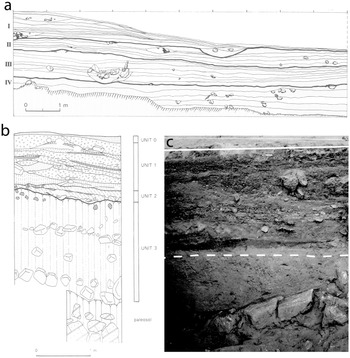
In the central Tadrart Acacus, the sites of Uan Tabu and Uan Afuda (Figure 3) register a human occupation of the area during MIS 4 (Cremaschi et al. Reference Cremaschi, di Lernia and Garcea1998). The two metres thick sandy sequence of the Uan Afuda cave includes two levels of fallen blocks, and a reddish paleosol on the top. TL dating of the sand above the upper blocks, whose base included the MSA artefacts, gave 70 ± 9.5 ka and 73.5 ± 10 ka, in quite good agreement with OSL determinations from the same layer, which returned 69 ± 7 ka. Sand above the lower level of blocks gave a further OSL date of 90 ± 10 ka (Cremaschi et al. Reference Cremaschi, di Lernia and Garcea1998; Martini et al. Reference Martini, Sibilia, Zelaschi, Troja, Forzese, Caputa, Gueli, Cro, Foti, Pellegriti, Cremaschi and di Lernia1998), and is related to the beginning of dune aggradation inside the cave. At Uan Tabu rock shelter the Pleistocene aeolian sand is less developed than at Uan Afuda, but it includes a larger amount of Aterian artefacts (Garcea Reference Garcea2001c). It was OSL dated to 61 ± 10 ka (Cremaschi et al. Reference Cremaschi, di Lernia and Garcea1998; Martini et al. Reference Martini, Sibilia, Zelaschi, Troja, Forzese, Caputa, Gueli, Cro, Foti, Pellegriti, Cremaschi and di Lernia1998). Remnants of rubified aeolian dunes associated with MSA artefacts were also found at other locations in the Acacus, i.e. in the Wadi Teshuinat and the Wadi Takarkori.

Figure 3. Stratigraphic sections at Uan Tabu (a) and Uan Afuda (b). Note in c the change at the transition between the Pleistocene and early Holocene parts of the Uan Afuda sequence indicated by a dashed line (a and b, modified after Cremaschi et al. (Reference Cremaschi, di Lernia and Garcea1998); c, modified after Cremaschi and di Lernia (Reference Cremaschi, di Lernia and di Lernia1999a)).
A U/Th date for a caliche crust at the top of a Pleistocene lacustrine deposit in the Erg Uan Kasa (TH 101) gave 68.7 + 4.4–4.2 ka (Cancellieri et al. Reference Cancellieri, Cremaschi, Zerboni, di Lernia, Jones and Stewart2016). These data can be related to a semi-arid environment where high evapotranspiration caused the formation of the caliche after the lacustrine deposit sedimentation. The sand ingression at Uan Afuda and Uan Tabu, in the Acacus mountain, would instead indicate arid conditions at approximately the same time interval. The different physiographic contexts in the Acacus compared to the Erg Uan Kasa may be advocated to explain the different environmental signatures.
Examples of Pleistocene archaeological contexts related to aeolian dunes outside the mountain environments are rare. This is the case i.e. of the late Acheulean site 94/84 (not dated), in the Erg Uan Kasa, where the stratigraphic context is partially preserved and it consists of a notable concentration of hand-axes, cleavers and Levallois artefacts, in part exposed on the surface and in part found in situ within a fossil dune (Cremaschi and di Lernia Reference Cremaschi, di Lernia, Cremaschi and di Lernia1998a).
Most of the Pleistocene geo-archaeological evidence in the sand seas consist of lacustrine marls and caliche, and of outcrops of deeply weathered paleosols and fluvial deposits. A faunal assemblage possibly associated with ‘Mode 1’ lithics, including turtles and large mammals, was discovered in the Erg Uan Kasa in an eroded outcrop of lacustrine sediments covered by a caliche crust at site 03/105, while at site M4a/11a, in the Edeyen of Murzuq, faunal remains of mainly small ungulates of unknown age, associated to MSA artefacts, were identified underneath fluvial deposits and at the top of a rubified soil cemented in an iron oxide crust. No direct dating is available, but the site is likely to be related to a wet stage in MIS 5 (Cancellieri et al. Reference Cancellieri, Cremaschi, Zerboni, di Lernia, Jones and Stewart2016).
The most well preserved lacustrine deposits were observed in the north-western edge of the Edeyen of Murzuq, forming the upper terraces located in the interdune corridors (Zerboni et al. Reference Zerboni, Trombino and Cremaschi2011) and where, at least in one case (Site M4/147), an Acheulean hand-axe showing rather fresh edges was found in a terrace of lacustrine deposit at the very northernmost fringe of the Edeyen (Figure 1b). Scatters of Acheulean lithic assemblages were also discovered within large lacustrine deposits at the NW fringe of the Erg Titersin. Bleached hydromorphic sand and small gravel (serir) along the interdune corridors, interpreted as deeply eroded paleosurfaces, equally host several concentrations of Acheulean artefacts. In some cases, artefacts are associated with fragments of elephant teeth (Cancellieri et al. Reference Cancellieri, Cremaschi, Zerboni, di Lernia, Jones and Stewart2016).
Archaeological contexts
Early stone age
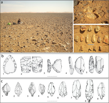
Oldowan occupation is hinted at by a very small number of surface sites with roughly shaped artefacts like core-tools on pebbles (Figure 5a) and, in some cases, flakes detached by hard hammer direct percussion found in close proximity to core-tools and showing a similar degree of weathering.
Although Oldowan-like material (i.e. Mode 1) can be designated on the basis of technological traits only, ‘simple’ technology itself does not stand for an early age. Moreover, while the earliest known technologies – i.e. the 3.3 Ma old Lomekwian (Harmand et al. Reference Harmand, Lewis, Feibel, Lepre, Prat, Lenoble, Boes, Quinn, Brenet, Arroyo, Taylor, Clement, Daver, Brugal, Leakey, Mortlock, Wright, Lokorodi, Kirwa, Kent and Roche2015) – are rather simple and rely on some basic principles of stone fracturing, it is equally ascertained that complex patterns of raw-material management and reduction are present in the technological history from at least 2.5 Ma (e.g. Braun et al. Reference Braun, Aldeias, Archer, Arrowsmith, Baraki, Campisano, Deino, DiMaggio, Dupont-Nivet, Engda, Feary, Garello, Kerfelew, McPherron, Patterson, Reeves, Thompson and Reed2019; Delagnes and Roche Reference Delagnes and Roche2005; De Lumley Reference De Lumley2006).
A very conservative and reductive attribution to the Oldowan was thus retained when artefacts made with simple ‘Mode 1’ technologies were found together with supposedly younger artefacts fitting both of the following two conditions: a clearly different technology, supposedly later in age (i.e. hand-axes or Levallois) and a less weathered physical aspect. This simple principle is helpful and applicable especially in areas of very high artefacts density, like the Messak plateau, from which most of the Oldowan occurrences come.
Only nine sites including Oldowan-like materials – among the thousand Stone Age contexts of the entire study area – have been recorded as Oldowan (Figure 4a), for which an early Pleistocene chronological attribution is only speculative. Eight contexts of this kind have been located on the Messak (Biagetti et al. Reference Biagetti, Cancellieri, Cremaschi, Gauthier, Gauthier, Zerboni and Gallinaro2013). One, in the Erg Uan Kasa, also released faunal remains, but their association with the lithic artefacts cannot be firmly established (Cancellieri et al. Reference Cancellieri, Cremaschi, Zerboni, di Lernia, Jones and Stewart2016). Other chopper-like-based assemblages extensively reported and documented from northern Messak Settafet, the Ubari Sand Sea and the Wadi Shati (Mirazón Lahr Reference Mirazón Lahr, Fleagle, Shea, Grine, Baden and Leakey2010) further support the likelihood of an Oldowan hominin occupation in the research area.

Figure 4. Distribution of Stone Age sites throughout the study area distinguished according to major technological features. Key to symbols: a: assemblages with chopper-cores; b: assemblages with large cutting tools (LCTs), e.g. bifaces and cleavers; c: assemblages with LCTs and predetermined core technology, e.g. Levallois; d : assemblages with predetermined core technology and tools on small flakes, e.g. points, scrapers, denticulates; e : assemblages with stemmed tools; f : assemblages with blade artefacts.
Acheulean contexts are very well attested and spread over much of the region (Figure 4a). They occur in a wide array of depositional contexts testifying to rather different environmental conditions for the Acheulean occupation.
Large concentrations of Acheulean artefacts have been identified in the lowlands (Erg Titersin, Erg Uan Kasa, Edeyen of Murzuq). The contexts are characterized by dozens of large shaped tools (bifaces, cleavers), tools on flakes and by-products (Anag and di Lernia Reference Anag, di Lernia, Anag, Cosentino and Di Lernia2007; Cremaschi and di Lernia Reference Cremaschi, di Lernia, Cremaschi and di Lernia1998a). The recurrent association of these contexts with lacustrine deposits suggests that Acheulean environmental and archaeological evidence spans wet phases during which lakes and lake sedimentation were widespread, suggesting the reliance on extractive activities within interglacial productive wet environments.
An Acheulean occupation was also identified associated with weathered fossil dunes. This is the case of site 94/84, in the Erg Uan Kasa (already mentioned in § ‘The study area’). Given high chronological and palaeonvironmental uncertainty, whether this can be indicative of Acheulean hominins successfully occupying desert areas during arid phases of the late Middle Pleistocene or, conversely, occupying lakeshore dune environments, is hard to state. Nevertheless, it further speaks for a widespread occupation of diverse lowland settings adding to the complex picture of late Acheulean hominins’ occupation of the central Sahara.
The mountains attest to the occurrence of Acheulean contexts as well. In the Acacus, a few isolated artefacts have been recovered into shelters, whereas larger assemblages were mostly located in open-air contexts along the valleys, on fossil dunes and structural surfaces of the massif (Cremaschi and di Lernia Reference Cremaschi, di Lernia, Cremaschi and di Lernia1998a; Cremaschi et al. Reference Cremaschi, di Lernia and Garcea1998). In the Messak, the hundreds of Acheulean contexts are especially found on the surface of the residual stone pavement that characterizes the plateau of the massif (Biagetti et al. Reference Biagetti, Cancellieri, Cremaschi, Gauthier, Gauthier, Zerboni and Gallinaro2013; Cremaschi and di Lernia Reference Cremaschi, di Lernia, Cremaschi and di Lernia1998a; Gallinaro et al. Reference Gallinaro, Gauthier, Gauthier, Le Quellec, Abdel Aziz, Biagetti, Boitani, Cancellieri, Cavorsi, Massamba N'Siala, Monaco, Vanzetti, Zerboni and di Lernia2012). When these are found stratified, they are generally included in fluvial gravel bars as redeposited materials (Cremaschi and di Lernia Reference Cremaschi, di Lernia, Cremaschi and di Lernia1998a; Cremaschi et al. Reference Cremaschi, di Lernia and Garcea1998).
Acheulean assemblages include different techno-typological elements. Bifaces are the most common large shaped tools encountered (Figure 5b). Cleavers are rarer and seem to be more frequently found in the lowlands. An array of flaking methods (Discoid, Kombewa and Levallois) have been identified, used for both the production of flake tools as well as in the production of flake supports for large shaped tools. Some technological and dimensional features, like e.g. ‘giant’ cores and predetermined flake blanks (Figure 5c) recognized at different locales of the study area (see also Mirazón Lahr et al. Reference Mirazón Lahr, Foley, Crivellaro, Maillo Fernandez, Wilshaw, Purdon, Halladay-Garrett, Veldhuis and Mattingly2010) can be ascribed to an Acheulean ‘Large Flake Component’ (Sharon Reference Sharon2007, Reference Sharon2010). These clues of large-flake technologies, adopted in the Saharan Acheulean to produce large cleaver blanks (Clark Reference Clark, Corruccini and Ciochon1994; Sahnouni et al. Reference Sahnouni, Semaw, Rogers, Mitchell and Lane2013), are thought to predate the Levallois method (Li et al. Reference Li, Kuman, Lotter, Leader and Gibbon2017; Rolland Reference Rolland, Dibble and Bar-Yosef1995; Sharon Reference Sharon2010) and are also assumed to have disappeared from the Levant and North Africa before 0.5 Ma (Sharon Reference Sharon2007, Reference Sharon2010).

Figure 5. Early Stone Age artefacts: (a) chopper-cores; (b) bifacial large shaped tools; (c) examples of ‘Large Flake’ technologies (all from Messak © the Archaeological Mission in the Sahara, Sapienza University of Rome).
The potentially very long duration of this stage in North Africa, recently and securely pushed back to at least 1.3 Ma by Gallotti et al. (Reference Gallotti, Muttoni, Lefèvre, Degeai, Geraads, Zerboni, Andrieu-Ponel, Maron, Perini, El Graoui, Sanz-Laliberté, Daujeard, Fernandes, Rué, Magoga, Mohib and Raynal2021), and the lack of solid chronological data from the study area prevent definition of an evolutionary sequence for the Acheulean occupation. Thick and deeply weathered hand-axes made on blocks or cobbles with sinuous profiles and likely fashioned by hard hammer direct percussion could point to an early Acheulean, as already suggested by Mirazón Lahr et al. (Reference Mirazón Lahr, Foley, Crivellaro, Fernandez, Wilshaw, Copsey, Rivera and Mattingly2011). Nevertheless, Later Acheulean contexts are seemingly more visible and represented, broadly identifiable by flat symmetrical bifaces, likely fashioned by soft hammer percussion signaled by flat and invasive detachments (though flaking technique is seldom identifiable because of strong weathering), and a diffuse use of the Levallois method for the production of small flakes.
Levallois technology is a shared technological trait of later Acheulean and MSA technocomplexes. For this, the surface sites including Levallois artefacts is not generally and unilaterally assignable to one or the other major groups grossly distinguished in the field by the presence/absence of hand-axes. In any cases, differences have been detected in the application of the method by establishing a comparison between the incidence of Levallois core variants in contexts with and without large shaped tools, which indicates that preferential and centripetal Levallois cores show repeated co-occurrences with hand-axes, whereas uni-bidirectional recurrent Levallois far less (Cancellieri and di Lernia Reference Cancellieri and di Lernia2013). This observation is partly consistent with data from later Acheulean contexts in diverse parts of the continent. The later Acheulean at Cap Chatelier and Sidi Abderrhamane-Extension, in the Casablanca sequence in Morocco, indicate for example an extensive use of the Levallois method, especially the lineal mode, for the production of flake tools from at least 0.35 ma (e.g. Raynal et al. Reference Raynal, Gallotti, Mohib, Fernandes, Lefèvre, Wojtczak, Wegmüller, Elsuede and Al Najjar2017). Later Acheulean contexts from NW Sahara (e.g. Mourre Reference Mourre2003), as well as in East Africa (e.g. Tryon et al. Reference Tryon, McBrearty and Texier2006) and South Africa (e.g. Wilkins et al. Reference Wilkins, Pollarolo and Kuman2010) equally show that the adoption of lineal modes of Levallois reduction is more frequently adopted respect to recurrent modes (e.g. parallel uni- and bidirectional).
Middle stone age
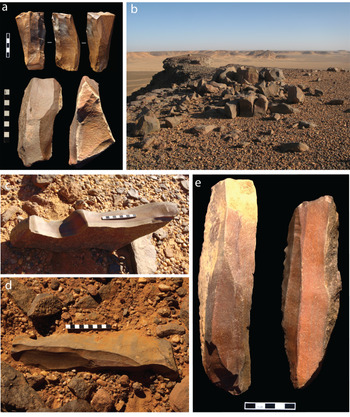
Hints at an early MSA occupation comes from site 10/578, in the southern Messak (Cancellieri and di Lernia Reference Cancellieri and di Lernia2013), an open-air surface site located in proximity of a high quality fine-grained quartzarenite outcrop (Figure 6a). The assemblage is rather homogeneous, all artefacts share the same degree of weathering and show the same varnish. It consists of a series of Levallois cores (one of the Nubian Type, Figure 6b 1), Levallois flakes, blades, large backed pieces (Figure 6b 3–5) and one fragment of a large foliate piece (Figure 6b 2), suggesting some affinities with the Lupemban industry (Barham Reference Barham2000; Barham and Mitchell Reference Barham and Mitchell2008) of the south-central African sites of Twin Rivers and Kalambo Falls, in Zambia (Barham Reference Barham2000; Clark Reference Clark2001; Duller et al. Reference Duller, Tooth, Barham and Tsukamoto2015), which is bracketed at Twin Rivers between 240 and 170 ka (Barham Reference Barham2000). Dated assemblages attributed to the Lupemban in North Africa are known from Sai 8-B-11, in Sudan, where these are overlain by sands dated at 152 ± 10 ka (Van Peer Reference Van Peer, Jones and Stewart2016; Van Peer et al. Reference Van Peer, Fullagar, Stokes, Bailey, Moeyersons, Steenhoudt, Geerts, Vanderbeken, De Dapper and Geus2003) and from Taramsa-1, in Egypt, dated to 165.5 ± 17.8 ka (Van Peer et al. Reference Van Peer, Vermeersch and Paulissen2010; Vermeersch Reference Vermeersch, Leplongeon, Goder-Goldberger and Pleurdeau2020). Based on a purely techno-typological inference, site 10/578 with Lupemban-like features in the Messak is thus tentatively assigned to the late Middle Pleistocene.
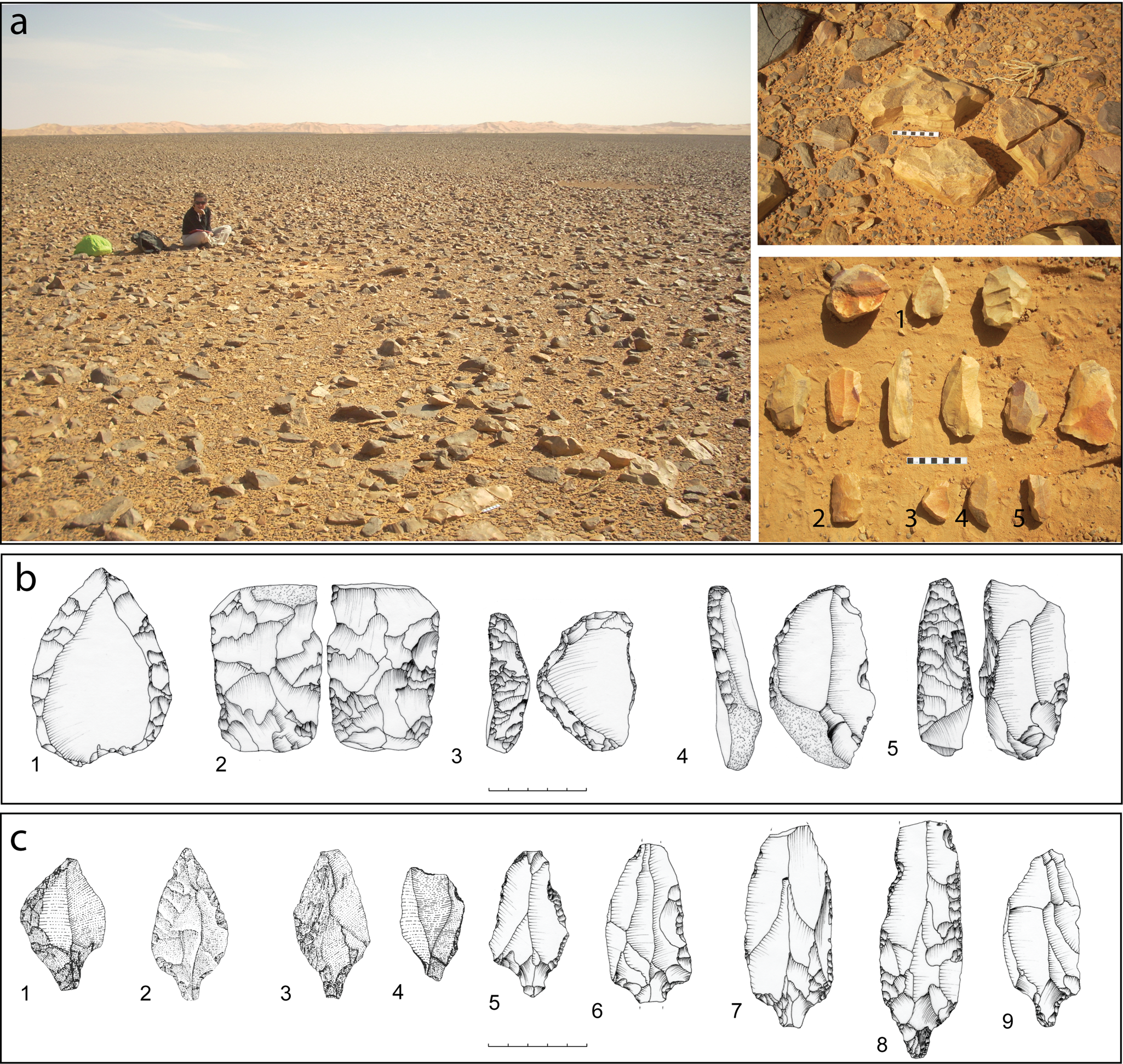
Figure 6. (a) left, view of site 10/578 in the southern Messak, the westernmost dune belt of the Edeyen of Murzuq is visible in the background; top right, raw block of quartzarenite; bottom right, collection of artefacts from the site including cores, blanks and retouched tools (numbers correspond to specimens illustrated in (b); (b) site 10/578: 1, Nubian Levallois core; 2, foliate fragment; 3–4, curved backed pieces; 5, straight backed piece (modified after Cancellieri and di Lernia Reference Cancellieri and di Lernia2013); (c) 1–4, Aterian tanged tools from Uan Tabu, Tadrart Acacus (modified after Garcea Reference Garcea and Garcea2001) and 5–9 from various surfaces sites in the Messak (modified after Cancellieri and di Lernia Reference Cancellieri and di Lernia2013) (© the Archaeological Mission in the Sahara, Sapienza University of Rome).
Most of the sites forming the MSA record are mainly from surface contexts and include barley diagnostic elements like Levallois artefacts and tools as scrapers, notches and denticulates. Elsewhere (Cancellieri and di Lernia Reference Cancellieri and di Lernia2013) we have referred to these contexts as ‘generalized MSA’, and are quantitatively better represented in the mountains than in the lowlands (Figure 4b). In the Acacus these are found in both shelters and open-air sites (on alluvia and terraces). Two shelters on structural surfaces have been identified, as e.g. site TH 126, on the 1st terrace along Wadi Teshuinat, filled by a red fossil dune containing some Levallois and discoid cores and flakes (Cremaschi and di Lernia Reference Cremaschi, di Lernia, Cremaschi and di Lernia1998a). The Messak plateau provided the great majority of the ‘generalized’ MSA record. Here, surface sites feature concentrations of artefacts where the large majority is represented by workshops. Many of these also show a good spatial preservation: refitting between flakes or between flakes and cores is common. The workshops are often located close (or on) large outcrops of quartzarenite. More than half of the identified contexts show nearly complete reduction sequences, whereas approximately one third lacks retouched blanks. The sites not classified as workshops (approximately 10%) are characterized by the exclusive presence of retouched tools, sometimes associated with unretouched Levallois flakes. Scrapers, notches and denticulates are frequently made on Levallois blanks, while Levallois point production is very barely represented, and accomplished adopting both ‘standard’ and Nubian modes.
The Aterian represents the only dated occurrence of an MSA occupation in the study area. Framed at the sites of Uan Tabu and Uan Afuda between ca. 60–70 ka, The Aterian outside the Acacus is still a regional undated record. Aterian sites are found through almost all the physiographic elements albeit with diverse densities and representation (Figure 4b). In the Erg Titersin there is a single Aterian site (01/134), which is partly covered by lacustrine sediments. The Wadi Tanezzuft area returned a handful of artefacts including tanged points at site 96/221, whereas the Erg Uan Kasa provided a slightly richer record of contexts, which are largely represented by isolated artefacts or rather ephemeral contexts. In the Edeyen of Murzuq very few contexts show a little more than an ephemeral occupation, whereas the bulk of the findings are isolated artefacts (Cancellieri et al. Reference Cancellieri, Cremaschi, Zerboni, di Lernia, Jones and Stewart2016; Cremaschi et al. Reference Cremaschi, di Lernia and Garcea1998). Assigning an MIS 4 chronology to the Aterian of the entire study area on the basis of the dates from the Acacus is not convincing, in particular when the ergs are included. Here, the presence of Aterian contexts is rather significant, but it is very likely that during MIS 4 these lowlands must have mostly resembled the extreme environments of today. For this reason, it is presumable that the Aterian evidence from the lowlands could result from earlier occupations, probably occurred during wetter environmental conditions of MIS 5. Aterian sites in the lowlands are in fact mainly located along the margins of the interdune basins, far more rarely on their very bottom, which further supports the hypothesis that the sandy lowlands were more likely occupied during phases in which lakes and ponds were present.
In the Tadrart Acacus, the Aterian occupation occurs in caves and shelters, but also in open-air contexts. The archaeological sites on the wadi floor are mainly shelters or caves, while open-air ones are almost all on higher structural surfaces. This topographic distinction is thought to be also functional, with the former interpreted as residential sites and the latter as specialized locations (Cremaschi et al. Reference Cremaschi, di Lernia and Garcea1998). Site AT 8, an open-air site located on a saddle of one of the highest structural surfaces of the Acacus, could represented an example for the latter. The lithic artefacts, which include flakes, cores and tanged tools, show a well-preserved spatial configuration, and an interpretation as a hunting-related station has been advanced (Cremaschi et al. Reference Cremaschi, di Lernia and Garcea1998; Cremaschi and di Lernia Reference Cremaschi, di Lernia, Cremaschi and di Lernia1998a).
The Aterian assemblage of Uan Tabu testifies to almost complete reduction sequences on diverse raw-materials, and it is presumed to having been formed as a result of residential occupations (Cremaschi et al. Reference Cremaschi, di Lernia and Garcea1998; Garcea Reference Garcea2001c). The tools include Levallois flakes and points, side-scrapers and tanged tools (Figure 6c 1–4). Together with Levallois and non-Levallois flaking methods, the use of the Nubian Levallois is here also attested, subtending common traits between Saharan (Aterian) and Nile valley (Nubian Complex) late Pleistocene MSA (Garcea Reference Garcea and Garcea2001b; Van Peer Reference Van Peer and Garcea2001). At Uan Afuda, a more limited lithic assemblage is conversely thought to result from brief occupation events. It lacks firmly Aterian traits. Nevertheless, the chrono-stratigraphic setting, very similar to that of the nearby Uan Tabu, allows including it in the framework of the Aterian occupation of the Acacus (di Lernia Reference di Lernia and di Lernia1999a).
Aterian sites in the Messak are mostly located on the deflated surface of the plateau. Yet, stratified sequences exist as well: at site MT 22, along Wadi Mathendush, a gravel including reworked and rolled Acheulean artefacts was superposed by a cluster of fresh Aterian artefacts (but ‘Late Paleolithic’ traits have been instead noted there by Garcea Reference Garcea and Garcea2001b) buried by Late Pleistocene aeolian sand (Cremaschi Reference Cremaschi, Cremaschi and di Lernia1998). At Wadi Tidwa, Aterian artefacts were found in a stratigraphic context between Acheulean and Pastoral flakes, in a test pit dug in a small endorheic depression. Most of the artefacts were lying in vertical position, suggesting they were displaced by hydraulic action (Garcea, Reference Garcea1996).
Possibly Aterian artefacts were collected and excavated also at Wadi Imrawen, and a sequence of Pastoral and Aterian assemblages was also identified at Wadi Adroh (Cremaschi et al. Reference Cremaschi, di Lernia and Garcea1998).
Further substantial information comes from stratified MSA-Aterian contexts identified in the northern Messak Settafet (Foley et al. Reference Foley, Maíllo-Fernández and Mirazón Lahr2013; Mirazón Lahr et al. Reference Mirazón Lahr, Foley, Crivellaro, Okumura, Maher, Davies, Veldhuis, Wilshaw and Mattingly2009, Reference Mirazón Lahr, Foley, Crivellaro, Maillo Fernandez, Wilshaw, Purdon, Halladay-Garrett, Veldhuis and Mattingly2010), where the recognizable diversified set of technological features (including use of Nubian Levallois technology, blade debitage, façonnage of large bifacial tools) is further evidence for the complexity of MSA technological package(s) of the central Sahara and of its deep rooting into late Middle Pleistocene MSA African repertoire.
Late pleistocene late stone age (?)
No firm evidence yet exists about the human presence in the region during the Late Pleistocene Late Stone Age. The environmental conditions, especially around the Last Glacial Maximum, would have prevented a stable occupation because of extremely harsh environments.
In this framework, that of the Aterian is therefore considered the last ascertained archaeological evidence in the Pleistocene. A single exception to this picture may be represented by the Messak massif, where sites including artefacts made using a non-Levallois laminar technology (Figure 7) are supposedly Late Pleistocene in age (Biagetti et al. Reference Biagetti, Cancellieri, Cremaschi, Gauthier, Gauthier, Zerboni and Gallinaro2013; Cancellieri et al. Reference Cancellieri, Cremaschi, Zerboni, di Lernia, Jones and Stewart2016). These kinds of contexts are found spread over almost all the massif (Figure 4c), but are largely concentrated on the plateau. They are mostly workshops and suggest occupation events mainly aimed at procuring and processing the local quartzarenite, which is the most used raw material. The presence of sites including tools like retouched blades, truncations and end-scrapers also indicates the existence of other types of activities, but the absence of armatures would exclude hunting.

Figure 7. (a) blade cores; (b) quartzarenite outcrop; (c) large opening elongated flake from a tabular block of fine grained quartzarenite; (d–e) large blades (© the Archaeological Mission in the Sahara, Sapienza University of Rome).
The range of techno-typological features recorded in the field revealed: a mostly non-microlithic character; the use of the crest technique; a volumetric concept of production; frontal, semi-tournante and tournante modalities of laminar reduction; a fully laminar maintenance of core convexities (bipolar reduction, neo-crests, flank extractions); the use of large blades and flakes as core blanks, testifying to ramified reduction sequences; laminar blanks with polygonal sections due to serial laminar extraction; possibly the use of soft organic-hammer percussion, mostly signaled by the observation of flaking angles.
A group of sites, mainly in central Messak Settafet, includes very large blades (up to 40 cm in length: Figure 7d and e). These are the outcome of serial laminar reductions, as was also noted e.g. by Reynolds (Reference Reynolds and Mattingly2007) on similar occurrences in the Messak. Their production is clearly linked to the raw material they are mostly made on, which are flat slabs (Figure 7c) of fine-grained quartzarenite with natural geometric features (i.e. presence of regular ridges) allowing a good control over the laminar reduction and demanding little or no effort in the shaping out of the raw blocks. Large size, a recognizable territorial clustering in the central Messak Settafet, the recurrent use of raw materials with similar morphology and a usually low surface weathering suggest that these mega-blades workshops can be considered a rather homogeneous phenomenon.
Other ‘Late Palaeolithic’ assemblages in the Messak (Figure 1b) have been identified at Tidwa-surface and Imrawen 1A, Imrawen 1B and Imrawen 2A based on either technological (e.g., crest technique, laminar reduction and special butt preparation) or a few typological traits. The chronological position is conjecturally Late Pleistocene (Garcea Reference Garcea and Garcea2001a; Van Peer Reference Van Peer and Garcea2001).
Well-developed laminar assemblages of early Holocene age are known through the whole region, except in the Messak. These are related to the first Epipaleolithic groups (Early Acacus) that repopulated the region after wetter conditions were fully re-established in the Early Holocene (Cancellieri and di Lernia Reference Cancellieri and di Lernia2014; Cremaschi and di Lernia Reference Cremaschi and di Lernia1999b). While these industries could offer a natural comparison for the laminar assemblages of the Messak, it should be observed that the production is mostly bladelet oriented, and the toolkits encompass abundant backed armatures (i.e., straight-backed bladelets and points, which have never been found in the Messak). An exception to the regional mostly bladelet-based Early Acacus industries can be represented by the ‘macrolithic’ component of the Early Acacus assemblage at Uan Afuda, where a blade component has been also recognized (di Lernia Reference Cremaschi, di Lernia and di Lernia1999a).
Links with Saharan contexts can be attempted with the Epipaleolithic of Greboun and Adrar Bous, in Niger, where a blade component related to the production of Ounan points is present (Clark Reference Clark, Clark and Gifford-Gonzalez2008; Smith Reference Smith, Krzyżaniak, Kobusiewicz and Alexander1993). At Adrar Bous (Clark Reference Clark, Clark and Gifford-Gonzalez2008; Haour Reference Haour2003), but also at Gobero (Garcea Reference Garcea and Garcea2013; Sereno et al. Reference Sereno, Garcea, Jousse, Stojanowski, Saliège, Maga, Ide, Knudson, Mercuri, Stafford, Kaye, Giraudi, N'Siala, Cocca, Moots, Dutheil and Stivers2008), Ounan points are presumed to belong to the very final Late Pleistocene/early Holocene occupation, while in the eastern Sahara, Ounan points date to the Early Holocene (e.g. Bubenzer et al. Reference Bubenzer, Hilgers and Riemer2007; McDonald Reference McDonald2009, Reference McDonald and Shirai2013; Riemer Reference Riemer2004). Ounan points also represent a marker of trans-Saharan contacts and indication that this tradition was carried into the desert by groups repopulating the Sahara from the North (Barham and Mitchell Reference Barham and Mitchell2008; Clark Reference Clark, Williams and Faure1980; Drake et al. Reference Drake, Blench, Armitage, Bristow and White2011; Phillipson 2005). In our study area none of the excavated sequences dated to the beginning of the Holocene, and referring to mountain residential occupation, released Ounan points. In contrast, these are common in contexts (undated) close to lacustrine environments in the lowlands (Cancellieri and di Lernia Reference Cancellieri and di Lernia2014; Cremaschi and Zerboni Reference Cremaschi and Zerboni2009).
The few typologically diagnostic tools from the Messak (i.e., end-scrapers, truncations and retouched blades) and the complete absence of armatures limit the possibility of observing similarities with many contexts in the wider North African context. Nevertheless, considering that the nature of the occupation was supposedly aimed at raw-material procurement, some of the features observable on the laminar assemblages of the Messak could be comparable with the Upper Paleolithic/LSA (i.e. Katerian and Shuwikatian) of the Nile valley (e.g. Leplongeon and Pleurdeau Reference Leplongeon and Pleurdeau2011; Vermeersch Reference Vermeersch and Garcea2010), where core-reduction strategies and specific predetermined blanks and by-products seem to be comparable, including the non-microlithic character, the use of the crest technique and the strict volumetric concept of laminar reduction and of core maintaining.
Discussion and conclusions
While rather fragmentary and undated, the oldest Quaternary formations of the area formed under ‘pluvial’ climatic conditions. These include deeply developed paleosols and lacustrine deposits. The earliest Stone Age evidence from the region is possibly associated to some of them. Nevertheless, the evidence is not yet solid enough to confirm an Oldowan occupation of the central Sahara, and it is still not able to contribute additional information about the earliest peopling of North Africa, which up to now has been securely documented only in the area of Aïn Hanech, in Algeria, dating to approximately 2.4–1.8 Ma (Sahnouni et al. Reference Sahnouni, Hadjouis, van der Made, Derradji, Canals, Medig, Belahrech, Harichane and Rabhi2002, Reference Sahnouni, Parés, Duval, Cáceres, Harichane, van der Made, Pérez-González, Abdessadok, Kandi, Derradji, Medig, Boulaghraif and Semaw2018).
Scanty and sparsely recognizable technological clues attest to an early phase of the Acheulean, but of difficult chronological framing. Conversely, a large wealth of data refers to Later Acheulean contexts, often featuring finely made bifaces and mostly identified in the numerous assemblages characterized by the co-occurrence of hand-axes and the Levallois method, a fully Acheulean invention whose appearance and evolution accompanies the patchy Acheulean/MSA transition between 400 and 200 ka throughout the continent (Tryon et al. Reference Tryon, McBrearty and Texier2006). These later Acheulean assemblages are attributed to the late Middle Pleistocene (Cancellieri Reference Cancellieri2012; Cancellieri et al. Reference Cancellieri, Cremaschi, Zerboni, di Lernia, Jones and Stewart2016; Cremaschi Reference Cremaschi, Cremaschi and di Lernia1998). Increasingly impoverished environmental conditions are presumed to have paralleled the end of the Acheulean hominins’ occupation, likely relying the most on the availability of large freshwater areas. The progressive modification of specific econiches and changes in human adaptations can be grossly inferred by looking at the distribution of MSA sites which, in contrast to that of the Acheulean, shows a strikingly lower presence in the lowlands (Edeyen of Murzuq, Erg Uan Kasa, Erg Titersin, Wadi Tanezzuft), where it is more scattered and scanty (Figure 4a–b).
The recognition of an early MSA phase is so far signalled only by techno-typological features, that appears to have its root in sub-Saharan Middle Pleistocene early MSA. The artefactual evidence includes elements of composite tools technologies, the backed pieces, present in the MSA from the very beginning in the Lupemban industry (Barham Reference Barham2000, Reference Barham2013). These have been long considered a technological solution to reduce the risk of being under-equipped facilitating explorative pioneering movements across unknown territories (Barham and Mitchell Reference Barham and Mitchell2008) or for resource acquisition activities within rapidly changing environments (Hiscock Reference Hiscock1994), as also recently pointed out by Clarkson et al. (Reference Clarkson, Hiscock, Mackay, Shipton, O'Brien, Buchanan and Eren2018). In their comparative study on microliths and composite-tool technologies, the authors suggest in fact that increased reliance on such tools is regularly associated with transformations in mobility patterns as a response to dramatic climate changes, forcing prompt technological adjustments within subsistence settlements systems and economic strategies (Clarkson et al. Reference Clarkson, Hiscock, Mackay, Shipton, O'Brien, Buchanan and Eren2018).
The highly variable environment that framed the oldest MSA evidence so far in Africa, identified in the Olorgesailie basin in Kenya at ca. 350 ka (Deino et al. Reference Deino, Behrensmeyer, Brooks, Yellen, Sharp and Potts2018; Potts et al. Reference Potts, Behrensmeyer, Faith, Tryon, Brooks, Yellen, Deino, Kinyanjui, Clark, Haradon, Levin, Meijer, Veatch, Owen and Renaut2018, Reference Potts, Dommain, Moerman, Behrensmeyer, Deino, Riedl, Beverly, Brown, Deocampo, Kinyanjui, Lupien, Owen, Rabideaux, Russell, Stockhecke, deMenocal, Faith, Garcin, Noren, Scott, Western, Bright, Clark, Cohen, Keller, King, Levin, Brady Shannon, Muiruri, Renaut, Rucina and Uno2020), witnessed the instauration of open grassy environments and a substantial turnover of species in the faunal assemblage. Unpredictable resource availability could thus have led hominins to broaden acquisition spectra and widen social networks (Brooks et al. Reference Brooks, Yellen, Potts, Behrensmeyer, Deino, Leslie, Ambrose, Ferguson, d'Errico, Zipkin, Whittaker, Post, Veatch, Foecke and Clark2018).
It is here thus suggested that the purported technological similarities of the Lupemban-like assemblages identified in the Messak are the result of the diffusion of technological innovations originated in Sub-saharan Africa, in the framework of recognizably large scale environmental transformations (e.g. Kaboth-Bahr et al. Reference Kaboth-Bahr, Gosling, Vogelsang, Bahr, Scerri, Asrat, Cohen, Düsing, Foerster, Lamb, Maslin, Roberts, Schäbitz and Trauth2021; Sánchez Goñi Reference Sánchez Goñi2020).
Though equally undated, the Sangoan/Lupemban artefactual evidence from Adrar Bous in northern Niger as well as from the Maghreb (Van Peer Reference Van Peer, Jones and Stewart2016) cautiously provide elements in favour of the hypothesis of trans-Saharan crossings of sub-Saharan early MSA technological packages. Pulses of ecological continuity with the Mediterranean in the late Middle Pleistocene could have provided some opportunities for more viable human dispersal events (Larrasoaña Reference Larrasoaña, Hublin and McPherron2012).
While using similar stone tool technologies to infer past human dispersals or diffusion of technological elements can be deceptive (e.g. Goder-Goldberger et al. Reference Goder-Goldberger, Gubenko and Hovers2016) and should always be foreseen the potential of independent innovation (e.g. Will and Mackay Reference Will, Mackay and Groucutt2020), it is believed that given the geographic scale herein discussed, as well as the still very rough resolution of the chronological and environmental framework of the earliest phases of the MSA, the possible hypotheses (e.g. independent innovation VS diffusion/displacement) that could explain similarities in stone tools can neither be safely accepted nor fully rejected. Nevertheless, backed pieces subtend a rather complex technology which involves the combination of different multi-material parts (like e.g., wooden shafts, mineral and /or vegetal adhesives, strings of vegetal or animal origin) for which systematic convergence phenomena at a sub-continental scale seems hard to postulate. For this, though undated, the overall technological features of the context under scrutiny are here interpreted as the result of diffusion processes.
A large amount of MSA occurrences lack diagnostic traits and mostly include scrapers, notches and denticulates made on ordinary and Levallois flakes, while points and evidence of point production are overall rare. Most of these surface assemblages, all flake based with basic and widespread tools, cannot be assigned to specific regional technocomplexes, and are here designated as ‘generalized MSA’. Nevertheless they speak for a diffuse presence, especially in the mountain ranges, and it is likely that most of these contexts that we are not able to classify more finely could belong to periods of enhanced environmental conditions and regional reactivation of river and lake systems (Coulthard et al. Reference Coulthard, Ramirez, Barton, Rogerson and Brücher2013), including the lacustrine deposits of the study area, some of which possibly correlate with the several fluvial terraces and extensive paleolake formations of the Wadi Shati-Wadi El-Ajal area, at the northern margin of the Murzuq Basin (Drake et al. Reference Drake, Lem, Armitage, Breeze, Francke, El-Hawat, Salem, Hounslow and White2018).
The Aterian is still the best recognizable MSA techno-complex of the region and is the only dated MSA occurrence of the entire study area, where it is widely represented. The chronology of the sites of Uan Tabu and Uan Afuda indicates an Aterian occupation in MIS 4 (Cremaschi et al. Reference Cremaschi, di Lernia and Garcea1998), when dry conditions prevailed. The chronological span of the Aterian occupation in the areas surrounding the Acacus is not known. During the period of occupation of the Acacus caves, the sand seas in the surrounding lowlands should have been rather challenging environments characterized by a reduced carrying capacity; to the contrary, the widely recognized potential of mountain areas to retain water reserves also in desert regions (e.g. Williams Reference Williams2014) possibly allowed the central Saharan massifs to act as a refugium under the environmental stress of the most arid phases of the Late Pleistocene. While one cannot rule out that the successful adaptation to arid environments of the Acacus peoples could have let them cope and take advantage of the residual resources retained by the harshest environments in the framework of seasonally organized settlement subsistence patterns (e.g. Clark et al. Reference Clark, Schultz, Kroll, Freedman, Galloway, Batkin, Kurashina, Gifford-Gonzalez, Clark and Gifford-Gonzalez2008), it is likely that the archaeological record from these ranges also results from earlier human occupation, that probably occurred during earlier wetter phases (Cancellieri and di Lernia Reference Cancellieri and di Lernia2013; Cancellieri Reference Cancellieriin press).
The debate on the cultural and geographic origin of the Aterian still witnesses discordant positions based on both chronological and archaeological grounds, basically opposing those who link it to the diffusion of sub-Saharan Lupemban elements into the Sahara and NW Africa to those who rather favor an autochthonous North African origin (see Scerri and Spinapolice Reference Scerri and Spinapolice2019 for a recent discussion).
The possibility that the Lupemban has much to do with the origins of the Aterian has long been advanced (Caton-Thompson Reference Caton-Thompson1946; Clark Reference Clark, Krzyzaniak, Kobusiewicz and Alexander1993; Garcea Reference Garcea, Hublin and McPherron2012; Kleindienst Reference Kleindienst, Marlow and Mills1998) mostly after affinities in the production of foliate points but also after the presence of tangs, as e.g. testified by tanged tools in the Lupemban industry of Twin Rivers (Barham Reference Barham2000, Reference Barham2013). The convincing evidence for a Lupemban presence in the Central Saharan massifs, as testified not only in the Messak but also at Adrar Bous, in Niger (Van Peer Reference Van Peer, Jones and Stewart2016) has direct implications for understanding the human biogeography in the late Middle/Late Pleistocene in the Sahara, and it also fuels the discussion around the roots of the Aterian. Assuming for the Aterian a sub-Saharan origin, and also given the early Aterian manifestations in the Maghreb in the late MIS 6/early MIS 5 (Barton et al. Reference Barton, Bouzouggar, Collcutt, Schwenninger and Clark-Balzan2009; Richter et al. Reference Richter, Moser, Nami, Eiwanger and Mikdad2010; Schwenninger et al. Reference Schwenninger, Collcutt, Barton, Bouzouggar, Clark-Balzan, El Hajraoui, Nespoulet, Debénath and Garcea2010) it should be expected that the Aterian in the central Sahara was earlier than that in the Maghreb. Yet the available chronology of the firmly Aterian assemblage of Uan Tabu confines it within hyperarid MIS 4. This evidence is interpreted here as the outcome of a residual human occupation and of a mountainous adaptation to drying environments, consistent with the claimed nature of refugia of the central Saharan massifs (e.g., Clark Reference Clark, di Lernia and Manzi1998) supposedly characterized by some water availability also during the driest phases.
Except for limited outcrops of aeolian sand covering Aterian and MSA contexts, the geological evidence that may be assigned to MIS 3 and MIS 2 is almost absent. Nevertheless, it is possible that the long hiatus separating the Aterian residual occupation from the Early Acacus re-colonization (early MIS 1) (Cremaschi and di Lernia Reference Cremaschi and di Lernia1999b) can be re-discussed building upon some archaeological evidence from the Messak massif. Some contexts, prevalently workshops, include artefacts obtained by a laminar technology that are supposedly of Late Pleistocene age.
Claiming an LSA occupation based on blade technologies is rather problematic. The method itself has little intrinsic chronological nor cultural value, given its early origins and regular adoption in the ESA and MSA (e.g. Bar-Yosef and Kuhn Reference Bar-Yosef and Kuhn1999; Johnsons and McBrearty Reference Johnsons and McBrearty2010; McBrearty and Brooks Reference McBrearty and Brooks2000). Nevertheless, blade technology unquestionably continues as one of the distinguishing features of North African LSA, dominating the lithic assemblages of all over the area (Leplongeon and Pleurdeau Reference Leplongeon and Pleurdeau2011).
The rarity of artefacts bearing chrono-cultural information makes the issue even more problematic. However, while acknowledging that these data are neither sufficient nor enough fine grained, it's worth recalling that these clues of a generalized LSA technology are found in the Messak, where the extraordinary presence of lithic raw materials could have attracted temporary visitors and activated procurement paths from nearby areas.
Some North African sites testify to human occupation during late MIS 3 and MIS 2 in areas rich in lithic raw materials. The Nile valley, which acted as a refugium in the harshest phases of the late Pleistocene (Leplongeon Reference Leplongeon2021), witnessed specialized human activity at one of the oldest LSA quarry contexts at Nazlet Khater 4, in Middle Egypt (Leplongeon and Pleurdeau Reference Leplongeon and Pleurdeau2011). Perennial water sources presumably allowed human occupation MIS4 to MIS2 also outside the Nile valley, like e.g. at Kharga, in the Western Desert of Egypt (Kleindienst et al. Reference Kleindienst, McDonald, Skinner, Blackwell, Wiseman, Leplongeon, Goder-Goldberger and Pleurdeau2020; McDonald et al. Reference McDonald, Wiseman, Kleindienst, Smith, Taylor, Wreschnig, Skinner and Blackwell2016), or at Shakshuck, in the Jebel Garbhi in northern Libya (Mutri and Lucarini Reference Mutri and Lucarini2008), for which support is also provided by evidence for episodic brief humid phases recognized also during glacial cycles, suggesting a sharp rise in probability in glacial MIS 2 especially in Northern and Eastern Sahara (Drake et al. Reference Drake, Breeze and Parker2013).
The earliest post Pleistocene archaeological evidence firmly recognized in the region is the so-called Early Acacus, which is essentially defined by bladelet-based tool-kits with backed armatures, limited grinding equipment and absence of pottery; chronologically, it is placed from approximately 11.6 to 9.9 ka (Cremaschi and di Lernia Reference Cremaschi and di Lernia1999b). Yet, the extent to which the repopulation events were uniquely Holocene is still unclear. The temporary opening of ecological corridors across the Sahara directly affected the population dynamics (peopling/depopulation, shifts between areas) and played an important role in driving the re-population of the southern ranges. The Interstadial humid pulse prior to the Younger Dryas, the last arid phase before the onset of the African Humid Period (de Menocal and Tierney Reference de Menocal and Tierney2012; DeMenocal et al. Reference DeMenocal, Ortiz, Guilderson, Adkins, Sarnthein, Baker and Yarusinsky2000), could have provided short opportunities at the end of the Late Pleistocene for small bands of hunter gatherers to penetrate the more southern Saharan territories (Cancellieri and di Lernia Reference Cancellieri and di Lernia2014).
To conclude, although the evidence is not as solid as one would like, it allows us to at least reconsider connecting human presence solely to ‘green’ phases, as a number of population dynamics related to conditions of environmental stress (i.e. glacial/stadial), characterized by increased aridity and poorly productive ecosystems, inferably occurred. The ability of H. sapiens to adapt to extreme environments, along with the possibility that such capacity likely defined our species since its very first emergence, was successfully demonstrated (e.g. Roberts and Stewart Reference Roberts and Stewart2018), opening up new research pathways and new perspectives on our species adaptive success and also suggesting we look at other phases of human evolution through different viewpoints.
Especially considering the record from the end of the Middle Pleistocene and the Late Pleistocene in the study area, the population dynamics that inferably occurred in challenging environments can be briefly identified in a few major culturally defined entities. First, though the association of Acheulean artefacts with actual desert environments cannot be securely ascertained, hints at the Acheulean in dryer landscapes are not excluded here, suggesting that desert adaptation skills could have been in some way available to hominins before the MSA. Changing or difficult ecological settings could also have been triggers of increased interactions between populations and the circulation of technological innovations, as the diffusion of sub-Saharan early MSA technologies across the Sahara (MIS 7–6?) would suggest, but also a driver for behavioural adjustment, as the Aterian desert adaptation (MIS 4) firmly testifies. The LSA task-specific occupation (MIS 3–2?), here viewed as only aimed at the procurement of the high quality and hugely available raw materials of the Messak, is a further piece of the archaeological record tentatively related to the ability to exploit resources in extreme landscapes by humans supposedly skilled and fully equipped to manage short period stays in the framework of a logistic fruition of the wider region.
Acknowledgements
This article builds on fieldwork and laboratory analyses conducted by the Italian-Libyan Archaeological Mission in the Acacus and Messak, directed since 2002 by Savino di Lernia and funded by several bodies: Sapienza University of Rome (Grandi Scavi) – which holds the permit for survey and excavations in the Acacus and Messak, Minister of Foreign Affairs (DGPCC), Minister of University and Research (Cofin, PRIN), CNR and University of Milan. Savino di Lernia and Mauro Cremaschi, who are here warmly acknowledged, granted and eased access to the dataset of the geoarchaeological contexts discussed.