
Introduction: Pearling, Visibility, and Value
Pearling fundamentally shaped the maritime worlds of the Indo-Pacific region.Footnote 1 In the late nineteenth century, 80–90 percent of the world’s pearls were supplied from pearl oyster-bearing reefs in the Indian and Pacific Oceans.Footnote 2 Pearling, then, as several recent works have argued, intersected with empire, global capitalism, and very often, with coercive labor relations at the sites of maritime extraction, relying on slavery, indebtedness, and forced work regimes.Footnote 3 By the late nineteenth century, the largest fishery was the Persian Gulf, which outstripped most other sites in terms of employed workforce, pearl revenue, and volume of pearls harvested.Footnote 4 This was followed by the notoriously intermittent fishery in the Gulf of Mannar between South India and Ceylon.Footnote 5 In contrast to these long-standing centers of natural pearling, from the 1860s a new pearling frontier developed in northwestern Australia, and pearlers soon exported its industrial methods to older centers of pearling in the Torres Strait, the Aru Islands, the Sulu Zone, and Southern Burma.Footnote 6 In all of these sites, pearling altered the relationships between empire, capital, and local communities and ecologies, both on land and underwater.
Pearls, then, are an oceanic commodity par excellence, revealing what Pedro Machado calls the “multifaceted and multi-nodal exchange, trade, distribution and commodification of pearls and mother of pearl in the Indian Ocean.”Footnote 7 But commodities are made, not found, and understanding the supply of the world pearl trade requires a return to the “living ocean.”Footnote 8 Pearls result from interactions between oysters and their submarine environments, which produce the shining, spherical deposits that humans covet.Footnote 9 Taking inspiration from this provocation to envision the Indian Ocean not only as a space of commerce but also as a “maritime space defined … by its distinctive ecologies,” in this paper I ask what would happen if we read humans as part of, rather than separate from, ecology and terrain.Footnote 10
To do this, I use the concepts of visibility and translation to show how the marketing of and trade in pearls was contingent on the definition of submarine oyster habitats as sites of potential value, enabled by the immersionary and bodily work of human divers.Footnote 11 Rather than reconstructing this as a commodity history that follows the finished product (pearls) around the world, this paper uses three maps of pearl-bearing reefs on the seafloor made between 1903 and 1907 to approach molluscan ecology underwater alongside human imperatives for extraction. Using the maps as a starting point, I proceed to layer laboring bodies, sensory experience, animal mobilities, and imperial ambitions to offer a new analytic of co-constitution of the seascape as a model for reading historic marine extraction.
Historians are well versed in the map as a technology of rule, constitutive of a colonial and state-centric episteme, and associated with modernity and bureaucratic legibility.Footnote 12 Akin to maps on land, the cartographic practices related to the seabed surveyed below “made visible” molluscan populations to the state. They abstracted away the terrain of the sea, reducing the underwater world to contours and statistics. In each of the maps, neat circles and lines were intended to pin down the presence of oysters at sea but, as Matthew Farish explains in his analysis of Cold War mapping, “In the abstraction of a contour map, the space between two lines is homogenous, but this is of course a severe simplification,” which was also true for the spaces between lines drawn on the ocean floor.Footnote 13
Living communities of oysters at sea were a unique challenge for mapmakers: unlike salmon or herring, free-swimming fish that move about the sea and rivers throughout their adult lives, mature oysters are bottom-dwelling and by human standards largely sedentary. This implied a fixity in terms of their location that could seemingly be captured in cartographic, pictorial form at this moment of imperial intervention into regional pearl markets. Yet, these objects were living undersea assemblages that shifted with the sea’s tides, currents, and nutrient carrying capacity and the life cycles of oysters and other creatures. Unlike other extractive industries such as gold, tin, or jade mining, where “X marks the spot” could hold for years or decades, the spatialities and temporalities of the oyster reef could shift from day to day, and certainly over the course of weeks, months, and years. This mobility meant that the reef visibility the maps promised was often fleeting and illusory, and they had limited applicability in the daily practice of fishing.
Before we follow the maps and dive into the sea, a word on pearling terrains and human activity is in order. Pearling straddles both the terrestrial and the maritime; that is, pearls—embedded in luxurious jewelry, clothing, or furniture—are experienced and encountered on terra firma, but their origins, the pearl-bearing oysters, are oceanic (several other oysters, I should point out, are also riverine).Footnote 14 Once they are fished up from the seabed and extracted from within the flesh and shells of once-living oysters, wild pearls, “perfectly formed by nature,” display immense variability in size, shape, color, and luster.Footnote 15 Owing to this diversity, pearls require translation of their qualia into units of value to enable trade and commerce.Footnote 16 The visibility of pearls on land thus renders the commodity legible for trade.Footnote 17 Of course, once bought, pearls once again become highly visible in their accumulation and display by elites (supplanted recently by museum exhibitions to the same effect).Footnote 18
But to obtain pearls in the Indian Ocean, there had to be oysters. These bivalves lived in the sea, a space that humans did not permanently inhabit.Footnote 19 From a human perspective, compared to the visibility of the pearl on land, the pearl-bearing oyster on the seafloor was twice obscured: once by the medium of the ocean—not directly accessible to most humans—and second by the fact that, even on the ocean floor, a closed oyster might carry zero or several dozen pearls. By visibility I refer to sight but also sensory perception and knowledge more broadly. A pearl-bearing oyster reef at sea, then, was a site of potential value, which, was rendered visible through pearling labor. This same visibility of the reef and oyster was crucial also to attempts to domesticate oysters and life under the waterline across empires. Attending to the praxis of imperial mapping of pearl beds in the Persian Gulf, the Gulf of Mannar, and the Mergui Archipelago helps us bring the ocean itself and its creatures into our conceptualizations of ocean space. To do this, this paper relies on translation and visibility to explore the representation of the ocean and how maps were unable to account for either non-human or (temporary) human occupants. In the latter half of the paper, I will show how these maps constituted and contributed to nineteenth-century attempts to domesticate oysters and labor across the three sites. This process of interaction between texts, beings, objects, and bodies of knowledge co-created the seascape and the conditions of working with it, if imperfectly.
Writing History below the Waterline
Although humanities scholarship was once adamantly or implicitly wedded to the terrestrial, a cursory survey today reveals that the ocean is now, if not central to scholarly endeavor, then at least highly conspicuous.Footnote 20 The ocean is, by turns and by discipline, an actor, a zone of critical inquiry or poetics, a space to be theorized, and a site for human history and geopolitics.Footnote 21 The “blue humanities” are gaining traction, ocean-themed groups receive major grant funding, and critical-ocean-studies framings proliferate across media studies, literature, anthropology, and geography. Despite this vogue for “ocean thinking,” not all fields have been equally receptive to the new emphasis on the materiality of the oceans. Ironically, given its name, the field of Indian Ocean history has remained largely anthropocentric, producing exciting new scholarship on capitalism, law, labor, and diaspora.Footnote 22 In these transnational narratives, the animal and material elements of the ocean feature only as static backdrops, and the sea remains timeless and absent of non-human life.Footnote 23
If Indian Ocean histories have not matched those of the Pacific or the Atlantic oceans for their attempts to bring the non-human into history, there are now signs of change.Footnote 24 Intimations of this are evident in Isabel Hofmeyr and Charne Lavery’s suggestion that Indian Ocean studies might move past “surface histories” to delve “below the water line,” and indeed, below the seafloor itself in cases such as deep-sea mining.Footnote 25 Alternately, scholars working on empire in and across the ocean might follow Renisa Mawani and Antoinette Burton’s recent insistence that the British Empire (like other empires across time and space) was a thoroughly “multi-species enterprise” which was “entangled with animal life at every possible scale,” including in the oceans.Footnote 26 Others may point to the recent volume edited by Gwyn Campbell, Martha Chaiklin, and Philip Gooding which tries to show that many of the Indian Ocean’s trade histories also pertain to animal lives, although the volume stops short of adopting interdisciplinary or multispecies methods and stays instead within the well-trodden field of economic/commodity history.Footnote 27
If historians, by and large, are silent on many material and ecological aspects of the sea, geographers have been more forthcoming, albeit largely regarding seas and bodies of water outside the Global South.Footnote 28 In response to calls to “rematerialize” geography and “ecologize” social science, new scholarship offers historians several tools and methods to borrow.Footnote 29 Geographers have long been interested in the notions of terrain and territory and how these are constituted.Footnote 30 Recent scholarship has challenged notions of terrain that are land-based, flat, and human-centric.Footnote 31 The sea, Rachel Squire writes, offers a rich and provocative space to “explore the concept of terrain within geography, to re-think its relational aspects, re-root it from terra and re-orient it towards the body.”Footnote 32 Central to this turn to the oceans in geography has been Philip Steinberg and Kimberley Peters’ argument that geographers might adopt a “wet ontology” that is attuned to the ocean’s “three-dimensional and turbulent materiality” where the sea as domain is “indisputably voluminous, stubbornly material and unmistakably undergoing continual transformation.”Footnote 33
Alongside this work in geography, anthropologists such as Stefan Helmreich and Eva Hayward have written evocatively of multisensory experiences of the sea and sea life, attuned to the sensory and dynamic world of the ocean’s waves and creatures both at sea and once they are brought into laboratories.Footnote 34 In fact, the very notion of the oceans as a bounded, material entity has been challenged: in contrast to historians who presume that their analytic frames do not warrant much explanation (surely it is evident where the bounds of an ocean begin and end?), geographers such as Christopher Bear have made the case that oceans entail “complex and multidirectional flows and circulations.”Footnote 35 In these formulations, the oceans spill out and extend onto other terrains through beings and networks of consumption, information, and ecology: pelagic birds feeding on fish might carry the ocean into the air and farmed fish species might migrate with the ocean onto human dinner plates.Footnote 36
Here I want to re-theorize the historical Indian Ocean by abandoning the notion of humans as external to ecology and terrain to argue that they are, rather, constitutive of it. In this telling, maps and their making represent a particular attempt to shape life underwater along specific aims related to revenue and politics. Unlike Hayward or Helmreich, however, Indian Ocean historians have no recourse to visits to nineteenth-century marine biological laboratories, to immersive submersion in the eighteenth-century oceans, or, in the present case, to ethnographies of divers working nineteenth-century pearl fisheries. Moreover, many of the historic littoral and seafaring communities that were enlisted, enslaved, or recruited to dive for pearls were non-textual and left few self-authored accounts. How and where, then, does the historian recover the “turbulent materiality,” animal encounters, and multi-sensorial experiences of humans with the ocean in the archive?
Methods from animal geography, feminist science studies, and labor history offer pointers for how our documents can be animated to speak to translation as it grapples with mobility (human and animal) and visibility underwater, and how these changed over time with increasingly scientific practices of mapping and enumeration under the British Empire. To think about agents as actors at sea, I follow Karen Barad, reading the agency of objects and beings emerging through “intra-actions.”Footnote 37 Agency is not a predetermined given, but is defined relationally, as the “dynamism of forces” between things, beings, and knowledge in the world.Footnote 38 Using the notion of “agential realism,” I argue that pearling involved a process of mutually coevolving bodies and lives of humans and animals. I will show how marine science and undersea surveying went together with increasingly statistical, racialized modes of human labor.
Importantly, the category of species is not a reified concept in this paper, but rather one that is constantly performed through diverse encounters.Footnote 39 I argue that attending to these processes of co-creation does not marginalize issues of race or caste; it brings them to the fore, in terms of how they were constituted relationally with regards to particular environments. The racialization of pearl diving, where certain “primitive,” “backwards,” “lusty,” or “amphibious” groups of humans were made, in the eyes of certain capitalists and colonial administrators, to be more suited to doing work underwater, emerged out of the interactions of these communities with the ocean’s depth, materiality, and other living beings. The constructivist approach to race will be entirely familiar to scholars of empire, but this paper puts race in dialogue with submarine environments and other living and non-living actors.Footnote 40
The second concept I use is translation, a term that will be familiar to historians of science as well as historians of the Indian Ocean, with its myriad vernaculars.Footnote 41 When historians of science discuss translation, they usually take this to be linguistic, focusing on translation between languages; increasing attention is also being paid to cultural translation.Footnote 42 We will see that both of these processes were certainly at work here: divers passed on information about the ocean floor in Arabic, Malay, or Tamil to intermediaries who translated it into English for printed colonial documents. There was cultural translation, too, as Tamil paravar caste headmen, the jati talaivan, in the Gulf of Mannar or pearling nakhodas (ship captains) and sheikhs in the Persian Gulf gave information to British political residents.
But pearling requires us to move beyond translation operating purely at the level of text, language, and discourse. In Sven Dupré’s review, “Translation is thus, the process by which science and knowledge are transferred from one place to another, more often than not being altered in the process.”Footnote 43 Here I interpret Dupré’s use of “place” liberally to include terrains such as the ocean and the underwater. I also take translation to refer to the movement of knowledge between sensory, embodied experience, performed communication, and written inscription. After all, as feminist scholars have reminded us, the body too can be read as archive. Sarah Ahmed and Jackie Stacy, for instance, have described how “skin is already written upon, as well as being open to re-inscription,” calling attention to the “fleshy interface between bodies and worlds … inter-embodiment, on the mode of being-with and being-for, where one touches and is touched by others.”Footnote 44 In the following examples, the insights of translation across domains, species, objects, and bodies of humans and knowledge help explain how the seafloor was made visible.
Maps
In the nineteenth and early twentieth centuries, the world’s supply of pearls (Arabic: lu’lu) was dominated by a single site: the Persian/Arabian Gulf. Reefs or hairat (sing.: hair), as they were known in Arabic, concentrated on the southern shore of this warm, semi-enclosed sea. Pearling was the cornerstone of most regional economies and employed almost the entire adult male workforce during the summer months. The history of Gulf pearling has been well catalogued by scholars like Robert Carter, Annie Montigny, and Matthew Hopper, so I will explore in a more narrow and specific context how this longstanding regional industry met new imperial impetus to chart and tabulate the seafloor.Footnote 45
Pearling took place during the summer months during the Ghaus al-Kabir, or the Great Dive, and was the mainstay of Gulf economies. This region fell into the ambit of Britain’s informal empire. As a result, unlike other pearling sites where colonial authorities were more directly involved in pearling labor and revenue collection, here they allowed pearling to remain largely in the hands of local sheiks, merchants, and captains and crews. This removed perspective explains why, until 1903, no colonial documents were prepared that charted the positions of pearl-bearing reefs in the shallow, warm waters of the Persian Gulf.
Following a series of treaties signed with littoral rulers in the mid-nineteenth century to secure Britain’s informal empire, colonial documents and correspondence sent between political agents in the Persian Gulf and Bombay certainly included overviews of pearling. These qualitative reports emerged because of pearling’s economic centrality and colonial imperatives to dictate matters of law, citizenship, and sovereignty to secure British control over the western edges of its Indian Empire. In these communications, however, map-making around specific names, positions, and depths of reefs at sea was not a concern.Footnote 46 Although contests and clashes might arise at sea around fishing rights, colonial authorities had no desire to secure a panoptic view of the Gulf seafloor.
Early East India Company surveys of the Persian Gulf shore from the 1820s noted navigational obstacles but made little mention of pearl-bearing reefs.Footnote 47 The view of colonial authorities remained focused on the course around the shore, not the ocean floor—the perspective of ships, not sailors and divers. The unspecified view toward the bottom of the sea is evident in the words of the assistant resident in the Persian Gulf, E. L. Durand, who wrote in 1877, “The pearl oyster is found in all the waters” and thus “it is almost unnecessary to specify any localities [where the oyster is found], as the whole of the shallows are more or less fertile.”Footnote 48
A shift away from this hands-off approach to the realities of pearling work began at the turn of the twentieth century. The first imperial attempt to schematize the pearl banks of the Persian Gulf was occasioned by the compilation and publication of the British Indian civil servant John Gordon Lorimer’s Gazetteer of the Persian Gulf, ‘Ōman, and Central Arabia (1908–1915).Footnote 49 As with the production of other gazetteers and reports across empires, the processes of gathering knowledge and bolstering imperial rule were complementary.Footnote 50 Lorimer’s five thousand-page document includes sections on Arabian Gulf and Persian history, the slave trade, genealogical tables for ruling families, and topographical, demographic, and other data on the region.Footnote 51 The Gazetteer still functions as one of the most comprehensive compendia on the history of the Gulf: J. E. Peterson calls it “an essential reference,” while Nelida Fuccaro describes it as, “The magnum opus of Gulf imperial knowledge.”Footnote 52
The Gazetteer represents a turning point in Gulf imperial history: It “envisaged the consolidation of the region as the western frontier of British India anticipating a new era of state-building under the aegis of the British Empire,” Fuccaro explains.Footnote 53 While it is far-ranging and offers plenty of material for analysis, here I am concerned with the window it provides into cartographic renderings of the continental shelf, or more precisely, how the knowledge of elite seafaring captains, sailors, and divers was translated into this colonial artifact. The Gazetteer devoted a whole appendix to pearling, the “premier industry” of the region which had “a political as well as a commercial aspect.”Footnote 54 Most historians of pearling rely heavily on this appendix, with its wealth of trade statistics and other information.Footnote 55 In similar statistical fashion, it included the first large-scale cartographic representation of the Gulf region and its seabed with the pearl-bearing reefs marked on it, and a supposedly complete list of over two hundred underwater pearl banks.Footnote 56
The Gazetteer’s mapping of the pearl banks reduced the varied human and nonhuman life at sea to an externalized retina and a particular economy of spatial and statistical perception. The map titled “Chart Showing the Pearl Banks along the Arabian Shore…” (Image 1) shows a single line charting the coastline of the Persian Gulf, and the land is stripped bare of terrain, landscape, and political geography. “Bahrain” and “Katr” are marked without boundaries to distinguish them. The sea itself appears as a flat undifferentiated space, filled with identical round markers with an attached number corresponding to a listed pearl bank in the lengthy accompanying table. Each pearl-bearing reef, or hair, became the bearer of a numerical code listed in an appendix.Footnote 57 The table, which runs to eighteen pages and lists 271 named pearl banks, offers “name” as an English transliteration, “vernacular” with the Arabic name, latitude and longitude, and in some cases additional remarks.Footnote 58 On the map there is no shading for depth or currents, although in certain places one might infer that the many clusters of identical circle markers close together suggest a rich seabed of reefs. Further from the coastline, the markers become less dense and the sea is again a flat, empty space. Submarine space was reorganized so that the pearl banks behaved within a geometrical and fixed program.
“Chart of Showing the Pearl Banks along the Arabian Shore of the Persian Gulf between Ras Tanura and Dubai,” 1907, in J. G. Lorimer, The Gazetteer of the Persian Gulf, Oman and Central Arabia (Calcutta: Government of India, 1907–1915), vol. I, section 11.
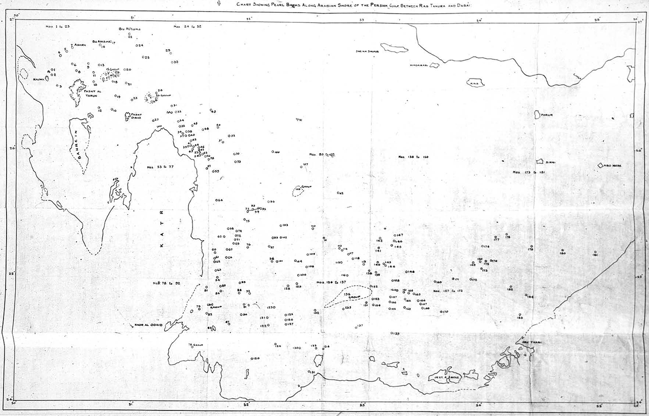
Note that historians can coax a more volumetric, contoured, material sense of the ocean floor from Lorimer’s tabulated, statistical list that accompanies the map than from the flat image itself. In fact, the language of the annexure points to space underwater and encountered worlds that are anything but two-dimensional. Consider the Arabic names for each hair, which Lorimer included, listed in a numerically organized table. The names include references to wadi (valley), Khor (alcove), Harf (narrow shoreline), Najwah (elevated land), Hawād (sharp ridges), Sateh/Sutūh (flatlands); Baten/Butun/Batin (stomach or a concave area[?]); Dhaher/Dhahur (back or a flat elevated area); Riqqa (lush regions); ‘umairah (beehives), Ri’ah (elevated land), Rās (head or cape), and other kinds of terrain.Footnote 59 We meet a world of diverse landscapes and varied encounters that cross the human and material world. Persian words are scattered through the names for hair, such as the reefs numbered 6 and 19, which use the Persian word for an alcove or bay, khor. Some of these references, and whether they generated specific memories or humor or dread for local sailors and seafarers, are unclear: what might the name of number 41, abu kalb, “a father of a dog,” have referred to? Although what these specific place names referred to for certain seafaring groups is harder for the historian to access, even in the two-dimensional archive, traces remain of these social elements of encountered worlds where human experience met the material seabed.
We can compare Lorimer’s “Chart” against similar imperial and colonial attempts to map submarine reefs in the Gulf of Mannar. Like Mergui and the Persian Gulf, the hydrological, meteorological, and physio-chemical parameters of this body of water were well-suited to the pearl oysters that settle and grow in communities on the seabed. These raised rocky platforms were known in Tamil as paars. Yet compared to the Persian Gulf the pearl-bearing reefs in Mannar had a longer history of entanglement with European empire reaching back to the sixteenth century. This is evident in the greater definition that imperial or colonial maps offered into the seafloor decades before Lorimer’s “Chart.” As Sanjay Subrahmanyam has pointed out, “One can scarcely find an enterprise then that encapsulates the phases of European ‘expansion’ in Asia better than the [pearl] fishery.”Footnote 60
In Ceylon, pearling constituted a valuable colonial monopoly and source of revenue: in years where a successful fishery was held, the revenues from pearling outweighed all other colonial monopolies, including cinnamon.Footnote 61 As Samuel Ostroff explains, even before British colonial interest in the region, the Portuguese and the Dutch were also concerned with the positions of the paars underwater and at sea.Footnote 62 One Dutch report from 1682 recorded thirty-one pearl banks, and a decade later forty-seven paars, and this divergence in the number of counted reefs indicates the molluscan mobility that would prove so difficult to pin down well into the twentieth century, when more “scientific” survey techniques were applied.Footnote 63
Ostroff’s work on the history of the Mannar Fishery between the Dutch and East India Company in the late eighteenth century offers a foundation from which to think about the colonial state’s approach to the seafloor at the turn of the twentieth century.Footnote 64 Conducted over three to four weeks in the lull between monsoons, the fishery was an important administrative and bureaucratic object.Footnote 65 Building on these older precedents as the nineteenth century advanced, an increasingly “scientific” approach tied to mapping, enumeration, and abstraction from terrestrial contexts was applied to the sea and its submerged reefs. Fewer maps were made to show the seafloor than the land, of course, but the desire to regulate the pearl fishery sponsored a mapping endeavor to capture the positions of oyster reefs on the ocean floor. This became the first submarine survey of Ceylon’s coastal shelf.
From the 1850s onward, administrators in Colombo also worked to reduce their reliance on local fishers, such as parava and maraikkaiyar caste leaders, whose estimates of oyster yields on the banks was a part-and-parcel of the colonial monopoly.Footnote 66 Mapping ensured that information about the underwater realm was in the hands of the state as opposed to local elites with their specialized, caste-based knowledge. As early as 1869, European fishery inspectors argued, “Any new series [of fisheries] can only be worked out successfully to the end … by a reliable plan and record of the position and extent of each patch or bed of oysters of the different ages.”Footnote 67
The chart made up in 1892 by the long-term administrator, the English naval officer turned pearl fishery Superintendent William Twynam, was the most extensive cartographic endeavor hitherto of the underwater environment in the Gulf of Mannar.Footnote 68 His Report on the Pearl Fisheries of Ceylon (Colombo, 1902) was heralded as the most exhaustive compilation yet of fishery statistics.Footnote 69 The Report included data on divers, boats, fishery camp arrangements, fiscal matters, and other administrative details around the fishery, as well as records from past fisheries.Footnote 70 It also included a map of the seafloor in the Gulf of Mannar, the “Chart Showing the Banks Fished from Marichchukkaddi” (Image 2), printed at the lithographic Surveyor General’s Office in Colombo.
William C. Twynam, “Chart Showing the Banks Fished off Marichchukkadi, 1889, 1:200000 scale, in Report on the Ceylon Pearl Fisheries” (Colombo: Government Press, 1902).
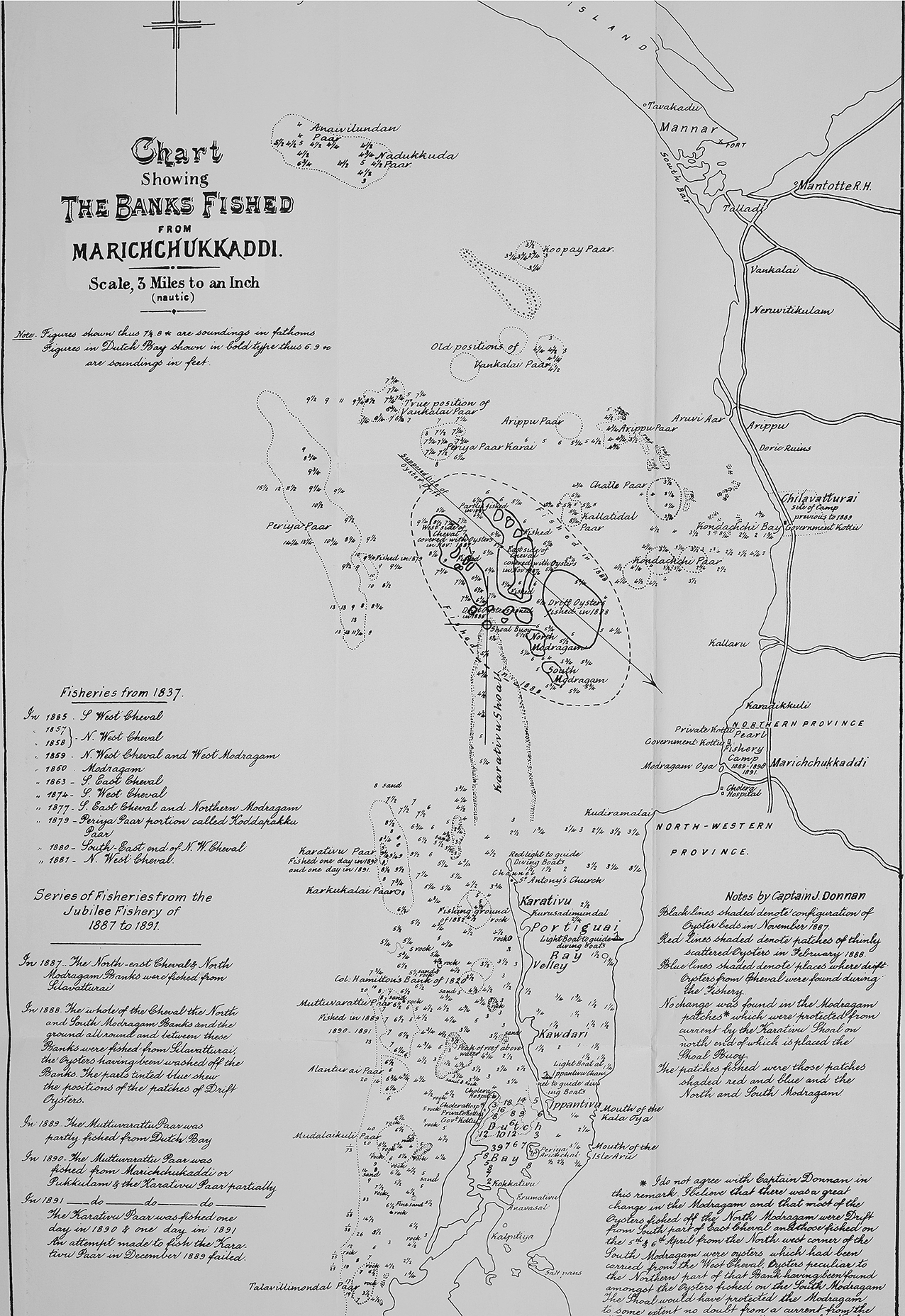
Here, as with the Persian Gulf Gazetteer, rendering the seafloor visible meant stripping away the material realities of the sea and maritime labor. Twynam’s chart frames the coast from the spit of Kalpitiya up to Mannar island. There is little indication of the topology of the shore, although the towns and rivers are marked with more accuracy here than on Lorimer’s map. At sea, by contrast, small, disconnected, scratchings are scattered like constellations across the surface to mark the pearl banks, alongside extensive depth soundings labeled in fathoms. These markers, akin to Lorimer’s circles, represent beds fished during fisheries conducted from 1837 to 1891, folding layers of history and human extraction into the image of where oysters lay on the seabed. Although in reality reaching oysters took place underwater, here on the map the seafloor was written onto the surface. Thus “peak of reef above water” is not distinguished from the paars on the seafloor and their accompanying terrains, including “rock,” “sand,” or “fine sand.” Unlike Lorimer’s “Chart,” Twynam’s map rendered depth and its variability by marking it on the map, and also the various shapes of each paar using dotted outlines. Similar to Lorimer’s tabulation, the names used for each pearl bank preserves traces of local expertise, since it is fishers’ Tamil names for each paar that are inscribed.
As in the previous map, however, even before we turn to additional sources from the labor and scientific archive to build up a more materialist reading, this two-dimensional representation already preserves traces of animal histories. Uncertainty pervades the purportedly static “Chart Showing the Banks Fished from Marichchukkaddi.” Bivalve locomotive powers emerge in places where “old positions” of paars are given, from which the oyster bed had disappeared. In other cases, “true positions” are labeled (see Vankalai) compared with present sites. The “supposed line of oyster drift” is marked with a sure firm arrow which belies the rambling displacement of the paars over time.
Alongside Twynam, the fishery inspector, James Donnan, added his own key to the map that informed readers (implicitly) of these shifting oyster geographies. Donnan wrote, for instance, “Black lines shaded denote configuration of Oyster Beds in November 1887,” whereas, “Red lines shaded denote patches of thinly scattered oysters in February 1888.” Reading from the labor archive more broadly, we know that the economic, political, and social arrangements of fishing migrated in response to this: from 1796 to 1837 fisheries were held from Arippo, in the 1850s the camp was moved to Silavattuthurai, and finally in 1889 it shifted to Marichchukkadi, where the last fisheries took place.Footnote 71
A closer temporal equivalent to Lorimer’s “Chart Showing the Pearl Banks along the Arabian Shore” is the definitive mapping and list of paars produced between 1903 and 1906 as part of a Royal Society-sponsored scientific expedition, headed by Liverpool-based zoologist William Herdman, to research Ceylon’s pearl banks and oysters.Footnote 72 This expedition and its ensuing report were heralded as the first application of “practical biology,” which would bring “some degree of regularity in future in the [Ceylon] fishery returns.”Footnote 73 Herdman and his assistant James Hornell studied the pearl banks and their associated biota and compiled a systematic list of the paars, which marine biologists still cite today.Footnote 74
Lorimer had relied on political agents to obtain information from nakhodas to assess the condition of the paars, but Herdman sought to access the seafloor himself. He used a dredge, but also employed “lines of dives” from an inspection vessel, the Serendib. Footnote 75 Herdman’s two plates divided the Gulf of Mannar into “Chart of the Northern Paars” and “Chart of the Southern Paars.” On the hand-drawn map, dotted lines show loose outlines with the name of each paar: “West Cheval,” “Periya Paar,” “Dutch Paar,” “Inner Vankalai,” and so on. Conducting this underwater survey involved a vast human effort, provided by local divers whose names are elided from finished scientific publications. But these men are fully visible in Hornell’s photographic archive documenting the inspection, which contains images of them diving, surfacing, sorting shell, and examining oysters. On some individual “inspection sites” more than one hundred dives were made to enable Herdman’s compilation.Footnote 76
The third and final seafloor map I consider here comes from the opposite end of the Bay of Bengal. As the last volume of Herdman’s five-part Report on the Pearl Oyster Fisheries of Ceylon was published, another survey was underway in the Mergui Archipelago. Pedro Machado has recently catalogued how the colonial state in British Burma collected revenue through a system of leasing “blocks” at sea to capitalists, and then by selling licenses for each individual diving pump.Footnote 77 The question of which system would be most profitable, and how to manage the nascent industry, were foremost in administrators’ minds.
To make these calculations, knowledge of the seabed was required. R. N. Rudmose Brown and James Simpson’s Report on the Pearl Oyster Fisheries of the Mergui Archipelago was commissioned by colonial authorities in Rangoon, and the project resembles prospecting operations for tin, gold, jade, and other valuable commodities the British worked to extract from Burma, as Thant Myint-U has described.Footnote 78 Like Herdman, Rudmose Brown and Simpson were appointed on the basis of nascent oceanographic and marine research in the colonial metropole; except that in practice, and at sea, in the variable environments of the Indian Ocean, these skills were coupled with the expertise of local seamen and sailors.Footnote 79
Predictably, and in line with other land-based prospecting operations, Rudmose Brown and Simpson’s report was an exhortation to intensify pearling, further north and south of the town of Mergui. In these new stretches of unfished ocean, they declared, were “exceedingly valuable beds, better than most in the Archipelago” still untapped.Footnote 80 With their report they submitted a large, hand-drawn map, “Sketch Map to Illustrate the Pearl Oyster Banks of the Mergui Archipelago & Moskos Islands” (see supplemental image 1) to accompany six pages of descriptions of over fifty island and reef candidates. This map runs several feet in length, and traces oceanic space from the Moskos islands past the mouth of the Tavoy river, and through the rich archipelago around Mergui. It terminates at the mouth of the Pak Chan River, where a rough hand-drawn blue line marks the “Boundary between Burma and Siam.” The map aggregated the ocean floor into commercially viable space by offering three demarcations: a solid red line for “[pearling] ground workable throughout”; a thinner line to show “area with scattered but workable grounds”; and a dotted line indicating “banks of minor importance or not examined in detail.” These inscriptions against the world of multiple islands and reefs draw the eye in—the focus is not on the landscape of the islands or coasts, but what lies between them—in this case the shading refers to animal habitat. But this was a selective gaze that showed only the home of one specific animal: the pearl and mother of pearl-bearing oyster.
Like Lorimer’s, Twynam’s, and Herdman’s maps, Rudmose Brown and Simpson’s “Sketch Map” represents what Denis Cosgrove called the “Apollonian Eye”—it offers a systematic view from above, which renders the seafloor, normally submerged by a material and turbulent sea, into knowable terrain.Footnote 81 But this was a particular kind of inscription which reproduced a kind of visibility that privileged revenue from a single species above all else. They contrasted their findings with a memo filed by the Deputy Commissioner of Mergui in 1903 that listed only ten pearl banks.Footnote 82 This discrepancy is revealing: forty new pearling grounds did not simply appear between 1903 and 1907—seafloor ecologies and ecological niches were not assembled ex nihilo in those five years. Rather, Rudmose Brown and Simpson wrote into being certain sites on the ocean floor as commercially viable.
Human Mobility: Lateral and Vertical
The maps thus far have fashioned a prospectus for the sea as a space of commercial extraction. In order for found environments to be translated into two-dimensional images, in the absence of any kind of drone or satellite technology, a panoptic view of the pearl bearing reefs at sea “from above” required a view “from below.” Human laborers ventured down to the ocean floor to send up reports about the position and extent of oyster communities. How might historians access traces of what was elided? For, in fact, the uncluttered appearance of the maps belies the world that divers encountered, which was textured, varied, dynamic, and rich with other submarine life. Moreover, it ignores the experience of diving to retrieve this information. Folded into these finished cartographic projects, then, is the haptic, the olfactory, the visual and embodied, and cultural experiences of divers and other beings.
To explore the construction of Lorimer’s “Chart” we can turn to extant India Office correspondence. He assigned the task of collating information on the pearl banks to British officials stationed across the Persian Gulf. In Bahrain in 1906, for example, the agent Francis Prideaux was “trying to get the positions of the Pearl banks on our side of the Gulf marked down on the Chart” and had successfully “identified practically all of those which lie South of Ras Tamura.”Footnote 83 This was derived entirely from the knowledge of local nakhodas, who had a “wonderfully correct knowledge of the depths of all the Banks.” Only a few of their names survive, such as Saleh in Kuwait, although there is welcome new historical work based on Arabic-language materials which is increasingly foregrounding these figures in the history of imperialism in the Gulf region.Footnote 84 Over the next months, at Bahrain, Kuwait, Sharjah, and Lingeh, information was transferred from local nakhodas to colonial officials.
The maritime worlds into which colonial knowledge of the sea intruded had long-established traditions of both navigation and cartography—the plural ways of making sense at and of the sea were hardly invented by the high imperial moment. Seafaring expertise in the Persian Gulf had long circulated orally as well as in texts, including works by al-Idrisi, Ibn-Battuta, Ibn Majid, and Kātib Çelebī.Footnote 85 The nakhoda who passed Arab navigational information to the British orientalist James Prinsep in 1836 also included a book, an object so valuable to its owner that “without [it] he would doubtless have been greatly at a loss on his return voyage.”Footnote 86 New scholarship is shedding much needed light on these practices of Arab seafaring and science at sea.Footnote 87 In addition to such texts, experience mattered greatly.Footnote 88 Similarly, in Mannar, before these definitive lists of pearl banks were compiled, officials such as James Steuart described the Tamil adapannars, who “appear to read the compass, and to have the same fixed courses, as steered by their ancestors, from Arippo to their variously named pearl banks,” indicating lifetimes of experience locating reefs.Footnote 89 In the same fashion, early prospecting of Mergui drew on regional seamen: a Filipino man named Fernandez guided the Queensland pearler Frank Jardine through the archipelago in 1894.Footnote 90
Listing and plotting the pearl banks involved mediation across hierarchies, as captains and headmen passed on information to colonial authorities. But already in this translation elements of seaborne navigation and material worlds were lost. Nakhodas, for instance, captained dhows, baggalas, or sambuks, and navigated using wind, sail, and shore-based landmarks. At night they used the stars and constellations. When the Bahraini nakhoda Rashid bin Fadil Al Bin ‘Ali published Majari al-Hidaya (Routes of guidance), which described the positions of the pearl banks in 1920, he provided information on the stars, shore-based landmarks, and other sail-based instructions. He included which angles to tack at from the shore to reach particular locations, as well as the conditions of the seafloor, alternatively sandy, muddy, or too shallow for certain vessels.Footnote 91 Sailing required making measurement and calculations, and much celestial and shore-based navigational expertise. Similarly, in the Gulf of Mannar experienced sailors and helmsmen used the color of the ocean and sky and even the smell of mud from the ocean floor.Footnote 92 These sensory elements of navigation are absent in the finished maps: the sea is flat and colorless, the stars are hidden, and the waves are silent.
Lifetimes of experience alongside and in the waters of these oceans shaped the skills that divers and sailors acquired navigating, swimming, and diving, which enabled the collection of information to make submarine maps. Europeans present at the Indian Ocean fisheries almost never ventured underwater, although in Ceylon two or three Europeans used suits to conduct scientific surveys in 1903 and 1912. When the historian reads the fixed, bounded contours of the pearl banks on the map, we need to consider how divers’ submarine journeys and spatial understandings departed from this. Arabic-language texts, for instance, explained that “there are no clear geographical boundaries between these [pearl] banks. They exist only in the minds of the divers and in the nature of the seabed.”Footnote 93 Divers knew the underwater world to be dynamic and variable and used their senses to detect quarry. Divers thus became experts at locating oysters—a skill Japanese ama refer to as “reading the face of the reefs.”Footnote 94 In Mergui, for instance, divers knew to follow sites with “an abundance of gorgoniid, flesh and black corals,” or heavy currents, since these were a “prerequisite” for oysters.Footnote 95
Terrain is a relational concept that is produced and performed, and therefore must include human bodies and labor.Footnote 96 In the Persian Gulf and the Gulf of Mannar, divers used a weighted stone to expedite their descent to the seafloor. Generally, these submersions lasted less than a minute, although they varied with the experience and skill of the diver. Attending to the sensory experience of diving reveals that phenomenological readings of the maps are possible, that there is a “bodiliness” in them.Footnote 97 Traces of the impact of diving and the ocean on the body are evident across the pearl fisheries: assisting Jardine with his survey, one diver working around Russel Island in Mergui found that the ground underwater was so muddy that he “sank to the tops of [his] thighs.” Footnote 98 In other places, the seafloor these men encountered was deep enough to be as “dark as night.” Literary works also provide clues into divers’ experiences. Tamil poetry in the Gulf of Mannar, such as verses by the poet Ammūvaṉār, explain how, underwater, the ocean’s waves sounded like human voices, akin to circulating village gossip.Footnote 99
If the maps I have surveyed here resulted from the labor of diving to assess where oysters lay, and the transition between air and water, surface and submarine, then the labor and medical archive especially helps illustrate what happens when species touch in fraught zones.Footnote 100 Water’s density is approximately a thousand times that of sea level air.Footnote 101 Each dive to reach oysters resulted in significant changes in the body, including vasoconstriction, CO2 retention, and trouble with temperature regulation. Divers were stung by jellyfish and had their fingers and feet cut by coral or rock.Footnote 102 In Ceylon, multiple submersions frequently caused “ear-ache and bleeding from the ear” or “severe pain in the chest.”Footnote 103 Similar conditions among divers were recorded by the American Mission Hospital in Bahrain, which alluded to the prevalence of skin rashes, perforated eardrums, and several lung problems.Footnote 104 At the other end of the Indian Ocean, within a single month in 1894 in Mergui, nine men suffered paralysis as a result of nitrogen narcosis in deep waters.Footnote 105 The matter of the ocean, then, was not bounded by the surface of the skin; it permeated the bloodstream and the body’s gases, crossing medium, body, blood vessel, and boundary.
I have traced how the production of a frozen image of the seafloor and its animal inhabitants was contingent on the embodied human experiences of descending underwater, and then translating these experiences to enable visibility. The most explicit rendering of the elisions entailed by translations between terrain, species, language, and experience entailed in reporting on the substrate of the ocean floor comes from the fisheries bulletins of the Ceylon Journal of Science. Footnote 106 In 1925, it reproduced the standard inspection sheet divers used, titled “Example of Divers’ Inspection Chart” (Image 3). We can use this document as an exemplar for any of the three sites I have surveyed, since all entailed similar processes in their making.
A typical example of an inspection chart showing the method of recording the divers’ reports by signs and numbers, in Joseph Pearson, A. H. Malpas, and J. C. Kerkham, “The Pearl Fishery of 1925,” Ceylon Journal of Science (Colombo: Colombo Museum), section C [Fisheries], vol. III, plate VIII.

The Chart is a sample of the papers that were distributed among helmsmen of boats when the colonial state went out from Mannar to survey the reefs. These were then collected and collated into finished reports. Each boat might have five or six divers and one helmsman who was responsible for filling out the chart. The Inspection Chart shows an area of 2 square miles. Four flags set off each corner of a grid divided into a matrix. The key, meanwhile, offers six symbols to choose from: a cross, x, to denote “spat [young oysters] too numerous to count”; a triangle for “flat rock”; two backward slashes // for “living coral”; a dot • for “sand”; and a single backward slash / for “weed.” Some quadrants contain numbers in circles to indicate old oysters.
Thinking with the inspection chart, and envisioning it in use, the layers of translation emerge quite clearly. First, divers descended into an ocean space, rolling with waves, currents, and other sea creatures, and bringing up twenty oysters per dive, which were counted and written down by the boat’s helmsman. The environment they observed, seeing it with their eyes but also feeling it with bare feet and hands—including broken shells, rocks, weeds, and living coral—was then transferred orally to the helmsman. Knowledge perceived in the body and underwater was thus performed as spoken language, and once received it was converted again into corresponding symbols written down on the chart. Translation occurs from water to air; across languages (primarily Tamil to English); between action and words; worlds and text; language and symbol, //, x, •, as the sea and the realities of labor were stripped away to produce an abstracted schema to enable extraction.
Animal and Material Mobilities
Thus far, we have explored the lives and experiences of the divers and sailors who helped to bridge the gap between the seafloor, the materiality of the ocean, and the waiting hands and eyes of colonial scientists, surveyors, or administrators. But can we approach this process from the bottom of the ocean itself? After all, “Terrain are, before any human intervention, always already inhabited,” and this is especially true in the ocean, a space without permanent human settlement.Footnote 107 It is therefore curious that while human mobility has been central to the framing of Indian Ocean studies, animal mobility has been almost entirely absent.Footnote 108 Traders, scholars, pilgrims, and laborers may have moved across the Indian Ocean’s waters, but there is virtually no consideration of other species moving. The work of geographers of the non-human is instructive here. Timothy Hodgetts and Jamie Lorimer, for instance, have urged scholars to adopt approaches that “prioritize the lived patterns and embodied experiences of animals.”Footnote 109 They also prefer the term “mobilities” to “movement,” since this “recognizes that animal movements are always produced within (and are productive of) relations of power between various actors.”Footnote 110 So, if oceanic mobilities transcend the human, where can traces of these other movements be accessed?
As I have noted, the locations of pearl beds, unlike extractive sites like diamond or gold mines, shifted frequently across years, weeks, and even days. Oyster movement resulted from variability in the seabed, ocean currents, storms, and tidal patterns. When historians attend to how the maps tried to grapple with the problem of oyster mobility, this allows them to reach for what Bear calls “aquatic liveliness.”Footnote 111 As Bear and Eden write in the context of the certification of contemporary fisheries, designating fixed areas at sea is complicated because “the utility of areal boundaries is rendered problematic by the materiality of the seas: coastlines change, fish swim, water moves and ships travel.”Footnote 112 They suggest, instead, a model of “hybrid geographies” that can attend to a “multiplicity of spatialities” that include animals’ patterns of mobility.
In each oyster reef map surveyed, it was near impossible to pin down the distribution of a living organism. Even if the geography of a pearl bank, defined by humans as a dense cluster of oysters, was imposed upon oysters from without, oysters themselves influenced this from within by living or dying, migrating, or settling in various sites over time.Footnote 113 Oysters moved because they were eaten or otherwise killed, could find no appropriate substrate to attach to, had insufficient food, were smothered by sand, or were overcrowded by other species.Footnote 114 Crucially, several million or billion died because humans lifted them from the ocean floor, which reduced the likelihood of a successful oyster population in the next year or forthcoming months.
The maps had no way to account for change over time, as reefs grew, shrank, or disappeared after a harvest. There were no cartographic keys for oyster death at sea or on land. Reefs in the Persian Gulf “failed” in 1770, 1790, 1878, 1900, 1905, 1950, and 2001—that is, there were not enough oysters on the ocean floor and some reefs had no oysters at all.Footnote 115 By 1907, the shallow waters in Mergui were “practically cleared of shell” and several formerly lucrative sites no longer hosted oysters.Footnote 116 Ceylon’s fishery was so intermittent that sometimes a decade would pass before a reef had a sufficient number of oysters to allow for a successful harvest.Footnote 117 The hairat, paars, or reefs and oysters exhibited nothing like the stability or economic guarantee of the sort the maps presented.
Oysters had their own temporalities and spatialities. Adult oysters on the ocean floor were made legible to divers and through their mediation and translation, but other stages of the oyster evaded humans altogether. Bear’s work on Atlantic salmon alerts us to the “complex spatialities of salmonid life” that include many different life stages, each lived in separate parts of rivers, streams, or the sea.Footnote 118 Similarly, the oyster, in its ordinary life cycle, passes through two stages: one mobile and one sedentary. In the former, long before they develop and grow their characteristic shells, they drift as eggs or sperm, and then, once fertilized, they become free-swimming young until they choose a place to settle in. Traces of these other life-stages are fleeting: one observer in Ceylon in 1799 described fertilized spawn on the sea surface “connected together by a slimy substance; this seed is deposited in great quantities.”Footnote 119
Having recognized that oysters lived lives beyond the maps, we must ask where to locate microscopic larvae, tiny free-floating fertilized creatures whose shells had not yet developed, or young oysters that landed and disappeared from reefs? Intimations of these unseen, untraceable oysters sometimes emerge through absence. In Mannar, officials speculated about oyster stocks on the opposite coast restocking the banks with young spawn.Footnote 120 Similarly, in the Persian Gulf, divers and nakhodas asserted that there were oysters living in deeper waters beyond where divers could descend; hence “the local belief that the spoliation of the deeper beds would injure the shallow sea.”Footnote 121 Although the question of whether “it is possible that such deep-sea pearl beds exist” remained unanswered, it was conceivable that they did, which alluded to animal life and mobility beyond the scope of the map.Footnote 122
In terms of animal mobilities, one might consider other animals besides humans that hunted and killed oysters. Twynam’s report included comments on other mollusks, rays, trigger fish, and sponges that ate or competed with oysters for submarine space, labeling these creatures the oyster’s “enemies.”Footnote 123 Scholars working in animal geography have insisted that these creatures also possess the agency to sting, trample, burrow, dig, feed, build, dam, and excavate, and thus transform landscapes,Footnote 124 and indeed they did on the Indian Ocean floor. Starfish and sea urchins ate oysters, “submarine borers and grubs” wore through their shells, and sharks fed on fish that showed up to eat oysters.Footnote 125
Although these animals’ experiences largely fall out of the purview of the textual archive, we can find traces of them: Moken divers in Mergui told stories about whales and sea turtles, while the Tamil parava divers of the Gulf of Mannar both dreaded and fought against sharks.Footnote 126 Jellyfish were universally feared.Footnote 127 Other creatures made inadvertent entries to the archive, such as the barnacles that so frequently attached to fishery vessels that some boat owners complained that there was hardly a single hull that was “clean and unfouled.”Footnote 128 In these coarse and feared patterns that peek out from the fishery archive, the historian is alerted to a more populous seascape than the maps indicate.
Mobility applied not just to creatures but to the sea itself. As oysters moved, so too did the ocean, rising and falling with the tides, with different currents, storms, and undersea sand movements. As Squire explains regarding her work on the U.S. SEALAB experiments in the 1960s, “Terrain cannot be understood without first paying due attention to the water in which it is immersed and inseparable from.”Footnote 129 And indeed, the ocean affected pearling directly. In Ceylon there were two distinct times of the year when oysters would spawn, coinciding with warmer sea temperature. The monsoon was frequently thought to throw up sand underwater which suffocated oysters. In Mergui, work during the spring tide was near impossible: around Quoin Island, “The exposure to the ocean swell from the west is likely to provide disastrous to successful work at most periods,” while around Elphinstone Island divers found that “they cannot withstand the force of these currents and their pipes and lifeline are in great danger of becoming entangled with the rocks.”Footnote 130 River runoff affected oysters in all three pearling sites, as outflows from the Pak Chan River in Burma/Siam, the Man Aru in Mannar, and the Tigris, Euphrates, and Karun in the Persian Gulf changed the sea’s composition. Atmospheric features and ocean currents shaped where a pearl-bearing shoal of oysters would settle and grow.
Although historians may shy from attributing “agency” to nature, pearlers, sailors, and divers did. Hornell wrote of the paars in the Gulf of Mannar, “The controlling factors are many, but it is certain that the most important are the character of the weather and the direction and strength of the currents at the time [oyster] spawning takes place.”Footnote 131 Likewise, Jardine wrote about pearling seasons in Mergui, “Nature in her climatic arrangements had provided a ‘close’ season herself.”Footnote 132 “Nature” was very much conspicuous and present at the fisheries, as it is even in the historic archive.
Domestication
Once rendered visible, translated by the work of divers and other intermediaries across terrain, language, and species, oysters entered into new imperial attempts to order and domesticate life below the waterline. The texts that accompanied each map made reference to ecologies in other sites of pearling. These extractive industries generated new forms of categorization meant to make sense of the Indian Ocean as an ecological space, part of the longer narrative of attempts to domesticate sea life.
In the conclusion of Reports on the Pearl Oyster Fisheries of Ceylon, Herdman compared the coastal marine flora and fauna across “the northern part of the Indian Ocean.”Footnote 133 He conducted this comparison on shallow water species using side-by-side tables of relative abundance.Footnote 134 Overall, he concluded that Ceylon marine fauna “is more closely related to that of the Malay region and Australia than to that of the Maldives or the Red Sea.”Footnote 135 He singled out Mergui: “The number of general species common to the two areas [Mergui and Ceylon] is, however, great, and many species are closely allied.”Footnote 136
Herdman’s research on Ceylon’s oysters became a template for reading oysters in the Indian Ocean. Consider how Lorimer constructed the life of Persian Gulf oysters based on Herdman’s research in Ceylon. He used the Ceylon paars as a proxy for the Persian Gulf hairat. Lorimer assumed, for example, that since a paar constituted “a bunch of Ceylon oysters [which] may consist of 3 to 16 individuals,” a hair was likely to be similar.Footnote 137 The Gazetteer of the Persian Gulf extrapolated from Herdman on oyster sex and reproduction: “the pearl oyster is not hermaphroditic”; on its life cycle: “the young oyster exists at first in free-swimming conditions”; its food: “microscopic organisms, both animal and vegetable”; its anatomy: “By means of this ‘foot’ [byssus] the oyster is able to travel”; its predators; how it formed pearls, through “the intrusion of a minute parasite”; and its mortality. The co-production of knowledge around oysters in Ceylon, contingent on a specific scientific-bureaucratic and labor complex, was thus imported and shaped the presentation of oyster reefs elsewhere. Despite this borrowing, Lorimer, too, was cautious, and noted that it was unclear “how far [the facts about Ceylon] hold good of the pearl oyster of the Persian Gulf.”Footnote 138
Similarly, Rudmose Brown and Simpson, while creating their maps of Mergui, also read Herdman.Footnote 139 They excerpted from his notes and included references to Ceylon’s oysters throughout their report.Footnote 140 The circulation of scientific knowledge through empire is hardly a new story, but what I want to underscore here is how particular interactions of bodies, beings, and knowledge shaped other sites of extraction. This was not a perfect example of copy-paste: although Rudmose Brown and Simpson agreed with Herdman that the Mergui oyster, too, relied on deep-water repopulation and that it had the same natural “enemies” and anatomy of the Ceylon oyster, they warned against extending the comparison too far.Footnote 141 There was an “essential difference” between the Mergui mother of pearl-bearing oysters and Ceylon oysters in terms of “The depths and conditions in which they live.”Footnote 142 They stressed that “the Mergui fisheries are of a quite different nature from those of Ceylon” and while they shared faunal commonalities, the nature of the seabed, the strength of the currents, the depth of the ocean floor, and the prevalence of hundreds of small rocky islands distinguished Mergui from Ceylon.Footnote 143
The way that oysters and different Indian Ocean sites fit together continued to crop up over the following decades. In 1939, colonial officials tried to prove that foreign encroachment into deeper Persian Gulf waters would hurt the oyster beds, and wrote to the British Museum in London seeking confirmation.Footnote 144 The museum responded with five recommendations, lifted directly from Herdman’s work on Ceylon. Once again, however, those with lived, working expertise in the region disagreed. “The habits of these two species I found very different,” one figure involved with the Red Sea fishery protested at the comparison between Ceylon and the Persian Gulf.Footnote 145 Material conditions in the Gulf “differ completely” from Ceylon, Cyril Crossland argued, because the oyster in Ceylon, in response to its surroundings, possessed a “constitutional delicacy.”Footnote 146
What we see here is not just the whims of empire, but a complex intra-action between imperial communications and scientific networks, oysters themselves, and the material conditions of each oceanic space, including its depth, currents, and other features.
Concurrent with the increasingly scientific perspective on the fisheries emerged a comparison of the aptitudes of labor. As the fisheries became more heterogenous in terms of their labor forces, they enabled new comparisons between human communities, often in the same process of reaching oysters. These made sense of diverse pearling workforces in increasingly racialized logics, which relayed human bodies to oysters, the ocean’s depth, and varying abilities to work for long periods underwater. Consider how Hornell included notes on the relative aptitudes of different racial groups for underwater work in his marine biology texts. He classed the different pearl divers into “racial types,” separating out “Coast Tamils” from South Indian Muslims, and “Malayalam men” from “so-called Arabs.”Footnote 147 These texts usually follow predictable patterns for early twentieth-century race science.Footnote 148 Hornell spent time describing how South Indian Muslims were “physically finer men than the Roman Catholic Tamils” as a result of “habit and environment, sobriety, superior food and personal cleanliness.” Alongside charts of sea surface temperature and oyster growth rate, Hornell included a table of “comparative diving endurance.”Footnote 149
The new presence of Persian Gulf divers was a particular boon to Hornell in his drive to increase pearling efficiency. “The Arabs are far ahead of all the others in endurance, their time underwater being generally from 70 to 85 seconds,” he wrote glowingly.Footnote 150 This assessment of superior diving ability was related to not just the length of time spent underwater but also the number of oysters retrieved: Arabs brought up forty to sixty oysters per dive, but Tamils only twenty-five. In other words, within the confines of an imperial system, animal and human interactions co-produced the concepts of racial aptitudes for diving.
Hornell’s comparative scheme of racial aptitudes shows how bodies and race were co-produced in the context of specific undersea environments and creatures. A similar process took place in Mergui. Jardine, the first pearler to definitively map the pearl beds, also provided a comparison of varying racial aptitudes for diving.Footnote 151 Rudmose Brown and Simpson likewise compared the Japanese, Filipino, Malay, Chinese, and Burmese divers in terms of time spent underwater, depths reached, and oyster yield. “Japanese divers are best in respect to the depths they descend … but however very reckless, and their rate of mortality is high.” They contrasted the Japanese diver to Filipinos who were “more reliable” but only went to 28 fathoms [51 meters].” Of course, European capitalists’ and colonial surveyors’ terms here, such as the Japanese divers’ competitiveness, elide entire local worlds such as Japanese ideas such as makemai seishin, competition to come home with the largest catch.Footnote 152 In other words, the depth of dives, the length of time spent underwater, and bodies’ ability to withstand the vicissitudes of submersion all emerged out of labor practices that brought diverse divers’ bodies into environments. Environments and their materiality, as well as other concepts, evolved relationally.
Conclusion
In the high imperial moment, long-standing local navigation practices at sea were folded into new, global projections of the seafloor that aimed to fix the position of submarine oyster reefs in cartographic form. To do this, each of the three examples I have examined removed entirely the materiality of the sea and its creatures and the beings that inhabited it, as pearling territory was constructed as a clearly visible strategic environment, oriented toward the state or capitalists. This colonial and imperial ordering of the seafloor and ocean space around the oyster aspired to make particular habitats named, mathematical, and calculable, although attempts to isolate and hold stable the oyster-as-object often failed. These pearling maps certainly accord with Steinberg and Peter’s observation that “cartographic logic of stasis and control, points and lines” fails when applied “to an ocean whose biogeophysical properties … are resistant to terrestrial ontology of bounded zones and emplaced points of power and knowledge.”Footnote 153
Scholars writing on cartography have asked, “Do maps find the world or do they make it up?”Footnote 154 This is a good question, but I suggest that we might frame it differently. Using the oyster reef at sea, I have shown how maps both encounter and make-up the worlds they find. In the first instance, the map meant that the oyster was rendered visible in specific ways in its encounter with the diver. Each circle or mark on the charts represents a site that was knowable and thus translated through the interactions of the state, capitalists, and divers. Each paar or hair or “workable area” thus represented an inscription of the human body and oyster ecology at a moment in time. In their making up, they affected the world, through fishing or further investments in capital or sovereign control, which in turn led to more harvesting and reefs becoming exhausted. This, again, altered the same agents depicted on the map.
Seeking to bring the Indian Ocean into dialogue with recent trends in spatial and multi-species history, I have argued that humans were constitutive of and co-produced with terrain and ecology, rather than external to them. Maps can be read creatively against and with other kinds of archival materials that speak to animal and human social and cultural worlds that, together, bound and created oceans historically. This allows us to construct more robust models for thinking through human pasts and futures in terms of our engagements with and productions of particular visions of the oceans, involving networks and webs of life and knowledge that transcend the ocean itself.
Acknowledgments
This paper benefitted from discussions with Sujit Sivasundaram’s world history reading group at Cambridge, who have all read far too much about oysters over the last years!
Supplementary Materials
To view supplementary material for this article, please visit http://doi.org/10.1017/S001041752200038X.


 Open access