

For almost 150 years the Galapagos Archipelago has been recognized as unique for its high terrestrial and marine endemism (Bensted-Smith et al., Reference Bensted-Smith, Powell and Dinerstein2002). These islands hold a special place in biology as it was Darwin’s visit to the Archipelago in 1835 that led to the description of numerous, previously unknown, species, many of which were to become pillars on which he built his theory of evolution through natural selection (Darwin, Reference Darwin1859; Hickman, Reference Hickman1985). However, the Galapagos Archipelago is now at a crossroads: its late human colonization has allowed retention of most of the original diversity of species but ecological degradation has proceeded rapidly as a result of land transformation through agriculture, urbanization and the impacts of exotic species. Pushed by external markets for tourism and demand for marine resources, the Archipelago is now undergoing an acceleration of economic and population growth, with an average annual population growth rate of 6.4% for residents and 9% for visitors (Charles Darwin Foundation et al., 2007). These development trends have coincided with 18 documented extinctions on the islands and the categorization of 200 of the 383 terrestrial animal and plant species as Vulnerable, Endangered or Critically Endangered on the IUCN Red List (Charles Darwin Foundation et al., 2007; IUCN, 2008).
Anthropogenic change, either indirect, through the introduction of invasive species and their subsequent establishment, or direct, through habitat modification and destruction, is the cause of the decline of many Galapagos terrestrial species (Hamann, Reference Hamann and Perry1984; Tye et al., Reference Tye, Snell, Peck and Andersen2002; Watkins & Cruz, Reference Watkins and Cruz2007). Despite ongoing degradation from the increase in the human population and tourism, there has been only a limited effort to assess the extent of human disturbance across the islands or across the vegetation zones of each island (Bensted-Smith, Reference Bensted-Smith2002). Given documented species losses and the growing list of threatened species, conservation efforts will need to maintain and restore as much native vegetation as possible but, for this, evaluation of the current situation is needed. Here, we build on previous work (e.g. Snell et al., Reference Tye, Snell, Peck and Andersen2002) to provide a comparative spatial analysis and quantification of the impact of anthropogenic degradation on the main vegetation zones of the inhabited islands of the Archipelago.
A total of 128 islands, islets and rocks have been named in the Galapagos Archipelago (Tye et al., Reference Tye, Snell, Peck and Andersen2002). Only five of these are currently inhabited by humans: Baltra, Floreana, Santa Cruz, San Cristobal and southern Isabela (although not an island by itself, we distinguish it from northern Isabela because of the impassable lava flow that ecologically separates south from north). A sixth island, Santiago, was temporarily settled by humans for a few brief periods until the 1960s (Fig. 1).
Vegetation zones on the the six inhabited or formerly inhabited islands of the Galapagos Archipelago. The dotted line indicates the divide between northern and southern Isabela.
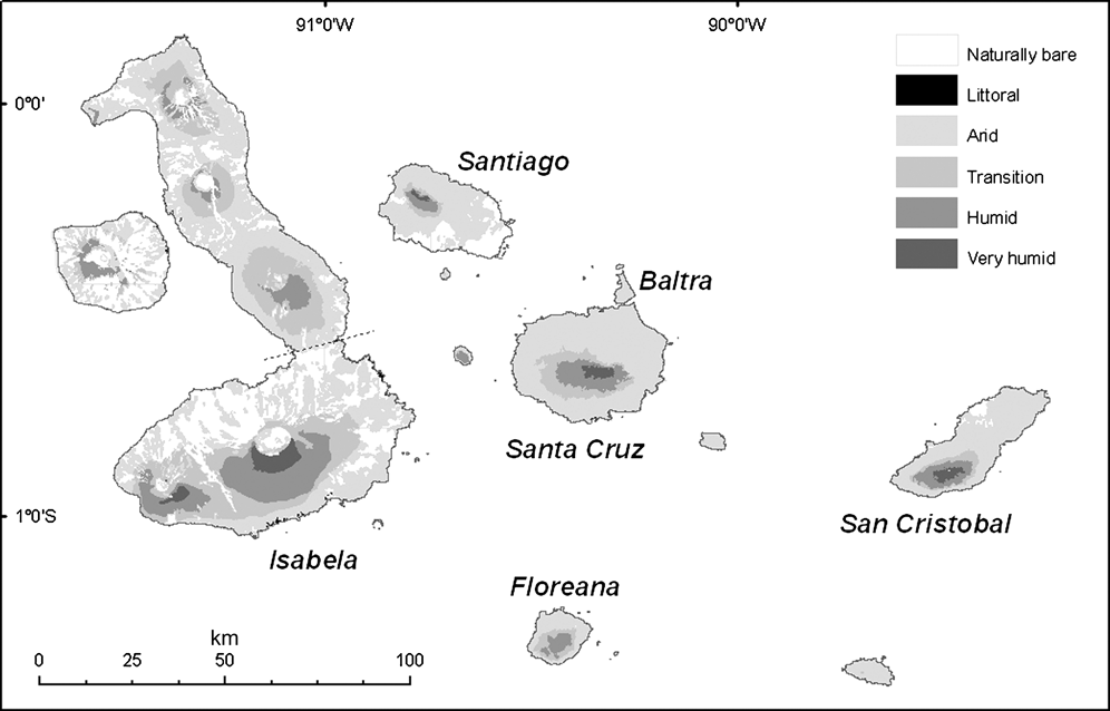
Each island is distinct in its evolutionary history and specific biological and geographical characteristics. A common feature, however, is the presence of compressed altitudinal vegetation zones because of arid warm conditions at low elevations, wet cool conditions of the higher areas and wetter conditions on the windward southern sides of the islands (Jackson, Reference Jackson1993). Classification of these vegetation zones differs subtly between various authorities but six or seven zones are generally recognized (Wiggins & Porter, Reference Wiggins and Porter1971; Jackson, Reference Jackson1993; Snell et al., Reference Snell, Tye, Causton and Bensted-Smith2002). We refer to six major vegetation zones based on the descriptions of Wiggins & Porter (Reference Wiggins and Porter1971): (1) naturally bare zone, which comprises lava rocks, beaches and lagoons; (2) littoral zone, of which the dominant plants are shrubs and small trees, including mangroves and other salt-tolerant species; (3) arid zone, with xerophytic vegetation dominated by low scrub and arborescent and shrubby cactus species of the genus Opuntia; (4) transition zone, which contains a mixture of vegetation from the lower and higher zones but with significant tree cover; (5) humid zone, largely dominated by species of the endemic genus Scalesia; (6) very humid zone, predominantly composed of Miconia robinsoniana, sedges and ferns.
To quantify the impact of human activity we calculated the area of each island that has been significantly degraded by human habitation or invasive plants. These areas were also calculated within each of the vegetation zones. We delineated the area that had been subject to anthropogenic degradation as the sum of (1) the total area that comprises highland agricultural zones and lowland urban zones inhabited by humans and that does not constitute part of the National Park, as mapped by Galapagos National Park rangers in 2008 using a global positioning system, and (2) the area mapped, by TNC & CLIRSEN (2006) using satellite imagery, as being heavily invaded by four alien plant species (Psidium guajava, Rubus niveus, Cinchona pubescens and Syzygium jambos) and that includes some National Park areas contiguous to the highland agricultural zones. Using ArcMap v. 9.2 (ESRI, Redlands, USA), we intersected anthropogenic degradation maps with the six vegetation zones across the main inhabited (or previously inhabited) islands. As there are no available data that would permit quantification of the area degraded by introduced animals, such as goats, pigs or rats, our definition of anthropogenic degradation excludes this important category of indirect human impact. Our analysis does not consider Baltra, a small inhabited island north of Santa Cruz (Fig. 1), which currently has an airport, military instalments and personnel but no civilian inhabitants, and for which no data on vegetation zones are available.
Our analysis shows that 5% (13,394 ha) and 8% (1,296 ha) of Isabela and Floreana, respectively, is degraded (Table 1). Proportionally, Santa Cruz and San Cristobal are the most modified, with 14% (13,585 ha) and 17% (9,547 ha), respectively, of their land area affected. However, if the total rather than the percentage area affected is considered, the modified area of Isabela, even though the island is not as populous as Santa Cruz and San Cristobal, is similar to the smaller, more densely inhabited islands. This is because Isabela has more extensive humid and very humid vegetation zones, and these are the most prone to colonization by invasive plant species, especially following fires.
Total area (ha) and perecentage modifed by human activities (in parentheses) of the six vegetation zones on the five inhabited or formerly inhabited islands of the Galapagos Archipelago (Fig. 1).
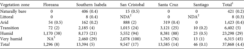
1 Percentages are for degradation of the zone across the whole Archipelago
2 NDA, no data available as this vegetation zone has not been mapped on these islands
3 NA, not applicable as vegetation zone does not occur on the island in question
A total of 37,833 ha of the Galapagos Archipelago’s main inhabited (or previously inhabited) islands have been disturbed by human activities. Although this disturbed land represents only 5% of the total land area it does not necessarily indicate that there has been relatively little human impact. The summed area of each vegetation zone shows that although some vegetation zones (naturally bare, littoral and arid) have been subject to minimal human impact (< 1% modification), others have been extremely modified (e.g. 29 and 45% of the humid and very humid zones have been altered, respectively; Table 1). When these zones are considered by island 94 and 100% of the humid and very humid zones, respectively, have been degraded on San Cristobal, and 88 and 76% of the humid and very humid zones, respectively, on Santa Cruz.
These results contradict the image often portrayed of a pristine Galapagos Archipelago little affected by humans. Although settlement on the islands was relatively recent (the first permanent inhabitants settled on Floreana in 1832) humans have already had a substantial effect. Conversion of the most fertile and arable areas has destroyed large tracts of the highlands. Agriculture has, however, proved to be only marginally viable as an economic activity and hence much of this land now lies fallow and increasingly infested with non-native species. While it is not possible to diagnose the full ramifications of two of the largest islands losing most of their humid zone vegetation, impacts on native species are already evident. Plant species such as Scalesia pedunculata, Scalesia cordata, Cyathea weatherbyana and Darwinothamnus tenuifolius now only occur in isolated patches. Bird species such as the warbler finch Certhidea olivacea and Galapagos rail Laterallus spilonotus occur at much higher densities than formerly in uninfested remnants of humid and very humid vegetation zones (Gibbs et al., Reference Gibbs, Gregory Shriver and Vargas2003; B. Fessl, pers. comm.), suggesting their habitat range has been considerably reduced by habitat conversion and invasive species. The area that contains threatened Galapagos petrel Pterodroma phaeopygia burrows has also contracted considerably because of habitat degradation (BirdLife International, 2009).
In the long-term the cost of restoration is hundreds of times greater than that of protection (Possingham et al., Reference Possingham, Andelman, Noon, Trombulak, Pulliam, Orians and Soulé2001). However, on the Galapagos, as a large proportion of the vegetation has already been significantly altered and protection of the remaining fragments against invasion may not be possible, there is a need for strategic restoration. It is unlikely that human pressures on the islands are going to decrease in the near future, and therefore landowners and agricultural communities living within the productive landscapes will need to play a proactive role in land stewardship. There is a need to determine how best to restore these areas and to what end point restoration is aiming. Some restoration efforts have already been undertaken, most famously Project Isabela (Lavoie et al., Reference Lavoie, Cruz, Carrion, Campbell, Donland, Harcourt and Moya2007; Charles Darwin Foundation, 2009). Such restoration efforts will need to include simultaneous efforts to protect species and ecosystems that are declining because of other threats (such as introduced predators) across the Archipelago.
Our aim in this study was to raise awareness of the problems of vegetation change on the islands and to help identify initial priority zones for restoration. The maps used in our analysis are coarse (but the best available) and probably reflect significant underestimations of degradation in areas that were not well mapped. For example, anecdotal information suggests that the humid zone of Floreana has been significantly more affected by agricultural activities than available maps suggest. We could not take into account the effects of introduced animals on the native vegetation and it is known that the vegetation of several of the uninhabited islands has been severely affected by introduced herbivores (Lavoie et al., Reference Lavoie, Cruz, Carrion, Campbell, Donland, Harcourt and Moya2007). Nevertheless, our analysis has highlighted the need for detailed spatial mapping of the direct and indirect impacts of human presence on the Galapagos Archipelago and for a concerted effort between all relevant organisations to restore the humid highlands before these important species-rich zones disappear forever.
Biographical sketches
James Watson’s research interests are in optimizing restoration activities in degraded landscapes to ensure the best biodiversity outcomes. Mandy Trueman is a spatial scientist currently studying alien plant invasions in the Archipelago. Marta Tufet is a scientific writer currently based in Galapagos. Scott Henderson is Conservation International’s Regional Director of Marine Conservation in the Andes and Eastern Tropical Pacific regions, with special interests in marine conservation and invasive species. Rachel Atkinson is coordinator of the programme Solutions for Ecological Restoration at the Charles Darwin Foundation, specializing in invasive plant control.


