

Introduction
As the final generation of survivors of the First World War has now passed away, the importance of archaeology and the landscape itself as the last remaining witnesses of the conflict is growing rapidly (Chielens Reference Chielens, Chielens, Dendooven and Decoodt2006; Stichelbaut & Chielens Reference Stichelbaut, Stichelbaut and Cowley2016). The potential of contemporary aerial photography to enable the study of these conflict-marked landscapes and their associated archaeology has already been acknowledged (de Meyer Reference de Meyer and Demeyere2006, Reference de Meyer, Stichelbaut, Bourgeois, Saunders and Chielens2009; Stichelbaut Reference Stichelbaut2006). Since the origins of ‘modern conflict archaeology’ at the beginning of the twenty-first century (Saunders Reference Saunders2002), field research on First World War sites and desktop analysis of First World War aerial photographs have become part of mainstream historical archaeology in Flanders (Van Hollebeeke et al. Reference Van Hollebeeke, Stichelbaut and Bourgeois2014).
Appreciation of the application of historical aerial photographs to archaeology is growing (Cowley & Stichelbaut Reference Cowley and Stichelbaut2012; Hanson & Oltean Reference Hanson and Oltean2013), and access to archival photographs is being facilitated by means of ongoing digitisation programmes and the development of new discovery aids (Cowley et al. Reference Cowley, Ferguson, Williams, Hanson and Oltean2013: 21–22). Occasionally, historical photographs are used to document sites of twentieth-century conflict (Gaffney et al. Reference Gaffney, Gater, Saunders and Adcock2004; Kaimaris Reference Kaimaris2011), but apart from the English Heritage National Mapping Project (Winton & Horne Reference Winton, Horne, Cowley, Standring and Abicht2010; Horne Reference Horne and Cowley2011), there are few examples of regional-scale implementation for archaeological purposes. Even fewer projects focus on the landscapes of past conflicts (Hegarty et al. Reference Hegarty, Newsome and Winton2005; Hegarty & Newsome Reference Hegarty and Newsome2007; Gheyle et al. Reference Gheyle, Dossche, Bourgeois, Stichelbaut and Eetvelde2013; Passmore et al. Reference Passmore, Harrison and Tunwell2014; Stichelbaut & Cowley Reference Stichelbaut and Cowley2016).
The thousands of aerial photographs taken between 1914 and 1918 covering the first 30km of the Western Front have already been examined (Stichelbaut Reference Stichelbaut2011). From 2011, we began the exhaustive mapping and analysis of the entire front in Belgium, focusing on the even more challenging conflict landscape near the town of Ypres. The study area includes the Ypres Salient (a bulge in the front line around the town of Ypres), the Wijtschate-Messines ridge, and the Allied and German hinterland: a region of up to 30km wide. The area was the scene of a four-year stalemate in the trenches and witnessed some of the fiercest battles of the First World War. Researchers have initiated mapping projects for heritage-management purposes, investigating parts of the Western Front in Belgium by digitising military features identified on contemporary military maps (de Meyer Reference de Meyer, Bourgeois and Meganck2005; de Meyer & Demeyere Reference de Meyer and Demeyere2006). Others have used maps to investigate the relationships between trench networks and the terrain (Doyle et al. Reference Doyle, Bennett, MacLeod, MacKay, Doyle and Bennett2002). This study presents the results of a GIS-aided mapping project using historical aerial photographs for research at a regional scale. In doing so, we demonstrate the potential for integrating remote-sensing data with aerial photography for the study of recent military landscapes.
The main research goals addressed by this study are: i) investigation of the extent of the First World War battlefields in Belgium; and ii) quantification of their structural components along with their geographic distribution. In addition, the research aims to: iii) examine the diversity of preserved First World War heritage in Belgium across the landscape; iv) determine if there are any differences between the Allied and German sides of the front; and v) explore how landscapes of different periods of the war overlap each other, and how military structures and sites changed as the war progressed.
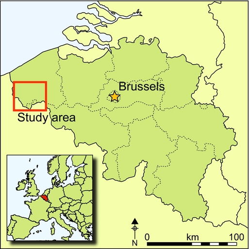
Study area, historical context and data collection
After the First Battle of Ypres (19 October–22 November 1914), the front stabilised and both the Allied and German armies entrenched themselves in an arc around Ypres, between 4 and 8km away from the town. Unlike the stable Belgian army front to the north (Stichelbaut Reference Stichelbaut2011), several large-scale offensives took place in the Ypres Salient. On 22 April 1915, German troops unleashed the first chlorine gas attack of the war. This marked the start of the Second Battle of Ypres (22 April–25 May 1915) in which the Allies were pushed back 5km before digging in again (Edmonds Reference Edmonds1928) (Figure 1). During the period between May 1915 and June 1917 there were no major offensives, although at a local scale there were many smaller actions, often aimed at capturing strategic heights. This resulted in numerous minor changes in the position of the front, often by just a couple of hundred metres. An example of such a small-scale battlefield (‘Caesar's Nose’) is presented as a case study below. On 7 June 1917, the Battle of Messines commenced when 19 deep mines—the effects of which can be seen at the Pool of Peace or Spanbroekmolen crater, for example (Figure 2, bottom)—were simultaneously detonated beneath key positions in the German front line, followed by a large-scale infantry attack (Passingham Reference Passingham1998). As a result, the Wijtschate-Messines Salient was successfully straightened as a prelude to the Third Battle of Ypres (31 July–10 November 1917), which aimed to destroy the German submarine bases along the Belgian coast (Edmonds Reference Edmonds1948). In the following months, the rain and continuous artillery fire transformed the battlefields into a shell-pocked, lunar-like landscape. On 10 November 1917, the failed offensive was stopped after the ruins of Passchendaele were captured and both sides dug themselves in again (Figure 1). Just five months later, all Allied gains made in 1917 were relinquished as a result of the German Spring Offensive (9–29 April 1918), which was halted just in front of the town of Ypres. This concise historical overview illustrates the complexity of the Ypres Salient as a stratified, multi-period conflict landscape.

Example comparison of typical aerial photographs. Top: British aerial photograph of Spanbroekmolen (just west of Wijtschate), taken on 1 June 1915 (reproduced by permission of the Imperial War Museum Box Collection, Box 15 B 588). Bottom: same area photographed by a German air crew on 16 September 1918 (reproduced by permission of the In Flanders Fields Museum). The comparison shows the impact of the war on the landscape and the density of features.

Research in the main archives of historical aerial photographs (Stichelbaut & Bourgeois Reference Stichelbaut and Bourgeois2009) and their subsequent digitisation resulted in a dataset of 9054 near-vertical aerial photographs taken between 30 December 1914 and 14 October 1918 (1914: number of photographs (n) = 1; 1915: n = 717; 1916: n = 1867; 1917: n = 3015; 1918: n = 3186; without date: n = 268), providing a visual and textured record of the progress of the First World War in the study area.
Results and interpretation
Studying the aerial photographs and the subsequent mapping of visible features resulted in a GIS-dataset of 162 417 features (some visible in Figure 3D) that have been interpreted and annotated with metadata (i.e. fields detailing typology, dating and nationality, and photographs used to map the features). The methodology used to map and date the features visible on the aerial photographs has been described in detail by Stichelbaut (Reference Stichelbaut and Bourgeois2009, Reference Stichelbaut2011). The following sections initially focus on a case study in the northern part of the Ypres Salient, explaining the complexity of the war landscape and the need for multi-temporal analysis of the historical remote-sensing data at site level, before moving on to discuss the landscape scale of the research.
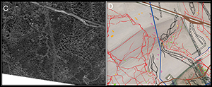
Example of landscape evolution: ‘Caesar's Nose’ case study. A) Aerial photograph of 28 April 1915 (reproduced by permission of the In Flanders Fields Museum); B) aerial photograph of 14 March 1916 (reproduced by permission of the In Flanders Fields Museum); C) aerial photograph of 21 February 1918 (reproduced by permission of the Imperial War Museum Box Collection 111-9B-249-1918-02-21); D) orthophoto 2014 (AGIV open data) with mapped war features from the beginning to the end of the war.

Caesar's Nose case study
The Caesar's Nose study area is located in the northern part of the Ypres Salient on the Pilkem Ridge (Figure 1). On 22 April 1915, during the Second Battle of Ypres, chlorine gas was released between Steenstraat and Langemark. That same evening, the front reached the edge of the study area and the German troops dug in along the higher ridges. An aerial photograph taken on 28 April 1915 shows the hastily dug and disorganised German and French front-line trenches (Figure 3A). On 16 May 1915, French troops launched localised counter-attacks and succeeded in capturing part of the German trench system, which they incorporated into their own field defences (2e bis Régiment de Marche de Zouaves 1915). As a result, a peculiar bulge was created in the German front line that became known as Caesar's Nose (Figure 3B). This was the start of more than two years of stable trench warfare, accompanied by an expansion of the trench system with more standardised types of firing and communication trenches. On 31 July 1917, the opening day of the Third Battle of Ypres, the area was captured by the 38th Welsh Division (Munby Reference Munby1920). The front shifted towards Passchendaele, and the function of this former battlefield changed to become a logistical hinterland. An aerial photograph taken in February 1918 shows military huts and roads, while a narrow-gauge railway crosses the landscape to ensure the supply of troops and materials to the front (Figure 3C). The present-day landscape bears almost no surface remains of the First World War with the exception of Caesar's Nose Cemetery (Figure 3D, bottom centre). Today, this cemetery holds the remains of 68 British soldiers who fell during the Third Battle of Ypres. It appears to be isolated on the landscape, and only by looking back at these aerial photographs of the Great War can the reason for its location be understood. The cemetery was located in the former area of no-man's land (see also Figure 3D), which was close to the location where the soldiers fell during the offensive, but, more importantly, was also where an unused open space has survived.
The mapping of 81 historical aerial photographs available for this site resulted in a plethora of war features. Archaeological excavations of the Allied and German front-line trenches—just 200m south to the edge of Figure 3—confirmed the preservation of the trenches and shelters below the surface (Verdegem Reference Verdegem2007). This small case study illustrates that the concept of the ‘front line’ was, to a degree, ephemeral and vague; and from an archaeological perspective, the whole zone is perhaps better regarded as a complex, multi-layered conflict landscape. The Ypres Salient comprises a superposition of First World War landscapes: battlefields that had become hinterlands and vice versa. This is in stark contrast to stable fronts such as the Belgian-German sector between Nieuwpoort and the Ypres Salient (Stichelbaut Reference Stichelbaut2011).
Ypres Salient landscape
The second level focuses on a broader area of the landscape. The general distribution map (Figures 4 & 5) and the table (Figure 6) provide a quantitative overview of the density, distribution and diversity of the mapped features in the Ypres Salient over the course of four years of warfare. For the purposes of visualising these maps, a distinction has been made between battlefield features (Figure 4) and hinterland structures (Figure 5), which together make up the multi-temporal conflict landscape of the First World War. The density of mapped features was previously unknown, and points to the industrial extent of the preserved conflict heritage. Although all features are mapped as polygon features, for ease of comparison and overview, they are presented in the table as ‘point’ features (i.e. bunkers and gun positions), linear features (trenches, railways and the like) and surface features (i.e. storage depots) (Figure 6). Constraints in the space available here mean that we can only present results for selected categories of features.
Map of the Ypres Salient with selected features such as mine craters, shelters (light shelters and open-air shelters), gun emplacements and concrete bunkers. Trenches are shown as a kernel density map.

Map of the Ypres Salient with selected hinterland features.

Overview of mapped features organised by functional classes.

Trenches
The trenches are the first category of military feature, and of these, more than 3500km were dug. The density of observed features contrasts sharply with the first 30km of the Western Front immediately to the north of this case study area, where only 417km have been identified in an area of comparable size (Stichelbaut Reference Stichelbaut2011). The earliest and most basic trenches are foxholes or slit trenches, which were nothing more than a hole in the ground providing cover for an infantryman. From the beginning of positional warfare in October/November 1914, to the start of the Battle of Messines, trenches were the main components of the defensive system and are among the most frequently excavated war remains in Belgium (Dewilde Reference Dewilde, Chielens, Dendooven and Decoodt2006; Dewilde et al. Reference Dewilde, de Meyer and Saunders2007, Reference Dewilde, Stichelbaut, Van Hollebeeke, Verboven and Wyffels2014; Van Hollebeeke et al. Reference Van Hollebeeke, Stichelbaut and Bourgeois2014; Gheyle et al. Reference Gheyle, Saey, Van Hollebeeke, Verplaetse, Note, Bourgeois, Van Meirvenne, Van Eetvelde and Stichelbaut2016). Trench systems comprised a combination of firing trenches, arranged in successive defensive positions, and communication trenches leading towards them. In mid 1917, the military doctrine changed and defences were organised in greater depth, with concrete bunker strongholds becoming increasingly important. In addition, it was no longer necessary to have uninterrupted trench lines, and these were replaced in many places by short stretches of trenches and shell holes that were used as shelters and transformed into vantage positions for firing (General Headquarters 1918). These shell holes are very difficult to identify, and it is probable that only a small proportion have been identified (Figure 7).
Allied and German trench networks in relation to the topography and main front lines.

Many typological differences can be noted, but the dominant categories are zigzag trenches (Défense Nationale 1925), which make up 59 per cent of the communication trenches, and trenches with U-shaped traverses (e.g. Stichelbaut & Chielens Reference Stichelbaut and Chielens2013: 191), which make up 39.4 per cent of the standard firing trenches. The close relationship between the natural topography of the landscape and the location of the trenches is evident in Figure 7. All the higher ridges are marked by clusters of trenches and were heavily contested places on the landscape. Visual dominance over the enemy's field defences was of the utmost importance, and many places such as Hooge, Bellewaarde, The Bluff and Sint-Elooi became the subject of intensive siege warfare, whereby sappers created tunnels and laid mines in an attempt to gain control of these hot spots (Barton et al. Reference Barton, Doyle and Vandewalle2004). Within the study area, this resulted in 300 large mine craters (Figure 4; Stichelbaut et al. Reference Stichelbaut, Gheyle, Saey, Van Eetvelde, Van Meirvenne, Note, Van den Berghe and Bourgeois2016).
The layout of the trench systems can be seen in Figure 7, which shows the nationality of the mapped trenches. Areas with mixed German and Allied trenches changed hands during offensives, and trench systems of different periods were superimposed upon each other, such as those near Polygon Wood. Even at this overview level, the structure of the trench systems and the extent of the Ypres Salient are evident. Two main fronts can be clearly identified: i) the ‘outer Ypres Salient’—the front line prior to the Second Battle of Ypres—comprising a narrow zone of trenches (see for instance Stichelbaut & Chielens Reference Stichelbaut and Chielens2013: 60–61, 69), which fits with the military doctrine early in the war wherein “the first line is to be held under all circumstances or retaken immediately in case it should be penetrated by the enemy” (General Headquarters 1918: 6); and ii) the ‘inner Ypres Salient’—the most elaborate trench system, which was developed from April 1915 to June 1917 and consisted of several successive positions arranged in great depth (Figure 7). After the Third Battle of Ypres, the trench networks were less extensive. This period is most easily understood by referring to Figure 5 where the whole military infrastructure (i.e. military roads, narrow-gauge railways, and wooden walkboards) are all oriented towards Paaschendaele to support the ongoing offensive. Following this offensive, the Allied trench system is visible as blue trenches in the area between the front lines. In some places, especially close to the German front, organised trenches gave way to occupied and fortified shell holes instead (e.g. Stichelbaut & Chielens Reference Stichelbaut and Chielens2013: 203; Figure 7).
As shown by recent geophysical investigations in the study area, the trenches are very well preserved below the surface (Masters & Stichelbaut Reference Masters and Stichelbaut2009; Stichelbaut et al. Reference Stichelbaut, Saey, Meeuws, Bourgeois, Van Meirvenne and Cowley2011; Saey et al. Reference Saey, Stichelbaut, Bourgeois, Van Eetvelde and Van Meirvenne2013, Reference Saey, Note, Gheyle, Stichelbaut, Bourgeois, Van Eetvelde and Van Meirvenne2016; Dewilde et al. Reference Dewilde, Stichelbaut, Van Hollebeeke, Verboven and Wyffels2014). A case study focusing on four sites in the village of Comines-Warneton in the southern part of the Wijtschate-Messines Salient (covering an area of approximately 28ha) showed that nearer the respective fronts, over 79 per cent of the trenches visible on aerial photographs have been preserved (Gheyle et al. Reference Gheyle, Saey, Van Hollebeeke, Verplaetse, Note, Bourgeois, Van Meirvenne, Van Eetvelde and Stichelbaut2016).
Bunkers, shelters and dugouts
Large numbers of constructions close to the trenches, if not incorporated into the parapet, provided varying levels of protection against the weather, shrapnel and even artillery fire. The lightest of these were open-air shelters, merely holes in the ground (Ministère de la Guerre 1916). Light shelters, comprising earthen and wooden-roofed structures, provided better cover. Some have been excavated, but very little remains of them except for some wooden floors (Association for World War Archaeology 2007a & b). Concrete was used for more solid constructions, such as bunkers and pill boxes. Their spatial distribution was not confined to the front-line area, but they were arranged into defensive positions ranging up to 15km deep (Figure 4 & 7). Strikingly, the greatest number of concrete shelters was recorded on the German part of the front line (Figure 6). This could represent a historical reality, linked to a more defensive military doctrine. On the other hand, the detection of German bunkers was made possible because of heavy artillery fire during the Third Battle of Ypres, which effectively destroyed their camouflage, increasing their visibility on aerial photographs. Hundreds of deep dugouts (Barton et al. Reference Barton, Doyle and Vandewalle2004) provided extensive cover at a depth of 5–15m below the surface (Jones Reference Jones2010), although only a few entrances have been detected on the aerial photographs because they were small and extensively camouflaged.
Logistical landscape
In addition to the battlefields and field defences, the aerial photographs and GIS mapping revealed an extensive logistical landscape in which the infrastructure of war that existed to support and maintain the fronts was located and could operate. A large network of narrow-gauge railways and military roads ensured the supply of ammunition, building materials and supplies from the areas at the rear towards the front (Figure 5). Troops were not always in the trenches but also spent considerable time in barracks and military camps located at safe distances from the front (Figure 5). Some buildings and tents are identifiable as aid posts or hospital sites. Their location is revealed by red-cross emblems, which were marked on roofs or on the ground to prevent them from being targeted by the artillery. The mapping of huts and barracks reveals a different approach in housing troops near the front. More barracks and huts can be seen on the Allied side than in German territory (Figures 5 & 6). Temporal analysis has shown that this most probably relates to the build-up of massive numbers of troops due to the Allied 1917 offensives.
The extent of the extensive Allied network of (plank) roads and duckboard tracks leading from Ypres to Passchendaele also relates to the 1917 offensive (Figure 5). The road network, which was built between September 1917 and March 1918, is an indication of the complete destruction of this landscape. The landscape had become so badly destroyed that it was otherwise untraversable. The front line in the crater fields could only be accessed by means of these roads and wooden plank boards. Hundreds of war cemeteries have been detected, showing the extent of a funerary landscape that far exceeds that of the present day. Hundreds of German war cemeteries have also been relocated in the post-war years, and human remains have been reburied in large aggregated cemeteries (Dendooven Reference Dendooven, Chielens, Dendooven and Decoodt2006). The discovery of this hidden and lost aspect of the battlefields opens up perspectives for further anthropological research of these landscapes. Farther away from the front, other sites can be identified, such as exercise trench systems mimicking front-line trenches and the battlefield environment by recreating no-man's land with artificial shell holes. These other hinterland sites include large numbers of ammunition and supply storage dumps and airfields.
Conclusions and future perspectives
This article is the first to present collated information from more than 9000 historical aerial photographs focusing on one of Belgium's most contested landscapes during the First World War. The sheer number of features mapped points to the industrial level of this military landscape and its associated archaeological heritage. The results of our research show, with unprecedented detail, the spatial extent of this war landscape in Belgium and the distribution of a variety of military features, while the data shows clear differences between the German and Allied landscapes. It also identifies how First World War landscapes of different time periods overlap.
The historical aerial photographic approach adopted here provides an understanding of this landscape and above all indicates where archaeological remains of the First World War might be expected to be found. Many of the mapped war-feature categories have only been archaeologically documented sporadically or sometimes never before. It is still too often the case that investigations into First World War sites are limited to the areas of the battlefields themselves where material remains of the First World War are expected to be found (Van Hollebeeke et al. Reference Van Hollebeeke, Stichelbaut and Bourgeois2014). This creates a circular argument whereby the focus is all too often on the large density of trenches, while other features in the hinterland areas behind the front are ignored, overlooked or not recognised. The results of this mapping project will provide a robust basis for managing this heritage and a starting point for thematic research focusing in much greater detail on specific categories of war-feature. The aerial photographic approach to the Western Front has the potential to link historical literature sources and narratives to the actual material remains, bridging the gap between history and archaeology, and converting geographic locations into meaningful places.
Acknowledgements
The authors would like to thank the two anonymous reviewers for their remarks on the content of this paper, and Ghent University (GOA Grant 01G00214), the Walloon government (SPW Subvention 11/49996), the In Flanders Fields Museum and the Province of West-Flanders for each funding parts of this research.


