

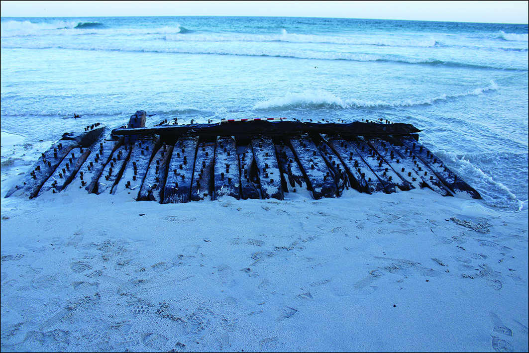
Increased storminess, unusual wind patterns and sand erosion, all linked to climate change, exposed the remains of this ship in 2024 on the coast of Sanday, one of Scotland’s Orkney Islands. Stormy seas also played their part in wrecking the ship in 1788. Collaborative community-led historical and archaeological research have identified it as the Earl of Chatham: a former Royal Navy frigate HMS Hind repurposed and renamed as a whaling ship. As such, it saw active service during the sieges of Louisbourg and Quebec, intended to extend and protect British colonial interests in North America, and as a commercial vessel exploiting the Arctic seas to supply the British industrial revolution’s demand for whale oil. It was built with wood from south and south-west England, which is now being conserved in a freshwater tank at Sanday Heritage Centre. Changes to coastlines, the rates of which are predicted to accelerate in the coming decades, are likely to reveal and threaten many similar heritage sites and their political ecologies in the future. Photograph: Wessex Archaeology, reproduced with kind permission.

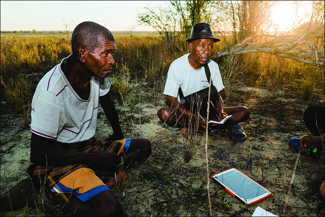
Mikea historian Remisy (left) and Tsiazonera (right), Professor of History at the University of Toliara, Madagascar, conducting an oral history interview at an archaeological site in the Namonte Basin of south-west Madagascar’s Mikea Territories in 2018. The interview formed part of a collaborative project investigating how transitions in livelihoods have intersected with sociopolitical change in the region over the past five centuries. By documenting historical knowledge of mobility, pastoralism and dry-forest foraging, the research seeks to better understand how communities have adapted during periods of environmental and climate change. This conversation offers insight into the deep histories of resilience and flexibility that have shaped life in the Mikea Territories and continue to inform contemporary adaptations. Project details kindly provided by Kristina G. Douglass, Columbia University. Photograph: Garth Cripps/Morombe Archaeological Project.

Archaeology in an age of environmental crisis
![]() We are often told that we live in an age of environmental catastropheFootnote 1. Our knowledge and experiences of a plethora of intertwined phenomena confirm or deny this view: global heating; extreme weather events; wildfire; sea-level rises; flooding; over-exploitation of resources; contamination of land, water and air; soil degradation; habitat destruction; loss of biodiversity; mass extinction of wildlife; human displacement; and climate denial. In response, a broad coalition of archaeologists—not just those studying past ecological transformations and related human dynamics—have sought to realign environmental archaeology with the changing circumstances of the present. Antiquity has hosted a representative share of this discourse, extending from an early call for archaeology to join the ‘Green’ movementFootnote 2, through spelling out the responsibilities of archaeologists and heritage managers in practice and research regarding climate changeFootnote 3, to interrogating key concepts such as ‘sustainable archaeology’ and ‘the Anthropocene’Footnote 4. At the core of this complex debate remain questions around what actions archaeologists should be, and are, taking and whether or not we are doing enough to make a difference to the vulnerable world on which we leave our footprint. Despite all the talk, the definitions, premises and goals of archaeologists in this vast field are varied and even contradictory, while impactful archaeological action is much smaller in scale. Below, I set the scene by reviewing some of the extensive archaeological literature published on this topic, particularly in recent years, before introducing new contributions to the debate published in this issue of Antiquity. I then offer some concluding thoughts on possible future action. I am very grateful to Umberto Albarella, Clio Hall and Valentina Vulpi for commenting on a first draft.
We are often told that we live in an age of environmental catastropheFootnote 1. Our knowledge and experiences of a plethora of intertwined phenomena confirm or deny this view: global heating; extreme weather events; wildfire; sea-level rises; flooding; over-exploitation of resources; contamination of land, water and air; soil degradation; habitat destruction; loss of biodiversity; mass extinction of wildlife; human displacement; and climate denial. In response, a broad coalition of archaeologists—not just those studying past ecological transformations and related human dynamics—have sought to realign environmental archaeology with the changing circumstances of the present. Antiquity has hosted a representative share of this discourse, extending from an early call for archaeology to join the ‘Green’ movementFootnote 2, through spelling out the responsibilities of archaeologists and heritage managers in practice and research regarding climate changeFootnote 3, to interrogating key concepts such as ‘sustainable archaeology’ and ‘the Anthropocene’Footnote 4. At the core of this complex debate remain questions around what actions archaeologists should be, and are, taking and whether or not we are doing enough to make a difference to the vulnerable world on which we leave our footprint. Despite all the talk, the definitions, premises and goals of archaeologists in this vast field are varied and even contradictory, while impactful archaeological action is much smaller in scale. Below, I set the scene by reviewing some of the extensive archaeological literature published on this topic, particularly in recent years, before introducing new contributions to the debate published in this issue of Antiquity. I then offer some concluding thoughts on possible future action. I am very grateful to Umberto Albarella, Clio Hall and Valentina Vulpi for commenting on a first draft.
Taking action
Making a difference
![]() Most archaeologists hope, even believe, that we can make a positive difference, both through individual and collective action. At home and work, many of us habitually reduce our environmental footprint by consuming fewer resources, recycling, investing in renewable energies, using less environmentally harmful materials, and caring for the places we live in. Some of us also join protests, for example, to persuade commercial archaeology organisations and prominent archaeology museums to divest away from major polluters who sponsor their work. Collectively, archaeologists also emphasise—increasingly in publications targeted at other scientific communities—that we can provide unique contributions to interdisciplinary fields such as historical ecology, by deepening people’s understanding of past environmental changes and related human impacts, adding data to improve scientific models of future trajectories, and informing policymakers’ and heritage managers’ planning for sustainable development and adaptation in the face of contemporary environmental challengesFootnote 5. For example, Ariane Burke and colleagues argue that the archaeology of climate change can offer a wealth of contextualised scientific information about past human-climate interactions and strategies and their outcomesFootnote 6. This, they suggest, can provide a means of calibrating large-scale predictive models used by climate scientists and a source of novel hypotheses and narratives around human resilience in the past—both in support of contemporary efforts to respond to climate change.
Most archaeologists hope, even believe, that we can make a positive difference, both through individual and collective action. At home and work, many of us habitually reduce our environmental footprint by consuming fewer resources, recycling, investing in renewable energies, using less environmentally harmful materials, and caring for the places we live in. Some of us also join protests, for example, to persuade commercial archaeology organisations and prominent archaeology museums to divest away from major polluters who sponsor their work. Collectively, archaeologists also emphasise—increasingly in publications targeted at other scientific communities—that we can provide unique contributions to interdisciplinary fields such as historical ecology, by deepening people’s understanding of past environmental changes and related human impacts, adding data to improve scientific models of future trajectories, and informing policymakers’ and heritage managers’ planning for sustainable development and adaptation in the face of contemporary environmental challengesFootnote 5. For example, Ariane Burke and colleagues argue that the archaeology of climate change can offer a wealth of contextualised scientific information about past human-climate interactions and strategies and their outcomesFootnote 6. This, they suggest, can provide a means of calibrating large-scale predictive models used by climate scientists and a source of novel hypotheses and narratives around human resilience in the past—both in support of contemporary efforts to respond to climate change.
The archaeological ambition here is bold and sincere. However, there may be a theoretical price to be paid for a return to macro-scale systems thinking, particularly when accompanied by vague use of terms and concepts. Examples include ‘climate change’, ‘risk’, ‘tipping point’, ‘disaster’, ‘collapse’ and ‘survival’, often featuring human failure, as well as the alternative terminology of ‘persistence’, ‘resilience’, ‘adaptation’, ‘sustainability’ and ‘landesque capital’, more optimistically infused with human agency. Taking one of these concepts, Mette Løvschal argues that ‘resilience’ (understood by Løvschal not only as the ability of a system to remain essentially unchanged in the face of disturbance—as ecologists use the term—but also as the capacity of societies to adapt to major environmental and social transformations) is frequently understood through branches of systems thinkingFootnote 7. These tend to: perpetuate the Western nature/culture dichotomy and emphasise human centrality; work within a framework of positivist approaches characterised by hypothesis testing, quantification and causal modelling; and place excess emphasis on a capitalist model of societal choices and decision-making leading to eventual success or failure. Certainly, assertions about the resilience or adaptability of past societies and their applicability to present-day problems do need to be better defined and more rigorously substantiated by archaeological research to be credible and influential.
Research
![]() A basic requirement for archaeological influence is strategically gathering high-resolution multiproxy data, using an array of scientific methods and with improved chronological controls to reveal ecodynamics over multiple temporal and spatial scales. As various contributions to the archaeological literature have sought to show, these empirical data inform the modelling and interpretation of past environmental changes and their impacts on human societies. For example, using agent-based modelling, Marco Vidal-Cordasco and Abraham Nuevo-López have explored how increasing aridity, rainfall variability, soil erosion, dietary reliance on agriculture and intensity of raiding could have influenced human pressure on cultivable lands, demography, settlement patterns, commercial networks and migrations in the eastern Mediterranean during the Late Bronze Age ‘crisis’ between the thirteenth and eleventh centuries BCE, with droughts emerging as the driving factorFootnote 8. In contrast, Andrew Bauer avoids simply claiming that climate change associated with the onset of droughts during the Little Ice Age of the fourteenth century CE caused selective abandonments of some settlement locales at the site of Maski on the semi-arid Raichur Doab in southern IndiaFootnote 9 (Figure 1). Instead, by considering how environmental disruptions impact people’s lives differently, Bauer argues that it was ultimately the changing social distribution of land-use rights—between agricultural labourers, on the one hand, and temples and their managers, on the other, who encroached on more drought-resistant soils—as well as military conflict and new taxation schemes imposed by the Delhi Sultanate and its successor states that led the most vulnerable farmers to choose to escape these conditions in search of a less precarious future. Data on palaeoecological conditions also underpin the establishment and extension back in time of accurate and appropriate scientific baselines, drawn up to measure where we stand today and to model future trajectories.
A basic requirement for archaeological influence is strategically gathering high-resolution multiproxy data, using an array of scientific methods and with improved chronological controls to reveal ecodynamics over multiple temporal and spatial scales. As various contributions to the archaeological literature have sought to show, these empirical data inform the modelling and interpretation of past environmental changes and their impacts on human societies. For example, using agent-based modelling, Marco Vidal-Cordasco and Abraham Nuevo-López have explored how increasing aridity, rainfall variability, soil erosion, dietary reliance on agriculture and intensity of raiding could have influenced human pressure on cultivable lands, demography, settlement patterns, commercial networks and migrations in the eastern Mediterranean during the Late Bronze Age ‘crisis’ between the thirteenth and eleventh centuries BCE, with droughts emerging as the driving factorFootnote 8. In contrast, Andrew Bauer avoids simply claiming that climate change associated with the onset of droughts during the Little Ice Age of the fourteenth century CE caused selective abandonments of some settlement locales at the site of Maski on the semi-arid Raichur Doab in southern IndiaFootnote 9 (Figure 1). Instead, by considering how environmental disruptions impact people’s lives differently, Bauer argues that it was ultimately the changing social distribution of land-use rights—between agricultural labourers, on the one hand, and temples and their managers, on the other, who encroached on more drought-resistant soils—as well as military conflict and new taxation schemes imposed by the Delhi Sultanate and its successor states that led the most vulnerable farmers to choose to escape these conditions in search of a less precarious future. Data on palaeoecological conditions also underpin the establishment and extension back in time of accurate and appropriate scientific baselines, drawn up to measure where we stand today and to model future trajectories.
The Durgada Gudda outcrop, at the foot of which lies the large multi-period settlement site of Maski, in the semi-arid Raichur District in South India. Photograph: Maski Archaeological Research Project (Johansen & Bauer 2013: fig. 2).

These data are essential when it comes to grounding our interpretations, which extend into the interdisciplinary field of political ecology. Here, scholars argue that human activities within ecological systems can be politically situated and can have enduring consequences that can be studied archaeologicallyFootnote 10 (Frontispiece 1). For example, Poul Holm and colleagues have charted the dramatic increase in lucrative North Atlantic fisheries after 1500 CE, mediated by forces of climate change and market globalisation, which led to a 15-fold increase in the volumes of cod (Gadus morhua) caught, a tripling of supplies to the European fish market, expansion and contraction of fishing communities, and long-term consequences for marine lifeFootnote 11. Integrating political ecology and archaeology can also inform critiques of early archaeological practices and interpretative narratives. For instance, Fernando Galeana has shown how US businessmen, collectors and archaeologists were instrumental in imagining the Mosquita region in eastern Honduras as a wild-frontier zone, waiting to be tamed and exploited, with lost natural and archaeological ‘resources’ such as the legendary ‘White City’ offering opportunities to be marketed as antiquities or as tourist sites, and with scant regard for the rights of Indigenous communities. Caution is, however, needed to avoid imposing our current political preoccupations onto the past at the expense of detailed understanding of ecological processes.
The development of ‘post-humanist’ theories (variously labelled as ‘new materialism’, ‘symmetrical archaeology’, ‘multi-species theory’, etc.) is also challenging excessively anthropocentric perspectives and assumed nature/culture divisions. Instead, such theories encourage us to rethink human/non-human relationships by decentring humans and placing dynamic ‘more-than-human’ entities on a more equal ontological footing, while also recognising the embeddedness of humans in ecosystemsFootnote 12. Alongside this intellectual shift, a few lawyers are—in addition to upholding human rights—also beginning to establish the rights of nature in Colombia and EcuadorFootnote 13. Such thinking has, however, received some push-back. For example, Piraye Hacιgüzeller advocates an Anthropocene archaeology that remains critical of and learns from the ethical and political shortcomings of non-anthropocentric perspectives, with their inherent lack of focus on human-human relations and their largely ahistorical natureFootnote 14.
The validity and utility of the concept of the ‘Anthropocene’ itself has been much debated, including by archaeologistsFootnote 15. The term was first coined by atmospheric chemist Paul Crutzen and biologist Eugene Stoermer—particularly with geologists and ecologists in mind—to define a current geological epoch marked by the major impacts of human activities on the earth and atmosphere at all scalesFootnote 16. Like Hacιgüzeller, Peter Campbell has embraced the idea, even calling for a redefinition of archaeology, to one that encompasses not only the study of the past through material remains but also the entirety of human residue, including immaterial radiation, radio waves and greenhouse gasesFootnote 17. Matt Edgeworth, however, questions the concept, partly because it clumps all humans together while also separating them from other forces bringing about Earth system change, and because, from an archaeological perspective, the Anthropocene does not have a precisely defined date of onsetFootnote 18. This has been variously defined as beginning in the mid-twentieth century (using the radioactive fallout from nuclear weapons tests as a primary stratigraphic marker), or in the Industrial Revolution, or with the development of agricultural economies during prehistory, or the first use of fire by hominins.
Anthropological perspectives that draw on Indigenous ontologies can also benefit archaeological thinking, helping us understand local experiences and ways of knowing the environment and appreciate the environmental adaptations and concerns of present-day communities (Frontispiece 2). Nik Petek-Sargeant and Paul Lane’s work on the archaeologies of weather is pertinent hereFootnote 19. Using a mix of ethnographic, historical and archaeological sources on people’s experiences, philosophies and memories of weather, they highlight the subtleties of responses by Ilchamus communities living in Kenya’s Lake Baringo lowlands to short-term climatic fluctuations and related unpredictable weather since the end of the Little Ice Age (c. 1850 CE).
Applied science
![]() Alongside their research, environmentally sensitive archaeologists argue in publications that it is our responsibility to share lessons from the past about human practices (both successful and unsuccessful) for future ecological and societal benefit in the face of present-day difficulties. While recognising the contribution and potential of modern technologies and developments, and not intending to romanticise the past, Nicole Boivin and Alison Crowther see this as nothing short of “mobilizing the past to shape a better Anthropocene”Footnote 20. The scope of this agenda is expansive. But is it over-optimistic?
Alongside their research, environmentally sensitive archaeologists argue in publications that it is our responsibility to share lessons from the past about human practices (both successful and unsuccessful) for future ecological and societal benefit in the face of present-day difficulties. While recognising the contribution and potential of modern technologies and developments, and not intending to romanticise the past, Nicole Boivin and Alison Crowther see this as nothing short of “mobilizing the past to shape a better Anthropocene”Footnote 20. The scope of this agenda is expansive. But is it over-optimistic?
Archaeologists regularly set their sights on impacting environmental and cultural heritage management decision-makers, strategies and funded actions, both regionally and internationally. A common starting point is to highlight the relevance of palaeoenvironmental, archaeological and historical heritage and research to the United Nation’s Sustainable Development Goals (SDGs) which promote, among other things, strengthening efforts to combat climate change, implementing resource efficiency, using clean energy, strengthening resilience, improving risk-management and adaptation to natural hazards and disasters, safeguarding and restoring the world’s heritage, and promoting sustainable tourismFootnote 21. The scale and diversity of problems are enormous. Jørgen Hollesen, for example, reminds us that, with the threat posed by climate-change processes of extensive damage and loss to cultural heritage sites around the world, archaeologists and heritage managers are being confronted by important yet difficult decisions, including about which sites and ecosystems to monitor, preserve and restore, which to document and excavate in mitigation for their loss, and which to let go of through ‘curated decay’, all of which should ideally be informed by detailed risk assessment and disaster management planningFootnote 22. But climate change is not the only threat. For example, Michael Brennan and colleagues emphasise the urgent global need to identify, assess and mitigate the archaeological and environmental risks posed by the ‘toxic heritage’ of potentially polluting shipwrecks, many dating from the Second World War, containing large volumes of petroleum-based fuel, chemical warfare agents and unexploded ordnance, with the potential to cause serious environmental hazards should the corroding vessels leakFootnote 23 (Figure 2). Archaeologists are similarly working on plastics in the contemporary worldFootnote 24.
The Dixie Arrow, part of a collection of shipwrecks that includes many from the Second World War’s Battle of the Atlantic, now protected at Monitor National Marine Sanctuary, USA. Photograph: Joe Hoyt/US National Oceanic and Atmospheric Administration. CC0 1.0. https://commons.wikimedia.org/wiki/File:MNMS_-_Dixie_Arrow_(27369203044).jpg.

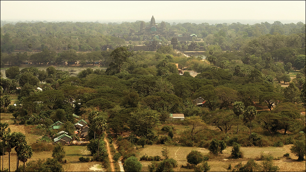
In seeking to inform future policies, archaeologists are not short on bold ideas to tackle challenges ranging from wetland preservation to sustainable agriculture to resilient urban planning. For example, Vernon Scarborough and Christian Isendahl argue that knowledge about sustainable, networked, low-density, agrarian-based urban systems in tropical regions in the ancient past—ranging from the ancient Maya urban centre of Tikal, Guatemala, (c. 700 CE) to the capital city of the Khmer Empire at Angkor Wat, Cambodia (c. ninth to fifteenth centuries CE)—can add to more diversified models for future urban planningFootnote 25 (Figure 3). However, Adam Green and colleagues note: “Governments and policy makers often struggle to see how a specific lesson from the past might interact with policies in the present.”Footnote 26 There can also be structural barriers to using archaeology to address contemporary environmental concerns. Marcy Rockman and Carrie Hritz claim this is the case with the US federal government, which they characterise as having a fragmented approach to managing archaeology and cultural heritage at the national level, rooted in the cultural resources management system established by the National Historic Preservation Act of 1966Footnote 27.
Part of the vast low-density urban area and higher-density ceremonial centre at Angkor Wat, Cambodia, viewed from the air. Photograph: jokertrekker. CC BY 3.0. https://web.archive.org/web/20161023214101/http://www.panoramio.com/photo/61885262.

Others therefore call for archaeology to move away from Western ‘grand narratives’ of global challenges and managed solutionsFootnote 28, towards contributing to problem-solving, meaningful action and small wins on local issues, particularly by investing in one place or region and developing partnerships with local communities and related stakeholders. (This is not a new way of thinking: since 1969, Friends of the Earth have popularised the slogan “Think globally, act locally”Footnote 29.) For example, the Florida Public Archaeology Network’s citizen science initiative, ‘Heritage Monitoring Scouts’, is dedicated to empowering local communities to recognise, document and mitigate the impacts of climate change, including the increased severity of coastal erosion, hurricanes, fires and rain, at threatened archaeological sites throughout the stateFootnote 30. Although some projects are more successful than others, there can be no one-size-fits all approach here, since communities are variable and constantly changingFootnote 31.
Working with Indigenous communities, collaborative archaeological projects are helping to document, protect and revitalise sustainable ancient and ancestral knowledge, technologies, crops and land-stewardship practices, sometimes combined with support for claims to land rights and responsibilities. Although it should be acknowledged that “specific ecological practices … may not easily transfer to modern contexts”Footnote 32, it is also argued that the reintroduction of ancient practices can be particularly appropriate for developing countries, having been tried and tested there for centuries and being cheaper, locally manageable and more sustainable than modern industrial alternativesFootnote 33. In the Americas, projects range from: the rehabilitation of pre-Hispanic water dams by modern-day rural communities under threat from drought and ill-conceived modern reservoirs in the Peruvian tropical AndesFootnote 34; to eco-archaeological research in central coastal California, USA, recording and restoring the ancestral ecological knowledge and stewardship practices of the Amah Mutsun Tribal Band on public and private property, including fire use, and documenting the detrimental impact of successive colonial land use regimesFootnote 35; to zooarchaeological research demonstrating that the Indigenous Tseil-Waututh community occupying the present-day Burrard Inlet in British Colombia, Canada, consistently, preferentially and sustainably fished here for chum salmon (Oncorhynchus keta) for 2500 years, until the introduction of settler colonial fishery practices in the mid-1800sFootnote 36. In India, the results of archaeological and historical research into the history of agriculture and water management have also been used to advocate for the increased capture and control of surface water by local communities, in contrast to their unsustainable reliance on pumped groundwater, through renovation of collective ponds and reservoirsFootnote 37. Exemplars range from the water-management systems of the Indus Valley Tradition (c. 2600–1900 BCE) in north-west India (Figure 4) to the massive tank system associated with the medieval Kakatiya Dynasty (c. 956–1323 CE) in south India. The success of all these cases depends not only on recognising Indigenous communities’ historical experience of environmental variability and adaptation but also on setting realistic, localised scenarios to act on.
Dholavira in Gujarat, India: one of the largest cities of the Indus Valley Tradition (occupied c. 3500–1900 BCE), whose water management network includes a reservoir with steps. Photograph: Lalit Gajjer. CC BY-SA 4.0. https://commons.wikimedia.org/wiki/File:DHOLAVIRA_SITE_(24).jpg.

Environmental archaeologists are also contributing to local restoration ecology projects by highlighting the relevance of their research on baseline ecological conditions and species ranges to contemporary nature recovery agendas. For example, the ‘Rewilding’ project led by Oxford Archaeology aims, with particular reference to Bronze and Iron Age ecologies (c. 2500 BCE–43 CE) in Britain, to contribute to restoring wildlife areas in modern landscapes, to reinstating species that have become locally extinct, to letting natural processes take over, and to encouraging a wide set of people to reconnect with natureFootnote 38. Similarly, in west-central Italy, Meryl Shriver-Rice and colleagues make the case that, by presenting scientific evidence of the cultural relations that existed in the past between humans and a species that has either since gone extinct in the landscape or been classed as harmfully invasive, environmental archaeologists can support conservation biology-led wildlife campaigns to influence public support for the reintroduction of species such as the lynx (Lynx lynx), which used to hold an important place in the region’s Etruscan cultureFootnote 39. Archaeologists, however, also question a minority of conservationists’ promotion of excessive nostalgia about past ecologies and cultures and their desire to turn the clock back to imagined pristine, ‘native’, ‘humanless’ conditionsFootnote 40.
Activism
![]() All this may still not be enough to make a significant difference, given the scale of the environmental pressures we face. Some reflexive and ethical archaeologists have consequently published calls for more radical, ecopolitical thought and action. Shumon Hussain and Felix Riede, for example, call for the boundaries between activism, advocacy and academic to be re-negotiated carefully, to promote climate action and counter the emergent linkage between climate scepticism and right-wing nationalismFootnote 41. Other archaeologists are committed to ‘environmental justice’. They are documenting the historical connections between environmental degradation, European colonialism and ongoing socioeconomic injustices and inequalities, especially impacting communities in the Global South as well as Indigenous and diaspora communities elsewhere. For example, Kristina Douglass and Jago Cooper argue that the legacies of past colonial practices, which disenfranchised autonomous resource use, threatened intergenerational transfer of ecological knowledge, introduced non-native plants and animals, and reshaped land- and seascapes, underly vulnerabilities to present and future climate change among Caribbean and south-western Indian Ocean communities, on islands such as MauritiusFootnote 42. Katherine Parker and colleagues have also actively set out to undertake research on the overlooked archaeological heritage of Maroons, enslaved canal-company labourers and disenfranchised Native Americans who sought refuge between 1630 and 1865 CE in the Great Dismal Swamp, which is now a National Wildlife Reserve on the border of Virginia and North Carolina, USA (Figure 5). The researchers aim to determine the archaeological potential of the area, model the effects of sea-level rise and storm surge, discuss heritage preservation priorities, and tackle the ‘structural violence’ suffered by its marginalised communitiesFootnote 43. Other archaeologists engaged in Green politics have also actively challenged the attitudes and practices of their employers, including those involved in the often environmentally damaging context of developer-funded archaeology.
All this may still not be enough to make a significant difference, given the scale of the environmental pressures we face. Some reflexive and ethical archaeologists have consequently published calls for more radical, ecopolitical thought and action. Shumon Hussain and Felix Riede, for example, call for the boundaries between activism, advocacy and academic to be re-negotiated carefully, to promote climate action and counter the emergent linkage between climate scepticism and right-wing nationalismFootnote 41. Other archaeologists are committed to ‘environmental justice’. They are documenting the historical connections between environmental degradation, European colonialism and ongoing socioeconomic injustices and inequalities, especially impacting communities in the Global South as well as Indigenous and diaspora communities elsewhere. For example, Kristina Douglass and Jago Cooper argue that the legacies of past colonial practices, which disenfranchised autonomous resource use, threatened intergenerational transfer of ecological knowledge, introduced non-native plants and animals, and reshaped land- and seascapes, underly vulnerabilities to present and future climate change among Caribbean and south-western Indian Ocean communities, on islands such as MauritiusFootnote 42. Katherine Parker and colleagues have also actively set out to undertake research on the overlooked archaeological heritage of Maroons, enslaved canal-company labourers and disenfranchised Native Americans who sought refuge between 1630 and 1865 CE in the Great Dismal Swamp, which is now a National Wildlife Reserve on the border of Virginia and North Carolina, USA (Figure 5). The researchers aim to determine the archaeological potential of the area, model the effects of sea-level rise and storm surge, discuss heritage preservation priorities, and tackle the ‘structural violence’ suffered by its marginalised communitiesFootnote 43. Other archaeologists engaged in Green politics have also actively challenged the attitudes and practices of their employers, including those involved in the often environmentally damaging context of developer-funded archaeology.
Thomas Moran (1862). Slave hunt, Dismal Swamp, Virginia. Oil on canvas. Philbrook Museum of Art. Public domain. https://commons.wikimedia.org/wiki/File:Slave_Hunt,_Dismal_Swamp,_Virginia_by_Thomas_Moran.JPG.

In contrast, Þóra Pétursdóttir and Tim Flohr Sørensen provocatively question the way that archaeological responses to contemporary environmental challenges are widely expected to align with an established mode of conduct, political stance and genre. This, they suggest, is dominated by a specific notion of activism, responsibility and ethics that calls for urgent, scientific, strategic solutions, action and impact. Alongside these actions, they argue that there should be room for slower, undecided, speculative and poetic responses that help us think more closely about the vulnerable things we are concerned about, ranging from ruined buildings to nuclear-waste repositories, without first assuming we know all about them and what to do with themFootnote 44.
Debating contemporary environmental dilemmas in Antiquity
![]() In the current issue of Antiquity, four articles deepen and extend debate on the issues reviewed above. They also reflect the diversity of perspectives and approaches currently adopted by archaeologists in relation to our changing world.
In the current issue of Antiquity, four articles deepen and extend debate on the issues reviewed above. They also reflect the diversity of perspectives and approaches currently adopted by archaeologists in relation to our changing world.
Neal Payne and colleagues present ‘Fenscapes’ in our Project GalleryFootnote 45. This project is synthesising multiproxy data on the landscape archaeology, palaeoecology and environmental archaeology of the Fens of eastern England from around 6000 years ago to the present. A secondary aim is to highlight the importance of these data in underpinning decision-making on cultural and environmental heritage preservation, both regionally and in similarly sensitive lowland wetlands elsewhere.
Related to this, Benjamin Gearey and colleaguesFootnote 46 argue that archaeological advocacy needs to be louder and clearer, to persuade European policymakers to treat the preservation of the deteriorating archaeological heritage of peatlands as integral rather than an afterthought in climate-change mitigation and land-use planning. More specifically, they call on official bodies to explicitly include archaeology in peatland rehabilitation programmes. They also briefly mention enhancing public awareness and engagement.
In contrast, in their debate article, Matthew Davies and Samuel Lunn-RockliffeFootnote 47 argue that archaeologists seeking to impact policymaking on global socioecological challenges must take a more critical attitude towards current, top-down, expert-led policy frameworks, including the United Nation’s SGDs, and rethink their assertion that archaeology’s relevance lies in bringing lessons from the past. Instead, they advocate combining the creation of robust scientific datasets and models with the more transdisciplinary approaches of contemporary archaeology, historical ecology and applied archaeology that work back from present crises to understand how we got here. They therefore recommend inviting local communities, policymakers and non-governmental organisations to co-produce research, designed to generate new forms of knowledge, policy impact and action. In response to the article, Christian IsendahlFootnote 48 supports this approach, particularly because it contributes to reframing archaeology from “strictly looking at the past to doing so for the good of improving the present and future” (p.219). Sarah KerrFootnote 49 also agrees but advises that we implement the approach of Davies and Lunn-Rockcliffe “with a firmer focus on local communities rather than policymakers” (p.221), avoiding the assumption that “the burden of policymaking related to global challenges lies with archaeologists” (p.222).
Anna CollarFootnote 50 takes a step further in this direction, without mention of policymakers. She argues that archaeologists must learn from contemporary rewilding projects, animate Indigenous worldviews and ecosystems within which humans are embedded to enrich our impoverished imagination of the abundant biodiversity of past worlds.
Concluding thoughts
![]() These days, few archaeologists are catastrophists, even though we may oscillate between anxiety, (in)action and hope as to the future health of our planet and our capacity to cope with inevitable changeFootnote 51. Many, indeed, are optimists, arguing that archaeological data and insights can make a difference. This archaeological ambition and rhetoric have at times been exaggerated and largely academic, in claiming that archaeologists and our profound datasets, understanding and strategic thinking can help save the planet, in alliance with other superheroes of science and the humanities, policymakers and communities. Indeed, the goals of archaeology in this arena are insufficiently clear. Given that, today, some ecological states are no longer reversible, we cannot only seek to preserve a world that previously existed or that we are now used to—we have to present a clearer vision of the world we want to live in. Nevertheless, individually and collectively, we can be and are making a positive contribution towards shaping a better Anthropocene by deepening and sharing our research into past and present ecodynamics, lobbying policymakers and organisations to divest from major polluters and invest in sustainable strategies and practices informed by past successes and failings, partnering with a diversity of stakeholders in local initiatives, and doing our bit to tread more lightly on the earth at work and at home.
These days, few archaeologists are catastrophists, even though we may oscillate between anxiety, (in)action and hope as to the future health of our planet and our capacity to cope with inevitable changeFootnote 51. Many, indeed, are optimists, arguing that archaeological data and insights can make a difference. This archaeological ambition and rhetoric have at times been exaggerated and largely academic, in claiming that archaeologists and our profound datasets, understanding and strategic thinking can help save the planet, in alliance with other superheroes of science and the humanities, policymakers and communities. Indeed, the goals of archaeology in this arena are insufficiently clear. Given that, today, some ecological states are no longer reversible, we cannot only seek to preserve a world that previously existed or that we are now used to—we have to present a clearer vision of the world we want to live in. Nevertheless, individually and collectively, we can be and are making a positive contribution towards shaping a better Anthropocene by deepening and sharing our research into past and present ecodynamics, lobbying policymakers and organisations to divest from major polluters and invest in sustainable strategies and practices informed by past successes and failings, partnering with a diversity of stakeholders in local initiatives, and doing our bit to tread more lightly on the earth at work and at home.


.jpg)
.jpg)