


Introduction
The county of Mariwan, located in the western region of Iran, lies on the eastern flank of the chaîne magistrale of the Zagros Mountains at 35°32′0″N, 46°10′0″E, with an elevation of 1286m above sea level (Figure 1). It occupies a critical position as a node on an important historical exchange route traversing the mountain range, connecting the Iranian highlands with the Mesopotamian lowlands (Asiabani et al. Reference Asiabani, Masoumian and Janoscha Kreppnerin press).
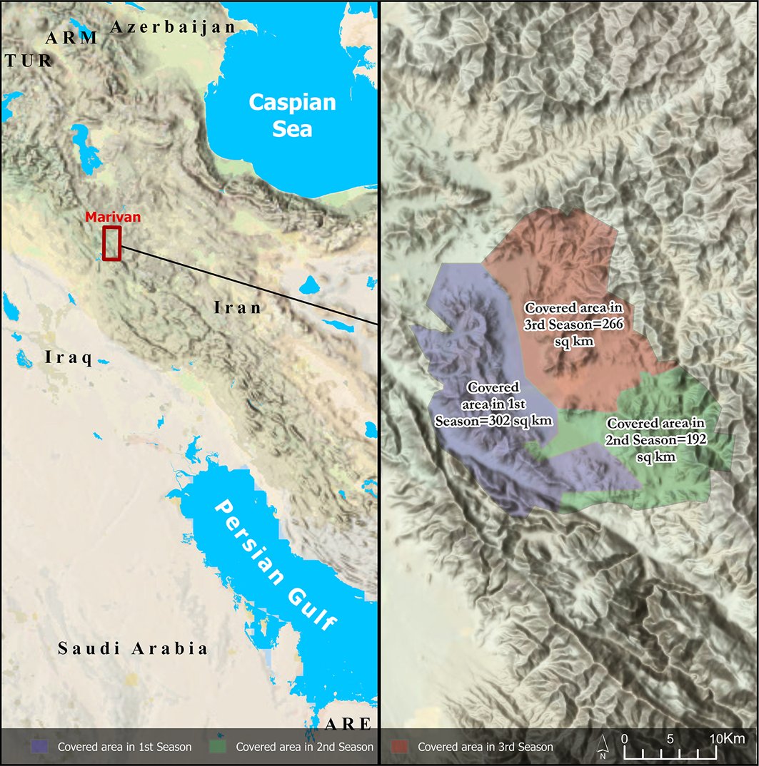
Location of the Mariwan region and the area covered by the survey (figure by Samran Asiabani).

Figure 1 Long description
The map displays the geographic location of the Mariwan region in western Iran, situated on the eastern side of the Zagros Mountains. The map highlights three distinct areas covered by a survey, each marked with different colors: purple for the first season covering 302 square kilometers, green for the second season covering 192 square kilometers, and brown for the third season covering 266 square kilometers. The map also includes surrounding countries such as Azerbaijan, Turkey, Iraq, and Saudi Arabia, as well as the Caspian Sea and the Persian Gulf. The Mariwan region is marked with a red box, indicating its specific location within Iran.
Spanning an area of 2193.4km2, which accounts for approximately 7.77 per cent of Kurdistan Province, Mariwan county is divided into two main zones: the western area, part of the Zagros fold-thrust belt characterised by the Bistoon-Shahoo limestone karst, and the eastern, southern and northern areas, which belong to the Sanandaj-Sirjan magmatic-metamorphic zone. These contrasting zones are bridged by the Siyanaw Valley, a feature that traverses the county’s varied topography (Hariri & Masoumian Reference Hariri, Masoumian, Mosalla and Mortezaei2025).
Due to its geographically strategic location, favourable climate and proximity to ancient civilisations in Western Asia, the Mariwan region has been a significant settlement area throughout prehistoric, historic and Islamic periods. As a key route linking the Iranian Plateau and Mesopotamia, it has historically facilitated interaction and exchange. These factors make the Mariwan region essential for understanding cultural transformation, settlement development and sociopolitical history in western Iran and the Iran-Mesopotamia relationship over millennia.
Archaeological survey in the plain of Mariwan and nearby valleys remains limited. Previous fieldwork has primarily concentrated on key sites near the city of Mariwan. The Mariwan Archaeological Survey (MAS) (2021–2024) is the first systematic, multiseason, county-wide survey in Mariwan. It differs from earlier efforts that focused on site-specific reports or partial-area reconnaissance (e.g. Azizi Reference Azizi2001; Mohammadifar & Motarjem Reference Mohammadifar and Motarjem2002; Dadaneh et al. Reference Dadaneh, Ghasrian, Colantoni and Skuldbøl2019).
Co-directed by Mohammad Masoumian and Nemat Hariri, the MAS has completed three seasons of survey covering 760km2 or 35 per cent of the area of Mariwan administrative district, and has documented 603 archaeological sites. The MAS project investigates the settlement history of the Mariwan region, using a unified recording protocol, ceramic coding and geospatial mapping that have not previously been published at this scale. The project aims to explain diverse cultural and sociopolitical developments of the region by exploring the resilience and socioeconomic robustness of polities and societies of the Mariwan region throughout history.
Methods
The absence of consistent studies in the Mariwan region motivated us to launch a comprehensive project to not only fill the gaps and complete the county’s archaeological map, but also to investigate difficult-to-access sectors, including mountainous regions and the Iran–Iraq border. Three survey seasons were supported by thorough pre-field preparation and background research. Remote-sensing techniques, including analysis of CORONA and KH-9 high-resolution aerial imagery and elevation data, guided the design of a controlled-exclusive ground survey method. This approach allowed a focus on high-priority areas while excluding limited, impassable or rigid terrains; the acquisition of local knowledge confirmed that these areas were unlikely to contain sites of archaeological interest. This strategy allowed efficient resource allocation while maintaining comprehensive coverage.
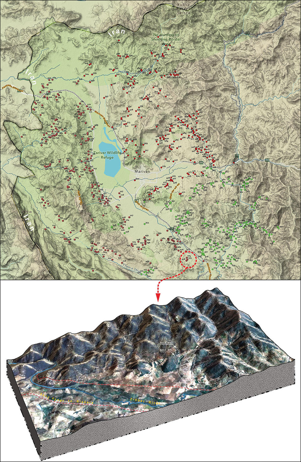
The survey area was systematically divided into transects, spaced approximately 20m apart, which surveyors walked to ensure even coverage. To enhance precision and ensure representative sampling when encountering archaeological features, the region was further divided into smaller units. Data collection focused on selected units based on artefact scatters, ensuring a targeted yet comprehensive approach. These scatters were documented using QField, which was instrumental in facilitating mobile geographic information systems integration, enabling real-time data collection and spatial visualisation directly in the field (Figure 2).
Map illustrating the subdivision of areas into smaller sections, factoring in size and topographical features (figure by Samran Asiabani).

Figure 2 Long description
The map illustrates the county of Mariwan, located in the western region of Iran, situated on the eastern flank of the chane magistrale of the Zagros Mountains. The map is centered at coordinates 35320N, 46100E, with an elevation of 1286 meters above sea level. It highlights the subdivision of areas into smaller sections based on size and topographical features. The map also shows the critical position of Mariwan as a node on an important historical exchange route that traverses the mountain range, connecting the Iranian highlands with the Mesopotamian lowlands. Various markers and symbols are used to indicate different topographical and geographical features within the county.
After individually documenting scatters of archaeological features and delineating their extents as polygons with assigned collection IDs, the determination of site boundaries was conducted through systematic field assessment. This involved walking the area containing the features and using QField to mark key points around the perimeter. These points were used to generate a polygon representing the site extent, ensuring precise and consistent spatial definition.
Findings
A total of 603 sites were identified (Figure 1), including 19 sites indicating continuous occupation from the Middle Palaeolithic to the Epipalaeolithic (c. 100 000–10 000 BC) (Figure 3). A single Neolithic (7500–5000 BC) site was also found, while identification of 35 Chalcolithic (5000–3200 BC) sites indicates the region’s significance during this period, although Early Chalcolithic artefacts were absent. Ceramic analysis suggests Mariwan was influenced by northern and central Zagros cultures, with increased settlement and strengthened links to northern Mesopotamia in later Chalcolithic phases (Figure 4).
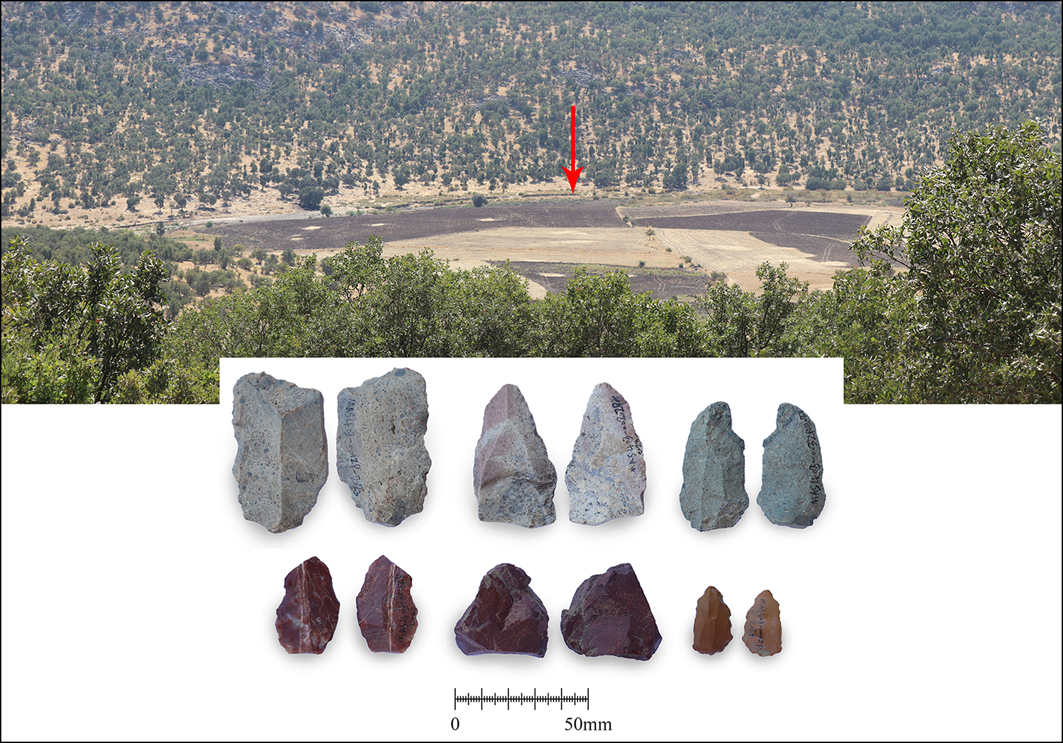
View of a Palaeolithic open-air site (MAS 403) and the lithics related to this site (photographs by Amar Tazik & Hamzah Mohammadpour).

Figure 3 Long description
The image features a landscape view of a Palaeolithic open-air site, identified as MAS 403, with a red arrow pointing to a specific location. Below the landscape, there are various lithic tools arranged in two rows. The top row contains six larger stone tools, while the bottom row displays six smaller stone tools. A scale bar at the bottom indicates measurements in millimeters.
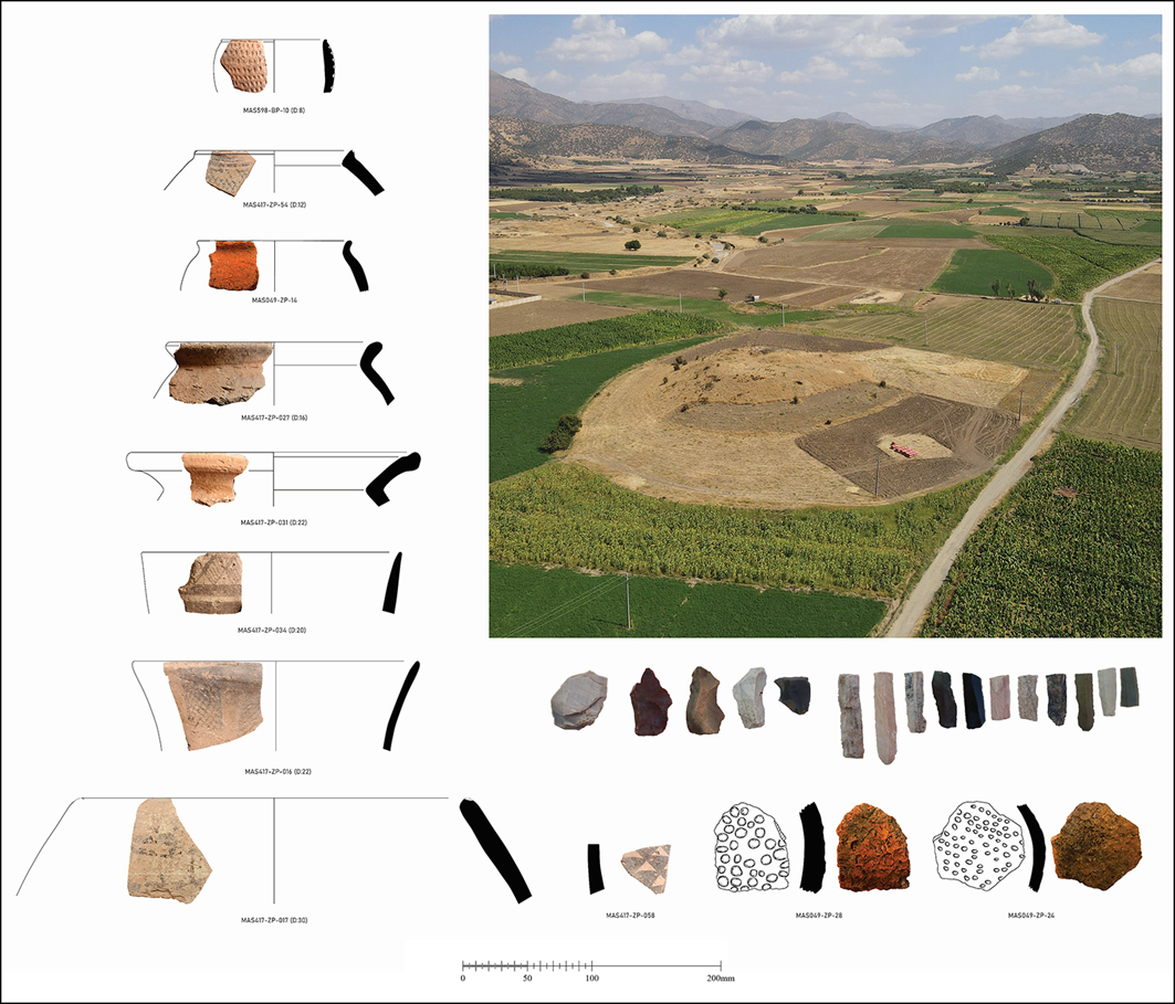
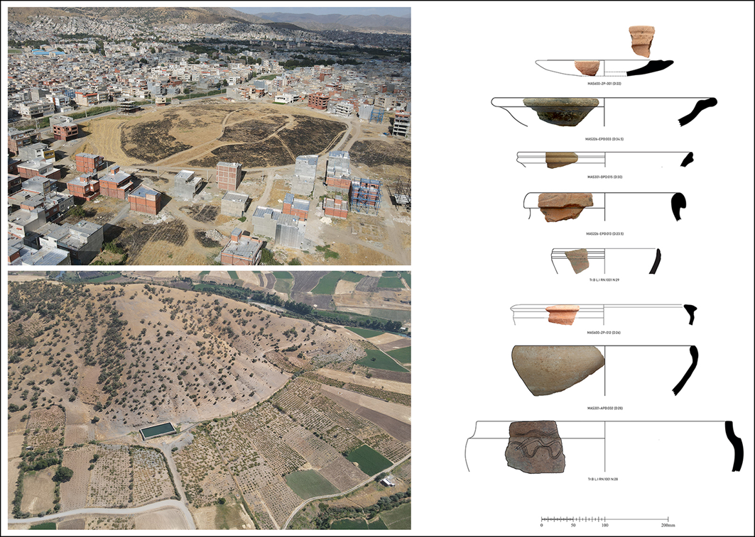
Tepe Qnaran (Kangaran), a Chalcolithic site, and samples of Chalcolithic pottery sherds found in the Mariwan Region (drawings by Masoumeh Bayazidi & Kazhal Jahangiri; figure by Hosain Faqihzadeh).

Figure 4 Long description
The image features an aerial view of Tepe Qnaran, a Chalcolithic site located in the Mariwan Region. The site is surrounded by a landscape of cultivated fields and distant mountains. To the left, there are various pottery sherds displayed, each with unique shapes and patterns, illustrating the diversity of Chalcolithic pottery found at the site. The pottery sherds are accompanied by line drawings that highlight their distinct features.
Only 12 Bronze Age (3200–1250 BC) sites were found, possibly due to environmental or political factors. However, the Iron Age (1250–550 BC) presence is strong, with 117 sites, showing ties in ceramic techniques to sites such as Tepe Rabat (Masoumian et al. Reference Masoumian2025: fig. 2), Ziwiyeh (Mot’amedi Reference Mot’amedi1997) and Godin Tepe (Gopnik & Rothman Reference Gopnik and Rothman2011) (Figure 5).
The identified Iron Age sites of Tepe Kalin Kawa (top left) and Ambardeh (bottom left) and a sample of Iron Age ceramics (drawings by Mojgan Seif Panahi, Masoumeh Bayazidi & Kazhal Jahangiri; figure by Hosain Faqihzadeh).

Figure 5 Long description
The image features two photos and one illustration. The top left photo captures Tepe Kalin Kawa, an Iron Age site near the city of Mariwan. The bottom left photo shows Ambardeh, another Iron Age site in the same region. The right side of the image presents an illustration of a sample of Iron Age ceramics, drawn by Mojgan Seif Panahi, Masoumeh Bayazidi, and Kazhal Jahangiri, with the figure created by Hosain Faqihzadeh. The illustration includes detailed drawings of various ceramic pieces, each labeled with specific identifiers.
For the historical periods (Achaemenid to Sassanian) (550 BC–AD 651), 202 sites, including jar-burial cemeteries, hint at long-standing burial traditions (Figure 6). Islamic-period (AD 651–1900) sites are most numerous at 225, featuring cemeteries and fortified structures, with ceramics resembling earlier types but lacking typical glazed examples.
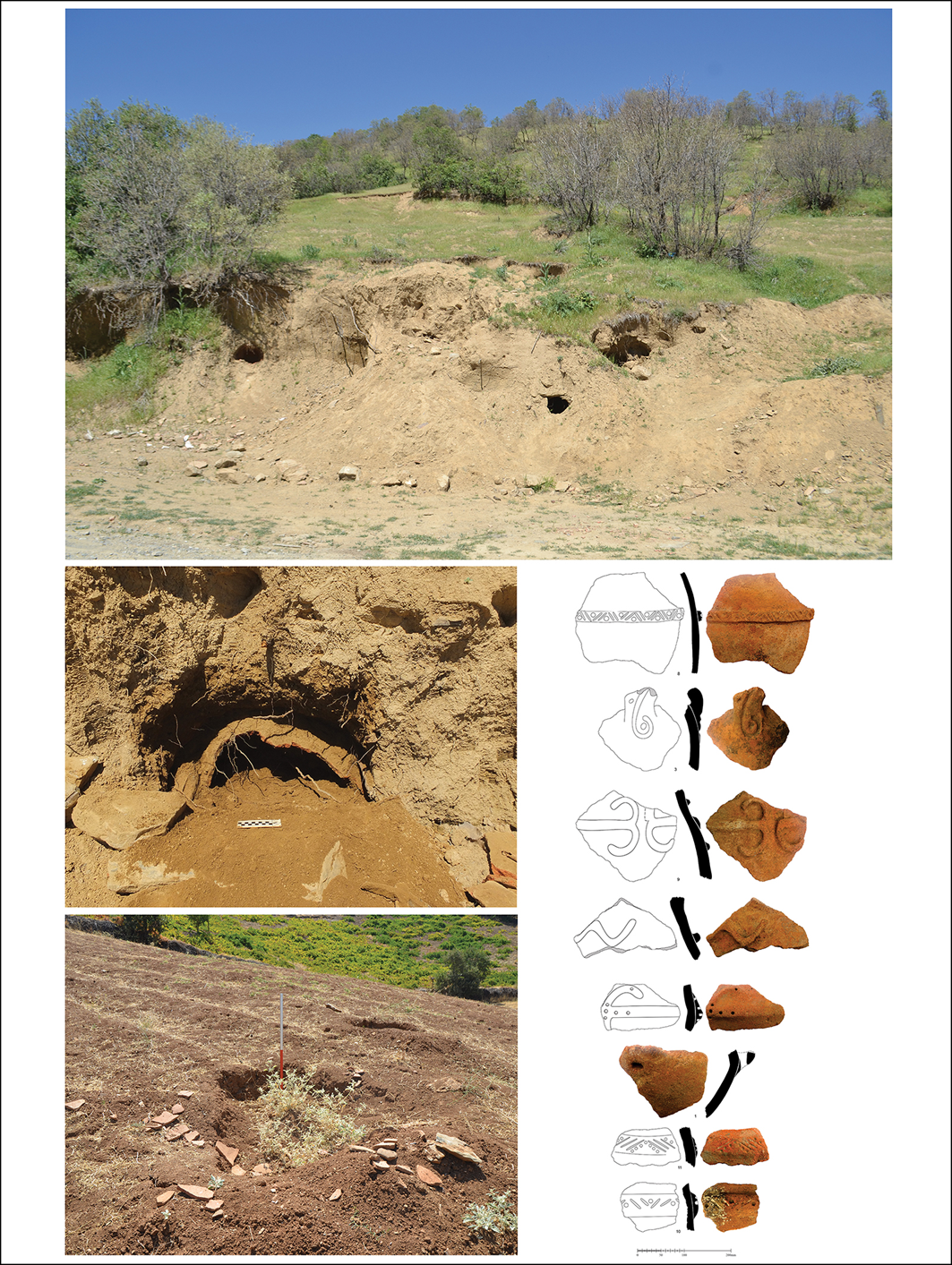
Jar burial cemeteries identified by MAS dating from the Iron Age to the late Sassanid period (drawings by Masoumeh Bayazidi; figure by Mohammad Masoumian & Hamzeh Mohammadpour).

Figure 6 Long description
The top photo shows an eroded landscape with visible holes and artifacts scattered around, likely from an archaeological site. The middle photo provides a closer view of one of the holes, revealing more details of the excavation. The bottom photo focuses on another section of the site, showing a small excavation area with a measuring tape for scale. The illustration on the right displays various pottery shards with corresponding line drawings, highlighting their shapes and designs.
Discussion and conclusion
The findings of the MAS underscore the archaeological richness of this strategically situated region, revealing continuous occupation from the Palaeolithic to the Islamic period. This survey provides critical data that reshape our understanding of the region’s role as both a bridge of cultural exchange and a zone of possible cultural resilience and isolation at different historical junctures.
Middle, Upper and Epipalaeolithic lithic artefacts, Chalcolithic ceramics and Iron Age fortresses highlight Mariwan’s dynamic interactions with neighbouring regions such as Mesopotamia and the broader Zagros area. Conversely, the low density of Bronze Age sites hints at potential sociopolitical or environmental factors influencing settlement patterns, which require further investigation.
Despite the impressive breadth of findings, the lack of absolute dating limits the chronological precision of our interpretation of survey material. Moreover, recent land-use transformations—such as orchard planting, greenhouse development and fencing—have constrained survey visibility in certain parts of the plain, particularly affecting the detection of low-profile sites from earlier periods. This interplay between modern surface conditions and deep-time settlement dynamics is a central focus of our ongoing work.
Nonetheless, the survey’s innovative methods and focus on previously underexplored areas have significantly advanced the archaeological map of western Iran. By bridging knowledge gaps in settlement distribution and cultural transitions, the MAS project not only enhances our understanding of Mariwan’s historical significance but also sets a methodological benchmark for future surveys in the Zagros region. The survey reaffirms Mariwan’s importance as a focal point for studying the complex interplay of local and regional development across millennia.
Acknowledgements
We gratefully acknowledge the support of the Iranian Center for Archaeological Research and the Research Institute of Cultural Heritage and Tourism.
Funding statement
Sponsorship was provided by the Kurdistan Cultural Heritage, Tourism and Handicrafts Directorate, the University of Tehran and the Iran National Science Foundation (Grant no. 4015286).
Author contributions: using CRediT categories
Mohammad Masoumian: Conceptualization-Equal, Data curation-Equal, Funding acquisition-Equal, Methodology-Equal, Project administration-Equal, Supervision-Equal. Nemat Hariri: Conceptualization-Equal, Data curation-Equal, Funding acquisition-Equal, Methodology-Equal, Project administration-Equal, Supervision-Equal. Tim Boaz Bruun Skuldbøl: Writing - original draft-Supporting, Writing - review & editing-Equal. Steve Renette: Writing - original draft-Equal, Writing - review & editing-Equal. Samran Asiabani: Conceptualization-Equal, Data curation-Equal, Funding acquisition-Equal, Methodology-Equal, Project administration-Equal, Supervision-Equal. Fateh Zarefar: Methodology-Equal, Resources-Equal, Software-Equal. Mojgan Seif Panahi: Funding acquisition-Equal, Project administration-Equal, Writing - review & editing-Equal. Hamzeh Mohammadpour: Data curation-Equal, Methodology-Equal, Writing - original draft-Equal. Amar Tazik: Data curation-Equal, Software-Equal, Writing - original draft-Equal. Ali Behnia: Funding acquisition-Equal, Methodology-Equal, Writing - original draft-Equal. Michael Brown: CRediT contribution not specified. Florian Janoscha Kreppner: Data curation-Equal, Methodology-Equal, Writing - original draft-Equal.

 Open access