




Introduction
Climatic and environmental change are increasingly framed as critical topics for archaeological research and practice in the 21st century (e.g. Burke et al. Reference Burke, Peros, Wren, Pausata, Riel-Salvatore, De Vernal, Kageyama and Boisard2021; Kintigh et al. Reference Kintigh, Altschul, Beaudry, Drennan, Kinzig, Kohler, Limp, Maschner, Michener, Pauketat, Peregrine, Sabloff, Wilkinson, Wright and Wright2014). It is intuitive to link much of this interest to presentist concerns about global warming, biodiversity loss and the unsettling creation of precarious norms of living in the context of recent unprecedented levels of global inequality and planetary crisis (e.g. Masco Reference Masco2010). Pre-modern landscapes are persistently acknowledged as key elements, or at least relevant background, to this unfolding story. Many studies of past environmental change now share a contemporary doomist concern for collapse (Middleton Reference Middleton2017; see, e.g., Cline Reference Cline2014; Harper Reference Harper2017). Although archaeologists have been sounding the alarm about a return to environmental determinism, it has become a matter of pressing concern given the swelling interest in, and funding for, grand histories of crisis in climate–society systems (Arponen et al. Reference Arponen, Dörfler, Feeser, Grimm, Groß, Hinz, Knitter, Müller-Scheeßel and Ott2019; Degroot et al. Reference Degroot, Anchukaitis, Bauch, Burnham, Carnegy, Cui, de Luna, Guzowski, Hambrecht, Huhtamaa, Izdebski, Kleemann, Moesswilde, Neupane, Newfield, Pei, Xoplaki and Zappia2021; Hulme Reference Hulme2011). Something like Diamond’s (Reference Diamond2005) Collapse did not single-handedly elevate the natural environment as the external prime mover of human history, but similarly determinist framings have been influential in more recent narratives – drawn from archaeological material – of humans fighting against or succumbing to environmental stress.
Archaeologists rightly caution against attempts to reduce history to a series of reactions to external forces. They have pointed to rich, cross-cultural records that reveal how humans have always engaged with, shaped and been shaped by the non-human worlds around them, in often messy and uneven ways (see recently Gaggioli and Hunter Reference Gaggioli and Hunter2025). But in politically charged debates about a geological ‘age of man’ – Anthropocene – a key area of research now seeks to ask how humans in the past coped with climate and absorbed the kinds of shocks posed by abruptly changing environments (e.g. Degroot Reference Degroot2018; Degroot et al. Reference Degroot, Anchukaitis, Bauch, Burnham, Carnegy, Cui, de Luna, Guzowski, Hambrecht, Huhtamaa, Izdebski, Kleemann, Moesswilde, Neupane, Newfield, Pei, Xoplaki and Zappia2021; Erdkamp et al. Reference Erdkamp, Manning and Verboven2021). A growing number of scholars have turned to hypothesizing, testing and arguing for the long history of such adaptive mechanisms and strategies, backed not only by the availability of more abundant and more highly resolved paleoenvironmental data, but also by an emerging consensus on the entanglement of ‘human’ and ‘natural’ history (Chakrabarty Reference Chakrabarty2009). Yet while many try to distance their work from the Diamond-esque resurfacing of determinism, they have increasingly embraced forms of systems thinking and scientism that characterized archaeological thought of the mid-20th century, moving from concepts like behavioural adaptation to an updated vocabulary: resilience, sustainability, vulnerability.
‘Resilience’ is alluring to many fields – from archaeology and developmental psychology to urban planning and policy – because it is conceptually capacious and can offer alternatives to overly catastrophist visions of societal transformation (e.g. Løvschal Reference Løvschal2022; Tierney Reference Tierney2015). Originating in ecosystem science, and as it is used in archaeology, resilience refers to the capacity of a socioecological system to absorb disturbance and reorganize while undergoing change; such changes to a system can be modelled in terms of the adaptive cycle, which describes four phases of predictable (growth and conservation) or more unpredictable (release and reorganization) dynamics (Walker et al. Reference Walker, Holling, Carpenter and Kinzig2004). Instead of linear trajectories of growth or decline, societal change can be analysed by describing and modelling these repeating and looping phases (Redman Reference Redman2005, Reference Redman2014). Often, scholars use these concepts to describe how systems could withstand disturbance or maintain structural coherence in the face of challenging conditions (Adger Reference Adger2000; Gunderson et al. Reference Gunderson and C.2009). Resilience is indeed often directly contrasted with societal collapse, a topic of archaeological interest since the 1980s (McAnany and Yoffee Reference McAnany and Yoffee2010; Yasur-Landau et al. Reference Yasur-Landau, Gambash and Levy2024; Middleton Reference Middleton2017). In addition to this dichotomous pairing of collapse and resilience, the use of the theory in archaeology is often made explicitly relevant to our own ‘contemporary issues’ of planetary crisis (Redman Reference Redman2005, 70).
Its status as a buzzword notwithstanding, resilience thinking has gained noticeable traction in Mediterranean archaeology, which seems instinctive given the post-millennial scholarly consensus on the basin’s exceptional traits of climate, vegetation and ecological fragmentation, which produced typical adaptive responses to risk and precarity (especially Horden and Purcell Reference Horden and Purcell2000, building on Braudel Reference Braudel1972). While the subfield of landscape archaeology in this region is methodologically diverse (see recently Knodell et al. Reference Knodell, Wilkinson, Leppard and Orengo2023), the concept ostensibly works well with existing theories of Mediterranean landscapes as constructions of human action and natural processes (e.g. Walsh Reference Walsh2014; Weiberg et al. Reference Weiberg, Kouli, Katsianis, Woodbridge, Bonnier, Engel, Finné, Fyfe, Maniatis, Palmisano, Panajiotidis, Roberts and Shennan2019). By invoking long-term studies of social and environmental history such as the Braudelian longue durée, archaeologists advocate examining dynamics of resilience that can nuance linear rise-and-fall narratives of ancient states (e.g. Yasur-Landau et al. Reference Yasur-Landau, Gambash and Levy2024).
The integration of resilience thinking with the methodologies of Mediterranean survey archaeology, however, and the expanding use of systems thinking warrant further scrutiny. My concerns relate to what extent claims about the methodological or heuristic utility of resilience are masking or creating new problems in studies of past human–environment relationships. In this paper, I argue that two clusters of problems need assessment, one interpretative and one methodological. First: the scientific language of resilience essentializes past communities and obfuscates subjects of analysis, all while reducing mechanisms of change to adaptation to external stressors. Second: the typically coarse temporal resolution of survey datasets, even in the notoriously high-intensity projects of the Mediterranean, are challenging proxies for multitemporal phases of adaptation (e.g. Wilkinson Reference Wilkinson, Athanassopoulos and Wandsnider2004). Basing analyses on survey records contributes to a reification of evidentiary patterns of (dis)continuity. Resilience thinking alone is therefore limited in its ability to explain past landscape changes (Marston Reference Marston2025), and many who employ it acknowledge its weaknesses in capturing causal mechanics (e.g. Daems and Vandam Reference Daems and Vandam2024).
After a first section that reviews how Mediterranean landscape archaeologists have taken up resilience theory, I emphasize three elements of these interpretative and methodological problems: the essentializing of past community practices, the methodological mismatch between survey data and resilience theory and the political stakes of connecting past adaptations to our present crisis. As with any trending term that has found purchase inside and outside academic research, there is already significant critique from social scientists, humanists and other archaeologists, which I build upon (e.g. Bauer Reference Bauer2025; Cameron Reference Cameron2012; March and Swyngedouw Reference March, Swyngedouw, Ruiz-Mallén, March and Satorras2022; Marston Reference Marston2025; Mikulewicz Reference Mikulewicz2019; Olsson et al. Reference Olsson, Jerneck, Thoren, Persson and O’Byrne2015; Vardy and Smith Reference Vardy and Smith2017). To move beyond some of these ahistorical and apolitical limitations, and while still sympathetic to archaeological studies of persistence and adaptation, in a third section I advocate more work drawn from political ecology on landscape time and temporality, social difference and liveable practices at smaller scales. A case study from Iron Age Cyprus briefly illustrates these critiques. At stake, I think, are not just implications for the study of pre-modern landscapes and settlement pattern studies but also opportunities to address ethical concerns about the analogizing of past and present resilience to make claims about our own futures.
Resilience thinking in landscape archaeology and its discontents
As in other fields, archaeologists use the term ‘resilience’ in multiple analytical and heuristic registers. Jacobson’s (Reference Jacobson2022) recent and helpful bibliometric review, for example, shows that for many scholars, resilience remains a metaphor – conceived loosely as the ability of a system, such as a society or state, to bounce back after some stressor and to recover with the capacity for adaptability. Generalized metaphorical use of the term as a heuristic, for instance, features in the binary language of ‘fragility and resilience’ in broad takes on state collapse (e.g. Harper Reference Harper2017). Others invoke a more psychological connotation: the ability of communities to preserve cultural traits while adapting to adversity (e.g. Hoernes Reference Hoernes2022, 299). In its perhaps simplest form, a ‘resilient action’ could denote any modification in the face of disturbances, for example using an abandoned building as an animal pen instead of rebuilding (e.g. Munro Reference Munro2023, 17). Archaeologists who implement a more formal framework of resilience theory deriving from ecosystem science, developed by Holling (Reference Holling1973), turn to the work of scholars like Redman (Reference Redman2005, Reference Redman2014; Redman and Kinzig Reference Redman and Kinzig2003) to explicate the interplay between change and stability in past socioecological systems.
This formal theorization assumes a set of principles from complexity science about how coupled human–natural systems persist and respond to perturbations through adaptive cycles (Marston Reference Marston2025). Resilience thinking involves modelling the potential trajectories and self-organizing interactions between change and adaptation among multiple nested scales, or ‘panarchy’ – from institutions and communities to larger demographic and economic structures (Gunderson et al. Reference Gunderson and C.2009; Munro Reference Munro2023). Resilience is then analysed as a function of this connectedness and as a property that systems gain or lose as they pass through cyclical stages of growth and exploitation (r), conservation (k), release (Ω) and reorganization (α) (Bradtmöller et al. Reference Bradtmöller, Grimm and Riel-Salvatore2017). Fundamental to this scientific adoption and to understanding the dynamics of the system is the identification of feedback mechanisms, cross-scale connections and rates of change, impacts and trade-offs across stages as well as outcomes for human social structures. While it is conceptually similar to earlier adoptions of systems theory during the mid-20th century that sought to model how societies return to or maintain equilibrium, resilience thinking emphasizes system reorganization and destabilization, often through the generation of alternate states or pathways ‘in the face of continuous change’ (Folke et al. Reference Folke, Carpenter, Walker, Scheffer, Elmqvist, Gunderson and Holling2004, 558; Walker and Cooper Reference Walker and Cooper2011). It has undergone revision since the late 20th century in response to critiques of functionalism and ahistoricism. The multiscalarity of analysis has also expanded and integrates more indices of the social costs of adaptation (e.g. Izdebski et al. Reference Izdebski, Mordechai and White2018; Løvschal Reference Løvschal2022). Closely related is the concept of sustainability, usually defined to be a measure of the practices that provide enough for present populations without compromising the needs of the future. While often used interchangeably, especially heuristically, scholars have pointed out that they are meant to explain different conditions of change (Jacobson Reference Jacobson2022): resilience concerns the survival of systems dynamics while sustainability science analyses interventions, planning and desired outcomes (Redman Reference Redman2014; Smith Reference Smith2023).
As applied in Mediterranean landscape archaeology, many studies begin as attempts to test hypotheses about environmental impacts to state-level systems over long periods, typically tracked through the intermediary of land-use practices. The language of adaptive cycles has become attractive to rethinking the traces of boom or bust patterns of settlement histories during or after periods of known societal disruption (e.g. Munro Reference Munro2023; Weiberg et al. Reference Weiberg, Bonnier and Finné2021). For those interested in leveraging the increasingly abundant archives of paleoenvironmental evidence for regional histories, resilience thinking translates archaeological site visibility into indices of persistence/continuity or instability/adversity that can be synchronized with patterns of climate change and then analysed as phases of interlocking adaptive cycles (see also Crawford et al. Reference Crawford, Huster, Peeples, Gauthier, Smith, Lobo, York and Lawrence2023). Survey records then do a significant amount of interpretative lifting. Surface assemblages become proxies not only of inhabitation, and by extension demography, but also of subsistence economies, usually inferred as mixed agropastoralism. Certain types of land use, like pastoralism, are presumed to be transhistorically more durable or resilient than others, like irrigated cultivation (Butzer Reference Butzer2012).
Resilience thinking introduces some interpretative and methodological issues for explaining settlement and landscape dynamics, which I explore below through three interrelated concerns: essentialism and agency, analytical resolution and the ethics of connecting past and present.
Essentializing past landscape practices
Resilience thinking essentializes the systems under analysis, especially in its generalized and often confusing language of metrics. Envisioning externalized shocks like climate change as impacts on society, scholars can measure whether human groups or societies were ‘more’ or ‘less’ resilient to stress, or discern a ‘minimal level of resilience, which would allow for survival and continuity’ of the socioecological system (Yasur-Landau et al. Reference Yasur-Landau, Gambash and Levy2024, 2). In a study of ancient Roman expansion in Italy, for example, ‘increasing resilience’ is evident in harbour activities at the port of Pisa on the Arno throughout a period of repeated flooding (Bernard et al. Reference Bernard, McConnell, Di Rita, Michelangeli, Celant, Magri, Bini, Sadori, Zanchetta, Masi, Trentacoste, Lodwick, Samuels, Lippi, Bellini, Paparella, Peralta, Tan, van Dommelen, van De Giorgi and Cheung2023, 29). What relative scales or degrees of ‘more’ resilience are at play, and whose standards? Some context-dependent index of resilience or vulnerability as a property of the system is indispensable to the workings of the argument yet rarely enumerated or explained. When archaeological inferences about adaptations that ‘enhanced’ or ‘reduced’ a system’s resilience are made, the vague language muddles the subject and processes being examined (e.g. Izdebski et al. Reference Izdebski, Holmgren, Weiberg, Stocker, Büntgen, Florenzano, Gogou, Leroy, Luterbacher, Martrat, Masi, Mercuri, Montagna, Sadori, Schneider, Sicre, Triantaphyllou and Xoplaki2016, 203; Jacobson et al. Reference Jacobson, Pickett, Gascoigne, Fleitmann and Elton2022). Sometimes it is the system in toto that is resilient, and at other times the language shifts to a specific capacity for resilient decision-making (Munro Reference Munro2023, 18; Vandam et al. Reference Vandam, Kaptijn, Broothaerts, De Cupere, Marinova, Van Loo, Verstraeten and Poblome2019) or investment in resilient adaptations (Bernard et al. Reference Bernard, McConnell, Di Rita, Michelangeli, Celant, Magri, Bini, Sadori, Zanchetta, Masi, Trentacoste, Lodwick, Samuels, Lippi, Bellini, Paparella, Peralta, Tan, van Dommelen, van De Giorgi and Cheung2023, 29). What emerges are often zero-sum calculations where resilience is increased or decreased in relation to archaeologically visible signs of survival or continuity. Consequently, these arguments often rely on the presence or absence of evidence, a notorious problem in survey methodologies in which surface scatters are conditioned by a host of taphonomic processes that can obscure patterns of activity and site recovery.
By seeking to identify resilience in regional settlement patterns, landscape archaeology can fall back on functionalist goals of analysis that reify human–environment relationships and that treat the system as the historical narrative itself (e.g. Munro Reference Munro2023). As with other forms of systems thinking, the complexity and contingency of human agency is elided. In some examples, what acts is the settlement system, at other times institutions, but rarely the people perceiving or experiencing something like environmental change (e.g. Vandam et al. Reference Vandam, Kaptijn, Broothaerts, De Cupere, Marinova, Van Loo, Verstraeten and Poblome2019). Local or culturally constructed ideas and perceptions of stability, vulnerability or risk are rarely at play. The explanandum consists of a society’s or regime’s ability to maintain coherence or to sustain moderate growth, rather than the praxis by which that maintenance or sustainability was produced and reproduced by diverse social actors (Bauer Reference Bauer2025). Human precarity or vulnerability are thus determined by interactions with natural forces instead of the social and political orders that produce those conditions (Vardy and Smith Reference Vardy and Smith2017). As a result, agency is agonistically coupled with external environmental triggers or is rendered into a quality or trait of economically rational behaviour (e.g. Lewit Reference Lewit2020). Archaeologists can then record the presence or absence of adaptive measures that are normatively assumed to be good or beneficial.
As others have noted, in such analyses scholars tend to homogenize social differences in the service of these metrics (Bauer Reference Bauer2025; Carpenter et al. Reference Carpenter, Walker, Anderies and Abel2001). The object of measurement is typically some mediation between institutions and modes of production or consumption, like agricultural subsistence, trade networks or resource management (e.g. d’Alfonso Reference d’Alfonso2023; Kempf et al. Reference Kempf, Depaermentier, Glase and Miera2023; see Jacobson for bibliometric review). The focus on measuring or identifying strategies of adaptation can thus ‘[occlude] differentiated social experiences (e.g., of class, caste, community, race, status, gender, etc.) that are important to understand how material phenomena articulate with social differences and responses to environmental change’ (Bauer Reference Bauer2025, 1). In response, some scholars have attempted to incorporate political systems and ideational structures into analysis, drawing, for example, on theories of social burden to examine the uneven costs of survival and recovery during phase changes of the adaptive cycle (e.g. Izdebski et al. Reference Izdebski, Mordechai and White2018; Post Reference Post2022). Such work is valuable in exposing the politics of vulnerability yet can often remain essentializing by inferring or assuming pre-existing social conditions that determine who is vulnerable and who is not based on coarse models of status (e.g. Vidal-Cordasco and Nuevo-López Reference Vidal-Cordasco and Nuevo-López2021). Resilience discourse can downplay the structural determinants of change in favour of reactionary and response-drive outcomes: ‘a society that is vulnerable to climate change could simply be in the wrong place, at the wrong time’ (Degroot Reference Degroot2018, 6). Here vulnerability, or resilience, is a trait that inheres in societies, but it is also what shapes or determines adaptation.
In many studies based on surveys of settlement evidence, rural landscapes feature quite heavily. Pre-modern agricultural productivity, usually framed in a narrow technical sense, becomes a key link between social responses and climatic triggers or stressors and between sustainability and political instability (e.g. Vidal-Cordasco and Nuevo-López Reference Vidal-Cordasco and Nuevo-López2021; Erdkamp Reference Erdkamp and Erdkamp2021). Mediterranean agropastoral systems are often considered to have remained more or less the same over millennia and more resilient or stable than political bodies over the long term. Productive cultivation, manifested through the proxy of settlements in surface records, creates an unfortunate ecological trap, where past people are either depersonalized as institutions of rural production without their own ties to place, or glossed as environmental beings attuned to natural rhythms (Reference CameronCameron 2012); Van Oyen Reference Van Oyen2019). Processes of exploitation are also sublimated, eliding the modes by which some group’s resilience was predicated on the extraction of surplus and labour from others. These frameworks thus naturalize resource stress, locking human actors into moralizing discussions of disruption, unpredictability or precarity around assumed norms of weather or types of land use (Kearns Reference Kearns2023, 59–65).
Assumptions about Mediterranean ecological fragmentation and climatic variability over the Holocene, often embedded in project design, can essentialize adaptive mechanisms and overdetermine the identification of marginality, risk or irregularity as constraints on human activity (e.g. Xoplaki et al. Reference Xoplaki, Luterbacher, Wagner, Zorita, Fleitmann, Preiser-Kapeller, Sargent, White, Toreti, Mordechai, Bozkurt, Akçer-Ön and Izdebski2018). In addition to the ambiguity around what was resilient there are also generalizations of what people were resilient to. As much recent work shows, past landscapes of the Mediterranean were dynamic and heterogeneous, not anchored to a singular agropastoral or subsistence mode. Moreover, heavily idealized concepts like the workability or fertility of particular regions need to be historically contextualized rather than assumed (Bowes Reference Bowes2020). By narrowly framing environments or natural forces as triggers of system survival, resilience thinking compresses their contingencies and material complexity.
Analytical resolution
A second cluster of concerns relates to methodology. Landscape archaeologists have long had to confront issues of scale and resolution, both spatial and temporal, which become amplified in resilience thinking. As noted above, the concept operates most coherently at regional or interregional macroscales. Modelling the socioecological system as a whole, indexed through measurements like population estimates and settlement visibility, tends to mask the more complicated signatures of smaller-scale and day-to-day decisions grounded in lived practices (Grey Reference Grey and Drijvers2019). Jacobson’s (Reference Jacobson2022) review found two papers out of dozens that analysed archaeological evidence for resilience at the household level; resilience thinking rarely gets down to the human scale, and landscape archaeology likewise works analytically above the single settlement. Combined with the many methodological problems of resolution of paleoenvironmental records, including chronological imprecision and errors in simulating small-scale processes, these scalar mismatches restrict archaeological interpretations of resilience to overlaying broad phases of growth or reorganization on large regions or settlement systems (Haldon and Rosen Reference Haldon and Rosen2018; see recently Manning Reference Manning2025).
The chronological resolution of survey records is notoriously challenging. Because of the lack of stratigraphic depth, surface assemblages from diachronic projects are often reduced to a single temporal horizon despite the messy intersections of activity and place-making that formed them over millennia and across technological transformations. Similarly, given the lack of excavated assemblages in many surveyed regions that might test the accuracy of surface-derived periodizations, archaeologists are often working with an arbitrary, coarsely resolved picture of phases, transitions and the duration or overlap of occupations (Knodell et al. Reference Knodell, Wilkinson, Leppard and Orengo2023, 295). Recent work has indeed attested not only to the messiness of relating surface scatters to subsurface remains, but to time lags between them as well as to the diversity of non-settlement and more ephemeral ‘off-site’ materials that make up surface scatters (e.g. Kearns and Georgiadou Reference Kearns and Georgiadou2021). The spatial resolution of survey assemblages can also lead to problems, as scatters of materials are taken as proxies not just for settlement but modelled land use in the form of fields or subsistence catchments. Arguments for disruption or resilience thus tend to rely on crude cyclical swings to reconstruct a conservative standard of settlement patterns over centuries. This reductionism diverts attention away from qualitative differences between localities and their contexts. It also constructs social groups, landscapes, regions or even chronological periods as reified states of being ‘more’ or ‘less’ resilient. In a study of survey sites in the Basentello Valley of Italy during Late Antiquity, for example, Munro (Reference Munro2023, 11) argues that ‘the period from c. 300 to 400 had a low capacity for resilience, whereas it increased from c. 400 to 700’, based on signs of settlement abandonment or decline as well as changes to communication networks. Resilience thinking here shifts to describing archaeologically derived periods with value-laden concepts like stability or instability, success or failure, resilience or vulnerability (see also Vidal-Cordasco and Nuevo-López Reference Vidal-Cordasco and Nuevo-López2021).
While ostensibly helpful for labelling phases of transformation in settlement histories, studies often fail to articulate the operationalization of resilience theory or its epistemological assumptions about the objective phenomena being measured through fragmentary surface scatters (Smith Reference Smith2023). Many applications have, for example, borrowed the language of metrics of vulnerability to chart the responses of idealized land-use systems to unexpected shocks or ‘perfect storms’ of systems change (Jacobson et al. Reference Jacobson, Pickett, Gascoigne, Fleitmann and Elton2022). Others work with metrics of the duration or rate of response in order to quantify transitions between periods of apparent stability or instability. In work done by Weiberg and colleagues (Weiberg et al. Reference Weiberg, Unkel, Kouli, Holmgren, Avramidis, Bonnier, Finné, Izdebski, Katrantsiotis, Stocker, Baika, Boyd and Heymann2016; Weiberg et al. Reference Weiberg, Kouli, Katsianis, Woodbridge, Bonnier, Engel, Finné, Fyfe, Maniatis, Palmisano, Panajiotidis, Roberts and Shennan2019; Weiberg et al. Reference Weiberg, Bonnier and Finné2021; Weiberg and Finné Reference Weiberg and Finné2018) on the Bronze and Iron Ages of the Peloponnese of Greece, for example, multiple regional survey records are synthesized using an array of spatial and computational analyses and are then compared with highly resolved natural proxies of temperature, precipitation and effective moisture. When paleoclimatic proxies indicate phases of drier conditions, settlement numbers and evidence for political complexity are measured relationally to posit potential reductions in land use, suggestive of something like susceptibility to harvest failures or ecological degradation. Signs of continuity instead indicate the system’s resilient phases: the ability to absorb irregular years of productivity or expand economic and political activity. Stabilizing climatic conditions provide the setting for resource accumulation and growth in territory and political centralization. Such studies causally link these metrics of increasing or decreasing resilience with political stability: the Late Helladic palatial system thrived ‘and appears to have retained decisiveness throughout this period, but it is likely that increasing costs and reductions in resilience ultimately shaped’ its end (Weiberg and Finné Reference Weiberg and Finné2018, 596). Surface records from multiple locations become not just quantitative markers of a trait, resilience, but also stand in as proxies for political success measured via assumptions about the economic strength of production or consumption.
In other cases, survey records are used to theorize resilience as a measure of how well communities adapt to less favourable or productive ecologies. Surface assemblages in marginal hydrological zones, defined typically as locales that fall beneath a minimum standard of mean annual precipitation for intensive cereal cultivation, can be instrumentalized as evidence for resilient, risk-averse practices. In an example from the city of Sagalassos, in southwest Türkiye, Vandam and colleagues (Reference Vandam, Kaptijn, Broothaerts, De Cupere, Marinova, Van Loo, Verstraeten and Poblome2019) use resilience thinking to explain the evolution and transformation of the highlands surrounding the urban centre from 800 BCE to 1100 CE (see also Daems and Vandam Reference Daems and Vandam2024). Combining different survey techniques as well as geoarchaeological and paleoethnobotanical analyses, the team identified hilltop activity during the Iron Age and patterns of intensive cultivation and land clearance, which ‘gradually subverted the resilience of the landscape’ (Daems and Vandam Reference Daems and Vandam2024, 1512). A decline phase follows, due to the degradation of these marginal uplands. Evidence for a substantial rise of rural activity, from the later Roman to Byzantine periods (ca. 300–900 CE), combined with the integration of more substantial lowland exploitation, becomes a marker of increasing resilience. This reasoning hinges on the characterization of economic power in Sagalassos itself following Roman imperialism, and the presumption that the city drove the expansion of arable production and incentivized cultivation in less favourable soils. ‘From late antiquity onwards the activities carried out in the marginal upland areas were much more in line with the capacities of this ecological zone and hence the mode of subsistence was more resilient… because of the vulnerability of these environments and of human groups within them, much more resiliency was necessary to succeed’ (Vandam et al. Reference Vandam, Kaptijn, Broothaerts, De Cupere, Marinova, Van Loo, Verstraeten and Poblome2019, 446). As argued above, resilience appears here as a trait or capacity of a society to take advantage of certain ecological zones, but it is unclear how quantities of resilience are causally tied to specific land-use practices or historically contingent ideas about nature, subsistence or resource management.
Ethics of integrating past and present
A further interpretative issue concerns the political stakes of resilience theory and the recent turn towards biopolitical thinking in which archaeologists are revitalizing positivism and privileging the scientific method (González-Ruibal Reference González-Ruibal2018; see, e.g., Izdebski et al. Reference Izdebski, Holmgren, Weiberg, Stocker, Büntgen, Florenzano, Gogou, Leroy, Luterbacher, Martrat, Masi, Mercuri, Montagna, Sadori, Schneider, Sicre, Triantaphyllou and Xoplaki2016 for the concept of consilience). But just as the systems thinking of mid-20th-century archaeology was not politically neutral, it is difficult to separate resilience thinking from its current neoliberal setting, in which it has found such resonance and from which it draws significant discursive power (see, e.g., Tierney Reference Tierney2015; McKeown et al. Reference Bui, Glenn and McKeown2022; March and Swyngedouw Reference March, Swyngedouw, Ruiz-Mallén, March and Satorras2022; on archaeology in late-stage capitalism see Hutchings and LaSalle Reference Hutchings and La Salle2015). The resilience concept imports normative modern values of nature on to pre-modern landscapes: adaptation is largely generalized to be beneficial, and societal resilience to counter environmental threats or disturbances is deemed positive, even an uncontestable good ‘in everyone’s interest’ (Vardy and Smith Reference Vardy and Smith2017, 175). The corollary then surfaces: climate change is bad, negative or deleterious (Kearns Reference Kearns2025a). When applied to past environments, scholars can elevate this moral underbelly by treating people as driven by a kind of ecological optimization to use the right forms of adaptation. These norms are incredibly difficult to test, analyse and study for ancient worlds, however, especially for Mediterranean cultures, which lacked the semantic frameworks of resilience and sustainability that we use (if they survive in written form at all). Recent work in the environmental humanities has indeed revealed the peculiar and idiosyncratic ways in which societies forged their own ideologies of environmental degradation or prosperity (e.g. Post Reference Post2023; see Hastorf and Foxhall Reference Hastorf and Foxhall2017).
The lurking conceit in much of this work – that resilience might be a discernable, inherent quality of human societal systems across time, rather than a set of political concerns as well as representations of nature forged in praxis – is an important feature through which neoliberal ideas of the status quo, ‘business as usual’, have found analytical purchase (Vardy and Smith Reference Vardy and Smith2017). Neoliberalism’s efforts to place responsibility for adaptation on individuals and generalized systems can shield states or agents in control. Even with attention to the problems of greenwashing in historical studies, especially how neoliberalism masks power relations and the social calculus generating who becomes or is forced to become vulnerable or resilient, these concerns are typically downplayed or excused in the academic service of terminological standardization to aid interdisciplinary studies (e.g. Degroot et al. Reference Degroot, Anchukaitis, Bauch, Burnham, Carnegy, Cui, de Luna, Guzowski, Hambrecht, Huhtamaa, Izdebski, Kleemann, Moesswilde, Neupane, Newfield, Pei, Xoplaki and Zappia2021; Izdebski et al. Reference Degroot, Anchukaitis, Bauch, Burnham, Carnegy, Cui, de Luna, Guzowski, Hambrecht, Huhtamaa, Izdebski, Kleemann, Moesswilde, Neupane, Newfield, Pei, Xoplaki and Zappia2016). Indeed, resilience has become popular in archaeology at precisely the time that scientific epistemologies are regaining influence and public appeal over the humanities and social sciences (Hulme Reference Hulme2011).
Resilience thinking, especially in its guise as revamped systems theory, thus matters in ethical ways to how archaeologists have been framing their work as relevant to our current condition (González-Ruibal Reference González-Ruibal2018; see Vardy and Smith Reference Vardy and Smith2017). For those who use formal resilience theory or who borrow it metaphorically, it has become a tool for comparative analysis of deep historical shifts in societal stability with consequences for how we are meant to judge or even manage our current conditions of environmental crisis (e.g. Burke et al. Reference Burke, Peros, Wren, Pausata, Riel-Salvatore, De Vernal, Kageyama and Boisard2021; Degroot et al. Reference Degroot, Anchukaitis, Bauch, Burnham, Carnegy, Cui, de Luna, Guzowski, Hambrecht, Huhtamaa, Izdebski, Kleemann, Moesswilde, Neupane, Newfield, Pei, Xoplaki and Zappia2021). Common to many archaeological applications of resilience thinking are prescriptive calls to use evidence of past responses to climate change to understand and support existing and future strategies (e.g. Petrie et al. Reference Petrie, Singh, Bates, Dixit, French, Hodell, Jones, Lancelotti, Lynam, Neogi, Pandey, Parikh, Pawar, Redhouse and Singh2017). Scholars pitch the study of the past to ‘emulate what enabled survival and avoid what led to collapse’ with direct relevance to current policy-making (Jacobson Reference Jacobson2022, 14 and 18), as well as frame the past as a repository of potential ‘clues for modern responses to climate change’ (Chase et al. Reference Chase, Lobo, Feinman, Carballo, Chase, De Chase, Hutson, Ossa, Canuto, Stanton, Gorenflo, Pool, Arroyo, De Liendo and Nichols2023, 8). But whose version of survival are we trying to emulate? What are the ethical pitfalls of an archaeology that seeks to sustain current conditions of massive inequality or capitalist extraction driving planetary crises?
These archaeological applications reaffirm a transhistorical normative value of resiliency. In addition to framing resilience with the language and imaginaries of humanity and climate rooted in the global North since the mid-20th century, these ideas belong to certain hegemonic assumptions of what counts as success and failure (Kearns Reference Kearns2025a). They can attenuate the outcomes of human–environment relationships to a matter of survival and obfuscate the inequities of any impacts (e.g. Cameron Reference Cameron2012; Nixon Reference Nixon2011). The epistemological problems of instrumentalizing pre-modern, pre-industrial and proto-capitalist societies as a template for ‘dealing with sustainability, social networks, and changing environmental conditions’ (Chase et al. Reference Chase, Lobo, Feinman, Carballo, Chase, De Chase, Hutson, Ossa, Canuto, Stanton, Gorenflo, Pool, Arroyo, De Liendo and Nichols2023, 8) in our globalized society are therefore ethically charged. We should seriously and critically question what is at stake in looking to past systems for relevant narratives for the ‘survival’ of the unprecedented levels of inequality and injustice within which we live.
Liveable landscapes: temporality, resources, political difference
As well as the core topics embedded in resilience thinking there are associated ideas, like the sustainability of human practices, which are indeed important for studies of human–environment relationships taking shape in landscape archaeology. Take, for example, risk management. Grounded investigations of ancient risk-averse or risk-tolerant practices have highlighted day-to-day strategies of resource use that relied on traditional and learned knowledge of weather or ecological unpredictability as well as shaped social relations between labouring producers, systems of authority and multiscalar landscape features (e.g. Marston Reference Marston2015; on material resource worlds see Bridge Reference Bridge2009). Work combining methods such as paleoethnobotany, dendrochronology and landscape archaeology has shown, for example, that intensive droughts of more than two years likely had real material impacts on Mediterranean agropastoral economies, mediating short-term responses to consecutive substandard harvests (e.g. Manning et al. Reference Manning, Kocik, Lorentzen and Sparks2023; Halstead and O’Shea Reference Halstead and O’Shea1989). But choices in production or land use could also effect risk and vulnerability, reminding us that adaptations cannot be normatively assumed to always succeed or have positive outcomes (e.g. White et al. Reference White, Chesson and Schaub2014). Another stimulating question concerns what past communities wanted to conserve or protect beyond the material infrastructure of production and consumption and how they might have conceptualized longevity, thriving, or success. Rather than determine a relative spectrum of ‘more’ resilience in certain scales of adaptive cycle, landscape archaeology can investigate the practices, strategies and structures that generated expectations and investments in norms of risk, stability and senses of the future among differentiated social groups in their changing landscapes (e.g., Chesson et al., Reference Chesson, Ames, Forbes, Zauner, Iiriti, Lazrus, Robb, Squillaci and Wolff2019; Richard Reference Richard2019).
I am interested in taking seriously the political dimensions of multitemporal landscape practices: how communities in the past forged and sustained ways of life and the effects or impacts those practices may have had on diverse livelihoods. For many living in pre-modern societies, decisions or impositions on what to store or save for the future arguably revolved around concepts of viable living and generational ties, from ancestors to descendants; for others, these decisions could be leveraged for profit or wealth. Such processes were subject to political and socioeconomic struggle and to relations of power that shaped strategies of environmental encounter and adaptation (March and Swyngedouw Reference March, Swyngedouw, Ruiz-Mallén, March and Satorras2022; Haverkamp Reference Haverkamp2021). Experiences of precarity or unpredictability were unevenly constructed, working at diverse tempos and with multiple senses of outcome or possibility as well as through material and ideational engagements with shifting norms of weather, climate and environment. To investigate these issues, landscape archaeologists are increasingly turning to frameworks from the field of political ecology that focus on the intersections of power, social relations and environments (Marston Reference Marston2025; Morehart et al. Reference Morehart, Millhauser and Juarez2018; Rosenzweig and Marston Reference Rosenzweig and Marston2019). Scholars examine how human and ecological phenomena become entangled through multiscalar practices while emphasizing politico-economic issues of inequality, uneven experiences of precarity and risk and contingencies of adaptation (e.g. Blaikie and Brookfield Reference Blaikie and Brookfield1987).
Recent work on landscape temporality, for example, has been pushing for analyses of (dis)continuity that circulate within broader discussions of resilience but that move closer to the political and social construction of persistence and environmental time. A focus on temporality is crucial for thinking through human interactions with multiple landscape horizons and the creation of values or meanings tied to persistence in short-, medium- and long-term phases (Grey Reference Grey and Drijvers2019) as well as across cultural ontologies (e.g. Laluk Reference Laluk2017). The diversity of tempos of movement and sedentism, for example, suggests intersecting values of rootedness: from collective working sites managed seasonally or inter-annually to long-term anchors for constructing senses of the past or to abrupt moments of change. Environmental histories matter here, as they focus analysis on how different plants or crops, for example olives or cereals, not only have their own growth, renewal and decay cycles but also require diverse production rhythms of labour, technology and degrees of intensification that produce forms of ecological knowledge (e.g., Lodwick Reference Lodwick2019). Environments also preserve and attest to their own kinds of legacy and longevity enacted through and across generations of human intervention. Marston’s (Reference Marston2015) work, drawing on political-ecological concerns of environmental degradation, has, for example, examined how certain land-use practices, such as grazing, create legacy material conditions in soils and vegetation that persist across generations and have implications for future agricultural strategies (see also, e.g., White et al. Reference White, Chesson and Schaub2014). Changes in land-use practice may be mediated through perception of environmental change but are not theorized as the result of external climatic or weather shocks. Rather, they emerge through the interdependencies of humans and environmental constituents and the intersections of various actors and earth-systems processes. These analyses draw attention not only to practices in textured space and time but equally to the mundane, grounded engagements that structure how humans experience and create their material surroundings (Ingold Reference Ingold1993).
Seasonality, for example, becomes a critical window into the complexities of landscape changes. Work in landscape archaeology has sought to understand the material histories of landscape features that afforded productivity beyond the present season, referred to in political ecology as landesque capital (e.g. Garrison et al. Reference Garrison, Houston and Firpi2019; Morrison Reference Morrison, Hakansson and Widgren2014; Wilkinson Reference Wilkinson2014, 186). Such commitments to a ‘terrain of possibility’ – terraces, irrigation features, even manuring practices – occur as short-term mobilizations of labour and activity or as long-term accretions and can highlight how people curate and construct value in the land itself (Morrison Reference Morrison, Hakansson and Widgren2014, 19; see also Morehart Reference Morehart2016). Different tempos, frequencies and rates of backwards- and forwards-looking practices can then condition landscape materialities: saving enough, making more, storing for quantity or quality for future consumption or commodification and discarding the rest (e.g. Hastorf and Foxhall Reference Hastorf and Foxhall2017; Van Oyen Reference Van Oyen2019). While the terminology of capitalist investment needs to be calibrated for the deeper past, these analytical frameworks about practices of future-making, or ‘sustainability’, urge us to pay attention to socially framed relationships between present and imagined conditions among diverse social groups (Knappe et al. Reference Knappe, Holfelder, Beer and Nanz2019; see also Butler Reference Butler2012; Tsing Reference Tsing, Brightman and Lewis2017; Chesson et al., Reference Chesson, Ames, Forbes, Zauner, Iiriti, Lazrus, Robb, Squillaci and Wolff2019). One can draw on many of the other strengths of landscape archaeology in its multiscalar focus on localities, non-settlement, ‘off-site’ materialities and non-linear tempos to analyse how communities worked to create their own viable and liveable conditions or struggled to maintain them within certain social orders.
I offer one brief example drawn from survey records from the island of Cyprus in the eastern Mediterranean, highlighting the emergence of Iron Age landscapes (ca. 900–300 BCE) after the breakdown of Late Bronze Age communities around 1200 BCE. A review of this evidence highlights the interpretative and methodological challenges of resilience discussed above. I use this example to prescriptively call for more attention to material and temporal politics of persistence at multiple, but especially smaller, scales.
Cypriot landscapes of the Iron Age
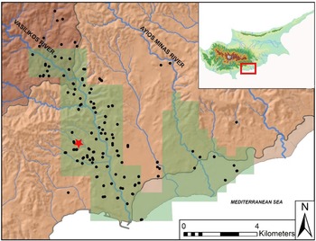
Legacy survey data as well as more recent targeted pedestrian survey conducted in the Vasilikos Valley, an alluvial watershed that empties into the south-central coastal plain of the island, suggests the proliferation of sites of inhabitation and activity during the later 9th to 7th centuries BCE (the Cypro-Geometric III period; Kearns Reference Kearns2023, 210–221; Kearns and Georgiadou Reference Kearns and Georgiadou2021; for survey synthesis see Todd Reference Todd2004, 58–60; Figure 1). Surface assemblages of typical Iron Age ceramic wares as well as building stones point to initial activity in areas of long-term settlement, particularly along river terraces and the coastal plain. Also attractive were higher-elevation locations on limestone hillslopes near copper-ore-bearing terrain with pine and oak forests. The previous periods of the 11th to 9th centuries BCE, following the end of the Late Bronze Age period, are less archaeologically traceable through surface assemblages, implying some kinds of settlement disruption or transformation.
Map of the Vasilikos Valley and its geomorphological contexts on the south-central coast of the island, showing survey boundaries in green and surface scatters related to 8th to 5th centuries BCE as black circles. Kalavasos Vounaritashi marked as red star. Image created by author using data from the Geological Survey Department of Cyprus.
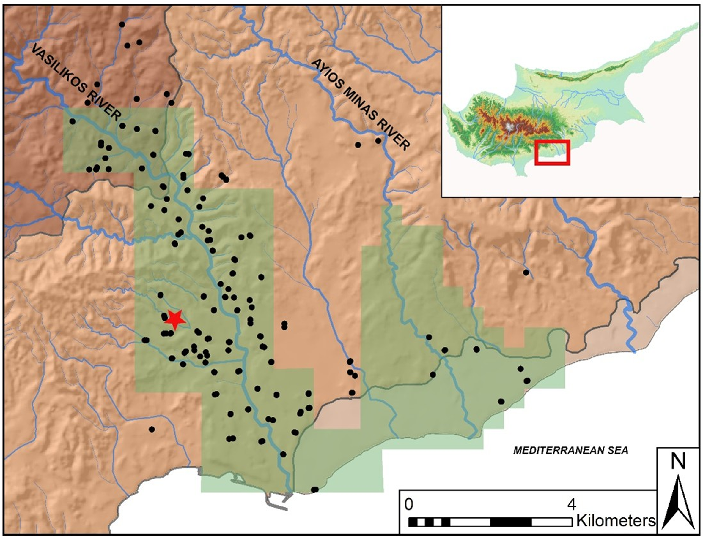
Figure 1 Long description
The map displays the Vasilikos Valley and its geomorphological context on the south-central coast of Cyprus. Survey boundaries are marked in green, and surface scatters related to the 8th to 5th centuries BCE are indicated by black circles. Kalavasos Vounaritashi is highlighted with a red star. The map is created using data from the Geological Survey Department of Cyprus.
The subsequent manifestation of settlement and land-use evidence by the 8th century BCE thus indicates an oscillation in more permanent forms of living, including connections to an emergent urban centre, Amathus, roughly 20 km to the west. The people living in the Vasilikos likely became part of the territorial extent of Amathus, paying forms of tribute or taxation to the city. By the early 7th century BCE, survey evidence shows signs of production regimes related to quarries of gypsum and limestone, copper mining and forest management in addition to a presumed network of plots for mixed cultivation, arboriculture and animal husbandry. Communities were, at the same time, delineating new places for cemeteries and tombs and ritual practices as well as shrines that accommodated local and interregional gatherings for differentiated social groups (Kearns Reference Kearns2023). Ceramic analyses of surface assemblages confirm the diachronic nature of certain areas of the valley during this Iron Age period, with evidence for reuse and resettlement of earlier prehistoric places as well as more temporally discrete assemblages that suggest short-lived practices (Georgiadou Reference Georgiadou and Hulin2018). While the available reconstructions of regional environmental change during the Iron Age lack chronological resolution, we can surmise broad, century-long shifts in water availability in this semi-arid area and the likelihood of more reliable access to water via springs and rainfall patterns (Kearns Reference Kearns, Kearns and Manning2019). Following this settlement growth and productivity, survey records show a drop-off of sites during the 4th to 1st centuries BCE, and scholars have traditionally assumed major demographic and settlement declines until a new configuration of towns, sanctuaries and ports emerged during the Roman period (Rautman Reference Rautman and Todd2016).
It is alluring to see these valley-wide settlement shifts through the lens of resilience and the adaptive cycle, by synchronizing reduced occupation activity with signs of stress and less resilience, reorganization with those of ‘favourable’ conditions and increasing resilience. But resilience thinking is a limited explanatory framework for the Vasilikos Valley’s Iron Age histories for several reasons. First, the analytical resolution of the archaeological and paleoenvironmental evidence cannot adequately be modelled into clear phases of conservation, release or reorganization. Without excavations of the surface assemblages, mostly collected and identified through extensive and intuitive survey during the 1980s, it is difficult to delineate the specific logics or causes behind cycles of economic growth or the waxing and waning of settlement structures. Our currently poor knowledge of ceramic typologies of local plain ware vessels, typical of the kinds of agropastoral processing related to strategies of storage or local production, further inhibits more granular analyses of land use to the presence or absence of fine wares. What, then, should be measured to quantify resilience? While the presence or absence of sites could be generalized to fit the metaphor of the adaptive cycle, the concept essentializes roughly three centuries of settled life and cannot effectively capture the dynamics of settlement growth or change (e.g. Meyer and Knapp Reference Meyer and Knapp2021).
Even with better resolution, resilience theory would not clarify or explain the evidence for the heterogeneity of small settlement networks. Not every surface scatter can be equated to a residence with associated farmed, irrigated or grazed land, nor is every imported vessel a sign of economic integration via strong or weak foreign trade. Some Iron Age surface scatters, for example, appear indicative of ephemeral areas of work or gathering; others are clearly oriented towards resource extraction. Others have signs of consumption associated with long-term sustained growth, such as those situated on well-watered terraces and full of commodity transport vessels. Others show no overt connections to interregional trade but do possess intergenerational burial grounds (Kearns Reference Kearns, Hall and Osborne2022). While it might describe this spatiotemporal variation as inherent complexity organized through looping cycles, resilience thinking is insufficient for explaining these divergences from the material records. Surface assemblages cannot reveal whether the inhabitants independently managed these resource materialities or were bound in extractivist dependencies with nearby states, especially the town of Amathus, a growing centre of interregional trade. It is difficult to hypothesize who the people were who inhabited and worked these landscapes, along lines of class, community or political status, among others. We should be mindful, moreover, of correlating proximity to resources with explanations of resource control or accessibility (Bridge Reference Bridge2009).
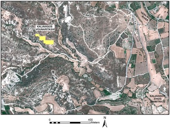
Zooming into smaller scales of analysis exposes this analytical and interpretative complexity. Pilot research at a site called Kalavasos Vounaritashi, in a small side drainage of the Vasilikos Valley and with evidence of activity from prehistory to the Roman period, has initiated more granular investigations of the connections between Iron Age rural communities and changing environments (Kearns and Georgiadou Reference Kearns and Georgiadou2021; Figure 2). The site’s position near probable springs in periods of more water availability, as well as smaller alluvial drainage channels, suggests the appeal of landscape features for seasonal agropastoral tasks during the 8th and 7th centuries BCE. Nearby residues of land-use features, like walls connected to an earlier, Late Bronze Age settlement called Kalavasos Ayios Dhimitrios, likely afforded inhabitants landesque investments. Vounaritashi’s position near coastal routes of communication provided the settlement with some access to local and regional networks. The site’s proximity to numerous surface outcroppings of gypsum, a lithic material increasingly commodified for local and interregional building projects during this period, was also likely attractive for additional year-round work. Gypsiferous terrain such as this comes with short-term risks, however, in the susceptibility of soils to weather and precipitation as well as to geochemical variability and attendant consequences for crop cultivation. In addition, the lack of concrete evidence for an associated cemetery or nearby tombs fits a pattern of a small, seasonal site.
Satellite image of Kalavasos Vounaritashi showing survey grid in yellow, bounded by alluvial channels. Image created by author using data from the Geological Survey Department of Cyprus.
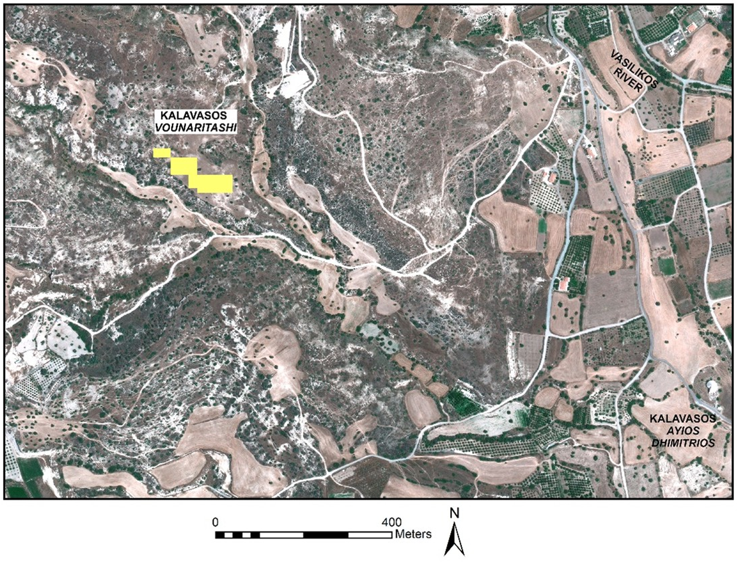
Figure 2 Long description
The satellite image displays the area of Kalavasos Vounaritashi, highlighting a survey grid marked in yellow. The grid is bounded by alluvial channels, indicating the geographical features of the region. The image is created using data from the Geological Survey Department of Cyprus.
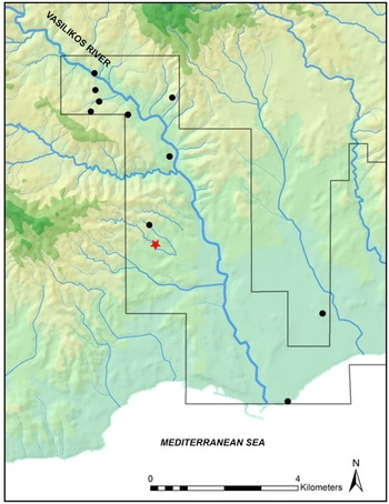
While intensive pedestrian survey suggested a discrete area with occupation from the 8th to 5th centuries, test excavations have revealed at least two stone-built structures whose masonry styles and discarded ceramics, from preliminary analysis, appear to date no earlier than the 5th or early 4th century BCE (Kearns and Georgiadou Reference Kearns and Georgiadou2021). This time lag of centuries between surface and subsurface materials is not only challenging to explain, given the relative isolation of the assemblages on the plateau, but raises problems of interpreting site resilience. We lack many comparanda from excavations of domestic settlements on Cyprus, but excavations of larger sites of long-term occupation from the 8th or 7th century BCE to the Roman period have recorded some parallels. Architectural forms of the Hellenistic and Roman periods covered over the more ephemeral traces of earlier periods, only visible in pits (e.g. Panayia Ematousa (Sørensen and Winther-Jacobsen Reference Sørensen and Winther-Jacobsen2006); Hill of Agios Georgios (Pilides Reference Pilides, Cannavo and Thely2018)). Smaller sites like Kalavasos Vounaritashi might have involved different infrastructural constraints: did people work over generations to create productive soils or quarrying operations, only later turning to permanent occupations after expectations of labour and harvests or the material conditions had been met? One might conjecture that whoever worked here began to anticipate stable conditions tied to seasonal water availability, the presence of woodland or the viability of gypsiferous soils, among myriad other factors, which came to require different kinds of rooted and localized practices of construction, occupation and day-to-day tasks. The current lack of evidence for an associated cemetery reaffirms that sites like Vounaritashi were work-oriented taskscapes, managed by households or supra-household collectives, which secured social life to land in less permanent ways. The apparent abandonment of the site at some point during the 4th or 3rd century BCE points to the possibility of shifting resource valuations and unmanageable practices, but our chronological handle on the evidence again creates challenges (Figure 3). The work at Kalavasos Vounaritashi throws assumptions of a ‘bust’ decline phase into question, and it is highly likely that many sites of the earlier Iron Age period show continuous or intermittent activity into the 4th to 1st centuries BCE but have gone unrecognized due to the coarseness of surface records.
Distribution of recorded sites with evidence dating to the Classical and Hellenistic periods, Vasilikos Valley Project. Image created by author.
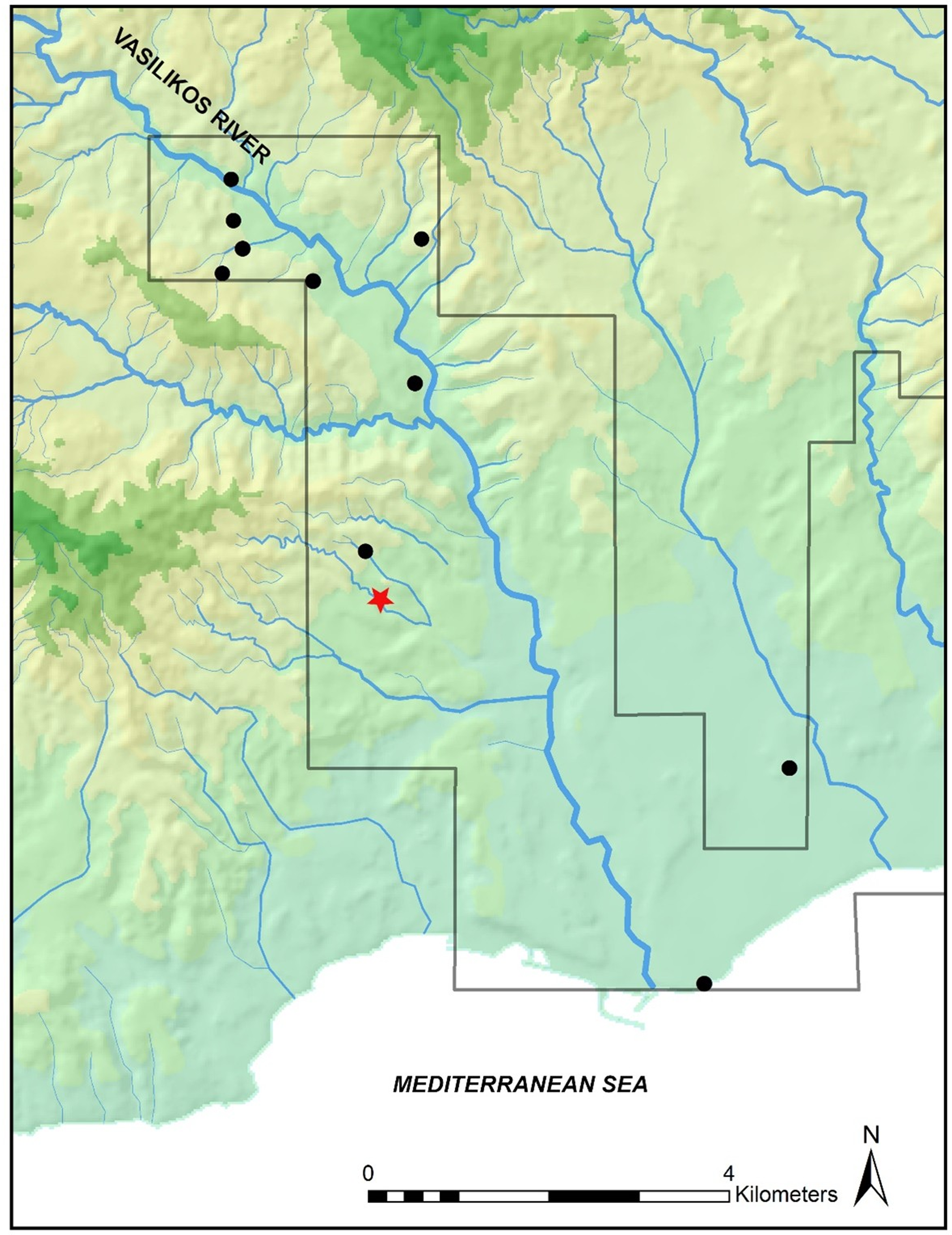
Figure 3 Long description
The map displays the Vasilikos Valley with various recorded archaeological sites marked by black dots. A red star indicates a specific site of interest. The map includes the Vasilikos River and the Mediterranean Sea, with a scale bar indicating distances in kilometers. The area is divided into sections, highlighting the distribution of sites within the valley.
Imposing a theory of destabilizing triggers, system survival or normative adaptations to stress on to the settlement pattern evidence would fail to produce effective causal arguments as well as obscure the social histories driving these landscape transformations. Measuring continuity or persistence of small sites as signs of inherent levels of resilience or vulnerability would overemphasize the longevity of rural places or reduce them to nodes of production in service of the larger system’s inevitable rhythms of stability and transformation. Treating a site like Kalavasos Vounaritashi instead through the lens of political ecology would centre its distinct landscape temporalities, which were created not just through values of economic productivity or resource use but through emerging kinds of community development and landscape curation. While based on preliminary evidence, we can posit that inhabitants forged practices of production and consumption here that were built across generations, from the 8th to 4th centuries. The wider regional setting by the end of occupation, including the height of urbanization of the closest town at Amathus and the possible increasing demands of state tax systems, may have made the conditions of living and working untenable, or the work of quarrying for gypsum or cultivating gypsum-rich soils may have lost whatever value they had accrued generations earlier; landscape tasks related to timber acquisition or copper mining upriver, moreover, created increasingly unwieldy legacy effects like acid drainage that made soils more susceptible to erosion (Kearns Reference Kearns2023, 210). Future investigations at the site could also work to ascertain the material patterns of abandonment, assessing what kinds of infrastructure or persistence were maintained and which were not. If Kalavasos Vounaritashi does represent a real unmaking of sustainable practices and displacement or abandonment, the identification of structures of control and ownership becomes critical to the attempt to interpret modes of vulnerability, precarity, tolerability or abundance.
Conclusion
Resilience theory as it has recently been taken up by landscape archaeologists, often slipping between analysis and metaphor, suffers from several weaknesses that limit its use for understanding the multiscalar complexity of past human–environment relationships. At the interpretative level, its biopolitical and scientific epistemology downplays the social in service of ecosystems thinking that views humanity as reactively engaged with an external, destabilizing nature. Methodologically, resilience thinking relies on coarse approximations of human action that reduce settlement evidence to nodes of production and obscure temporal and spatial dynamics. In its reliance on normative assumptions, inflected by contemporary neoliberal discourse, resilience thinking uncouples human practices from their landscape contexts, and I have proposed, like others, that we turn from systems thinking towards political ecology (Bauer Reference Bauer2025; Marston Reference Marston2025).
Despite its limitations, there is certainly space for quantitative, rigorous models that pursue questions of trigger and response for specific, empirically constrained historical cases and that stimulate more balanced treatments of collapse studies (e.g. Haldon Reference Haldon, Pohl and Kramer2021; Smith Reference Smith2023). It is important to continue scholarship that robustly tests and analyses causal relationships of long-term landscape change or practices of adaptation and mitigation, while acknowledging the vast differences between pre-modern and contemporary systems (Marston Reference Marston2025). As Morehart (Reference Morehart2010, 32) argues well, ‘we should not abandon concepts such as sustainability. Instead, they should be rendered more historically realistic, and hence useful, by considering how they are situated in different times and places and for different peoples’ (see also Logan Reference Logan2023).
These provocations indeed urge more work at diverse scales, to understand better the places and tempos of political and social action, to be able to connect them to landscape practices and chart how scalar relations were differentially and unevenly constructed. I do not just mean to gesture for more recognition of human agency but rather to push for more empirical and comparative analyses of households, kinship practices and family structures, and supra-household collectives, to build up our ability to discern patterns as well as to explain variances and anomalies (Kearns Reference Kearns2025b). I reiterate here others’ work to acknowledge that the ‘ability of households to reproduce themselves is grounded in their daily maintenance of practices of co-participation, rather than in the transmission of essential normative models’ (Vives-Ferrándiz Sanchez Reference Vives-Ferrándiz Sanchez2024, 235). In Mediterranean landscape archaeology, intensive survey methodologies have long taken precedence, and many have confirmed the challenges of funding and permitting the excavation of survey sites, but we desperately need resolution on surface assemblages. Targeted excavations and comparative rural and domestic archaeologies will bring much needed stratigraphical evidence of the logics that structured how people unevenly experienced environmental changes and which values they chose (or were compelled) to invest in, maintain or pass on to future generations (e.g. Bowes Reference Bowes2020). A focus on liveable practices can further stimulate analyses of the critical fault lines contributing to practices of production, consumption or discard: gender roles, class and inequality, citizenship and enslavement, colonization and indigeneity.
There is room to counter the essentializing and reductionist problems inherent to resilience thinking, and to critique normative claims about the resilience of socioecological systems in the face of climate crisis, past and present. Mediterranean landscape archaeology is particularly well suited to such directions given the availability of intensive survey records, increasingly accessible information on local and regional environmental histories and textual archives that supplement analyses at multiple scales. If our work on pre-modern landscapes is to matter to the present, let it be to expose the historical contingencies and dimensionality of liveable practices and the politics of difference that shape ideas of and engagements with material surroundings.
Acknowledgements
I am grateful to the two anonymous readers who provided thoughtful comments and clarity to the arguments, to the editors of Archaeological Dialogues for the forum to share these ideas and to Sarah Newman and R.A. Sandy Hunter for their insightful critiques. Students in Energy History at the University of Chicago were early and engaged interlocutors as were audiences at the University of Toronto and University of Pennsylvania. Research conducted on Cyprus through the KAMBE Project was funded through the Loeb Classical Library Foundation and the College of the University of Chicago, and I thank Anna Georgiadou for her collaboration. All errors or omissions are my own.

 Open access

