Introduction
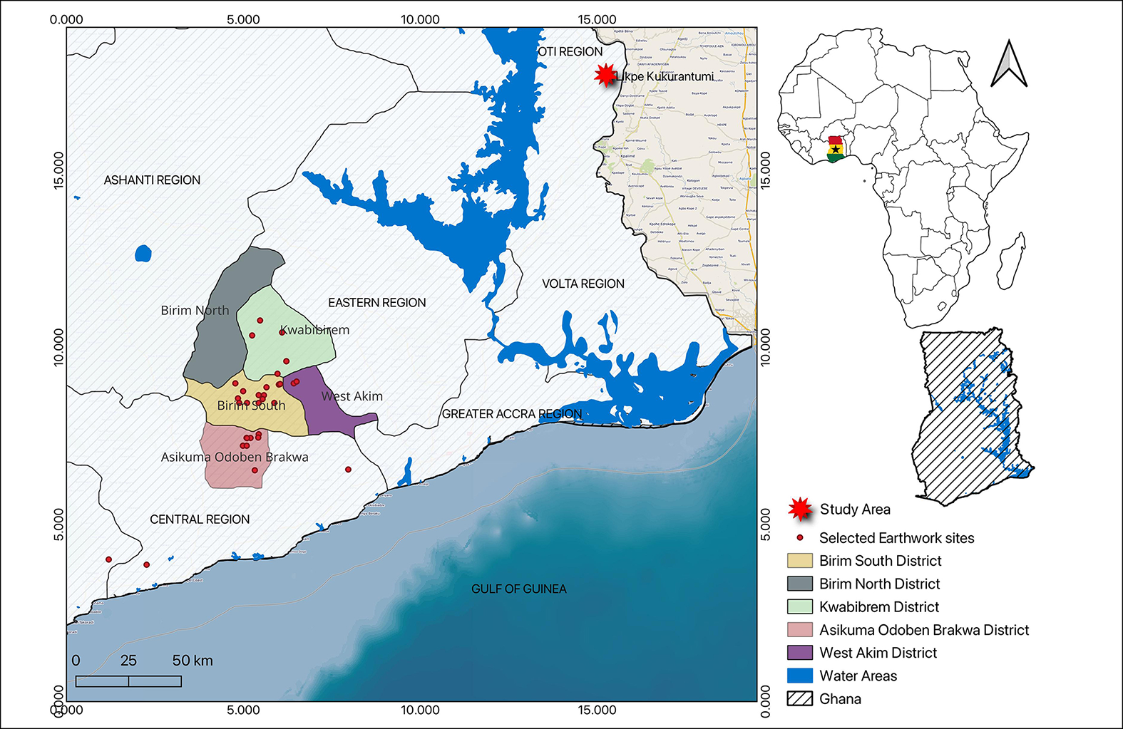
The Likpe Kukurantumi Archaeological Project (LKAP) is a multidisciplinary, community-based archaeological project in Ghana and its primary goal is to better understand the earthwork site, local vegetation, the chronology of the settlement and how the people interacted with their environment before and after the Atlantic era (AD 1450–l900). Research on earthworks in Ghana is essential for understanding past West African societies. Typical earthwork sites consist of a ditch flanked by one or two banks. Earthworks in the Birim South District, Kwabibirem District, West Akim District and the southern part of Ghana have received some attention (Junner Reference Junner1931; Davies Reference Davies1961; Kiyaga-Mulindwa Reference Kiyaga-Mulindwa1978, Reference Kiyaga-Mulindwa1982; Chouin Reference Chouin2009; Boachie-Ansah Reference Boachie-Ansah2010, Reference Boachie-Ansah and Anquandah2014; Biveridge Reference Biveridge2011), but the Likpe Kukurantumi Earthwork, the first earthwork site in the eastern part of Ghana (Oti region), has not previously been explored (Figure 1).
Map of Ghana showing the locations of Likpe Kukurantumi and selected earthwork sites (figure by authors using QGIS version 3.36.2).

Figure 1 Long description
A map of Ghana highlighting the Likpe Kukurantumi study area and selected earthwork sites. The map includes regions such as the Ashanti Region, Eastern Region, Volta Region, Greater Accra Region, and Central Region. It marks the Birim South District, Birim North District, Kwabibirem District, Asikuma Odoben Brakwa District, and West Akim District. Water areas are depicted in blue, and the study area is marked with a red star. Selected earthwork sites are indicated with red dots. The map also includes a small inset map of Africa highlighting Ghana's location.
Topography, excavation and methods
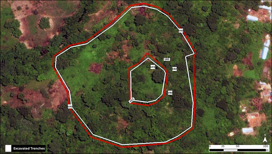
The Likpe Kukurantumi Earthwork is about 9km from the Buem-Togo Range, also called the Togo Mountains or Akwapim Range, which is 741m high. A GPS survey was conducted using a tripod-mounted receiver to enhance positional accuracy. Georeferenced co-ordinate points were collected at intervals along the site boundary and associated earthwork features. The spatial data were exported and processed in AutoCAD to generate a scaled plan of the site plan. This mapping revealed two embankments, each consisting of a ditch enclosed by two banks (Figure 2). The outer embankment has a diameter of approximately 219m while the diameter of the inner embankment is roughly 65m (Figure 3). Archaeological excavations focused on gathering archaeobotanical data to understand human-plant interactions over the last 500 years. Wood charcoal and carbonised plant remains were acquired by flotation and wet sieving using 2.5, 1.0 and 0.5mm meshes, and seeds were sent for radiocarbon dating.
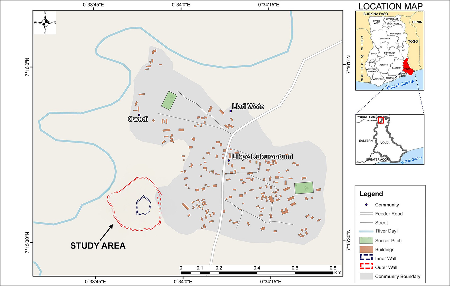
Likpe Kukurantumi showing the study area and location of embankments (source: Centre for Remote Sensing and Geographic Information Services, University of Ghana, Legon).

Figure 2 Long description
The map displays the Likpe Kukurantumi Archaeological Project study area in Ghana, highlighting key communities such as Owedi, Liati Wote, and Likpe Kukurantumi. It includes feeder roads, streets, the River Dayi, soccer pitches, buildings, and earthwork features like inner and outer walls. The study area is marked with specific boundaries and is located in the Oti region of eastern Ghana. The map also provides location context within Ghana and West Africa, showing neighboring countries and regions.
Likpe Kukurantumi Earthwork Site showing the location of the embankments and excavation test trenches (figure by Patricia Ayipey; image of the area from Google Earth).

Figure 3 Long description
The map displays the Likpe Kukurantumi Earthwork Site, highlighting the locations of embankments and excavated trenches. The site is marked with red and white lines indicating the boundaries of the embankments. Several trenches are labeled with codes such as JA1, JA2, UB1, UB2, UB3, UC1, and VA1. The map is overlaid on a satellite image of the area, showing a forested region with some cleared patches. The scale at the bottom right indicates distances in meters.
Direct observation of ethnobotanical practices among the local population also formed part of the LKAP, to gather information about the everyday use of plants. Ethnobotanical studies help understand the availability of certain trees, their use as firewood and insights into the local ecosystem. Ethnographic interviews with local inhabitants record plant-use knowledge, linking ancient archaeobotanical data with current practices.
Current results
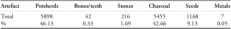
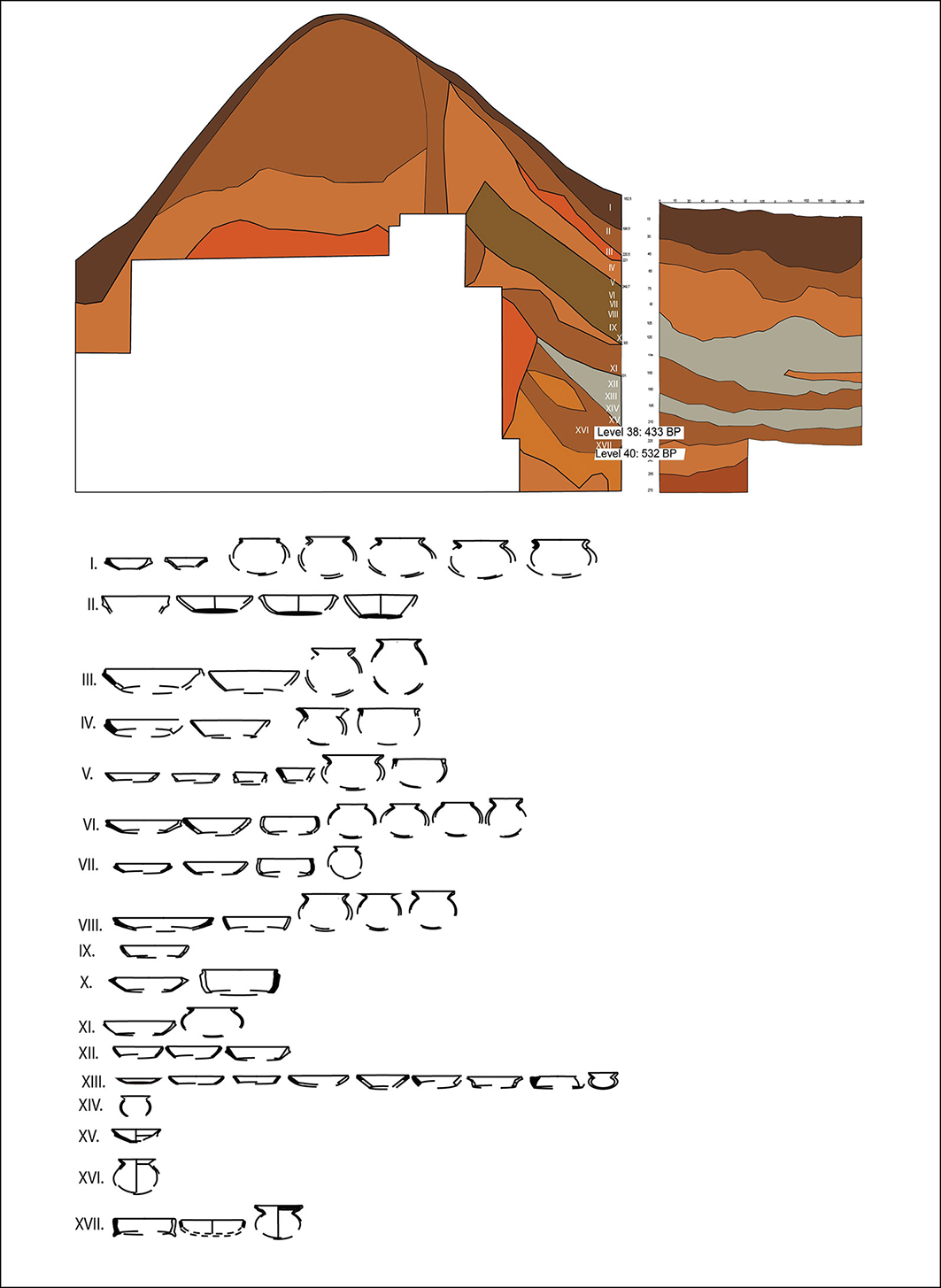
The excavation of seven trenches (Figure 3) yielded thousands of small finds, including local ceramics, wood charcoal fragments, charred and uncharred seeds, stones/querns, snail shells, corroded lumps of metal and a few bones (Table 1). Most artefacts recovered from the study area came from the northern section of Unit C2 (UC2 in Figure 3; 1 × 10m). Pottery fragments are of a coarse fabric from various vessel forms, including bowls, globular pots and jars (Figure 4). An upper stone quern was identified, though there is no evidence of the corresponding bedstone; other stones resemble the stream gravel found in the nearby Dayi River.
Artefact assemblage from Likpe Kukurantumi earthwork site.

Unit C2 soil profile and ceramic vessel forms (figure by authors).

Figure 4 Long description
The image presents a cross-sectional view of a soil profile with distinct layers labeled from I to XVII. Each layer is color-coded to represent different soil strata, with specific levels marked by their depth in centimeters and corresponding dates in before present (BP). The right side of the cross-section highlights levels 38 and 40, dated to 433 BP and 532 BP, respectively. Below the cross-sectional view, various ceramic vessel forms are illustrated, categorized by their respective soil layers. These vessel forms vary in shape and size, providing a visual representation of archaeological findings associated with each soil layer.
Finds commonly associated with earthwork sites include pottery, which appears to date back to pre-European times (first millennium to the middle of the second millennium AD), as well as tuyeres, iron slags, polished stone axes, the bones of wild animals and mollusc shells. Two pottery types have been identified across the earthwork sites in the Birim Valley and southern Ghana: ‘Atetefo’ (or earthwork) ware and ‘Atwea’ (or Akan) ware (DeCorse Reference DeCorse2001). Atwea ware is still used among the present-day Akan in Ghana (Chouin Reference Chouin2009). Analysis of the pottery from the Likpe Kukurantumi Earthwork is ongoing, so a particular ware type cannot yet be pinpointed; however, initial observations indicate that most of the sherds from Unit C2 (Figure 5) are yellowish-red to yellowish-brown in colour, and typically have gritty, worn surfaces and are often eroded. An elephant femur was also found in the eastern section of this excavation unit, prompting a 1 × 2m extension to recover it fully.
Unit C2 with its extension (inset) (figure by authors).

Figure 5 Long description
The image presents a cross-sectional view of an archaeological earthwork unit labeled as Unit C2, featuring a main section and an inset extension. The main section shows a large, curved excavation with distinct layers of soil, indicating different periods of activity or construction. The inset extension, displayed in a smaller image within the main view, reveals a more detailed, smaller-scale excavation with similar soil stratification. The cross-section highlights the structural complexity and historical layers of the earthwork, providing insights into past human activity and environmental interactions.
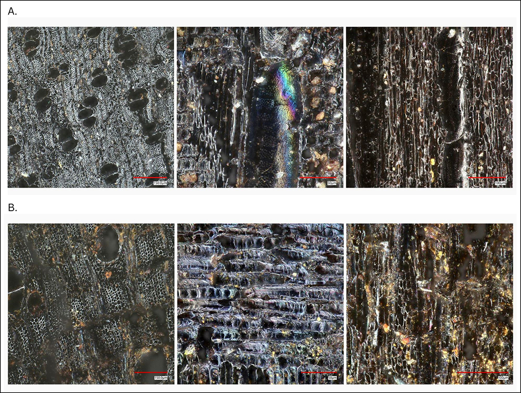
Archaeobotanical analyses are ongoing. Some wood charcoal fragments recovered from a depth of 3.80m in Unit C2 have anatomical features that allow them to be tentatively identified as Diospyros viridicans (Ebenaceae) and Xylopia sp. (Annonaceae) (Figure 6). Trees of the genus Diospyros have versatile uses, producing edible fruits and valuable timber, but also being used for ornamental purposes and remedies in various folk healing practices. The fruit of Diospyros viridicans is gathered for food and medicine (Tropical Plants Database 2024), likewise the fruits of one widespread African Xylopia species, X. aethiopica, are used as a spice and as medicine. The people of Likpe Kukurantumi speak Guan and Ewe dialects; they call this species etso. Preliminary analysis shows that oil palm (Elaeis guineensis) dominates the carbonised carpological remains. This species is endemic to the tropical forests of West and Central Africa and plays a vital role in local ecosystems; its leaves are collected for thatching and mats, fruits for palm oil, trunks for palm wine and kernels for palm kernel oil. The identified taxa—Elaeis guineensis, Diospyros viridicans and Xylopia sp.—reflect the semi-deciduous forest ecology of Likpe Kukurantumi, indicating a mixed woodland or forest environment shaped by natural vegetation and human management.
Transverse, tangential and radial sections from left to right of: A) Ebenaceae, cf. Diospyros viridicans wood charcoal; and B) Annonaceae, Xylopia spp. wood charcoal. Scale bars 50–150 microns (figure by authors).

Figure 6 Long description
The image displays transverse, tangential, and radial sections of wood charcoal from two different plant families. On the left, the sections are from Ebenaceae, specifically Diospyros viridicans wood charcoal. The middle section shows a close-up with a rainbow-like iridescence, indicating structural details. On the right, the sections are from Annonaceae, specifically Xylopia species wood charcoal, showing a more fibrous and eroded texture. Each section is labeled with a scale bar indicating 50 to 150 micrometers.
Radiocarbon dates for the Likpe Kukurantumi earthwork are available from the lowest part of the inner embankment (4m above the datum point of Unit C2), calibrated to 532 BP (1418 AD) and from 3.8m above the datum point, calibrated to 433 BP (1517 AD). Both are from fragments of Elaeis guineensis endocarp. Another date comes from an unidentified charred seed found 0.50m above the datum point in the ditch of the outer embankment (Unit A1, level 5): 1683–1759 AD. This is noted here for chronological context but, as it derives from a disparate excavation unit, it may not directly correspond to level 5 in Unit C2. Together, the three dates indicate the site’s occupation span.
Conclusion
The LKAP is an ongoing project; the identification, exploration and excavation of the earthwork site have been intrinsic, with community members aiding fieldwork and informing charcoal interpretation. Understanding the human–environmental interaction of the fifteenth-century AD settlement is essential in adding to the discourse on local vegetation change and understanding foodways of populations present during the opening of the Atlantic era in West Africa.
Acknowledgements
We thank the Likpe Kukurantumi community for their invaluable support throughout the project.
Funding statement
The LKAP received support from the National Geographic Society Grant (Grant NGS-EC-96169R-22), the Grant Agency of the University of South Bohemia (GA JU 109/2022/H) and the Erasmus+ Mobility programme.