


Introduction
During the Late Pleistocene (around 80–49 ka), the southern Levant functioned as an important corridor connecting Africa, Asia and Europe and probably served as a conduit for the movement of Middle Palaeolithic (MP) hominins in both directions. At this critical time in human evolution, the northern Negev ecotone, lying at the boundary between the Mediterranean and desert regions, could have served as a region where divergent Neanderthal and modern human groups interacted, leading to increased cultural complexity and the rise of new technologies (Greenbaum et al. Reference Greenbaum, Friesem, Hovers, Feldman and Kolodny2019). In the search for such evidence, a survey of prehistoric sites was conducted in the lower Besor Basin, north-western Negev (Figure 1), with many new sites identified (Goder-Goldberger et al. Reference Goder-Goldberger, Lavi, Horwitz, Bar-Yosef Mayer and Edeltin2019).
a) Map of Besor Basin projected on digital elevation model; b) sites along the Besor. Outlined in yellow are kurkar outcrops; c) view west of the loess badlands and B37 (figures 1a and 1b by O. Crouvi; figure 1c by M. Goder-Goldberger).

The Besor Basin is the largest drainage system in the Negev Desert that flows to the Mediterranean Sea (Figure 1). The lower segment of the Besor is characterised by a series of perennial springs and a savanna-like landscape, providing a rich intermediate ecozone (Kark & van Rensburg Reference Kark and Van Rensburg2006) that would have attracted both animals and hominins. Throughout the Late Pleistocene, the lower Besor Basin was filled with fluvial loess deposits up to 20m thick (Crouvi et al. Reference Crouvi, Amit, Israel, Enzel, Bar-Yosef and Enzel2017). Subsequent erosion of the loess over the last 12 000 years has resulted in today's dissected landscape and the exposure of numerous buried Palaeolithic sites (Goder-Goldberger et al. Reference Goder-Goldberger, Lavi, Horwitz, Bar-Yosef Mayer and Edeltin2019).
Following the survey, and due to the unique ecological and depositional environment of the lower Besor Basin, we are currently carrying out a broader interdisciplinary regional project titled ‘Late Quaternary infill and incision in the Besor Basin, northern Negev: landscape evolution, human adaptability and cultural change’. The project aims to understand the influence of landscape evolution on human settlement patterns in this ecotone.
In 2020, excavations were conducted at two of the late MP open-air sites identified in the survey, B37 and B27, in an attempt to reconstruct the palaeoenvironment and Palaeolithic settlement patterns of this unique ecotone (Kark & van Rensburg 2006). At each of the sites, a 1×1m grid was established and excavations were done in 50mm spits. All finds were piece-plotted with a total station and sediments were dry sieved with a 2mm mesh. For environmental reconstruction, sediment samples were collected for pollen identification and stable isotope analysis.
The sites
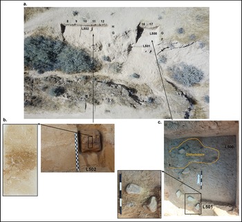
B37 (Figure 2) is an in situ living surface with combustion features in association with lithic artefacts, including hammerstones and large flat stone slabs. The average thickness of the archaeological level is 70mm. In contrast, at site B27 (Figure 3), located 2km to the north, MP artefacts were retrieved from within a well-defined, stratified sedimentological layer of fluvial loess, on average 1m thick, that was overlain by a layer of clay-rich sediments and void of archaeological remains.
Site B37 – a) photo of main excavated area (photograph by L. Edeltin); b) block removed from combustion feature L502 and scan of a thin section from Block 1 displaying heat altered (reddish) silty clay crusts – short side is 70mm (scan by M.B. Toffolo); c) combustion feature L. 501 and the adjacent set stone slabs. Enlarged are stone slabs and flint artefacts (figure 2c by M. Goder-Goldberger).

Site B27: a) photogrammetry model of excavated area (model by E. Aladjem); b) thin sections from Blocks 3 and 4 were removed from sq. M-N 43. The unconformity between the loess and the overlying clay unit is marked with a yellow line (short side is 70mm) (scan by M.B. Toffolo); c) the section in sq. M-N 40 showing unconformity between units; Unit 2 is mostly clay and Unit 3 is composed of compact loess (figure 3c by M. Goder-Goldberger).

At B37 the flint assemblage consists of 1171 artefacts of which 60% are smaller than 20mm indicating minimal post-depositional disturbance. Of the artefacts larger than 20mm, 30% were refitted into 24 constellations. The lithic assemblage of B27 consists of 706 artefacts of which 30% are smaller than 20mm. Two refitted constellations, artefact freshness and the lack of patina suggest that post-depositional transport of artefacts within the site was limited. Lithic assemblages at both sites are characterised by Levallois unidirectional convergent technology, while Levallois points and flakes with chapeau de gendarme platforms are more numerous in B27 (Figure 4). Retouched artefacts are few: a retouched flake from B37 and two sidescrapers, two endscrapers and a truncated flake from B27.
Lithic artefacts: B37 – 1–3) Levallois points; 4) hammerstones; 5) refitted Levallois core, including four flakes and a point refit onto a unidirectional convergent Levallois core; B27 – 6–8) Levallois points; 9–10) refitted Levallois cores (photographs by I. Ostrovski).

At B37, the presence of amorphous organic matter, several fungal remains, and the absence of pollen, suggest wetting/drying processes (Campbell & Campbell Reference Campbell and Campbell1994). At B27, micro-charcoal fragments are abundant and several samples show rounding due to fluvial transport. Faunal remains comprise fragmented bones and tooth enamel of medium and large-sized herbivores, including some attributed to aurochs (Bos primigenius). Reworking, and oxidation due to fluvial activity at both sites, had an adverse effect on the preservation of faunal and pollen remains.
Site formation processes at both sites are different, possibly the result of the local topography that affected water flow and overbank sediment deposition (Figure 1b), as well as climate changes. Carbon and oxygen stable isotope values from the B37 sediments (Figure 5) are similar to those from the adjacent late MP site of Far'ah II (Figure 1), with δ18O typical of the relatively high values observed during the cold last glacial period (Bar-Matthews et al. Reference Bar-Matthews, Ayalon, Gilmour, Matthews and Hawkesworth2003; Goder-Goldberger et al. Reference Goder-Goldberger2020). At B27 the stable isotope values differ between the clay and loess units. The loess unit exhibits the most negative (low) values for both carbon and oxygen, possibly indicating warmer and wetter conditions (Bar-Matthews et al. Reference Bar-Matthews, Ayalon, Gilmour, Matthews and Hawkesworth2003). Dating of the sites is ongoing, but initial results indicate that B37 is similar in age to Far'ah II (48–49 ka), while B27 is somewhat earlier.
Oxygen and carbon stable isotope data from the three MP sites Far'ah II, B37 and B27 (figure by T. Zilberman).

Our research demonstrates that the thick loess accumulations along the Besor contain a rich record of MP human activity, featuring repeated visits to this favourable environment (Figure 6). Evidence from the excavations indicates that the inhabitants built and used combustion features on-site, knapped lithic artefacts, and processed and consumed prey and plants. The preliminary results of the presented research highlight the mutual benefits of combining sedimentological and archaeological data to reconstruct human-environment inter-relationships and to contribute to deciphering diachronic changes in cultural evolution.
Animal species identified in the Nahal Besor Middle Palaeolithic sites (Gilead & Grigson Reference Gilead and Grigson1984; Goder-Goldberger et al. Reference Goder-Goldberger2020) reflect the rich mosaic environment comprising Irano-Turanian grassland steppe, open Saharo-Sindian shrubland and riverine flatland (figure drawn by N. Nolte-Venturas).

Acknowledgements
The article is dedicated to Isaac Gilead who passed away in April 2023. This project would not have materialised without his support and dedication, and it benefited greatly from his insights. The Excavations at B37 and B27 (Israel Antiquity Authority permits G-39/2020 and G-40/2020 and the Israel Park Authority permit A29-20) were directed by M. Goder-Goldberger. Palynological samples were processed by Petrus Chakane. Photos are by M. Goder-Goldberger unless noted otherwise.
Funding statement
Excavations at B37 were funded by the Dan David Foundation, and at B27 by the National Geographic Society (Grant NGS-64652R-19). The ongoing project and analyses carried out at the respective collaborators’ laboratories are supported by the Israel Science Foundation (Grant 323/21).


 Open access