


Introduction
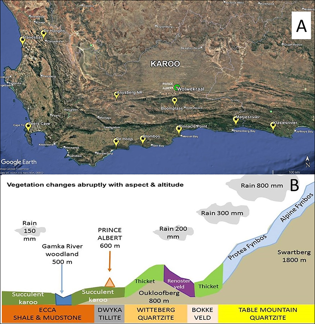
Although the arid Karoo occupies 35 per cent of South Africa (approximately 400 000km2), archaeological exploration of the region has been spatially uneven (e.g. Seacow Valley: Sampson Reference Sampson1985; Tankwa Karoo: Hallinan & Shaw Reference Hallinan and Shaw2020; see also Morris Reference Morris2018). Given its proximity to coastal sites and the Meiringspoort pass through the Swartberg Mountains (linking the interior to the coast), the Prince Albert area is of particular interest for studying past contact between the Karoo and coast (Figure 1A; Wadley Reference Wadley2014). Field surveys were initiated in 2023 at the Wolwekraal Nature Reserve (WNR; 33°11′48.48″S, 22°1′46.56″E) located 3km north of Prince Albert village on the inland slopes of the Swartberg Mountains (Figure 1B), an archaeologically understudied area (Rust Reference Rust2008; Maguire Reference Maguire2013; Tusenius Reference Tusenius2013). These aimed to: 1) locate and date archaeological sites within WNR; 2) explore the chronological and spatial relationship between sites; 3) contextualise sites in relation to natural features (topography, vegetation, geology, water and raw material sources); 4) examine links with the coast.
A) Major archaeological sites in the Southern and Western Cape: yellow ‘pins’ = caves/rock shelters; green circle = Wolwekraal Nature Reserve; B) altitudinal gradient, geology and vegetation of the research region (figure by S. Milton-Dean).

Figure 1 Long description
The image consists of two main elements: a map and a diagram. The map shows the Southern and Western Cape regions with various archaeological sites marked. Yellow pins indicate caves and rock shelters, while a green circle highlights the Wolwekraal Nature Reserve. The diagram below the map illustrates the altitudinal gradient, geology, and vegetation of the research region. It shows different types of vegetation zones, such as succulent karoo, thicket, and renosterveld, along with geological formations like Ecca shale and mudstone, Dwyka tillite, Witteberg quartzite, Bokkeveld, and Table Mountain quartzite. The diagram also indicates varying levels of rainfall across these zones.
The 123ha reserve lies within the Succulent Karoo biome at the foot of the Swartberg Mountains, offering a 1400m altitudinal gradient with changing geology, vegetation and precipitation (Figure 1B). The region receives sporadic rainfall throughout the year (<200mm/yr) with temperatures ranging between −2 and 45°C. The Dorps River, fed by the Swartberg Mountains, runs through WNR. During field surveys, we located five deflated open-air archaeological sites (labelled AOS, WKB, WKC, KRS1, KRS2), containing later Middle Stone Age (c. 130 000/40 000 BP) and/or late Holocene Later Stone Age artefacts (c. 3000/2000 BP; Figures 2 & 3).
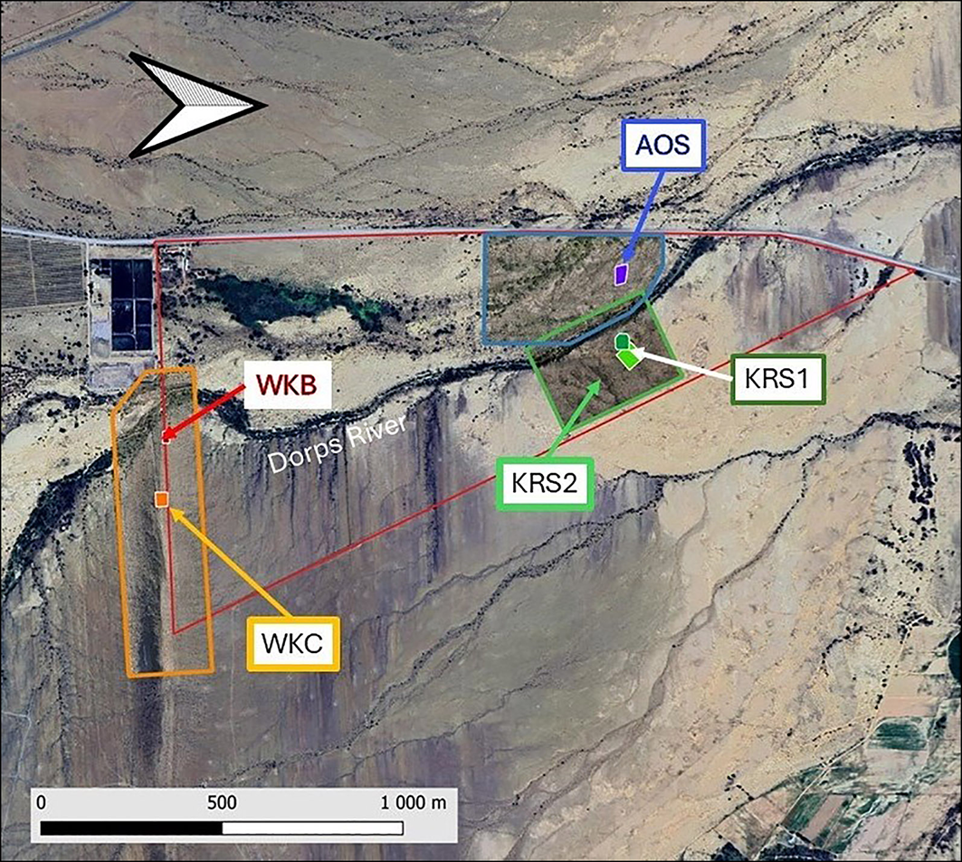
The three survey areas, showing the locations of the five sites and extent of image coverage (figure by S.G. Wessels & S. Milton-Dean).

Figure 2 Long description
The map displays the survey areas in the Wolwekraal Nature Reserve, located 3 kilometers north of Prince Albert village on the inland slopes of the Swartberg Mountains in South Africa. It highlights the locations of five key sites: WKB, WKC, KRS1, KRS2, and AOS. The map also shows the extent of image coverage and includes natural features such as the Dorps River. The survey areas are marked with different colored lines and labels, indicating the spatial distribution of archaeological exploration in the region.
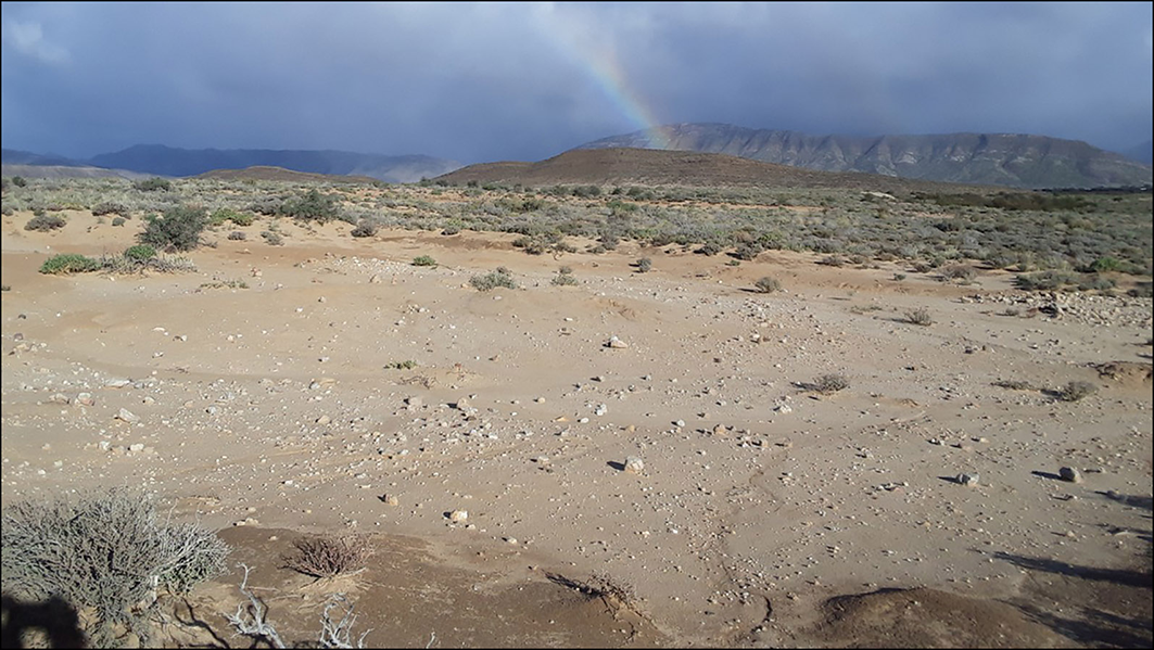
Deflated site AOS (figure by S. Milton-Dean).

Figure 3 Long description
The image shows a deflated archaeological site located in the arid Karoo region of South Africa. The landscape is characterized by sparse vegetation and rocky terrain, with distant mountains visible under a cloudy sky. The site is situated in the Wolwekraal Nature Reserve, approximately 3 kilometers north of Prince Albert village, on the inland slopes of the Swartberg Mountains. The area is of interest for studying past contact between the Karoo and the coast due to its proximity to coastal sites and the Meiringspoort pass.
Aerial imagery
For the mapping of spatial relationships and topographic features, three areas within WNR were selected for aerial coverage (Figure 2). A three-tiered approach was adopted for imaging: Google Earth satellite imagery formed the base images (Level 1), while drone images taken of the relevant areas at two distinct scales (Levels 2 & 3) provided both orthophotos and digital elevation models (DEMs). Level 2 images were obtained by flying the drone (using automated software ‘dronedeploy’) at a height of about 80m in an appropriate grid pattern, with suitable overlap, to create an orthophoto where 1 pixel = 25mm on the ground. The orthophotos were then georeferenced to Google Earth satellite imagery using an open-source Geographic Information System (QGIS version 3.42). Level 3 images of each of the five identified sites were captured by flying the drone manually in a grid pattern at 5–8m above the ground. This produced more detailed orthophotos of smaller areas (Figure 4A), where 1 pixel = 1–2mm on the ground, which provided sufficient resolution to mark on the images any artefacts identified in the field (Figure 4B). Artefacts were georeferenced using the Level 2 orthophotos.
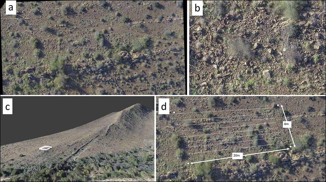
Site WKB: A) site overview (level 2); B) high-resolution orthophoto (level 3); C) 3D model highlighting site location below a ridge, the straight-line feature is a wall; D) find recording grid (figure by S.G. Wessels).

Figure 4 Long description
The image consists of four distinct elements: a photo, an orthophoto, a 3D model, and a grid diagram. The photo, labeled as A, provides a site overview at level 2, capturing the general landscape and features of the site. The orthophoto, labeled as B, offers a high-resolution view at level 3, detailing the specific area of interest within the site. The 3D model, labeled as C, highlights the site's location below a ridge, with a straight-line feature identified as a wall. The grid diagram, labeled as D, illustrates the find recording grid used for archaeological purposes. These elements are combined to provide a comprehensive view of the archaeological site WKB, located in the Wolwekraal Nature Reserve, South Africa.
The combined three-tiered visualisation of each site allowed analysis of topographic variations at two distinct scales (Levels 2 & 3), as shown, for example, in Figure 4C, which illustrates the ridgeline relative to site WKB.
On-site recording
In order to minimise disturbance to the reserve’s landscape and preserve the integrity of the sites, a non-invasive field protocol for recording individual finds was employed: items were picked up, identified, registered in a database, sometimes measured/photographed, and then returned to their original place. Rectangular string grids (Figure 4D) were laid out over two artefact-rich sites located 2km from each other and situated in different micro-habitats: site AOS on the plains near the Dorps River and site WKB on a hill slope above the river (Figure 2). Co-ordinates of the string grid corner points were recorded and projected onto the drone photographs. Each string grid was divided into contiguous 1m2 quadrats that were further subdivided into 100 cells. The presence/absence of finds and non-archaeological features was also recorded to enable spatial analyses.
More than 4000 archaeological objects were recorded at the two sites (Figure 5). At WKB (grid size 20 × 8m) these were largely Matjiesfontein chert flaking debris alongside a few quartzite manuports and abundant bone and ostrich eggshell fragments. AOS (grid size 20 × 16m; Figure 3) contained cores, blades, bladelets, scrapers and especially adzes. The tool types from both sites are typical of the late Holocene Later Stone Age (Deacon Reference Deacon1984). In terms of raw material, local Matjiesfontein chert predominates, while quartz chips and quartzite cobble manuports were also identified. The assemblages indicate that lithic production took place on site. Ceramics, including lugged amphora-shaped pottery lacking grass temper, typical of Khoekhoen pastoralists (e.g. Maguire Reference Maguire2013), was absent from AOS and WKB, but present at other sites in the reserve, such as KRS1 (Figure 6D). The pottery resembles finds from the Anysberg Nature Reserve (Rust Reference Rust2008), located approximately 70km from Wolwekraal. Other finds from the five WNR sites were: marine shells (indicative of coastal connections); ostrich eggshell fragments; beads of ostrich eggshell and glass; burned and unburned bone fragments from tortoises and small herbivores (Figures 5 & 6).
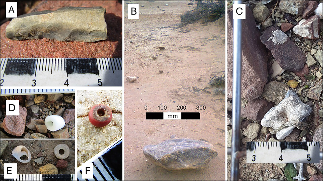
Artefacts from WKB: A) adze on Matjiesfontein chert; B) quartzite manuport; C) herbivore astragalus; D & F) glass trade beads; E) marine shell and ostrich eggshell bead (figure by S. Milton-Dean).

Figure 5 Long description
The collage consists of six separate images. Image A shows an adze made from Matjiesfontein chert placed on a red surface with a ruler below it for scale. Image B depicts a quartzite manuport on a sandy ground with a scale bar indicating distances in millimeters. Image C features a close-up of a herbivore astragalus bone surrounded by various rocks, with a ruler for scale at the bottom. Image D displays two glass trade beads, one white and one red, placed on a surface with small rocks. Image E shows a marine shell and an ostrich eggshell bead on a surface with a scale bar. Image F presents a close-up of a red glass trade bead on a surface with small rocks and a scale bar.
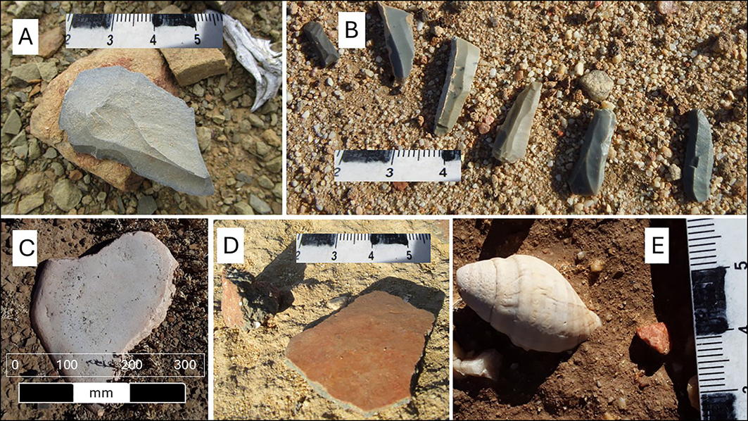
Finds from other sites in WNR: A) scraper on Matjiesfontein chert; B) bladelets on Matjiesfontein chert; C) lower grindstone; D) pottery; E) marine shell (figure by S. Milton-Dean).

Figure 6 Long description
The image contains five separate photos of archaeological finds from the Wolwekraal Nature Reserve in South Africa. Photo A shows a scraper on Matjiesfontein chert with a ruler for scale. Photo B displays several bladelets on Matjiesfontein chert, also with a ruler for scale. Photo C features a lower grindstone with a scale bar indicating measurements in millimeters. Photo D presents a piece of pottery with a ruler for scale. Photo E shows a marine shell with a ruler for scale. Each photo highlights different types of artifacts found during field surveys in the area.
Conclusion
Preliminary analyses of finds (tool types, microlithic size and retouch), indicate that most of the stone tools found at the two sampled sites are typical of the Later Stone Age and resemble those recorded at the Prince Albert Quarry (Tusenius Reference Tusenius2013). The lack of pottery at AOS and WKB may be an indicator of the activities undertaken on site, a chronological marker or relate to our random sampling method. The predominance of local Matjiesfontein chert as a raw material distinguishes the WNR assemblages from most other late Holocene Later Stone Age assemblages found in South Africa (Deacon Reference Deacon1984). The nearest chert sources are less than 3km from WNR while the quartzite manuports, which cover the WNR terrain, originate in the adjacent Swartberg Mountains.
The diversity of artefact-rich sites in WNR indicates that a range of activities took place on site. The presence of flaking debris, formally retouched lithics, groundstone artefacts and burnt faunal remains denote on-site tool knapping and food consumption, while the presence of marine shells points to contact with the coast, either through direct movement or exchange.
The size of the WNR sites makes it likely that most represent palimpsests of occupation events, the timing and duration of which will be elucidated by radiometric dating. The relatively large number of sites in such a small area indicates it was a favoured locality, probably occupied episodically and perhaps seasonally by one or more cultural groups. Given the harsh environment, occupations may have been linked to climate fluctuations and/or the palaeoecology of the riparian system of the Dorps River, which was the focus of occupation. This research augments our understanding of past human occupation of the South African arid interior.
Data availability
The Wolwekraal Project data are archived in the Archaeology Department, University of Cape Town.
Funding statement
Supported by the Rust Family Trust (USA) and Gouritz Cluster Biosphere Reserve NPC (South Africa).
Author Contributions: using CRediT categories
John E. Parkington: Conceptualization-Equal, Data curation-Equal, Formal analysis-Equal, Investigation-Equal, Methodology-Equal, Resources-Equal, Supervision-Equal, Validation-Equal, Writing - review & editing-Equal. Sue Milton-Dean: Conceptualization-Equal, Funding acquisition-Equal, Investigation-Equal, Methodology-Equal, Project administration-Equal, Resources-Equal, Supervision-Equal, Visualization-Equal, Writing - original draft-Equal. Ashley Christowitz: Data curation-Equal, Formal analysis-Equal, Investigation-Equal, Resources-Equal. Cedric Poggenpoel: Data curation-Equal, Formal analysis-Equal, Investigation-Equal, Methodology-Equal, Resources-Equal. Stephen G. Wessels: Investigation-Equal, Methodology-Equal, Resources-Equal, Software-Equal, Visualization-Equal, Writing - review & editing-Equal. Liora Kolska Horwitz: Conceptualization-Equal, Funding acquisition-Equal, Investigation-Equal, Methodology-Equal, Resources-Equal, Validation-Equal, Writing - original draft-Equal.

 Open access