Introduction
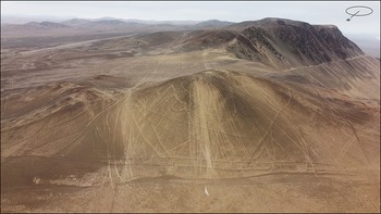
In 2024, the Desierto de Atacama Foundation publicly denounced the large-scale destruction of the Alto Caramucho geoglyphs (also known as Alto Barranco) in the Atacama Desert, caused by off-road vehicles (Figures 1 & 2). The international press widely reproduced the images, describing the situation as a global heritage disaster (see, for example, Basilio Reference Basilio2024), alongside countless examples of violations and tensions affecting ancient cultural expressions (e.g. Bahn Reference Bahn2010; Meskell Reference Meskell2025).
General location and photogrammetry of the panels and sectors identified by Pérez and Sandoval (Reference Pérez and Sandoval2020) (figure by authors).

Figure 1 Long description
The map displays the general location and photogrammetry of the panels and sectors identified in the Atacama Desert. It includes markers for panels Alto Caramucho Geoglyphs, paths, archaic period material culture, and archaeological structures. The map is overlaid on a satellite image of the desert, with specific points labeled as P1, P2, P3, P4, and P5. The inset in the top right corner shows a satellite view of South America, highlighting the location of the Atacama Desert in Chile. The map uses different colors and symbols to indicate various features and sites of interest.
Aerial view showing numerous vehicle tracks over the Alto Caramucho geoglyphs (photograph by authors).

Figure 2 Long description
An aerial view captures the intricate patterns of the Alto Caramucho geoglyphs, which are ancient designs etched into the earth. The geoglyphs are overlaid with numerous vehicle tracks, indicating human activity in the area. The landscape is arid, with rolling hills and mountains in the background. The tracks crisscross the geoglyphs, creating a complex network of lines and patterns.
Digital techniques such as aerial photogrammetry have proved especially useful for documenting, visualising and identifying geoglyphs (e.g. Pimentel et al. Reference Pimentel2017; Sakai et al. Reference Sakai2024; Sánchez-Borjas et al. Reference Sánchez-Borjas2024). Integration of artificial intelligence (AI) may now prove useful in monitoring their conditions. To assess the damage to the Alto Caramucho geoglyphs, we used the DeepLabv3 model, a semantic segmentation algorithm trained to detect tracks in desert terrain. Initially, 38.36% of the full aerial imagery was selected to create representative training data that captured the diverse characteristics of tracks. From this subset, we generated 91 non-overlapping grids of 768 × 768 pixels to ensure adequate spatial resolution for track detection while maintaining computational efficiency. To increase dataset size and improve model generalisation, each grid was further subdivided into 10 overlapping patches using a stride of 128 pixels. The dataset was partitioned, with 20% of the grids reserved for independent testing and the remaining 80% used to implement a three-fold cross-validation framework for hyperparameter optimisation of the DeepLabv3 semantic segmentation model (Chen et al. Reference Chen2017). The model was trained for 200 epochs, with early stopping implemented using a patience parameter of 20 epochs to prevent overfitting. We employed the AdamW optimiser with a learning rate of 0.0005 (Loshchilov & Hutter Reference Loshchilov and Hutter2019) and used weighted cross-entropy loss to address class imbalance between track pixels and background desert terrain, ensuring effective learning of minority class features essential for accurate track identification. The model achieved a final F1-score of 76.75% on the test set.
In addition to both digital techniques, we include the analysis of historical images of the geoglyphs, through which we aim to document and evaluate the damage history of the Alto Caramucho geoglyphs.
Damage assessment and the use of new technologies
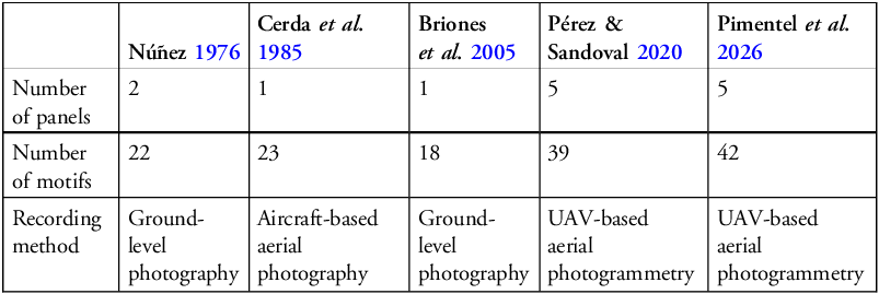
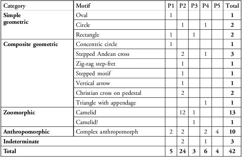
The Alto Caramucho geoglyphs have been recorded since the second half of the twentieth century, resulting in various depictions and interpretations (Tables 1 & 2; Schaedel Reference Schaedel1957; Iribarren Reference Iribarren1968; Núñez Reference Núñez1965, Reference Núñez and Núñez1976; Cerda et al. Reference Cerda and Aldunate1985; Briones et al. Reference Briones2005; Briones Reference Briones2008; Núñez & Briones Reference Núñez and Briones2017; Pérez & Sandoval Reference Pérez and Sandoval2020; Pimentel et al. Reference Pimentel2026).
Summary of panels and motif types recorded at the site.

Current record of the geoglyph panels (P) and motifs at Alto Caramucho (taken from Pimentel et al. Reference Pimentel2026).

The earliest available image of the site dates to about 1959 (Figure 3), showing the geoglyphs without any vehicle tracks, a condition also evident in photographs taken during the 1970s (Núñez Reference Núñez and Núñez1976: 155). The first image documenting substantial damage is from 2003 (Briones Reference Briones2008: 19; Bahn Reference Bahn2010: 175), after which deterioration accelerated exponentially, as revealed by satellite imagery from 2009 onwards (Figure 4).
Photograph taken by Jorge Checura (c. 1959) showing the geoglyphs without vehicle tracks (photograph courtesy of the Regional Museum of Iquique).

Figure 3 Long description
An aerial photograph captures the intricate geoglyphs of Alto Caramucho in the Atacama Desert. The geoglyphs, ancient designs etched into the desert floor, are visible from above, showing various geometric patterns and figures. The image highlights the pristine condition of the geoglyphs, free from vehicle tracks, providing a clear view of their original state. The surrounding landscape is arid and barren, emphasizing the stark contrast between the geoglyphs and the natural terrain.
Above) Photograph from 2003 (Briones Reference Briones2008: photo 6); below) satellite image from April 2009 (source: Google Earth).

Figure 4 Long description
The Alto Caramucho geoglyphs are displayed in two images. The top image is a photograph from 2003, showing a hillside with intricate, radiating lines and geometric patterns etched into the surface. The bottom image is a satellite image from April 2009, revealing similar patterns with a broader view of the surrounding landscape. These geoglyphs have been studied and interpreted by various researchers over the decades.
Our current aerial photogrammetry (Figure 5) and AI analysis reveal extensive vehicle-track damage, showing that 95% of the geoglyphs in the central area are affected (Figure 6), an alarmingly high proportion.
Photogrammetric detail of panel 2 (P2) (figure by authors).

Figure 5 Long description
An aerial photograph captures a detailed view of a geoglyph panel, showcasing intricate lines and patterns etched into the ground. The image reveals a complex network of grooves and ridges forming geometric shapes and designs. The lines radiate outward from a central area, creating a sense of symmetry and order. The photograph is taken from a high angle, providing a comprehensive perspective of the entire panel. The ground appears to be a mix of light and dark brown tones, with the lighter areas representing the etched lines and the darker areas the untouched surface. The image highlights the precision and craftsmanship involved in creating such large-scale earth drawings.
DeepLabv3 model showing a) training dataset and b) detected vehicular tracks across the site (figure by authors).

Figure 6 Long description
The image consists of two heat maps. The first heat map (a) shows the training dataset with unsurfaced tracks in yellow and roadless areas in blue. The second heat map (b) displays the detected vehicular tracks in red across the site. Both maps are overlaid on a satellite image of the terrain. The training dataset map highlights areas used for training the DeepLabv3 model, while the detected tracks map shows the model’s predictions of vehicular tracks. The maps use different colors to distinguish between training data and detected tracks, providing a visual comparison of the model’s performance in identifying tracks in desert terrain.
Conclusions
Over the past two decades, vehicles and off-road races have generated the principal damage to the Alto Caramucho geoglyphs, with a sustained and accelerating impact in recent years. In this context, aerial photogrammetry and artificial intelligence (DeepLabv3) are valuable tools for assessing the damage and supporting formal heritage denunciations.
Acknowledgements
To the community of Caleta Caramucho for their commitment to protecting the geoglyphs and to the Regional Museum of Iquique for kindly sharing with us the photograph taken by Jorge Checura.
Funding statement
This research was funded by the National Agency for Research and Development in Chile (ANID–FONDECYT REGULAR # 1261151 and 1221590).
Author contributions: CRediT categories
Gonzalo Pimentel G.: CRediT contribution not specified; Luis Pérez R.: Investigation-Equal, Writing - original draft-Equal, Writing - review & editing-Equal. Mariana Ugarte F.: CRediT contribution not specified. Juan Gili H.: CRediT contribution not specified; Javier Arévalo L.: CRediT contribution not specified. Rodrigo Mendoza: Formal analysis-Equal, Investigation-Equal, Methodology-Equal, Visualization-Equal, Writing - original draft-Equal, Writing - review & editing-Equal. Manuel Pérez-Carrasco: Investigation-Equal, Methodology-Equal, Validation-Equal, Visualization-Equal, Writing - original draft-Equal, Writing - review & editing-Equal. Marcela Sepúlveda: CRediT contribution not specified.